

VOLUME 1 - THE PLAN
MSHCP DEFINITIONS AND ACRONYMS LIST
1.0 INTRODUCTION
2.0 PLAN AREA DESCRIPTION AND SETTING
3.0 CONSERVATION PLANNING PROCESS/DESCRIPTION AND AREA PLAN CRITERIA OF THE MSHCP CONSERVATION AREA
3.0 CONSERVATION PLANNING PROCESS/DESCRIPTION AND AREA PLAN CRITERIA OF THE MSHCP CONSERVATION AREA
- 3.1 Conservation Planning Process
- 3.1.1 Process Background
- 3.1.2 Overall MSHCP Coals and Conservation Planning Context
- 3.1.3 Compilation of Existing Data
- 3.1.4 Applicable Conservation Biology Principles
- 3.1.5 Review of Reserve Selection Models and Methods
- 3.1.6 Conceptual Conservation Scenario
- 3.1.7 Informal Gap Analysis
- 3.1.8 Identification of Alternatives and Selection of Proposed Alternative
- 3.1.9 Conceptual Reserve Design/Criteria-Based Area Plan
- 3.1.10 Description and Analysis of MSHCP Conservation area
- 3.2 Description of the MSHCP Conservation Area
- 3.3 Area Plans
- 3.3.1 Introduction to Area Plans
- 3.3.2 Eastvale Area Plan
- 3.3.3 Elsinore Area Plan
- 3.3.4 Harvest Valley/WinchesterArea Plan
- 3.3.5 Highgrove Area Plan
- 3.3.6 Jurupa Area Plan
- 3.3.7 Lake Mathews/Woodcrest Area Plan
- 3.3.8 Lakeview/Nuevo Area Plan
- 3.3.9 Meade Valley Area Plan
- 3.3.10 The Pass Area Plan
- 3.3.11 Reche Canyon/Badlands Area Plan
- 3.3.12 REMAP Area Plan
- 3.3.13 San Jacinto Valley Area Plan
- 3.3.14 Sun City/Menifee Area Plan
- 3.3.15 Southwest Area Plan
- 3.3.16 Temescal Canyon Area Plan
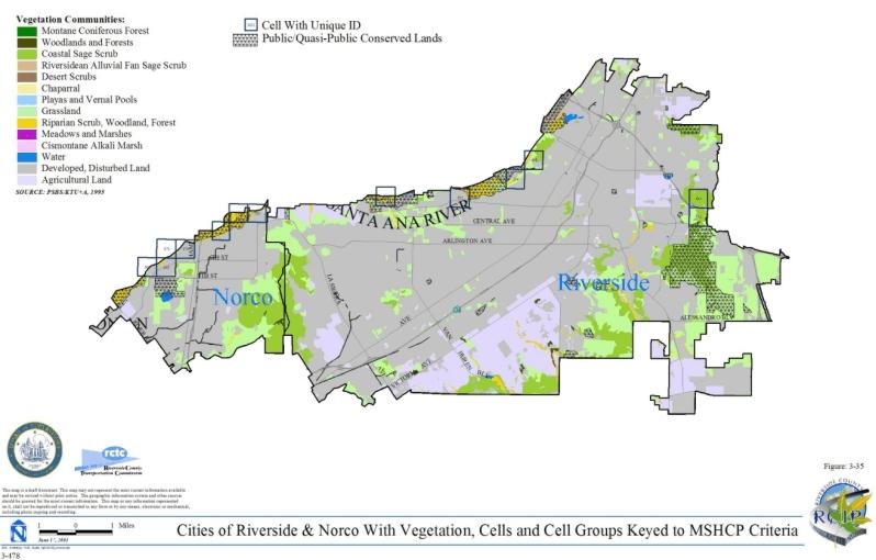
- 3.3.17 Cities of Riverside/Norco Area Plan
- 3.4 Alternative Conservation Strategies Considered in the Conservation Planning Process
4.0 ASSEMBLING THE MSHCP CONSERVATION AREA
4.0 ASSEMBLING THE MSHCP CONSERVATION AREA
- 4.1 Summary of Actions to Assemble the MSHCP Conservation Area
- 4.2 Contributions of Existing Public Lands
- 4.3 Conservation of Privately Owned Lands
- 4.4 The Role of Federal and State Governments in Reserve Assembly
- 4.5 Actions by Local Governments
- 4.6 Private Conservation or Mitigation Areas/Conservation Banks
- 4.7 Indirect Fiscal Impacts of the MSHCP
5.0 MANAGEMENT AND MONITORING
5.0 MANAGEMENT AND MONITORING
- 5.1 Management/Adaptive Management Framework
- 5.2 MSHCP Management and Adaptive Management Programs
- 5.3 Biological Monitoring Program
- 5.3.1 Introduction
- 5.3.2 Monitoring Goals and Objectives
- 5.3.3 Monitoring Program Implementation Sequence
- 5.3.4 Inventory, Monitoring, and Sampling Considerations
- 5.3.5 Vegetation Community/Wildlife Habitat Inventory and Monitoring
- 5.3.6 Covered Species Inventory and Monitoring
- 5.3.7 Responsibilities, Coordination, and Reporting
- 5.3.8 Data Management
- 5.3.9 Anticipated Levels of effort and Estimated Costs
6.0 MSHCP IMPLEMENTATION STRUCTURE
6.0 MSHCP IMPLEMENTATION STRUCTURE
- 6.1 Local Implementation Measures
- 6.1.1 Property Owner Initiated Habitat Evaluation and Acquisition Negotiation Strategy (HANS)
- 6.1.2 Protection of Species Associated with Riparian/Riverine areas and Vernal Pools
- 6.1.3 Protection of Narrow Endemic Plant Species
- 6.1.4 Guidlines Pertaining to the Urban/Wildlands Interface
- 6.1.5 Maintenance of Existing Habitat Conditions Prior to Reserve Assembly
- 6.1.6 Mitigation Responsibilities
- 6.2 Agriculture
- 6.3 Database Updates and Refinements/Need for Surveys
- 6.4 Fuels Management
- 6.5 Criteria Refinement Process
- 6.6 Cooperative Organizational Structure for Implementation and Management of the MSHCP
- 6.7 Reserve Assembly Accounting
- 6.8 Assurances for Unforeseen and Changed Circumstances
- 6.9 Application of Certain FESA Requirements
- 6.10 Modifications and Amendments to the MSHCP
- 6.11 Annual Review and Oversight
7.0 COVERED ACTIVITIES/ALLOWABLE USES
7.0 COVERED ACTIVITIES/ALLOWABLE USES
- 7.1 Covered Activities Outside Criteria Area
- 7.2 Covered Activities Within Existing Public/Quasi-Public Lands
- 7.2.1 Existing Roads Within Existing Public/Quasi-Public Lands
- 7.2.2 Planned Roads Within Existing Public/Quasi-Public Lands
- 7.2.3 Cajalco Road Realignment and Widening
- 7.2.4 Future Facilities Within Public/Quasi-Public Lands
- 7.2.5 Maintenance of Other Existing Facilities Within Public/Quasi-Public Lands by Permittees
- 7.2.6 Existing Agricultural Uses Within Local Public/Quasi-Public Lands
- 7.3 Covered Activities Inside Criteria Area
- 7.3.1 Public and Private Development Consistent with MSHCP Criteria
- 7.3.2 Single-Family Homes on Existing Legal Parcels Within the Criteria Area
- 7.3.3 Agricultural Lands Within the Criteria Area
- 7.3.4 Existing Roads Within the Criteria Area
- 7.3.5 Planned Roads Within the Criteria Area
- 7.3.6 State Park Facilities
- 7.3.7 Flood Control Facilities
- 7.3.8 Waste Management Facilities
- 7.3.9 Future Facilities
- 7.4 Allowable Uses in MSHCP Conservation Area
- 7.5 Guidelines for Facilities Within the Criteria Area and Public/Quasi-Public Lands
8.0 MSHCP FUNDING/FINANCING OF RESERVE ASSEMBLY AND MANAGEMENT
8.0 MSHCP FUNDING/FINANCING OF RESERVE ASSEMBLY AND MANAGEMENT
- 8.1 Introduction
- 8.2 Estimated Costs of Plan Implementation
- 8.3 Costing the Local Implementation Program
- 8.4 Local Implementation Plan
- 8.5 Local Funding Program
- 8.6 Adequacy of Funding
- 8.6.1 Additional Funding Needs Resulting from Land Acquisition Costs Increasing Faster than Revenues
- 8.6.2 Increased Funding Needs Resulting from Management or Monitoring Costs Increasing Faster than Revenues
- 8.6.3 Increased Funding Needs Resulting from Adaptive Management Costs Increasing Faster than Revenues or the Endowment Projection Not Being Met
- 8.6.4 Need for Additional Funding Resulting From the Need to Acquire More than 56,000 Acres Locally Due to the Conservation Anticipated under Section 8.3.1
- 8.6.5 Revenue Collections and Land Acquisitions do not Keep Pace with Land Development
- 8.7 Use of Debt Financing to Address Need for Cash Flow Increase
- 8.8 Long-Term Financing for Management
- 8.9 Participation by Cities
- 8.10 Approach to Costs and Funding Projection
9.0 CONSERVATION AND INCIDENTAL TAKE ESTIMATES
10.0 ACKNOWLEDGMENTS
APPENDICES
- Appendix A Planning Agreement
- Appendix B Supporting Documentation for Funding of the MSHCP
- B-01 Appendix B-01
- B-02A Budget Years 1-5
- B-02A Budget Years 6-10
- B-02A Budget Years 11-15
- B-02A Budget Years 16-20
- B-02A Budget Years 21-25
- B-02A Staffing Years 1-5
- B-02A Staffing Years 6-10
- B-02A Staffing Years 11-15
- B-02A Staffing Years 16-20
- B-02A Staffing Years 21-25
- B-02A 25 Year Budget
- B-02A 25 Year Projected Staffing
- B-03 Appendix B-03
- B-04 Budget 02-03
- B-04 Equipment
- B-05 Conceptual MSHCP Implementation Alternatives
- B-06 Appendix B-06
- B-07 Riverside County Transportation Commission Transportation Expenditure Plan and Retail Transaction and Use Tax Ordinance
- B-08 RCIP Comparison of Year 2000 Lane Miles to General Plan Buildout Lane Miles
- B-08 Lane-Miles
- B-09 Waste Management Tonnage Estimate and Auxiliary Collection Estimates
- B-09 Calculated Information
- Appendix C Standard Best Management Practices
- Appendix D Model Conservation Easement
- Appendix E Summary of Species Survey Requirements
LIST OF FIGURES
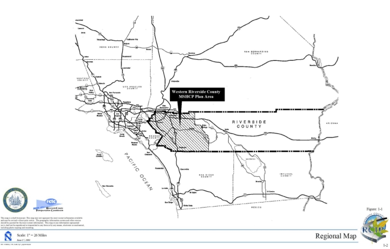
- 1-1 Regional Map
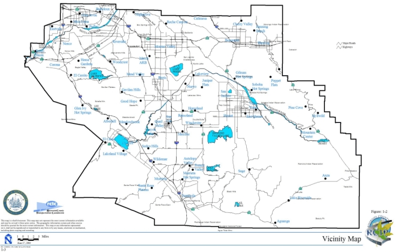
- 1-2 Vicinity Map
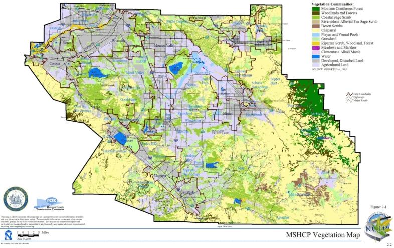
- 2-1 MSHCP Vegetation Map
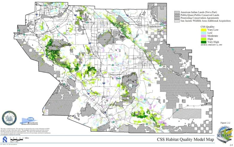
- 2-2 CSS Habitat Quality Model Map
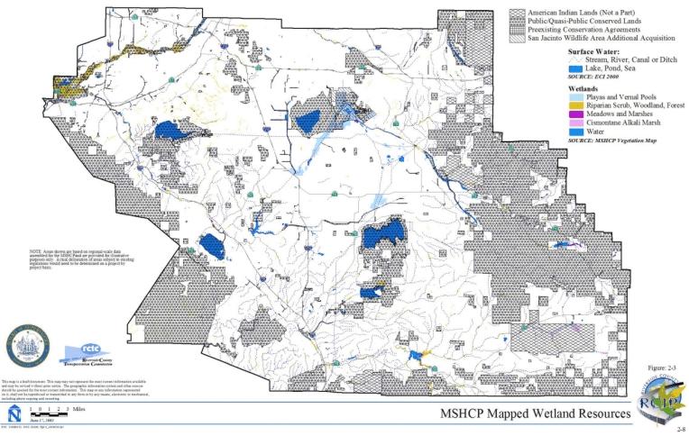
- 2-3 MSHCP Mapped Wetland Resources
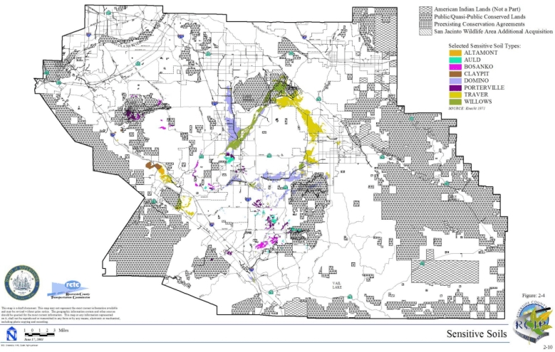
- 2-4 Sensitive Soils
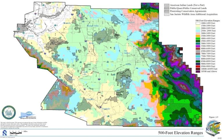
- 2-5 500-Foot Elevation Ranges
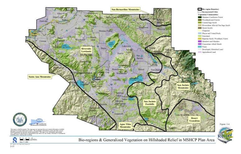
- 2-6 Bio-Regions & Generalized Vegetation on Hillshaded Relief in MSHCP Plan Area
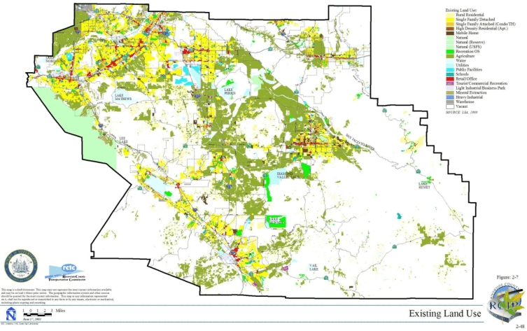
- 2-7 Existing Land Use
- 2-8 Area Plans and Cities
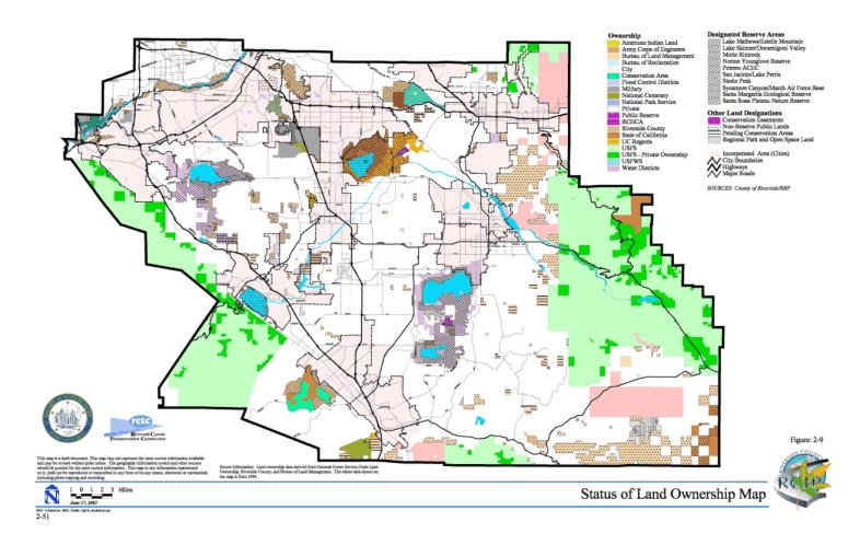
- 2-9 Status of Land Ownership Map
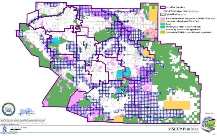
- 3-1 MSHCP Plan Map
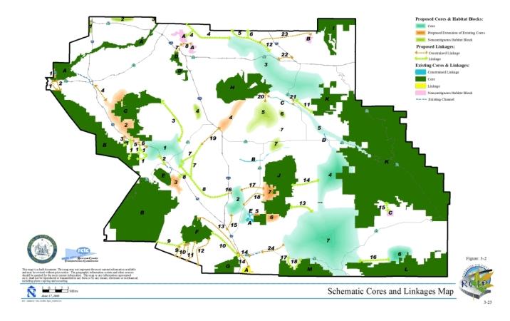
- 3-2 Schematic Cores and Linkages Map
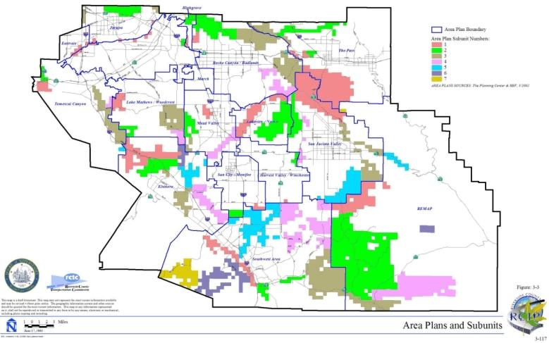
- 3-3 Area Plans and Subunits
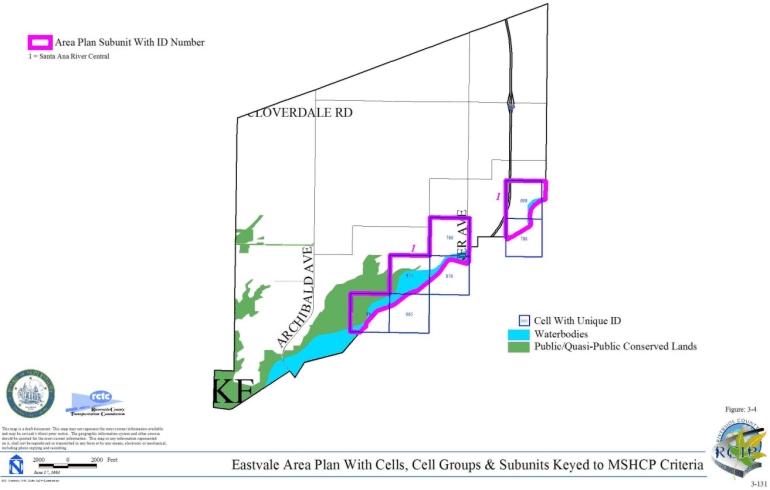
- 3-4 Eastvale Area Plan with Cells, Cell Groups & Subunits Keyed to MSHCP Criteria
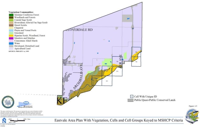
- 3-5 Eastvale Area Plan with Vegetation, Cells and Cell Groups Keyed to MSHCP Criteria
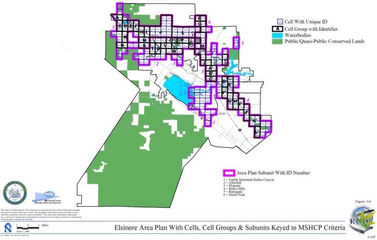
- 3-6 Elsinore Area Plan with Cells, Cell Groups & Subunits Keyed to MSHCP Criteria
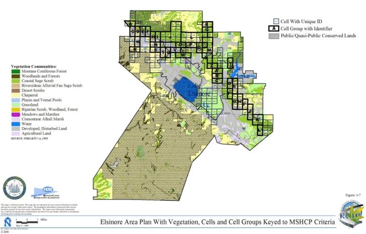
- 3-7 Elsinore Area Plan with Vegetation, Cells and Cell Groups Keyed to MSHCP Criteria
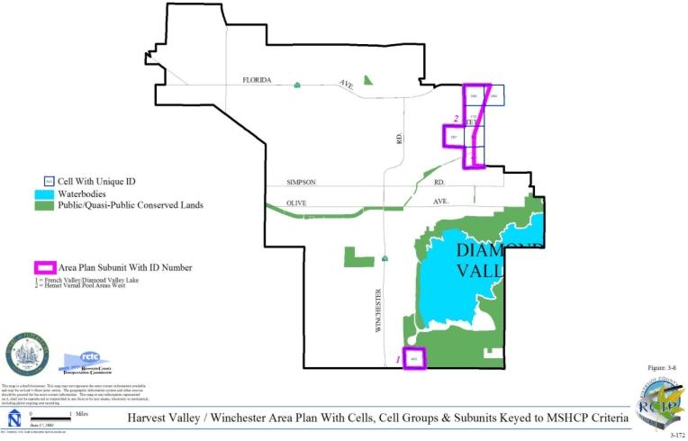
- 3-8 Harvest Valley/Winchester Area Plan with Cells, Cell Groups & Subunits Keyed to MSHCP Criteria
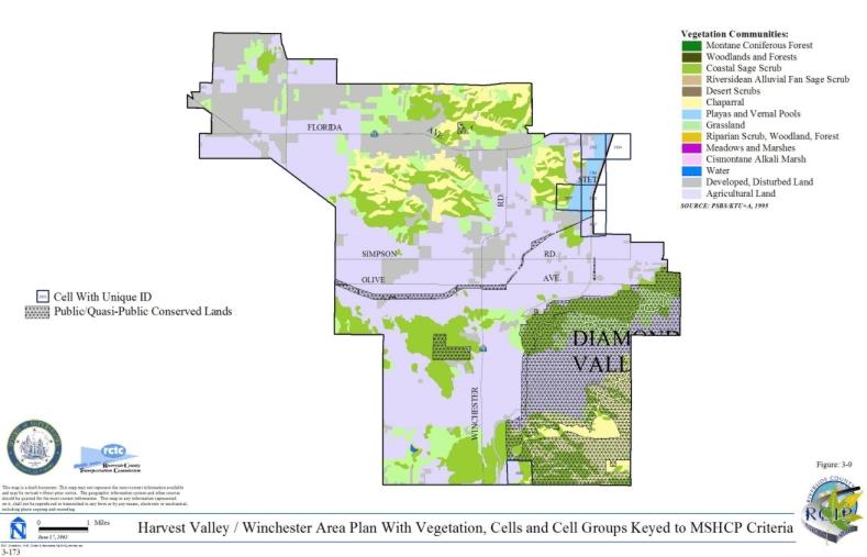
- 3-9 Harvest Valley/Winchester Area Plan with Vegetation, Cells and Cell Groups Keyed to MSHCP Criteria
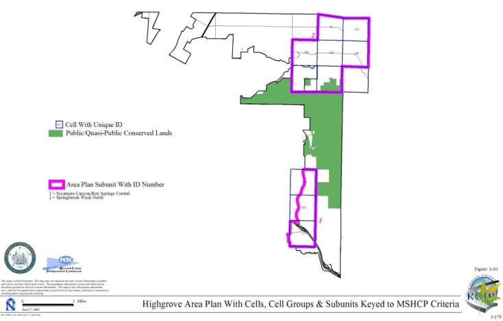
- 3-10 Highgrove Area Plan with Cells, Cell Groups & Subunits Keyed to MSHCP Criteria
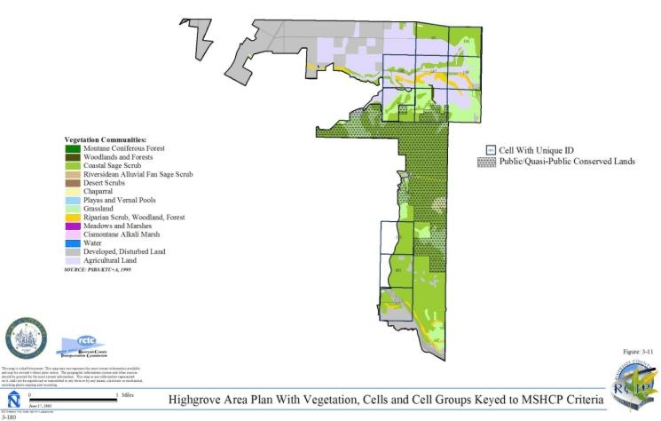
- 3-11 Highgrove Area Plan with Vegetation, Cells and Cell Groups Keyed to MSHCP Criteria
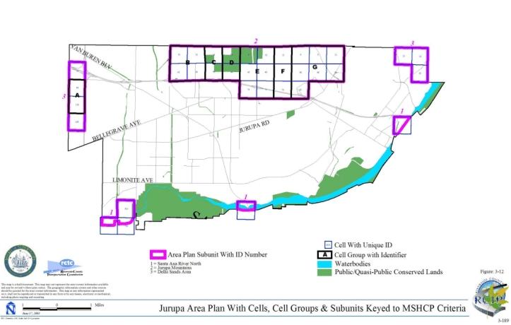
- 3-12 Jurupa Area Plan with Cells, Cell Groups & Subunits Keyed to MSHCP Criteria
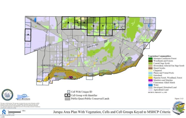
- 3-13 Jurupa Area Plan with Vegetation, Cells and Cell Groups Keyed to MSHCP Criteria
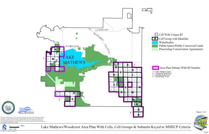
- 3-14 Lake Mathews Area Plan with Cells, Cell Groups & Subunits Keyed to MSHCP Criteria
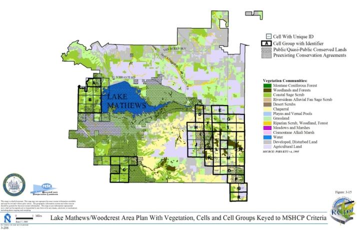
- 3-15 Lake Mathews Area Plan with Vegetation, Cells and Cell Groups Keyed to MSHCP Criteria
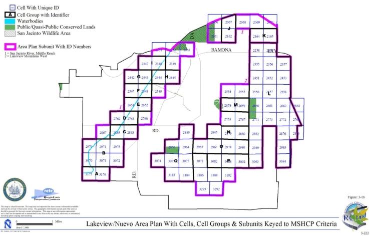
- 3-16 Lakeview/Nuevo Area Plan with Cells, Cell Groups & Subunits Keyed to MSHCP Criteria
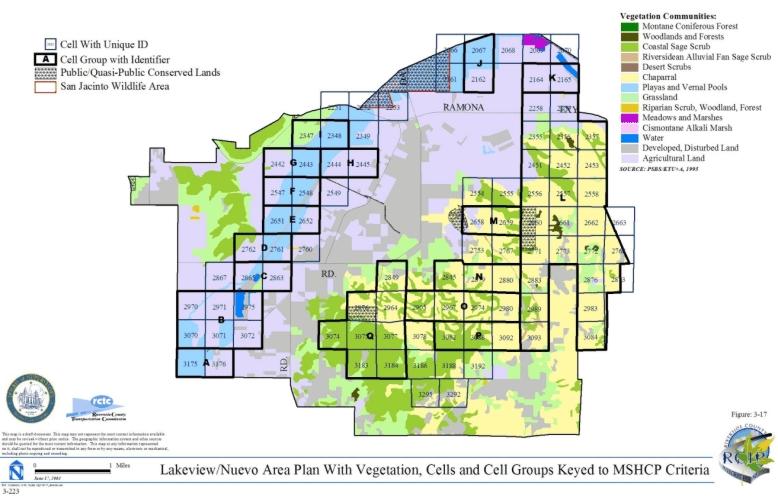
- 3-17 Lakeview/Nuevo Area Plan with Vegetation, Cells and Cell Groups Keyed to MSHCP Criteria
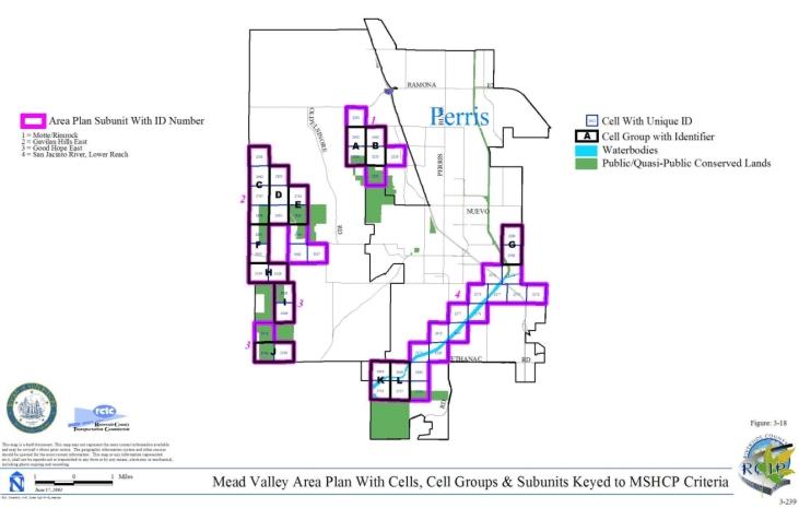
- 3-18 Mead Valley Area Plan with Cells, Cell Groups & Subunits Keyed to MSHCP Criteria
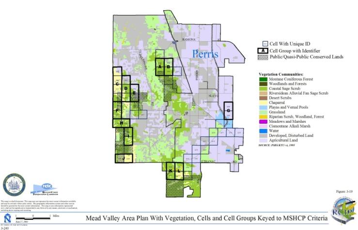
- 3-19 Mead Valley Area Plan with Vegetation, Cells and Cell Groups Keyed to MSHCP Criteria
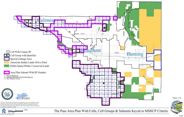
- 3-20 The Pass Area Plan with Cells, Cell Groups & Subunits Keyed to MSHCP Criteria
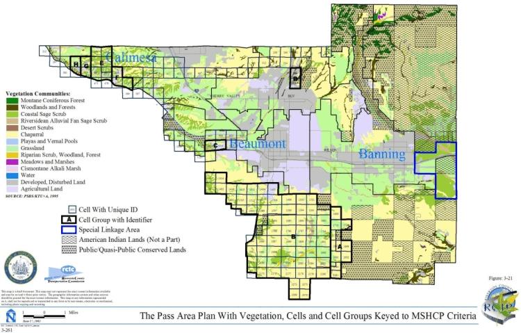
- 3-21 The Pass Area Plan with Vegetation, Cells and Cell Groups Keyed to MSHCP Criteria
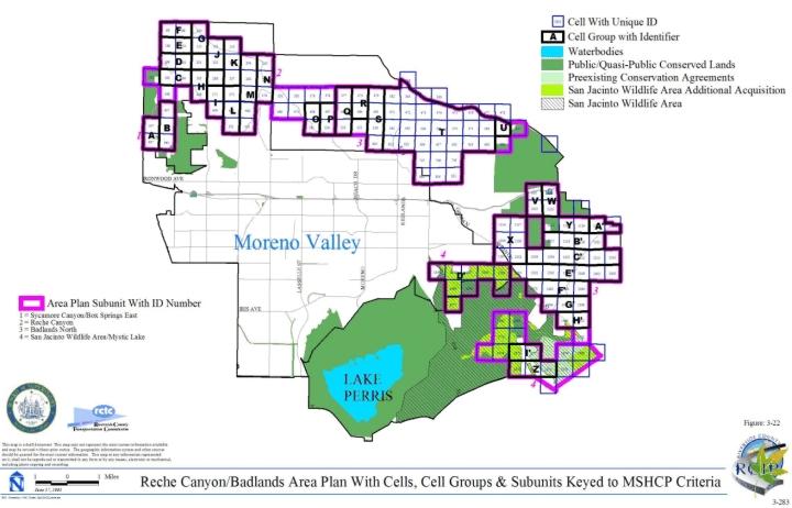
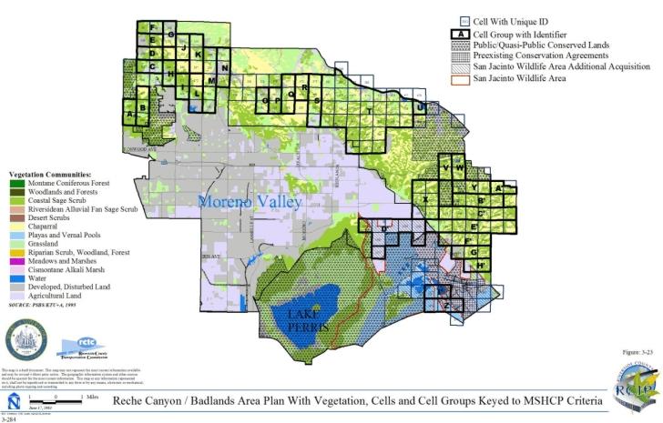
- 3-22 Reche Canyon/Badlands Area Plan with Cells, Cell Groups & Subunits Keyed to MSHCP Criteria
- 3-23 Reche Canyon/Badlands Area Plan with Vegetation, Cells and Cell Groups Keyed to MSHCP Criteria
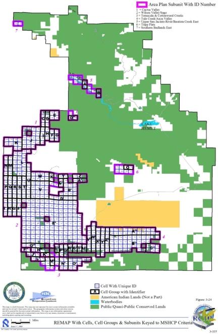
- 3-24 REMAP Area Plan with Cells, Cell Groups & Subunits Keyed to MSHCP Criteria
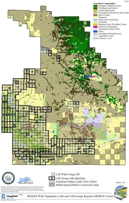
- 3-25 REMAP Area Plan with Vegetation, Cells and Cell Groups Keyed to MSHCP Criteria
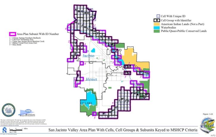
- 3-26 San Jacinto Valley Area Plan with Cells, Cell Groups & Subunits Keyed to MSHCP Criteria
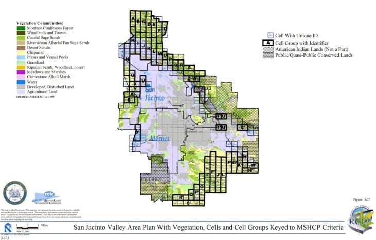
- 3-27 San Jacinto Valley Area Plan with Vegetation, Cells and Cell Groups Keyed to MSHCP Criteria
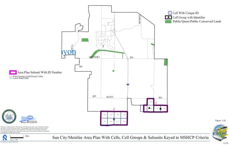
- 3-28 Sun City/Menifee Area Plan with Cells, Cell Groups & Subunits Keyed to MSHCP Criteria
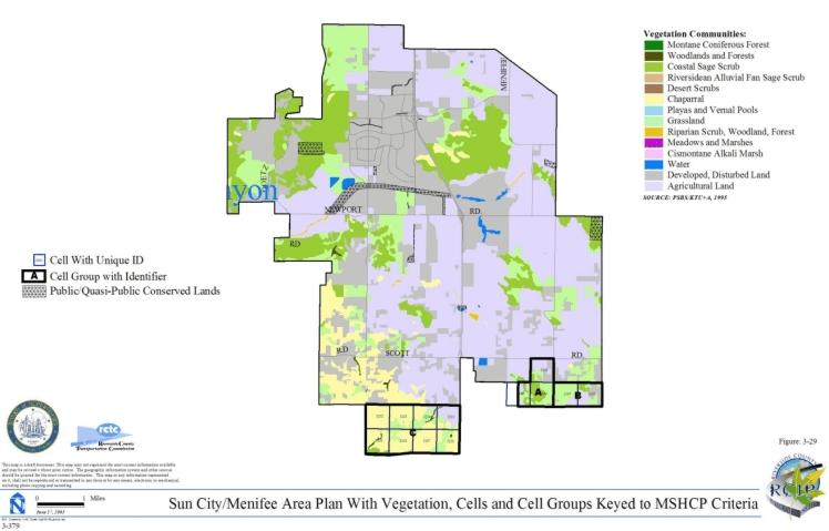
- 3-29 Sun City/Menifee Area Plan with Vegetation, Cells and Cell Groups Keyed to MSHCP Criteria
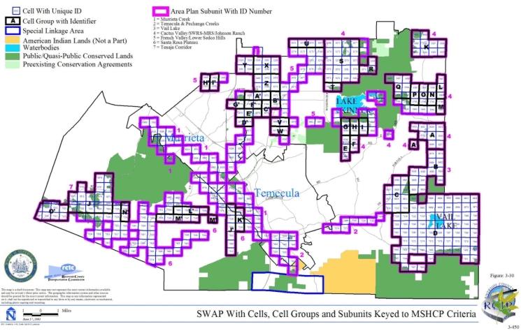
- 3-30 SWAP Area Plan with Cells, Cell Groups & Subunits Keyed to MSHCP Criteria
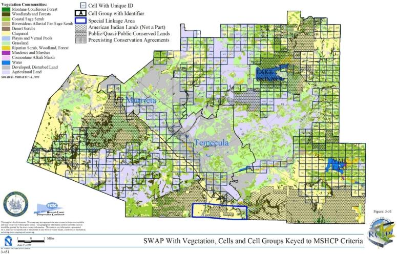
- 3-31 SWAP Area Plan with Vegetation, Cells and Cell Groups Keyed to MSHCP Criteria
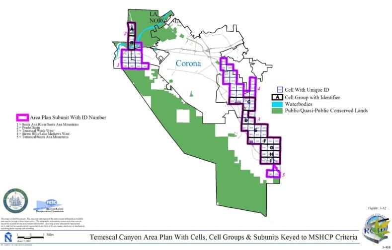
- 3-32 Temescal Canyon Area Plan with Cells, Cell Groups & Subunits Keyed to MSHCP Criteria
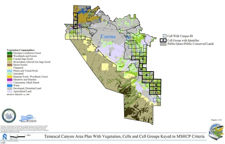
- 3-33 Temescal Canyon Area Plan with Vegetation, Cells and Cell Groups Keyed to MSHCP Criteria
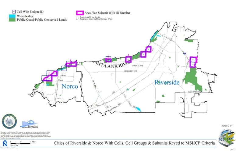
- 3-34 Cities of Riverside & Norco with Cells, Cell Groups & Subunits Keyed to MSHCP Criteria
- 3-35 Cities of Riverside & Norco with Vegetation, Cells and Cell Groups Keyed to MSHCP Criteria
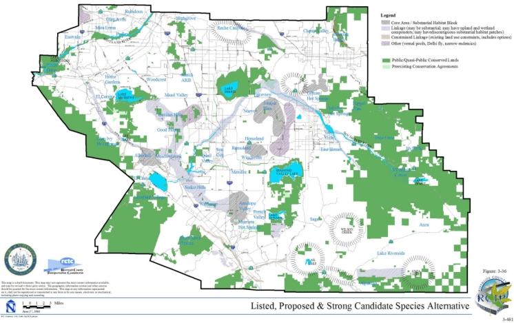
- 3-36 Listed, Proposed and Strong Candidate Species Alternative
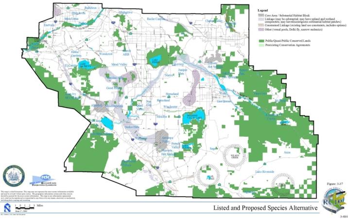
- 3-37 Listed and Proposed Species Alternative
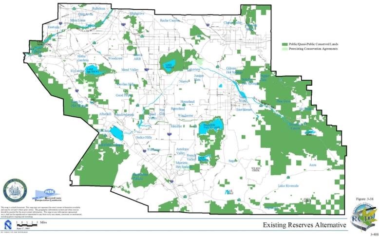
- 3-38 Existing Reserves Alternative
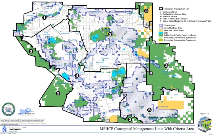
- 5-1 MSHCP Conceptual Management Units with Criteria Area
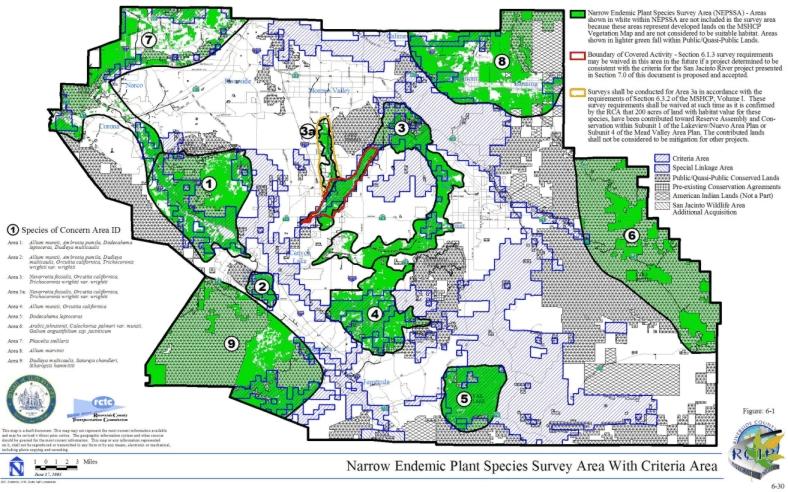
- 6-1 Narrow Endemic Plant Species Survey Area with Criteria Area
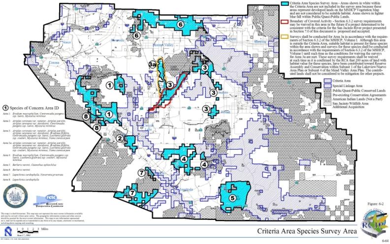
- 6-2 Criteria Area Species Survey Area
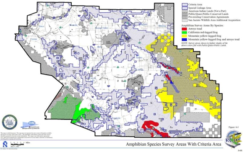
- 6-3 Amphibian Species Survey Areas with Criteria Area
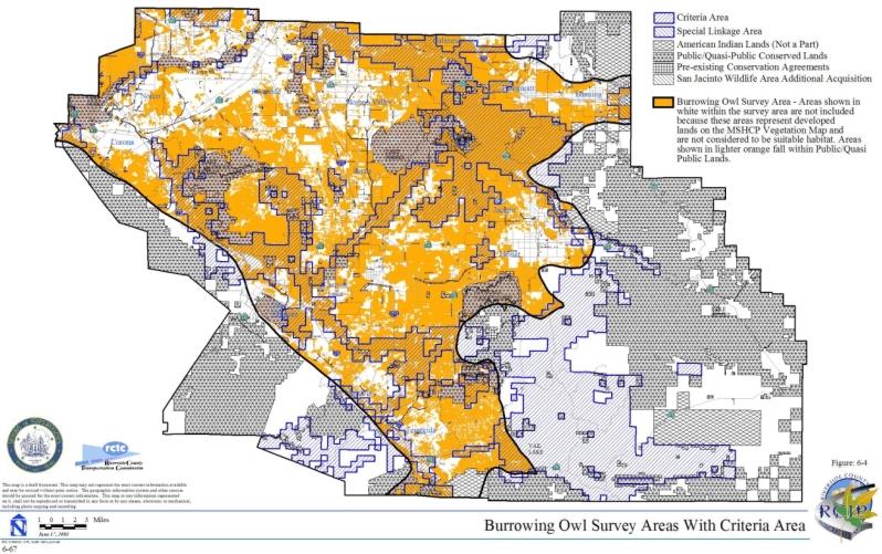
- 6-4 Burrowing Owl Survey Areas with Criteria Area
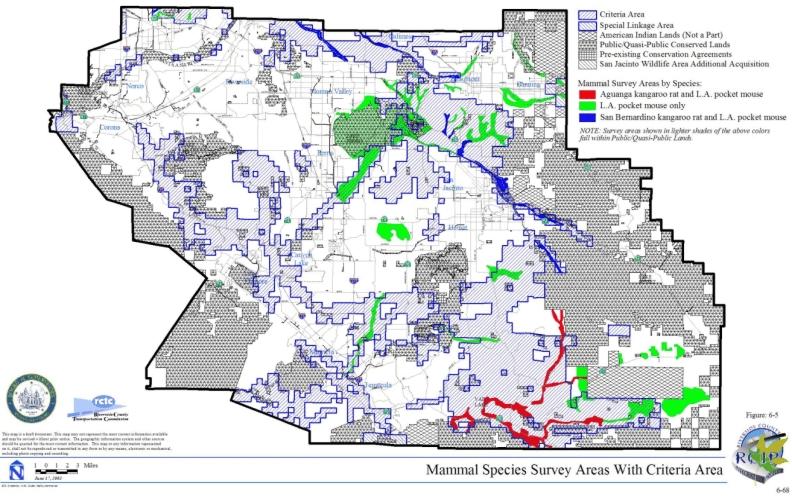
- 6-5 Mammal Species Survey Areas with Criteria Area
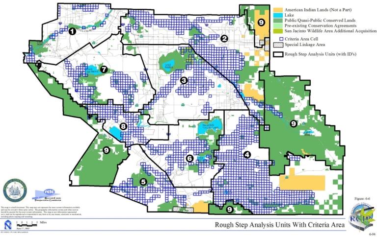
- 6-6 Rough Step Analysis Units with Criteria Area
- 7-1 General Plan Circulation Element with Criteria Area
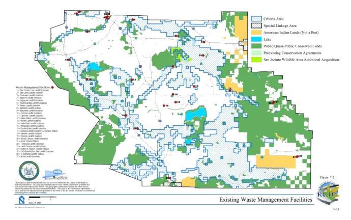
- 7-2 Existing Waste Management Facilities
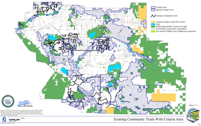
- 7-3 Existing Community Trails with Criteria Area
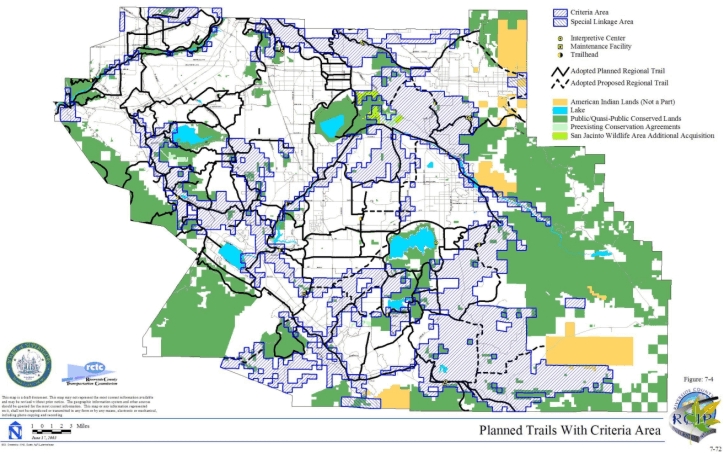
- 7-4 Planned Trails with Criteria Area
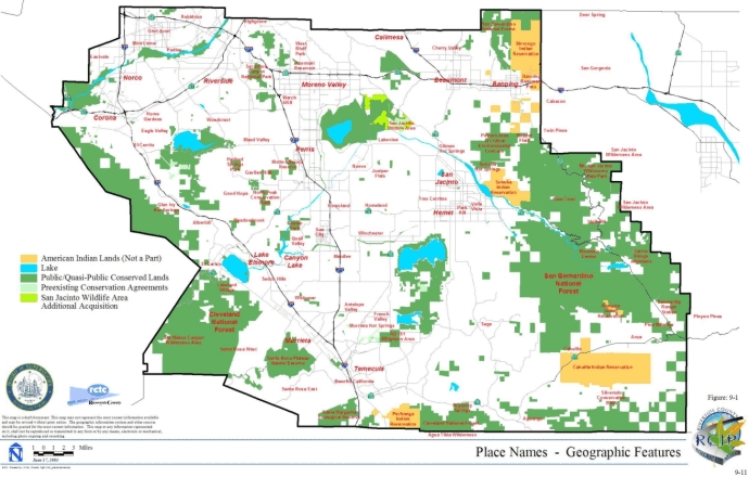
- 9-1 Place Names - Geographic Features
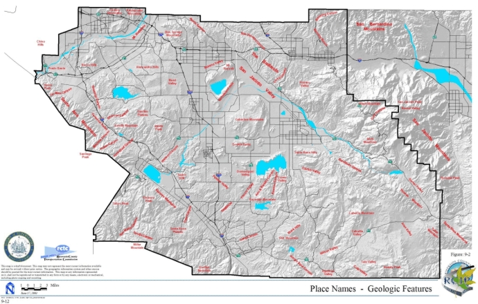
- 9-2 Place Names - Geologic Features
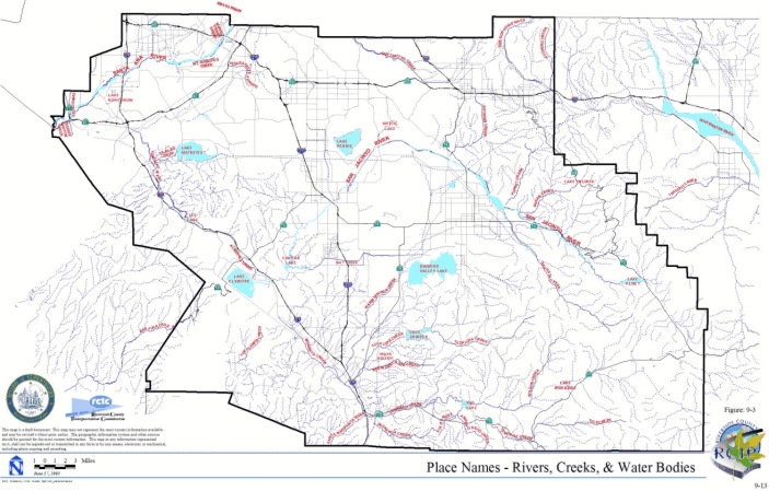
- 9-3 Place Names - Rivers, Creeks & Water Bodies
- 9-4 Bioregions with Criteria Area
- 9-5 CSS Habitat Quality Model Map with Criteria Area
- 9-6 MSHCP Mapped Wetland Resources with Criteria Area
- 9-7 Sensitive Soils with Criteria Area
- 9-8 500-foot Elevation Ranges with Criteria Area
- 9-9 Delhi Sands Flower-loving Fly Suitable Habitat with Criteria Area
- 9-10 Delhi Sands Flower-loving Fly Soild with Criteria Area
LIST OF TABLES
LIST OF TABLES
- 2-1 Summary of Collapsed and Uncollapsed Vegetation Communities Classification
- 2-2 Species Considered for Conservation under the MSHCP since 1999
- 2-3 Land Distribution by Jurisdiction
- 2-4 Planned Land Uses Within Unincorporated County Land
- 2-5 Planned Land Uses Within Incorporated Land
- 2-6 Existing Vs. Planned Land Use Within Western Riverside County
- 3-1 Estimate of Conservation by Vegetation Community
- 3-2 Target Acreage Ranges by Area Plan Subunit
- 3-3 Criteria for Eastvale Area Plan
- 3-4 Criteria for Elsinore Area Plan
- 3-5 Criteria for Harvest Valley/Winchester Area Plan
- 3-6 Criteria for Highgrove Area Plan
- 3-7 Criteria for Jurupa Area Plan
- 3-8 Criteria for Lake Mathews/Woodcrest Area Plan
- 3-9 Criteria for Lakeview/Nuevo Area Plan
- 3-10 Criteria for Mead Valley Area Plan
- 3-11 Criteria for The Pass Area Plan
- 3-12 Criteria for Reche Canyon/Badlands Area Plan
- 3-13 Criteria for REMAP Area Plan
- 3-14 Criteria for San Jacinto Valley Area Plan
- 3-15 Criteria for Sun City/Menifee Area Plan
- 3-16 Criteria for Southwest Area Plan
- 3-17 Criteria for Temescal Canyon Area Plan
- 3-18 Criteria for Cities of Riverside and Norco
- 3-19 Listed, Proposed and Strong Candidate Species Alternative Vegetation Summary
- 3-20 Listed and Proposed Species Alternative Vegetation Summary
- 3-21 Existing Reserves Alternative Vegetation Summary
- 3-22 Summary of Potential Species Conservation under Existing Reserves Alternative
- 3-23 Summary of Existing Reserves Within MSHCP Plan Area
- 3-24 Existing Listed Species Within the MSHCP Plan Area
- 4-1 Estimated Conservation of Habitat on Private Lands in Plan Area by Vegetation Community
- 4-2 Estimated Conservation of Habitat on Private Lands in Plan Area by Area Plan
- 4-3 MSHCP Reserve Assembly Lands Conserved Between February 3, 2000 and July 31, 2002
- 5-1 Factors to Be Considered in Management Responses to Disturbance Regimes
- 5-2 MSHCP Covered Species Management Matrix
- 5-3 Existing Management Entities for Management Unit 1
- 5-4 Existing Management Entities for Management Unit 2
- 5-5 Existing Management Entities for Management Unit 3
- 5-6 Existing Management Entities for Management Unit 4
- 5-7 Existing Management Entities for Management Unit 5
- 5-8 Summary of Survey Requirements for Covered Species as per the Species Objectives
- 5-9 Estimated Total Personnel - Years by Level of Effort and Position Level
- 5-10 Estimated Total Cost (In 2002 Dollars) for Personnel and Equipment/Supplies by Level of Effort and Position Level
- 6-1 Narrow Endemic and Criteria Area Survey Plant Species Attributes and Habitat Affinities
- 6-2 Plants That Should Be Avoided Adjacent to the MSHCP Conservation Area
- 6-3 Additional Reserve Lands Within Rough Step Analysis Units by Vegetation Community
- 7-1 Existing Roads Within Public/Quasi-Public Lands
- 7-2 Hemet to Corona/Lake Elsinore Impacts Within Public/Quasi-Public Lands
- 7-3 Existing Roads Permitted to Remain in the Criteria Area
- 7-4 Planned Facilities
- 7-5 Circulation Element Roadways Impacts to Vegetation Communities Occurring Within the Criteria Area
- 7-6 Summary of Vegetation Communities Impacted by Freeways
- 7-7 Winchester to Temecula Alternative 1 Impacts to Vegetation Communities Occurring Within the Criteria Area
- 7-8 Hemet to Corona/Lake Elsinore Alternative 1b Impacts to Vegetation Communities Occurring Within the Criteria Area
- 7-9 Hemet to Corona/Lake Elsinore Alternatives 5a & 5e Shared Alignment - Impacts to Vegetation Communities Occurring Within the Criteria Area
- 7-10 Hemet to Corona/Lake Elsinore Alternatives 5a Impacts to Vegetation Communities Occurring Within the Criteria Area
- 7-11 Hemet to Corona/Lake Elsinore Alternatives 5c Impacts to Vegetation Communities Occurring Within the Criteria Area
- 7-12 Hemet to Corona/Lake Elsinore Alternatives 5e Impacts to Vegetation Communities Occurring Within the Criteria Area
- 7-13 San Bernadino to Moreno Valley Corridor Impacts to Vegetation Communities Occurring Within the Criteria Area
- 7-14 Potential Flood Control Projects Within the MSHCP Criteria Area
- 7-15 Waste Management Facilities Within Public/Quasi-Public Lands and the Criteria Area
- 7-16 Assumptions for Covered Trails and Facilities Within the MSHCP Conservation Area
- 7-17 Anticipated Impacts for Covered Trails and Facilities Within the MSHCP Conservation Area
- 7-18 Anticipated Impacts for Covered Trails and Facilities Within the MSHCP Conservation Area by Vegetation Community
- 8-1 Assembly of Additional Reserve Lands
- 8-2 Total Local Program Costs
- 8-3 Local Land Acquisition Costs
- 8-4 Local Reserve Management
- 8-5 Local Public/Regional Funding Sources
- 9-1 Overall Vegetation Community Conservation and Impact Estimates
- 9-2 Species Conservation Summary
- 9-3 Requirements to Be Met for 28 Species Prior to Including Those Species on the List of Covered Species Adequately Conserved