

Volume 4 - 4.0 Environmental Impacts / Environmental Consequences
4.0 ENVIRONMENTAL IMPACTS / ENVIRONMENTAL CONSEQUENCES
This document has been prepared as a joint EIR/EIS as a result of the combined local, State, and federal actions associated with the approval of the proposed MSHCP. As stated in the Purpose and Need (Section 1.0), the co-lead agencies are the County of Riverside, pursuant to CEQA, and the USFWS, pursuant to NEPA. A consistent format was used to assist the reader in understanding the implications of the proposed MSHCP and alternatives. This section provides a narrative of how the analysis was undertaken and presents the organization of the environmental consequences section of the document.
This section of the EIR/EIS forms the scientific and analytical basis for the evaluation of the proposed MSHCP and alternatives. Topics analyzed include biological resources; land use and planning; population, housing and employment; public services (fire protection and parks); and transportation and circulation. Sections are presented in the following format.
Thresholds of Significance/Criteria for Determining Significance
The criteria for determining significance provide a threshold at which a significant impact will occur. Criteria will differ among issues.
Impact Analysis per Issue Statement
This section of the document provides an evaluation of project-specific and alternatives impacts and determines significance based on documented thresholds levels. The Proposed Project/Action is the MSHCP as described in Section 2.3.1 of this EIR/EIS, to include the whole of the action (policy statements, issuance of incidental take authorizations, and the implementing agreement).
According to NEPA, each of the alternatives to the Proposed Action must be analyzed in equal detail as the Proposed Action. In this Section of the EIR/EIS, each environmental issue described in Section 3.0 of this document is analyzed with regard to potential effects related to the proposed MSHCP (Proposed Action) and to each of the four alternatives as well (Listed, Proposed, and Strong Candidate Species Alternative; Listed and Proposed Species Alternative; Existing Reserves Alternative; and the No Project/No MSHCP Alternative).
The Proposed Action and the alternatives are analyzed for direct, indirect, and cumulative impacts/effects.
Mitigation Measures
For those impacts that were determined to be significant, mitigation is provided in this section of the impact analysis.
Level of Significance after Mitigation
An analysis of the significance of an effect after mitigation is applied is discussed in this section of the impact analysis. The outcome of the analysis is to determine whether there is a significant effect caused by the proposed project or its alternatives that cannot be mitigated to below a level of significance.
4.1 Biological Resources
4.1.1 Introduction
This analysis
- Vegetation Communities
- Cores and Linkages
- Listed, Covered Species
- Relationship to Adopted or
- Non-Listed, Covered Species Approved HCPs and NCCPs
- Non-Covered Species
- Edge Effects
for biological resources applies the applicable threshold of significance to the potential effects for the Project and each alternative (with the exception of the No Project Alternative) for each of the following biological issues:
Subheadings for each of these issues appear in the analysis section for the project and alternatives. The No Project Alternative discussion is structured differently, since that alternative does not involve issuance of take authorization. The No Project Alternative discussion is formatted to address existing local, State and federal regulations, and the effects of the application of these regulations to future growth in the MSHCP Area.
Impact Analysis Considerations
Consideration in evaluating impacts to sensitive vegetation communities is based on the vegetation data base developed by Pacific Southwest Biological Services (PSBS, 1995) which is based on 1992-1993 aerial photographs. It is important to distinguish between “vegetation communities” and “habitats.” The terms often are used interchangeably, but a vegetation community precisely refers to definable and consistent assemblages of plant species, whereas habitat is the native environment of a plant or animal species.
The vegetation map as incorporated into the MSHCP database is depicted in Figure
4.1.1. This map was created by PSBS and mapped by KTU+A in 1995. As stated in the February 1995 PSBS/KTU+A Western Riverside County Multi-Species Habitat Conservation Plan Phase I Information Collection and Evaluation Report, this map was created by compiling all known vegetation information within the Plan Area. These data sources include biological survey reports, Weislander vegetation maps, satellite imagery and the Dangermond/RECON data set. Methods used to create and interpret vegetation data included aerial photograph interpretation, edge matching, digitizing, and geographically registering the data. In areas of concern, ground truthing occurred. Vegetation types were classified according to Holland. It should be noted that the vegetation map is representative of conditions at the time of the study; existing conditions today may differ from those represented on the map. The MSHCP vegetation map is limited by the time frame within which the data were assembled as well as the precision of those data. The Project encompasses all of western Riverside County, a
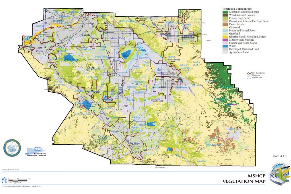
total of 1,966 square miles. Due to the large scale of the Project, it is simply not possible to map the Project area with parcel-level precision. Rather, vegetation mapping was based on a broad scale, as has been done with other criteria-based MSHCPs that cover large geographic regions, such as the San Diego MSCP. The vegetation map represents conditions at the time the data were assembled, in this case 1991-1995; the current extent and character of vegetation communities may differ from that depicted on the MSHCP vegetation map. Published and anecdotal data suggest that ecosystem state transition is occurring within some portions of the Plan Area - in particular, fire suppression has resulted in the conversion of frequently burned chaparral and coastal sage scrub to grassland and in shifts from Ponderosa pine and Jeffrey pine to incense cedar and white fir (Minnich, et al., 1995; Keeley, 1990; Zedler, et al., 1983). The MSHCP incorporates features to update the vegetation map as new information is obtained, such as the development of a new vegetation map as part of the MSHCP Monitoring Program. The timing and methodology for developing this map is described in Section 5.3 of this document. The criteria-based format of the MSHCP was designed, in part, to address changing data and/or conditions. The MSHCP calls for assembly of 153,000 acres of Additional Reserve Lands from within an approximately 300,000-acre Criteria Area. Reserve Assembly will involve review of a variety of project-specific vegetation data to refine and guide the Reserve Assembly process. This criteria-based format differs somewhat from large-scale NCCPs/HCPs for which a specific reserve boundary is delineated on a map at the time of permit issuance. Under that type of approach, validation of the vegetation map at the landscape level may be more important than under the criteria-based approach selected for this MSHCP. The organizational structure established for the MSHCP, as described in Section 6.6 of this document, also provides opportunities to incorporate new information during the term of the MSHCP Permit(s).
Consideration in evaluation of impacts to species is based on the MSHCP Species Occurrence Database. The University of California at Riverside (UCR) has assembled a species occurrence database for use during the MSHCP planning process. This database is accessible via http://ecoregion.ucr.edu/mshcp, and is a clearinghouse for biological information for the MSHCP. Occurrence information has been compiled from museum records, USFWS data, published and unpublished accounts, environmental impact reports, and field notes of local naturalists. As of August 2001, this database contained over 12,800 records. It should be noted that the species occurrence data represent known records of species observations. Actual presence and distribution of individual species within the MSHCP Area are likely greater than those reflected in the species occurrence database. Therefore, the analysis contained in this EIR/EIS also includes consideration of vegetation community associations for covered species. As noted in later sections of this analysis, impacts to non-covered species are not quantifiable due to the lack of information available for these species.
Considerations in evaluating reserve design and biological function of cores and linkages involve the following general principles of conservation biology:
- Conservation of focus species and their habitats throughout the MSHCP Area;
- Conservation of large habitat blocks;
- Maintenance of habitat diversity;
- Contiguity and connectivity of Conservation Areas; and
- Protection of Conservation Areas from encroachment and invasion by nonnative species.
Specific considerations in evaluating cores and linkages are based on the discussion of the function of cores and linkages contained in Section 3.1 of the MSHCP. The effects of the various alternatives on identified cores and linkages are based on the configuration of the Conservation Areas proposed under each alternative. The evaluation of impacts to cores and linkages is considered in the report prepared by the California Wilderness Coalition in November 2000. The report identified the location and major threats to wildlife movement corridors throughout the State of California (California Wilderness Coalition, 2000). The report identified 232 linkages within the State, of which 17 are located within the MSHCP Area. As part of this analysis, a review of the 17 linkages was conducted to compare reserve features of the MSHCP to the linkages identified by the California Wilderness Coalition.
The evaluation of impacts related to Covered Activities is based on the inventory of Covered Activities contained in Section 7.0 of the MSHCP. As stated below, it is assumed that the same list of covered activities would apply to all of the plan alternatives.
Consideration of regional resource planning is based on the following existing planning efforts. As shown in Figure 4.1.2, resource conservation planning efforts surrounding the MSHCP Area consist of the following:
(1) San Bernardino Preliminary MSHCP Planning Area. This conservation planning effort is adjacent to the northern border of the MSHCP Area and encompasses approximately 500 square miles containing six unique habitat types, six State endangered or threatened species, 13 federally endangered or threatened species, and over 53 species of special concern. San Bernardino County, through its Natural History Museum staff, has been conducting biological and botanical surveys for the past several years in order to identify habitat needs and requirements for the various sensitive species.
(2) Coachella Valley MSHCP Alternative 2. This conservation planning effort covers the central portion of Riverside County (adjacent to the eastern border of the MSHCP Area) which is the westernmost edge of the Sonoran Desert. The plan area covers 1,136,261 acres, a diverse mixture of desert and mountain habitats and 28 species in the Coachella Valley. The Coachella Valley Association of Governments (CVAG) has prepared an Administrative Review Draft which reflects the work of the Scientific Advisory Committee, the Implementation Subcommittee, and the Project Advisory Group. After receiving comments from the local, State, and federal agencies, a Public Review Draft and Draft EIR/EIS is scheduled for release in 2002.
(3) County of San Diego Multiple Habitat Conservation and Open Space Program (MHCOSP). The MHCOSP is adjacent to the southern border of the MSHCP Area and the eastern border of the San Diego MSCP North County Subarea. The County of San Diego has deferred planning for this subregion until it completes its North County Subarea Plan MSCP amendment.
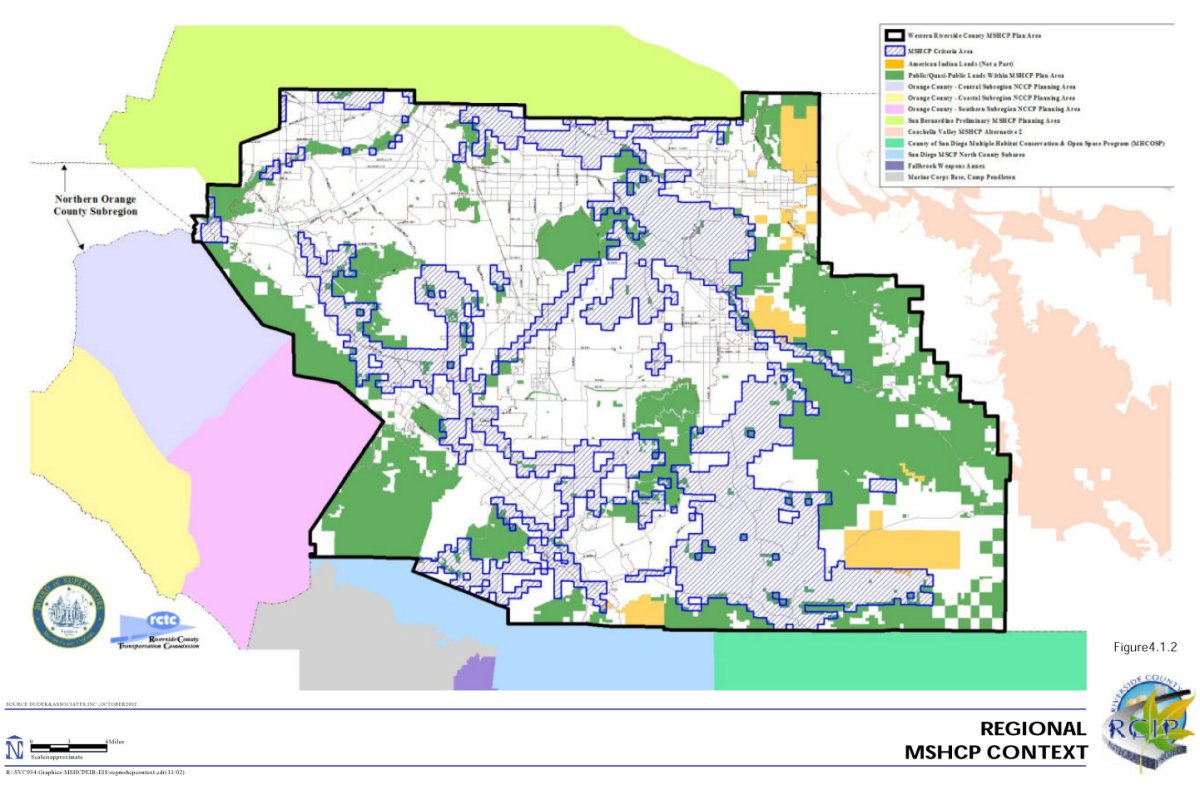
(4) San Diego Multiple Species Conservation Program (MSCP) North County Subarea. In December 1996, the California Department of Fish and Game (CDFG) and the U.S. Fish and Wildlife Service (USFWS) approved the San Diego MSCP habitat plan that encompasses 582,000 acres and establishes a 172,000-acre preserve system in southwestern San Diego County. This subregional plan covers 85 species of plants and animals and 23 vegetation types. The San Diego MSCP contains the North County Subarea, which is adjacent to the southern border of the Riverside County MSHCP Area and the western border of the MHCOSP County of San Diego. Lands formerly within the Multiple Habitat Conservation Program (MHCP) area have been redefined as the North County Subarea of the San Diego MSCP and will be amended into the MSCP. Additional biological information has been collected, and a science advisory process is underway. A subarea plan is anticipated to be provided for review shortly.
(5) Proposed Orange County Southern Subregion NCCP Planning Area. Orange County and major landowners are preparing a subregional preserve plan (NCCP/HCP) and special area management plan/master streambed alteration agreement that will integrate wetlands and endangered species permits. The Southern Subregion conservation planning effort is adjacent to the southern half of the western border of the MSHCP Area. An update to Orange County's General Plan and Zoning Ordinance is also underway. A public workshop was held in December 2001, to discuss alternatives that should be addressed for each of the three planning efforts in southern Orange County. Currently the Southern Subregion NCCP is in the public scoping process for the EIS/EIR that is anticipated to be provided for public review in the next few months.
(6) Orange County Central-Coastal Subregion NCCP Planning Area. This subregion NCCP borders the northern half of the western border of the MSHCP Area. This conservation plan was approved in July 1996 and establishes a 37,380-acre reserve system that includes significant areas of 12 major habitat types and covers 39 sensitive plant and animal species.
(7) Orange County Northern Subregion. This subregion borders a small portion of the northwestern corner of the MSHCP Area. This subregion is not a part of Orange County's NCCP plan, but a Chevron USA 4(d) permit concurrence letter was issued by the Wildlife Agencies that will allow Chevron to complete oil field abandonment operations in this subregion. The permit also commits Chevron to setting aside and managing a 28-acre preserve area for California gnatcatchers and funding cowbird control efforts.
4.1.2 Assumptions
The analysis of impacts to biological resources of the Proposed Action-MSHCP and the Plan alternatives - is also based on the following assumptions:
109) All of the following policies related to avoiding or reducing biological impacts, which are outlined in the MSHCP, would be incorporated into all of the proposed alternatives, with the exception of the No Project Alternative and the Existing Reserves Alternative:
- Wetlands avoidance and minimization (MSHCP, Section 6.1.2);
- Narrow endemics survey/conservation requirements (MSHCP, Section 6.1.3);
- Additional survey requirements (MSHCP, Section 6.3.2); and
- Guidelines pertaining to Urban/Wildlands Interface (MSHCP, Section 6.1.4).
110) With the exception of the No Project Alternative, all of the alternatives are assumed to include Adaptive Management and Monitoring for the species that are covered under each of the respective alternatives consistent with the measures described for those species in Section 5.0 of the MSHCP.
111) Implementation strategy (i.e., Criteria-based plan) is assumed to be the same for all of the alternatives, with the exception of the No Project Alternative and the Existing Reserves Alternative. It is assumed that Criteria would be established for these alternatives that would result in conservation in the same manner as the MSHCP Criteria.
112) Covered activities are assumed to be the same under all of the alternatives with the exception of the No Project Alternative and the Existing Reserves Alternative.
113) Through the MSHCP process, there has been a total of 254 species identified for analysis of potential conservation within the MSHCP Area. This includes the 247 species originally identified by the Wildlife Agencies early in the MSHCP development process, plus seven additional species considered in the planning process. It is assumed that the list of 254 species encompasses all species for which adequate information is available to conduct an analysis under CEQA and NEPA. Analysis of species other than the 254 identified that are not known to exist in the MSHCP Area, have not been identified, or have not been taxonomically distinguished, would involve speculation that is not within the scope of this analysis.
114) For the No Project Alternative, there would be no core/linkage system, no coordinated biological management, and no coordinated strategy for assembling contiguous blocks of reserve lands. Any conservation that would be achieved with the No Project Alternative would result from regulatory requirements imposed upon individual projects.
115) Lands defined as “Public/Quasi-Public” includes lands known to be in public ownership managed for conservation and/or open space value, or land contained in an existing reserve. Assembly of the public/quasi-public lands database revealed that approximately 347,000 acres of public/quasi-public lands are present within the MSHCP Plan Area, including approximately 200,000 acres of lands within the Cleveland or San Bernardino National Forests that are owned by the federal government and managed by the U.S. Forest Service. It is assumed that the same level of conservation and management that is described for the MSHCP would also occur under the other alternatives, with the exception of the No Project Alternative, with the only difference being the focus of management directed at the species covered under each of these alternatives.
116) For the purpose of this analysis, cumulative biological impacts are defined as those impacts resulting from development within the MSHCP Area as a result of build out of the County's and Cities' General Plans, in accordance with SCAG regional growth projections. The term of the MSHCP is proposed to be 75 years, and the MSHCP includes consideration of growth and development within the MSHCP Plan Area for build out of the General Plans. This analysis examines all of the alternatives under a General Plan build out scenario.
Therefore, the analysis of cumulative biological impacts of the Proposed Action and alternatives is assumed to be incorporated into the analysis of the alternatives themselves, since cumulative growth including build out of the General Plans in accordance with SCAG regional growth projections is considered in the MSHCP and the alternatives.
4.1.3 Thresholds of Significance/Criteria for Determining Significance
The following criteria are used to determine whether the Project or the alternatives would have significant impacts on biological resources. The impacts would be significant if implementation of the Project or the alternative being analyzed would:
- Have a substantial adverse effect, either directly or through habitat modifications, on any species identified as a candidate, sensitive, or special status species (including species listed as threatened or endangered) in local or regional plans, policies, or regulations, or by the CDFG or USFWS;
- Have a substantial adverse effect on any wetlands or other sensitive natural vegetation community identified in local or regional plans, policies, or regulations or by the California Department of Fish and Game or the United States Fish and Wildlife Service;
- Interfere substantially with the movement of any native resident or migratory fish or wildlife species or with established native resident or migratory wildlife corridors, impede the use of native wildlife nursery sites, or obstruct genetic flow for identified planning species;
- Conflict with the provisions of an adopted Habitat Conservation Plan, Natural Community Conservation Plan, or other approved local, regional, or State habitat conservation plan, either within the MSHCP Plan Area or in the surrounding region;
- Introduce land use within an area immediately adjacent to the MSHCP Conservation Area that would result in substantial edge effects; or
- Conflict with any local policies or ordinances protecting biological resources, such as a tree preservation policy or ordinance.
4.1.4 Impacts
MSHCP Proposed Project
Vegetation Communities. For the purposes of this analysis, vegetation types have been grouped into four primary categories: sensitive upland, wetland, forest, and agriculture. Sensitive upland communities include chaparral, coastal sage scrub, desert scrub, grassland (native grassland only, non-native grassland is not a sensitive community), and Riversidean alluvial fan sage scrub vegetation types. Wetland communities include meadows and marshes, playas and vernal pools, water and riparian scrub/woodland/forest vegetation types. Forest communities include montane coniferous forest, peninsular juniper woodland and scrub, and woodlands and forests.
For sensitive upland communities within the MSHCP Area, implementation of the proposed MSHCP would authorize take of 37 percent of chaparral, 48 percent of coastal sage scrub, 66 percent of desert scrub, 72 percent of grassland (including both native and non-native grassland), and 34 percent of Riversidean alluvial fan sage scrub (Table 4A).
For wetland communities within the MSHCP Area, the proposed MSHCP would authorize take of 76 percent of meadows and marshes, 15 percent of playas and vernal pools, 15 percent of water, and 26 percent of riparian scrub/woodland/forest. For forest communities within the MSHCP Area, the proposed MSHCP would authorize take of 31 percent of montane coniferous forest, and 32 percent of woodlands and forests. In addition, 88 percent of the agricultural land in the Plan Area would be authorized for take under the proposed MSHCP, as it would be outside the MSHCP Conservation Area and could be used for agricultural activities.
| Table 4A - Summary of Impacts to Vegetation Communities | |||||
|---|---|---|---|---|---|
| Vegetation Type | Total Acres in Plan Area | Proposed MSHCP Total Acres / % Within the Area Subject toTake Authorization |
Listed, Proposed, and Strong Candidate Species Alternative Total Acres / % Within the Area Subject to Take Authorization |
Listed and Proposed Species Alternative Total Acres / % Within the Area Subject to Take Authorization |
Existing Reserves Total Acres / % Within the Area Subject to Take Authorization |
| Agriculture | 169,480 | 149,460/88% | 143,100/84% | 143,100/84% | 158,000/93% |
| Chaparral | 434,950 | 162,670/37% | 187,960/43% | 200,560/46% | 227,570/52% |
| Coastal Sage Scrub | 156,450 | 74,730/48% | 82,71053% | 92,060/59% | 121,890/78% |
| Desert Scrub | 14,570 | 9,580/66% | 13,100/90% | 13,260/91% | 13,260/91% |
| Grassland | 154,140 | 111,320/72% | 116,110/75% | 120,120/78% | 131,330/85% |
| Meadows and Marshes2 | 2,280 | 1,730/76% | 1,850/81% | 1,870/82% | 1,950/86% |
| Montane Coniferous Forest | 29,910 | 9,410/31% | 9,400/31% | 9,400/31% | 9,430/31% |
| Playas and Vernal Pools | 7,910 | 1,160/15% | 2,060/26% | 2,060/26% | 4,990/63% |
| Riparian Scrub, Woodland and Forest | 15,030 | 3,840/26% | 5,660/38% | 5,960/40% | 7,760/52% |
| Riversidean Alluvial Fan Sage Scrub | 7,940 | 2,710/34% | 3,500/44% | 3,520/44% | 5,880/74% |
| Unknown | 1,350 | 110/8% | 110/8% | 110/8% | 120/9% |
| Water | 12,210 | 1,870/15% | 2,120/17% | 2,200/18% | 3,060/25% |
| Woodlands and Forests | 34,300 | 10,80032% | 11,780/34% | 11,940/35% | 13,530/39% |
| Developed or Disturbed Land | 218,260 | - - | - - | - - | - - |
| TOTALS | 1,258,780 | 539,3903 | 579,4703 | 606,1603 | 698,7703 |
| Notes: 1 Impacts associated with the No Project Alternative are presented separately. 2 Includes cismontane alkali marsh. 3 Totals exclude developed/disturbed land because no additional impact to biological resources would occur in these areas as a result of implementation of the Proposed MSHCP or alternatives. Source: Western Riverside County MSHCP, November 2002. |
|||||
Certain features incorporated in the MSHCP would minimize to the extent feasible potential impacts to sensitive vegetation communities. These include assembly of an approximately 500,000-acre MSHCP Conservation Area encompassing Conserved Habitat. Conserved Habitat is defined as land that is permanently protected and managed for the benefit of the Covered Species with the Proposed Action under legal arrangements that prevent its conversion to other uses. The acreages of vegetation communities not authorized for take would be included as Conserved Habitat within the MSHCP Conservation Area. For example, while 31 percent of the montane coniferous forest would be in the take authorized area for the Proposed Action, 69 percent of the montane coniferous forest would be included in the MSHCP Conservation Area as Conserved Habitat. In general, inclusion of the majority of the forest communities as Conserved Habitat within the MSHCP Conservation Area would not result in a substantial reduction of these communities, therefore impacts are considered to be less than significant.
For the sensitive upland communities, inclusion of 63 percent of the chaparral within the MSHCP Conservation Area would not result in a substantial reduction of these communities given the large percentage of this vegetation community to be included as Conserved Habitat with the Proposed Action, the extensive acreage and wide distribution of this vegetation community in the Plan Area, and the relatively low numbers of listed species preferring this vegetation community within the Plan Area. For coastal sage scrub and Riversidean alluvial fan sage scrub, although 52 percent and 66 percent of these vegetation communities, respectively, would be included as Conserved Habitat, substantial impacts to coastal sage scrub and Riversidean alluvial fan sage scrub would remain due to the patchy distribution of these vegetation communities in the Plan Area and the relatively large numbers of sensitive species occurring in these vegetation communities. However, features incorporated into the proposed project, including the configuration of conserved lands, as well as adaptive management and monitoring, would reduce this impact to a less than significant level. The Project would reduce grassland (including native and non-native grassland) and desert scrub by 72 percent and 66 percent, respectively. Features incorporated into the proposed Plan, including the configuration of conserved lands, as well as adaptive management and monitoring, would reduce impacts to desert scrub to a less than significant level. However, as the vegetation coverage does not distinguish between native and non-native grassland, impacts to sensitive native grassland cannot be quantified independently, and significant impacts to this vegetation community may still occur.
With respect to agriculture, the Project and its associated take authorization could result in impacts to 88 percent of this vegetation community. However, agriculture is not a sensitive natural vegetation community. Thus, impacts to agriculture are not regarded as biologically significant. (For analysis of whether the Project and the alternatives will have significant impacts on agriculture, see Section 4.2. Impacts to species that utilize agricultural lands are discussed below in Impacts to Listed Covered Species and Impacts to Non-Listed Covered Species.)
Section 6.1.2 of the MSHCP discusses mapping of riparian, riverine, vernal pools, and other potentially jurisdictional wetland areas as part of the CEQA review of applications for Covered Activities within the MSHCP Plan Area. The policy calls for avoidance and minimization of impacts to wetland habitat throughout the Plan Area in accordance with existing regulatory standards that call for conservation and mitigation of wetland functions and values. Together, inclusion of substantial acreages of wetland vegetation communities within the MSHCP Conservation Area, and implementation of the Riparian/Riverine/Vernal Pool policy incorporated in the MSHCP, would reduce identified impacts to wetland vegetation communities to a level below significance. Thus implementation of the MSHCP will not have a substantial adverse impact on any wetland or other sensitive natural community identified in local or regional plans, policies, or regulations or by the Wildlife Agencies.
Listed Covered Species. The proposed MSHCP Conservation Area encompasses approximately 500,000 acres, comprising 347,000 acres of public/quasi-public land and 153,000 acres of Additional Reserve Lands and conserves portions of all vegetation communities distributed throughout the MSHCP Plan Area. Representative vegetation communities from the seven bioregions in the Plan Area are conserved with the Proposed Action. No developed areas or disturbed habitats are proposed for conservation.
The MSHCP provides take authorization for covered species resulting from Covered Activities outside of the Criteria Area, as well as those Covered Activities that are consistent with the Criteria and permitted inside the Criteria Area. In addition, coverage is provided for certain activities within the Criteria Area and within existing public/quasi-public lands, including maintenance and minor improvements to existing roads, improvements related to planned roads, and limited future facilities, such as electrical, gas, water, sewer, flood control, and State Park facilities.
The MSHCP includes specific criteria for locating such facilities and provides guidelines for design of the facilities that would avoid or reduce impacts. The best available information has been used to include a quantitative analysis of the impacts from these facilities, which is included in the impacts associated with the Plan as a whole, as presented in Table 4A. It should be noted, however, that existing and future roadways within the Criteria Area, including General Plan Circulation Element Roads, CETAP facilities, and Caltrans facilities would not be included in the total acreage considered for conservation within the MSHCP Conservation Area.
As a result of issuance of the proposed 10(a) permit, the species identified in Table 4B could be legally taken by permitted jurisdictions where they occur outside of the MSHCP Conservation Area. Nineteen of the 83 covered wildlife species and 13 of the 63 covered plant species are listed under FESA or CESA. These 19 wildlife species and 13 plant species will be directly affected by the Plan because they will no longer receive protection outside of the MSHCP Conservation Area. The impacts to the 32 Listed Covered Species are quantified based on the best existing information available for known occurrences and potential suitable habitat for each Listed Covered Species (Table 4B). These impacts vary depending on the species. For example, as shown in Table 4B, implementation of the proposed take authorization would result in the potential direct loss of 45 percent of suitable habitat for the coastal California gnatcatcher. For vernal pool fairy shrimp, approximately 12 percent of suitable habitat occurring outside of the MSHCP Conservation Area would be directly affected, and no known localities would be affected.
| Table 4B - Comparison of Effects on Listed Covered Species by Alternative |
|---|
| INVERTEBRATES/CRUSTACEANS |
|
vernal pool fairy shrimp – Branchinecta lynchi MSHCP Project. No known localities would be within the area subject to take authorization. Approximately 4,016 acres (60%) of suitable habitat including playas and vernal pools would be within the area subject to take authorization. Vernal pool areas not included as part of the MSHCP Conservation Area would be subject to policies related to riparian/riverine and vernal pool habitats presented in Section 6.1.2 of the MSHCP, Volume I, and impacts to vernal pools shall be avoided and minimized in accordance with the procedures presented in that policy. Listed, Proposed, and Strong Candidate. Same as MSHCP Project. Listed and Proposed. Same as MSHCP Project. Existing Reserves. Same as MSHCP Project with the exception of increased impacts to localities and suitable habitat. One of the three known locations, upper Salt Creek, would be within the area subject to take authorization. Approximately 6,490 acres (90%) of suitable habitat including vernal pool habitat would be within the area subject to take authorization. |
|
Riverside fairy shrimp – Streptocephalus woottoni MSHCP Project. Individuals occurring outside of the MSHCP Conservation Area would be within the area subject to take authorization. Approximately 5,868 acres (33%) of suitable habitat including playas and vernal pools would be within the area subject to take authorization. Wetland areas not included as part of the MSHCP Conservation Area would be subject to policies related to riparian/riverine and vernal pool habitats presented in Section 6.1.2 of the MSHCP, Volume I, and impacts to vernal pools shall be avoided and minimized in accordance with the procedures presented in that policy. Listed, Proposed, and Strong Candidate. Same as MSHCP Project with the exception of increased impacts to localities and suitable habitat. Localities in the back basin of Lake Elsinore would be within the area subject to take authorization. Approximately 6,765 acres (40%) of suitable habitat including playas and vernal pools would be within the area subject to take authorization. Listed and Proposed. Same as Listed, Proposed, and Strong Candidate Alternative. Existing Reserves. Same as MSHCP Project with the exception of increased impacts to localities and suitable habitat. Localities that would be affected include Murrieta, Alberhill, and the back basin of Lake Elsinore. Approximately 9,690 acres (54%) of suitable habitat including playas and vernal pools would be within the area subject to take authorization. |
| INVERTEBRATES/INSECTS |
|
Quino checkerspot butterfly – Euphydryas editha quino MSHCP Project. Approximately 41,668 acres (38%) of suitable habitat including chaparral, coastal sage scrub, grasslands, playas and vernal pools, and woodlands and forests would be within the area subject to take authorization. Listed, Proposed, and Strong Candidate. Same as MSHCP Project with the exception of increased impacts to localities and suitable habitat. Localities at Wilson Creek, Tule Peak, Silverado, Oak Mountain, Warm Springs Creek, and Sage would be within the area subject to take authorization. Approximately 46,460 acres (43%) of suitable habitat including chaparral, coastal sage scrub, grasslands, playas and vernal pools, and woodlands and forests would be within the area subject to take authorization. Listed and Proposed. Same as Listed, Proposed, and Strong Candidate Alternative, except approximately 49,640 acres (45%) of suitable habitat including chaparral, coastal sage scrub, grasslands, playas and vernal pools, and woodlands and forests would be within the area subject to take authorization. Existing Reserves. Same as MSHCP Project with the exception of increased impacts to localities and suitable habitat. Localities that would not be conserved include Tule Valley, Aguanga, Vail Lake, Paloma Valley, Murrieta Hot Springs, Sage, Wilson Valley, Murrieta, Temecula, Oak Mountain, and Warm Springs Creek. Approximately 82,509 acres (75%) of suitable habitat including chaparral, coastal sage scrub, grasslands, playas and vernal pools, and woodlands and forests would be within the area subject to take authorization. |
|
Delhi Sands flower-loving fly – Rhaphiomidas terminatus abdominalis MSHCP Project. Individuals occurring outside of the MSHCP Conservation Area would be within the area subject to take authorization. Approximately 452 acres (90%) of suitable habitat including coastal sage scrub, Riversidean alluvial fan sage scrub, and grasslands co-occurring with Delhi soils would be within the area subject to take authorization. Approximately 791 acres (82%) of restorable habitat including agricultural lands cooccurring with Delhi soils would be within the area subject to take authorization. Listed, Proposed, and Strong Candidate. Same as MSHCP Project with the exception of increased impacts to localities and suitable habitat. Localities that would be affected include Jurupa and Agua Mansa. Approximately 465 acres (93%) of suitable habitat including coastal sage scrub, Riversidean alluvial fan sage scrub, and grasslands cooccurring with Delhi soils would be within the area subject to take authorization. Approximately 830 acres (86%) of restorable habitat including agricultural lands cooccurring with Delhi soils would be within the area subject to take authorization. Listed and Proposed. Same as Listed, Proposed, and Strong Candidate Alternative. Existing Reserves. Same as MSHCP Project with the exception of increased impacts to localities and suitable habitat. Localities that would be affected include Mira Loma, Agua Mansa, and Jurupa. Approximately 479 acres (95%) of suitable habitat including coastal sage scrub, Riversidean alluvial fan sage scrub, and grasslands co-occurring with Delhi soils would be within the area subject to take authorization. Approximately 957 acres (99%) of restorable habitat including agricultural lands co-occurring with Delhi soils would be within the area subject to take authorization. |
| FISH |
|
Santa Ana sucker – Catastomus santaanae MSHCP Project. None of the core population areas, spawning areas, dispersal, or refuge areas would be within the area subject to take authorization. Approximately 540 acres (6%) of suitable habitat that includes water habitat would be within the area subject to take authorization. Riverine areas not included as part of the MSHCP Conservation Area would be subject to the policies related to riparian, riverine, and vernal pool areas presented in Section 6.1.2 of the MSHCP, Volume I, and impacts to riverine areas shall be avoided and minimized in accordance with the procedures presented in that policy. Listed, Proposed, and Strong Candidate. Same as MSHCP Project. Listed and Proposed. Same as MSHCP Project. Existing Reserves. Same as MSHCP Project. |
| AMPHIBIANS |
|
arroyo toad – Bufo californicus MSHCP Project. Individuals occurring outside of the MSHCP Conservation Area would be within the area subject to take authorization. Approximately 296 acres (16%) of suitable breeding habitat including meadows and marshes, riparian scrub, woodland and forest, and Riversidean alluvial fan sage scrub would be within the area subject to take authorization. Approximately 2,320 acres (25%) of suitable upland habitat including agricultural lands, chaparral, coastal sage scrub, grasslands, and woodlands and forests would be within the area subject to take authorization. Riparian areas not included as part of the MSHCP Conservation Area would be subject to the policies related to riparian, riverine, and vernal pool areas presented in Section 6.1.2 of the MSHCP, Volume I, and impacts to riparian areas shall be avoided and minimized in accordance with the procedures presented in that policy. Listed, Proposed, and Strong Candidate. Same as MSHCP Project with the exception of increased impacts to localities and suitable habitats. Localities that would be within the area subject to take authorization. include Bautista Creek, San Juan Creek, Arroyo Seco, Temecula Creek, and Tenaja Creek. Approximately 415 acres (22%) of breeding habitat including meadows and marshes, riparian scrub, woodland and forest, and Riversidean alluvial fan sage scrub would be within the area subject to take authorization. Approximately 2,510 acres of suitable upland habitat including agricultural lands, chaparral, coastal sage scrub, grasslands, and woodlands and forests would be within the area subject to take authorization. Listed and Proposed. Same as Listed, Proposed, and Strong Candidate Alternative except approximately 435 acres (23%) of breeding habitat including meadows and marshes, riparian scrub, woodland and forest, and Riversidean alluvial fan sage scrub would be within the area subject to take authorization. Approximately 2,605 (28%) acres of suitable upland habitat including agricultural lands, chaparral, coastal sage scrub, grasslands, and woodlands and forests would be within the area subject to take authorization. Existing Reserves. Localities that would be affected include Vail Lake, San Jacinto River, Indian Creek, San Juan Creek, Arroyo Seco, Temecula Creek, Wilson Creek, Tenaja Creek, and Bautista Creek. Approximately 415 acres (22%) of breeding habitat including meadows and marshes, riparian scrub, woodland and forest, and Riversidean alluvial fan sage scrub be within the area subject to take authorization. Approximately 2,510 acres of suitable upland habitat including agricultural lands, chaparral, coastal sage scrub, grasslands, and woodlands and forests would be within the area subject to take authorization. |
|
California red-legged frog – Rana aurora draytonii MSHCP Project. Approximately 47 acres (6%) of suitable habitat including playas and vernal pools riparian scrub, Riversidean alluvial fan sage scrub, and open water would be within the area subject to take authorization. Approximately 9,370 acres (19%) of suitable upland habitat including agricultural lands, chaparral, coastal sage scrub, grasslands, and woodlands and forests would be within the area subject to take authorization. Riparian areas not included as part of the MSHCP Conservation Area would be subject to the policies related to riparian, riverine, and vernal pool areas presented in Section 6.1.2 of the MSHCP, Volume I, and impacts to riparian areas shall be avoided and minimized in accordance with the procedures presented in that policy. Listed, Proposed, and Strong Candidate. Same as MSHCP Project. Listed and Proposed. Same as MSHCP Project.
Existing Reserves. Same as MSHCP Project. |
|
mountain yellow-legged frog – Rana mucosa MSHCP Project. Individuals occurring outside the MSHCP Conservation Area would bewithin the area subject to take authorization. Approximately 140 acres (29%) of primaryhabitat including riparian scrub and woodlands and forests occurring above 1,200 feet inthe San Jacinto Mountains would be within the area subject to take authorization.Approximately 11,460 acres (26%) of secondary habitats including montane coniferousforests and woodlands and forests occurring above 1,200 feet in the San JacintoMountains would be within the area subject to take authorization. Riparian areas notincluded as part of the MSHCP Conservation Area would be subject to the policiesrelated to riparian, riverine, and vernal pool areas presented in Section 6.1.2 of theMSHCP, Volume I, and impacts to riparian areas shall be avoided and minimization inaccordance with the procedures presented in that policy. Listed, Proposed, and Strong Candidate. Same as MSHCP Project. Listed and Proposed. Same as MSHCP Project.
Existing Reserves. Same as MSHCP Project. |
| REPTILES |
|
southern rubber boa – Charina bottae umbratica MSHCP Project. Incidental take of the southern rubber boa is difficult to quantify due to limited knowledge of the species distribution within the Plan Area, and the fact that losses may be masked by fluctuations in abundance and distribution during the life of the permit. However, the maximum level of take of the southern rubber boa can be anticipated by the loss of habitat for this species. Approximately 155 acres (5%) of primary habitat, including chaparral, grassland, montane coniferous forest, riparian scrub, woodland and forest, and non-riparian woodland and forest, would be within the area subject to take authorization. Listed, Proposed, and Strong Candidate. Same as MSHCP Project. Listed and Proposed. Same as MSHCP Project.
Existing Reserves. Same as MSHCP Project. |
| BIRDS |
|
Swainson's hawk – Buteo swainsoni MSHCP Project. Localities at Winchester would be within the area subject to take authorization. Approximately 257,220 acres (57%) of suitable habitat including agriculture field crop lands, grassland, desert scrub, Riversidean alluvial fan sage scrub, coastal sage scrub, and woodland and forest within the Riverside Lowlands and San Jacinto Foothills bioregions would be within the area subject to take authorization. Listed, Proposed, and Strong Candidate. Same as MSHCP Project with the exception of increased impacts to localities and suitable habitat. Localities at Winchester would be within the area subject to take authorization. Approximately 270,203 acres (68%) of suitable habitat including agriculture field crop lands, grassland, desert scrub, Riversidean alluvial fan sage scrub, coastal sage scrub, and woodland and forest within the Riverside Lowlands and San Jacinto Foothills bioregions would be within the area subject to take authorization. Listed and Proposed. Same as MSHCP Project with the exception of increased impacts to localities and suitable habitat. Localities at Winchester, Badlands, and Temecula Creek would be within the area subject to take authorization. Approximately 280,545 acres (70%) of suitable habitat including agriculture field crop lands, grassland, desert scrub, Riversidean alluvial fan sage scrub, coastal sage scrub, and woodland and forest within the Riverside Lowlands and San Jacinto Foothills bioregions would be within the area subject to take authorization. Existing Reserves. Same as MSHCP Project with the exception of increased impacts to localities and suitable habitat. Localities that would be affected include Sedco Hills, Temecula Creek, Vail Lake, Wilson Valley, Motte-Rimrock Badlands, Lakeview Mountains, Sage, Wildomar, and Winchester. Approximately 335,770 acres (84%) of suitable habitat, including agriculture field crop lands, grassland, cismontane alkali marsh, playas and vernal pools, Riversidean alluvial fan sage scrub, coastal sage scrub, peninsular juniper woodland and scrub, and riparian scrub, and woodland and forest within the Riverside Lowlands and San Jacinto Foothills bioregions would be within the area subject to take authorization. |
|
mountain plover (wintering) – Charadrius montanus MSHCP Project. Localities that would be affected include Winchester and Double Butte. Approximately 1,160 acres (15%) of suitable habitat including playas and vernal pools within the Riverside Lowlands would be within the area subject to take authorization. Listed, Proposed, and Strong Candidate. Same as MSHCP Project with the exception of increased impacts to primary habitat. Approximately 2,053 acres (26%) of suitable habitat including playas and vernal pools within the Riverside Lowlands would be within the area subject to take authorization. Listed and Proposed. Same as MSHCP Project with the exception of increased impacts to localities and primary habitat. Localities that would be affected include Winchester, Double Butte, and Lakeview Mountains. Approximately 2,053 acres (26%) of suitable habitat including playas and vernal pools within the Riverside Lowlands would be within the area subject to take authorization. Existing Reserves. Same as MSHCP Project with the exception of increased impacts to localities and primary habitat. Localities that would be affected include Winchester, Double Butte, Lakeview Mountains, upper Salt Creek/San Jacinto Valley, and Menifee/Perris/Nueveo/Mystic Lake. Approximately 4,980 acres (63%) of suitable habitat including playas and vernal pools within the Riverside Lowlands would be within the area subject to take authorization. |
|
western yellow-billed cuckoo – Coccyzus americanus occidentalis MSHCP Project. Individuals occurring outside of the MSHCP Conservation Area would be within the area subject to take authorization. Approximately 2,580 acres (22%) of suitable habitat including southern cottonwood/willow riparian, southern sycamore/alder riparian, riparian scrub, riparian forest, and southern willow scrub within the Riverside Lowlands and San Jacinto Foothills bioregions would be within the area subject to take authorization. Surveys for western yellow-billed cuckoo will be conducted as part of the project review process for public and private projects within the Criteria Area where suitable habitat is present. Western yellow-billed cuckoo located as a result of survey efforts shall be conserved in accordance with the procedures described within Section 6.3.2 6.1.2 of the MSHCP, Volume I. Riparian areas not included as part of the MSHCP Conservation Area would be subject to the policies related to riparian, riverine, and vernal pool areas presented in Section 6.1.2 of the MSHCP, Volume I, and impacts to riparian areas shall be avoided and minimized in accordance with the procedures presented in that policy. Listed, Proposed, and Strong Candidate. Same as MSHCP Project. Listed and Proposed. Same as MSHCP Project. Existing Reserves. Same as MSHCP Project with the exception of increased impacts to primary habitat. Approximately 5,730 acres (49%) of suitable habitat including southern cottonwood/willow riparian, southern sycamore/alder riparian, riparian scrub, riparian forest, and southern willow scrub within the Riverside Lowlands and San Jacinto Foothills bioregions would be within the area subject to take authorization. |
|
southwestern willow flycatcher – Empidonax traillii extimus MSHCP Project. A total of 5 of 17 localities would be within the area subject to take authorization; however, the localities are located outside suitable habitat areas within existing residential/urban/exotic areas, non-native grassland, or open water. Approximately 3,220 acres (23%) of suitable habitat including riparian scrub, excluding tamarisk scrub and mule fat scrub, would be affected throughout the MSHCP Area. Surveys for southwestern willow flycatcher will be conducted as part of the project review process for public and private projects within the Criteria Area where suitable habitat is present. Southwestern willow flycatcher located as a result of survey efforts shall be conserved in accordance with the procedures described within Section 6.3.2 6.1.2 of the MSHCP, Volume I. Riparian areas not included as part of the MSHCP Conservation Area would be subject to the policies related to riparian, riverine, and vernal pool areas presented in Section 6.1.2 of the MSHCP, Volume I, and impacts to wetland shall be avoided and minimized in accordance with the procedures presented in that policy. Listed, Proposed, and Strong Candidate. Same as MSHCP Project with the exception of increased impacts to localities and suitable habitat. Localities at Potrero Creek and Santa Margarita River would be within the area subject to take authorization. Approximately 4,735 acres (34%) of suitable habitat including riparian scrub, excluding tamarisk scrub and mule fat scrub, would be within the area subject to take authorization. Listed and Proposed. Same as MSHCP Project with the exception of increased impacts to localities and suitable habitat. Localities at Potrero Creek, Santa Margarita River, and Temecula Creek would be within the area subject to take authorization. Approximately 4,990 acres (36%) of suitable habitat including riparian scrub, excluding tamarisk scrub and mule fat scrub, would be within the area subject to take authorization. Existing Reserves. Same as MSHCP Project with the exception of increased impacts to localities and suitable habitat. Localities at Potrero Creek, Temecula Creek, Vail Lake, Temescal Wash, Alberhill Creek, Murrieta Creek, Santa Margarita River, and Bautista Creek would be within the area subject to take authorization. Approximately 6,610 acres (48%) of suitable habitat including riparian scrub, excluding tamarisk scrub and mule fat scrub, would be within the area subject to take authorization. |
|
peregrine falcon – Falco peregrinus MSHCP Project. Individuals occurring outside of the MSHCP Conservation Area would be within the area subject to take authorization. However, no impacts to raptor nests would occur. Approximately 2,140 acres (12%) of suitable habitat including open water and riparian habitat within the Prado Basin and Santa Ana River would be within the area subject to take authorization. Riparian and riverine areas not included as part of the MSHCP Conservation Area would be subject to the policies related to riparian, riverine, and vernal pool areas presented in Section 6.1.2 of the MSHCP, Volume I, and impacts to riparian and riverine areas shall be avoided and minimized in accordance with the procedures presented in that policy. Listed, Proposed, and Strong Candidate. Same as MSHCP Project with the exception of increased impacts to suitable habitat. Approximately 2,387 acres (13%) of suitable habitat including open water and riparian habitat within the Prado Basin and Santa Ana River would be within the area subject to take authorization. Listed and Proposed. Same as MSHCP Project with the exception of increased impacts to suitable habitat. Approximately 2,475 acres (14%) of suitable habitat including open water and riparian habitat within the Prado Basin and Santa Ana River would be within the area subject to take authorization. Existing Reserves. Same as MSHCP Project with the exception of increased impacts to suitable habitat. Approximately 3,330 acres (19%) of suitable habitat including open water and riparian habitat within the Prado Basin and Santa Ana River would be within the area subject to take authorization. |
|
bald eagle – Haliaeetus leucocephalus MSHCP Project. Two localities at Lake Riverside and Lake Hemet would be within the area subject to take authorization. Approximately 2,140 acres (12%) of suitable habitat including riparian habitat in the Prado Basin/Santa Ana River and open water habitat would be within the area subject to take authorization. Riparian and riverine areas not included as part of the MSHCP Conservation Area would be subject to the policies related to riparian, riverine, and vernal pool areas presented in Section 6.1.2 of the MSHCP, Volume I, and impacts to riparian and riverine areas shall be avoided and minimized in accordance with the procedures presented in that policy. Listed, Proposed, and Strong Candidate. Same as MSHCP Project with the exception of increased impacts to suitable habitat. Approximately 2,390 acres (13%) of suitable habitat including riparian habitat in the Prado Basin/Santa Ana River and open water habitat would be within the area subject to take authorization. Listed and Proposed. Same as MSHCP Project with the exception of increased impacts to suitable habitat. Approximately 2,475 acres (14%) of suitable habitat including riparian habitat in the Prado Basin/Santa Ana River and open water habitat would be within the area subject to take authorization. Existing Reserves. Same as MSHCP Project with the exception of increased impacts to localities and suitable habitat. Three localities at Lake Riverside, Lake Hemet, and Vail Lake would be within the area subject to take authorization. Approximately 3,840 acres (21%) of suitable habitat including riparian habitat in the Prado Basin/Santa Ana River and open water habitat would be within the area subject to take authorization. |
|
coastal California gnatcatcher – Polioptila californica californica MSHCP Project. Localities that would be within the area subject to take authorization include Norco Hills, Alessandro Hills, Quail Valley, and Rancho California east of I-15 to De Portola Road. Approximately 63,700 acres (45%) of suitable habitat including desert scrub, Riversidean alluvial fan sage scrub, and coastal sage scrub would be within the area subject to take authorization. Listed, Proposed, and Strong Candidate. Same as MSHCP Project with the exception of increased impacts to suitable habitat. Localities that would be within the area subject to take authorization include Norco Hills, Alessandro Hills, Quail Valley, and Rancho California east of I-15 to De Portola Road, and El Sobrante Landfill. Approximately 70,980 acres (50%) of suitable habitat including desert scrub, Riversidean alluvial fan sage scrub, and coastal sage scrub would be within the area subject to take authorization. Listed and Proposed. Same as MSHCP Project with the exception of increased impacts to localities and suitable habitat. Localities that would be within the area subject to take authorization include Norco Hills, Alessandro Hills, Quail Valley, and Rancho California east of I-15 to De Portola Road, and El Sobrante Landfill. Approximately 78,450 acres (56%) of suitable habitat including desert scrub, Riversidean alluvial fan sage scrub, and coastal sage scrub would be within the area subject to take authorization. Existing Reserves. Same as MSHCP Project with the exception of increased impacts to suitable habitat. Localities that would be within the area subject to take authorization include Norco Hills, Alessandro Hills, Quail Valley, and Rancho California east of I-15 to De Portola Road, El Sobrante Landfill, Alberhill, North Peak Conservation Bank, Gavilan Plateau, Canyon Lake, and Sedco Hills. Approximately 112,260 acres (80%) of suitable habitat including desert scrub, Riversidean alluvial fan sage scrub, and coastal sage scrub would be within the area subject to take authorization. |
|
least Bell's vireo – Vireo bellii pusillus MSHCP Project. Localities at Mockingbird Canyon would be within the area subject to take authorization. Approximately 2,780 acres (23%) of suitable habitat including riparian scrub, woodlands and forests within the Riverside Lowlands and San Jacinto Foothills bioregions would be within the area subject to take authorization. Surveys for least Bell's vireo will be conducted as part of the project review process for public and private projects within the Criteria Area where suitable habitat is present. Least Bell's vireos located as a result of survey efforts shall be conserved in accordance with the procedures described within Section 6.3.2 of the MSHCP, Volume I. Riparian areas not included as part of the MSHCP Conservation Area would be subject to the policies related to riparian, riverine, and vernal pool areas presented in Section 6.1.2 of the MSHCP, Volume I, and impacts to riparian areas shall be avoided and minimized in accordance with the procedures presented in that policy. Listed, Proposed, and Strong Candidate. Same as MSHCP Project with the exception of increased impacts to localities and suitable habitat. Localities at Mockingbird Canyon, Potrero Creek, and Tucalota Creek would be within the area subject to take authorization. Approximately 4,087 acres (33%) of suitable habitat, including riparian scrub, woodlands and forests within the Riverside Lowlands and San Jacinto Foothills bioregions would be within the area subject to take authorization. Listed and Proposed. Same as MSHCP Project with the exception of increased impacts to localities and suitable habitat. Localities at Mockingbird Canyon, Temecula Creek, Potrero Creek, and Tucalota Creek would be within the area subject to take authorization. Approximately 4,309 acres (35%) of suitable habitat, including riparian scrub, woodlands and forests within the Riverside Lowlands and San Jacinto Foothills bioregions would be within the area subject to take authorization. Existing Reserves. Same as MSHCP Project with the exception of increased impacts to localities and suitable habitat. Localities at Mockingbird Canyon, Temecula Creek, Murrieta Creek, Temescal Wash, Vail Lake, Wilson Valley, San Timoteo Creek, Potrero Creek, Alberhill Creek, and Tucalota Creek would be within the area subject to take authorization. Approximately 6,350 acres (52%) of suitable habitat, including riparian scrub, woodlands and forests within the Riverside Lowlands and San Jacinto Foothills bioregions would be within the area subject to take authorization. |
| MAMMALS |
|
San Bernardino kangaroo rat – Dipodomys merriami parvus MSHCP Project. Individuals occurring outside of the MSHCP Conservation Area would be within the area subject to take authorization. Approximately 1,785 acres (32%) of suitable habitat including coastal sage scrub and Riversidean alluvial fan sage scrub would be within the area subject to take authorization. Surveys for San Bernardino kangaroo rat will be conducted as part of the project review process for public and private projects within the Criteria Area where suitable habitat is present. San Bernardino kangaroo rats located as a result of survey efforts shall be conserved in accordance with the procedures described within Section 6.3.2 of the MSHCP, Volume I. Listed, Proposed, and Strong Candidate. Same as MSHCP Project. Listed and Proposed. Same as MSHCP Project. Existing Reserves. Same as MSHCP Project with the exception of increased impacts to localities and suitable habitat. Localities at Bautista Creek and San Jacinto River would be within the area subject to take authorization. Approximately 4,357 acres (79%) of suitable habitat, including coastal sage scrub and Riversidean alluvial fan sage scrub would be within the area subject to take authorization. |
|
Stephens' kangaroo rat – Dipodomys stephensi MSHCP Project. Localities at March Air Reserve Base (ARB), east Riverside (e.g., Alessandro Hills), Moreno Valley, Woodcrest, Meade Valley, Perris, Sun City, Norco Hills, Wildomar, Menifee, Murrieta, Temecula, Hemet, San Jacinto, Banning/Beaumont, and Double Butte would be within the area subject to take authorization. Approximately 11,850 acres (34%) of suitable habitat including coastal sage scrub, desert scrub, grassland, and Riversidean alluvial fan sage scrub would be within the area subject to take authorization. Listed, Proposed, and Strong Candidate. Same as MSHCP Project with the exception of increased impacts to localities and suitable habitat. Localities at March ARB, east Riverside (e.g., Alessandro Hills), Moreno Valley, Woodcrest, Meade Valley, Perris, Sun City, Norco Hills, Wildomar, Menifee, Murrieta, Temecula, Hemet, San Jacinto, Banning/Beaumont, Cactus Valley, Badlands, Double Butte, and Warm Springs Creek would be within the area subject to take authorization. Approximately 11,850 acres (34%) of suitable habitat including coastal sage scrub, desert scrub, grassland, and Riversidean alluvial fan sage scrub would be within the area subject to take authorization. Listed and Proposed. Same as MSHCP Project with the exception of increased impacts to localities and suitable habitat. Localities at March ARB, east Riverside (e.g., Alessandro Hills), Moreno Valley, Woodcrest, Meade Valley, Perris, Sun City, Norco Hills, Wildomar, Menifee, Murrieta, Temecula, Hemet, San Jacinto, Banning/Beaumont, Cactus Valley, Badlands, Potrero Valley, Double Butte, Warm Springs Creek, Tule Valley, Badlands, Reche Canyon, and Lakeview Mountains would be within the area subject to take authorization. Approximately 14,350 acres (41%) of suitable habitat including coastal sage scrub, desert scrub, grassland, and Riversidean alluvial fan sage scrub would be within the area subject to take authorization. Existing Reserves. Same as MSHCP Project with the exception of increased impacts to localities and suitable habitat. Localities at March ARB, east Riverside (e.g., Alessandro Hills), Moreno Valley, Woodcrest, Meade Valley, Perris, Sun City, Norco Hills, Wildomar, Menifee, Murrieta, Temecula, Hemet, San Jacinto, Banning/Beaumont, Cactus Valley, Badlands, Double Butte, Warm Springs Creek, Tule Valley, Badlands, Reche Canyon, Lakeview Mountains, Silverado Ranch, Motte-Rimrock, Wilson Valley, Potrero Valley, Aguanga, Bautista Creek, North Peak, Sedco Hills, Gavilan Hills/Plateau, and Sage/Wilson area would be within the area subject to take authorization. Approximately 20,390 acres (59%) of suitable habitat including coastal sage scrub, desert scrub, grassland, and Riversidean alluvial fan sage scrub would be within the area subject to take authorization. |
| PLANTS |
|
Munz's onion – Allium munzii MSHCP Project. Two of the 15 known localities located northeast of Alberhill and on privately-owned land would be within the area subject to take authorization. Approximately 15,825 acres (42%) of primary habitat in the Plan Area, including chaparral, coastal sage scrub, grassland, peninsular juniper, and woodlands, would be within the area subject to take authorization. This is a species on the Narrow Endemics Plant list (Section 6.1.3). Surveys will be conducted as part of the project review process for public and private projects within the Narrow Endemic Plant Species survey area where suitable habitat is present (see Narrow Endemic Plant Species Survey Area Map, Figure 6-1 of the MSHCP, Volume I). Munz's onions located as a result of survey efforts shall be conserved in accordance with procedures described within Section 6.1.3, MSHCP, Volume I. Listed, Proposed, and Strong Candidate. Same as MSHCP Project with the exception of increased impacts to primary habitat. Approximately 17,430 acres (47%) of primary habitat in the Plan Area, including chaparral, coastal sage scrub, grassland, peninsular juniper, and woodlands, would be within the area subject to take authorization. Listed and Proposed. Same as MSHCP Project with the exception of increased impacts to primary habitat. Approximately 18,670 acres (50%) of primary habitat in the Plan Area, including chaparral, coastal sage scrub, grassland, peninsular juniper, and woodlands, would be within the area subject to take authorization. Existing Reserves. Six of the 15 known localities located at Alberhill, De Palma Road, Bachelor Mountain, North Peak, northeast of Alberhill, and on privately owned land would be within the area subject to take authorization. Approximately 26,125 acres (70%) of primary habitat for Munz's onion in the Plan Area including chaparral, coastal sage scrub, grassland, peninsular juniper, and woodlands would be within the area subject to take authorization. Based on the October 2000 Alternatives Development Document, this species would not be conserved, and surveys would not be required. |
|
San Diego ambrosia – Ambrosia pumila MSHCP Project. One of the three known extant localities (east of Lake Street in the City of Elsinore) would be within the area subject to take authorization. Approximately 52,010 (70%) acres of primary habitat in the Plan Area, including grassland and playas and vernal pools, would be within the area subject to take authorization; however, 8,940 acres of this 52,010 acres would be subject to focused surveys for San Diego ambrosia. Newly identified populations would be conserved in accordance with the Narrow Endemics policy described within Section 6.1.3. MSHCP, Volume I. Listed, Proposed, and Strong Candidate. Same as MSHCP Project with the exception of increased impacts to primary habitat. Approximately 55,100 (75%) acres of primary habitat, including grassland and playas and vernal pools, would be within the area subject to take authorization. Listed and Proposed. Same as Listed, Proposed, and Strong Candidate Alternative. Existing Reserves. Same as MSHCP Project with the exception of increased impacts to localities and primary habitat. All three of the known extant localities at Skunk Hollow, Alberhill Creek at Nichols Road, and east of Lake Street in the City of Elsinore would be within the area subject to take authorization. Approximately 62,940 (85%) acres of primary habitat in the Plan Area, including grassland and playas and vernal pools, would be within the area subject to take authorization. |
|
San Jacinto Valley crownscale – Atriplex coronata var. notatior MSHCP Project. No known localities would be within the area subject to take authorization. Approximately 1,370 acres (17%) of primary habitat, including grassland and playas and vernal pools, would be within the area subject to take authorization. This is a species on the Additional Survey Needs and Procedures (Section 6.3.2). Surveys for San Jacinto Valley crownscale will be conducted as part of the project review process for public and private projects within the Criteria Area where suitable habitat is present (see Criteria Area Species Survey Area Map, Figure 6-2 of the MSHCP, Volume I). San Jacinto Valley crownscale located as a result of survey efforts shall be conserved in accordance with procedures described within Section 6.3.2, MSHCP, Volume I. Listed, Proposed, and Strong Candidate. Same as MSHCP Project with the exception of increased impacts to primary habitat. Approximately 2,115 acres (26%) of primary habitat, including grassland and playas and vernal pools, would be within the area subject to take authorization. Listed and Proposed. Same as MSHCP Project with the exception of increased impacts to primary habitat. Approximately 2,115 acres (26%) of primary habitat, including grassland and playas and vernal pools, would be within the area subject to take authorization. Existing Reserves. Localities at the San Jacinto River and Alberhill Creek near Lake Elsinore would be within the area subject to take authorization. Approximately 5,360 acres (65%) of primary habitat, including grassland and playas and vernal pools, would be within the area subject to take authorization. Based on the October 2000 Alternatives Development Document, this species would not be conserved. |
|
Nevin's barberry – Berberis nevinii MSHCP Project. Three of the 52 known localities (in the City of Riverside, Aguanga, and Temecula) would be within the area subject to take authorization. Approximately 3,990 acres (33%) of primary habitat, including chaparral and Riversidean alluvial fan sage scrub, would be within the area subject to take authorization. This is a species on the Additional Survey Needs and Procedures (Section 6.3.2). Surveys for Nevin's barberry will be conducted as part of the project review process for public and private projects within the Criteria Area where suitable habitat is present (see Criteria Area Species Survey Area Map, Figure 6-2 of the MSHCP, Volume I). Nevin's barberry located as a result of survey efforts shall be conserved in accordance with procedures described within Section 6.3.2, MSHCP, Volume I. Listed, Proposed, and Strong Candidate. Same as MSHCP Project with the exception of increased impacts to localities and primary habitat. Four of the 52 known localities (in the City of Riverside, Aguanga, Temecula, and Jurupa Hills) would be within the area subject to take authorization. Approximately 4,620 acres (39%) of primary habitat, including chaparral and Riversidean alluvial fan sage scrub, would be within the area subject to take authorization. Listed and Proposed. Same as MSHCP Project with the exception of increased impacts to localities and primary habitat. Five of the 52 known localities (in the City of Riverside, Aguanga, Temecula, Jurupa Hills, and Badlands) would be within the area subject to take authorization. Approximately 4,920 acres (41%) of primary habitat, including chaparral and Riversidean alluvial fan sage scrub, would be within the area subject to take authorization. Existing Reserves. Localities in the City of Riverside, Aguanga, Temecula, Jurupa Hills, San Timoteo/Badlands area, and Vail Lake would be within the area subject to take authorization. Approximately 9,730 acres (81%) of primary habitat, including chaparral and Riversidean alluvial fan sage scrub, would be within the area subject to take authorization. Based on the October 2000 Alternatives Development Document, this species would not be conserved. |
|
thread-leaved brodiaea – Brodiaea filifolia MSHCP Project. Nine of the 30 occurrences would be within the area subject to take authorization. Approximately 1,370 acres (17%) of primary habitat, including grassland and playas and vernal pools, would be within the area subject to take authorization. This is a species on the Additional Survey Needs and Procedures (Section 6.3.2). Surveys will be conducted as part of the project review process for public and private projects within the Criteria Area where suitable habitat is present (see Criteria Area Species Survey Area Map, Figure 6-2 of the MSHCP, Volume I). Thread-leaved brodiaea located as a result of survey efforts shall be conserved in accordance with procedures described within Section 6.3.2, MSHCP, Volume I. Listed, Proposed, and Strong Candidate. Same as MSHCP Project with the exception of increased impacts to primary habitat. Approximately 2,115 acres (26%) of primary habitat, including grassland and playas and vernal pools, would be within the area subject to take authorization. Listed and Proposed. Same as MSHCP Project with the exception of increased impacts to primary habitat. Approximately 2,115 acres (26%) of primary habitat, including grassland and playas and vernal pools, would be within the area subject to take authorization. Existing Reserves. Twenty-two of the 30 occurrences (west of the Santa Rosa Plateau, associated with the vernal pools west of Hemet [upper Salt Creek] and associated with the San Jacinto River) would be within the area subject to take authorization. Approximately 5,360 acres (65%) of primary habitat, including grassland and playas and vernal pools, would be within the area subject to take authorization. Based on the October 2000 Alternatives Development Document, this species would not be conserved. |
|
Vail Lake ceanothus – Ceanothus ophiochilus MSHCP Project. No known localities would be within the area subject to take authorization. Approximately 3,350 acres (20%) of primary habitat, including chaparral, would be within the area subject to take authorization. This is a species on the Additional Survey Needs and Procedures (Section 6.3.2). Surveys will be conducted as part of the project review process for public and private projects within the Criteria Area where suitable habitat is present (see Criteria Area Species Survey Area Map, Figure 6-2 of the MSHCP, Volume I). Vail Lake ceanothus located as a result of survey efforts shall be conserved in accordance with procedures described within Section 6.3.2, MSHCP, Volume I. Listed, Proposed, and Strong Candidate. Same as MSHCP Project with the exception of increased impacts to primary habitat. Approximately 3,870 acres (23%) of primary habitat, including chaparral, would be within the area subject to take authorization. Listed and Proposed. Same as MSHCP Project with the exception of increased impacts to primary habitat. Approximately 4,130 acres (25%) of primary habitat, including chaparral, would be within the area subject to take authorization. Existing Reserves. Same as MSHCP Project with the exception of increased impacts to localities and primary habitat. Localities at Vail Lake would be within the area subject to take authorization. Approximately 7,720 acres (46%) of primary habitat, including chaparral, would be within the area subject to take authorization. |
|
Mojave tarplant – Deinandra mohavensis (formerly known as Hemizonia mohavensis) MSHCP Project. Two of eight occurrences, including along the Banning Idyllwild Panoramic Highway and within the San Jacinto Mountains would be within the area subject to take authorization. Approximately 27,850 acres (26%) of primary habitat, including chaparral, and riparian scrub, woodland and forest, would be within the area subject to take authorization. Listed, Proposed, and Strong Candidate. Same as MSHCP Project with the exception of increased impacts to primary habitat. Approximately 32,200 acres (30%) of primary habitat, including chaparral, and riparian scrub, woodland and forest, would be within the area subject to take authorization. Listed and Proposed. Same as MSHCP Project with the exception of increased impacts to primary habitat. Approximately 34,300 acres (32%) of primary habitat, including chaparral, and riparian scrub, woodland and forest, would be within the area subject to take authorization. Existing Reserves. Five of eight occurrences, including along the Banning Idyllwild Panoramic Highway, within the San Jacinto Mountains, and near the San Jacinto River east of Hemet, would be within the area subject to take authorization. Approximately 35,000 acres (32%) of primary habitat, including chaparral, and riparian scrub, woodland and forest, would be within the area subject to take authorization. |
|
slender-horned spine flower – Dodecahema leptoceras MSHCP Project. Of the 27 University of California at Riverside (UCR) database and herbarium records, 12 of the occurrences at Gavilan Plateau, north of Meadowbrook, Temescal Canyon, Lake Elsinore, Valle Vista, Agua Tibia Mountains, El Cariso, and east of State Street south of Hemet would be within the area subject to take authorization. Approximately 2,950 acres (26%) of primary habitat, including chaparral and Riversidean alluvial fan sage scrub, would be within the area subject to take authorization. However, approximately 2,290 acres of the within the area subject to take authorization. Acres would be subject to focused surveys for slender-horned spine flower. Newly identified populations would be conserved in accordance with the Narrow Endemics policy. The policy related to riparian, riverine, and vernal pool areas would also apply. Listed, Proposed, and Strong Candidate. Same as MSHCP Project with the exception of increased impacts to primary habitat. Approximately 3,400 acres (30%) of primary habitat, including chaparral and Riversidean alluvial fan sage scrub, would be within the area subject to take authorization. Listed and Proposed. Same as MSHCP Project with the exception of increased impacts to primary habitat. Approximately 3,600 acres (32%) of primary habitat, including chaparral and Riversidean alluvial fan sage scrub, would be within the area subject to take authorization. Existing Reserves. Known localities at Gavilan Plateau, north of Meadowbrook, Temescal Canyon, Lake Elsinore, Valle Vista, Agua Tibia Mountains, El Cariso, east of State Street south of Hemet, Bautista Canyon, upper San Jacinto River, Alberhill, Alberhill Creek east of Lake Elsinore, Railroad Canyon, Vail Lake, and Kolb Creek would be within the area subject to take authorization. Approximately 7,580 acres (67%) of primary habitat, including chaparral and Riversidean alluvial fan sage scrub, would be within the area subject to take authorization. Based on the October 2000 Alternatives Development Document, this species would not be conserved. |
|
Santa Ana River woollystar – Eriastrum densifolium ssp. Sanctorum MSHCP Project. No known localities would be within the area subject to take authorization. Approximately 910 acres (28%) of primary habitat, including Riversidean alluvial fan sage scrub, would be within the area subject to take authorization. Listed, Proposed, and Strong Candidate. Same as MSHCP Project with the exception of increased impacts to primary habitat. Approximately 1,180 acres (36%) of primary habitat, including Riversidean alluvial fan sage scrub, would be within the area subject to take authorization. Listed and Proposed. Same as Listed, Proposed, and Strong Candidate Alternative. Existing Reserves. Same as MSHCP Project with the exception of increased impacts to primary habitat. Approximately 2,170 acres (67%) of primary habitat in the Plan Area, including Riversidean alluvial fan sage scrub, would be within the area subject to take authorization. |
|
San Diego button-celery – Eryngium aristulatum var. parishii MSHCP Project. No known localities would be within the area subject to take authorization. Although no take of known occurrences would occur as part of the MSHCP, certain areas located outside the MSHCP Conservation Area may contain vernal pool habitat that could support this species. Precision is lacking within the vegetation mapping of the MSHCP database and, therefore, the precise level of impact cannot be quantified at this time. Listed, Proposed, and Strong Candidate. Same as MSHCP Project. Listed and Proposed. Same as MSHCP Project. Existing Reserves. Same as MSHCP Project. |
|
Parish's meadowfoam – Limnanthes gracilis var. parishii MSHCP Project. No known occurrences would be within the area subject to take authorization. Suitable habitat for this species is present outside the MSHCP Conservation Area in ephemeral wetlands and mima mounds in forest glades and mountain areas. The precise quantification of impact to this section in these areas outside the MSHCP Conservation Area cannot be determined at this time. Listed, Proposed, and Strong Candidate. Same as MSHCP Project. Listed and Proposed. Same as MSHCP Project. Existing Reserves. Same as MSHCP Project. |
|
spreading navarretia – Navarretia fossalis MSHCP Project. No known localities would be within the area subject to take authorization. Approximately 1,370 acres (17%) of primary habitat, including playas and vernal pools, would be within the area subject to take authorization. This is a species on the Narrow Endemic Plant List (Section 6.1.3). Surveys for spreading navarretia will be conducted as part of the project review process for public and private projects within the Narrow Endemic Plant Species survey area where suitable habitat is present (see Narrow Endemic Plant Species Survey Area Map, Figure 6-1 of the MSHCP, Volume I). Spreading navarretia located as a result of survey efforts shall be conserved in accordance with procedures described within Section 6.1.3, MSHCP, Volume I. Listed, Proposed, and Strong Candidate. Same as MSHCP Project with the exception of increased impacts to primary habitat. Approximately 2,115 acres (26%) of primary habitat, including playas and vernal pools, would be within the area subject to take authorization. Listed and Proposed. Same as MSHCP Project with the exception of increased impacts to primary habitat. Approximately 2,115 acres (26%) of primary habitat, including playas and vernal pools, would be within the area subject to take authorization. Existing Reserves. Localities at Skunk Hollow and the San Jacinto River would be within the area subject to take authorization. Approximately 5,360 acres (65%) of primary habitat, including playas and vernal pools, would be within the area subject to take authorization. Based on the October 2000 Alternatives Development Document, this species would not be conserved. |
|
California Orcutt grass – Orcuttia californica MSHCP Project. One of five localities (west of the Santa Rosa Plateau) would be within the area subject to take authorization. Approximately 1,130 acres (14%) of primary habitat, including playas and vernal pools, would be within the area subject to take authorization. Approximately 940 acres (12%) of the affected habitat would be subject to focused surveys. Newly identified populations would be conserved in accordance with the Narrow Endemics policy described within Section 6.1.3. MSHCP, Volume I. Listed, Proposed, and Strong Candidate. Same as MSHCP Project with the exception of increased impacts to primary habitat. Approximately 2,000 acres (26%) of primary habitat, including playas and vernal pools, would be within the area subject to take authorization. Listed and Proposed. Same as MSHCP Project with the exception of increased impacts to primary habitat. Approximately 2,000 acres (26%) of primary habitat, including playas and vernal pools, would be within the area subject to take authorization. Existing Reserves. Three of five localities (west of the Santa Rosa Plateau, at Skunk Hollow, and upper Salt Creek west of Hemet) would be within the area subject to take authorization. Approximately 4,940 acres (63%) of primary habitat, including playas and vernal pools, would be within the area subject to take authorization. Based on the October 2000 Alternatives Development Document, this species would not be conserved. |
Source: October 2000 MSHCP Alternatives Development Document.
Features have been incorporated in the MSHCP to minimize impacts to Listed Covered Species to the extent feasible. These include assembly of an MSHCP Conservation Area that incorporates substantial acreages of suitable habitat and known locations in a configuration that provides live-in and linkage habitat for a number of species. For example, core populations of coastal California gnatcatcher at Alberhill, North Peak, Kabian Park, and Ramsgate would be conserved, as well as linkages, such as the Sedco Hills and Gavilan Plateau, to other localities in the MSHCP Area. Criteria-based Reserve Assembly would occur in a manner consistent with Rough Step policies and the Habitat Evaluation and Acquisition Negotiation Strategy, and other implementation strategies as described in Section 6.1.1, MSHCP, Volume I.
In addition, the proposed MSHCP includes policies that would afford additional protection to some Listed Covered Species occurring outside of the MSHCP Conservation Area. The narrow endemics plant species policy and the additional survey needs policy, described in Section 6.1.3 and 6.3.2, respectively, of the MSHCP, Volume I, require surveys to be conducted as part of the project review process for public and private projects where suitable habitat is present. The following Listed Covered Species are subject to the narrow endemic plant species and additional survey needs policies.
Narrow Endemic Plant Species Policy
| Munz's onion San Diego ambrosia San Jacinto Valley crownscale Nevin's barberry thread-leaved brodiaea |
Vail Lake ceanothus slender-horned spine flower spreading navarretia California Orcutt grass |
Additional Survey Needs Policy
| western yellow-billed cuckoo southwestern willow flycatcher |
least Bell's vireo San Bernardino kangaroo rat |
Species detected during surveys would be conserved in accordance with the respective applicable policy. Information gathered as a result of species surveys would serve to fill data gaps and inform monitoring and management for a species. The additional survey requirements and information gathering efforts would be implemented until the MSHCP Conservation Area is assembled in a manner that is consistent with the conservation objectives for individual species.
Wetland species occurring outside of the MSHCP Conservation Area may also receive additional protection as a result of implementation of the policy related to riparian, riverine, and vernal pool areas described in Section 6.1.2 of the MSHCP, Volume I. As part of this policy, survey, mapping, and documentation of riparian, riverine, vernal pool systems, and other areas that are identified as jurisdictional under Section 1600 et seq. of the California Fish and Game Code or Sections 401, 402, or 404 of the Federal Clean Water Act would occur. These areas may include playas and vernal pools, open water, meadows and marshes, riparian scrub, woodlands and forests, and other habitat types, known to occur in the Plan Area. For areas containing riparian, riverine, or vernal pool features that are located outside of the MSHCP Conservation Area, avoidance and minimization measures, as required as mitigation through the CEQA process or State/federal regulatory processes, would be employed. The avoidance and minimization measures would reduce impacts to wetland habitats supporting Listed Covered Species. The following Listed Covered Species would benefit from implementation of the wetland policy.
Listed Covered Wetland Species
| vernal pool fairy shrimp Riverside fairy shrimp Santa Ana sucker arroyo toad California red-legged frog mountain yellow-legged frog western yellow-billed cuckoo southwestern willow flycatcher |
peregrine falcon bald eagle least Bell's vireo California Orcutt grass San Jacinto Valley crownscale thread-leaved brodiaea San Diego button-celery spreading navarretia |
If suitable habitat were determined to be present, focused surveys for the following Listed Covered Species would be conducted: least Bell's vireo, southwestern willow flycatcher, western yellow-billed cuckoo, vernal pool fairy shrimp, and Riverside fairy shrimp. Localities of wetland species observed during focused surveys would be conserved in accordance with the process of wetland conservation identified in Section 6.1.2 of the MSHCP.
Additional covered activities inside the Criteria Area that are considered to be allowable uses within the MSHCP Conservation Area but have not been included in the quantification of impacts contained in Table 4A are the allowances for development of single-family homes on existing legal parcels within the Criteria Area and the possible allowance of agricultural conversion on lands within the Criteria Area up to a maximum of 10,000 acres.
Development of individual single-family homes on existing legal parcels (hereinafter referred to as the “Single-Family Home Expedite Process”), in accordance with existing land use regulations, is a covered activity within the Criteria Area. An expedited review process, through the Property Owner Initiated Habitat Evaluation and Acquisition Negotiation Process has been developed as part of the MSHCP to assist in determining the appropriate location of a single-family home or mobile home on an existing legal lot within the Criteria Area.
If during the review period it is determined that all or part of the property may benefit the assembly of the MSHCP Conservation Area, the Permittee may negotiate with the property owner to acquire the entire lot or portion thereof or determine which incentives may apply in order to acquire a conservation easement over that portion of the property that is not necessary for access road(s) and outside of the building footprint area. If the Permittee is unable to reach agreement with the property owner concerning the acquisition of the entire lot or a conservation easement over a portion of the lot upon completion of the review period, the property owner may proceed with the processing of the grading or site preparation permit application. However, compliance with the location of the building footprint area as well as the location of any necessary road(s) will be required.
Trend data collected from 1995 to mid 2002 suggests that, on average, there is development of approximately 75 single-family homes on lots averaging approximately 9 acres in size within the Criteria Area on an annual basis. Therefore, the Single-Family Home Expedite Process will have the potential to affect approximately 675 acres of land within the Criteria Area annually. For the purpose of this analysis, it is assumed that approximately 50 percent of that area, or 338 acres, potentially within the area subject to take authorization by such development will be within areas of sensitive habitat that are considered desirable for inclusion in the Reserve. This is based on the overall ratio of Additional Reserve Lands to Criteria Area, which is roughly one half. Based on the trend data and average parcel size, that 338 acres represents approximately 38 parcels. It is estimated that the Permittees will be able to successfully negotiate with 75 percent, or 29 of the 38 property owners through the Property Owner Initiated Habitat Evaluation and Acquisition Negotiation Process. Therefore, it is assumed that conservation that conforms to the Criteria will be achieved on approximately 253 of the 338 acres of land per year that is potentially within the area subject to take authorization through this process. It is assumed that the remaining approximately 85 acres will not be developed in accordance with the Criteria and will become unavailable for conservation on an annual basis, as a result of the Single-Family Home Expedite Process.
The inability to incorporate into the Reserve approximately 85 acres of land that is desirable for conservation throughout the Plan Area on an annual basis will not reduce the overall acreage required for Additional Reserve Lands. So while conservation may be precluded on an estimated average of 85 acres per year, it is not expected that this will adversely affect the ability to assemble a viable MSHCP Conservation Area, since there is adequate additional land within the Criteria Area that could be acquired in lieu of the areas subject to development under the Single-Family Home Expedite Process.
In addition, annual reporting will determine whether the activity of single-family home development occurs in a manner that is consistent with the assumptions used for the MSHCP analysis. The number of grading or site preparation permits for the construction or location of a single-family home or a mobile home on an existing legal lot located within the Criteria Area will be monitored and reported on at least an annual basis in order to insure that appropriate assembly of the MSHCP Conservation Area is occurring. Therefore, no significant impacts on Covered Species will result from the construction or location or single-family or mobile homes on existing legal lots within the Criteria Area.
If Section 6.3 of the MSHCP is implemented, conversion of natural lands to agricultural use, as defined and outlined in that section of the MSHCP, will be allowed as a covered activity within the Criteria Area, up to an established threshold of 10,000 acres over the life of the plan ( the “New Agricultural Lands Cap”). Agricultural Operations, as defined in Section 6.3 of the MSHCP, include all uses conducted as a normal part of such operations, provided such actions are in compliance with all applicable laws and regulations.
To verify the location of the existing Agricultural Operations, the County will establish a database identifying existing Agricultural Operations (“Existing Agricultural Operations Database”) on or before the effective date of the Implementing Agreement or the issuance of the Section 10(a) Permit and the NCCP Authorization. The new Agricultural Lands Cap of 10,000 acres within the Criteria Area will be applied to Agricultural Operations that are in addition to the activities recorded in the Existing Agricultural Operations Database. The 10,000-acre New Agricultural Lands Cap represents approximately 3 percent of the total acreage that is contained within the Criteria Area.
To estimate the potential effects of New Agricultural Lands in relation to the MSHCP, it is assumed that approximately 50 percent of the agricultural conversions that take place within the Criteria Area will be consistent with the Criteria. Therefore, it is assumed that approximately 5,000 acres of New Agricultural Lands will occur within areas considered desirable for conservation under the Criteria. This represents approximately 1.5 percent of the total Additional Reserve Lands proposed to be acquired within the Criteria Area. Tracking of MSHCP implementation, and adjustments to Reserve Assembly strategies as outlined in this section, will provide a mechanism to ensure that adequate acreage of Additional Reserve Lands is being acquired, and that appropriate reserve design and configuration are being achieved. Therefore, no significant biological impacts to Listed Covered Species are anticipated to result from New Agricultural Lands Cap.
With the combination of impact reduction features incorporated into the Proposed Project, including reserve configuration, adaptive management and monitoring, and species survey and avoidance/minimization policies, the Project's impacts to Listed Covered Species would be less than significant.
Non-Listed Covered Species. The Non-Listed Covered Species include 65 of the 83 covered wildlife species and 52 of 63 plant species. The impacts to the 115 Non-Listed Covered Species are quantified based on the best existing information available for known occurrences and potential suitable habitat for each Non-Listed Covered Species (Table 4C). These impacts vary depending on the species. For example, as shown on Table 4C, implementation of the proposed take authorization would result in take authorization for 75 percent of suitable habitat for the burrowing owl. For Santa Rosa Plateau pool fairy shrimp, approximately 15 percent of suitable habitat occurring outside of the MSHCP Conservation Area would be within the area subject to take authorization. For certain Non-Listed Covered Species, such as arroyo chub and San Bernardino flying
| Table 4C - Comparison of Effects on Non-Listed Covered Species by Alternative |
|---|
| INVERTEBRATES/CRUSTACEANS |
|
Santa Rosa Plateau fairy shrimp – Linderiella santarosae MSHCP Project. No known localities of this species would be impacted. Approximately 1,159 acres (15%) of suitable habitat including playas and vernal pools would be within the area subject to take authorization. Wetland areas not included as part of the MSHCP Conservation Area would be subject to the policy related to riparian, riverine, and vernal pool areas presented in Section 6.1.2 of the MSHCP, Volume I, and impacts to vernal pools shall be avoided and minimized in accordance with the procedures presented in that policy. Listed, Proposed, and Strong Candidate. Same as MSHCP Project with the exception of increased impacts to suitable habitat. Approximately 2,053 acres (26%) of suitable habitat including playas and vernal pools would be within the area subject to take authorization. Listed and Proposed. Same as Listed, Proposed, and Strong Candidate Alternative. Existing Reserves. Same as MSHCP Project with the exception of increased impacts to suitable habitat. Approximately 4,987 acres (63%) of suitable habitat including playas and vernal pools would be within the area subject to take authorization. |
| FISH |
|
arroyo chub – Gila orcutti MSHCP Project. No known breeding or occupied locality would be within the area subject to take authorization. Approximately 1,870 acres (15%) of suitable habitat including water habitats would be within the area subject to take authorization. Riverine areas not included as part of the MSHCP Conservation Area would be subject to the policy related to riparian, riverine, and vernal pool areas presented in Section 6.1.2 of the MSHCP, Volume I, and impacts to riverine areas shall be avoided and minimized in accordance with the procedures presented in that policy. Listed, Proposed, and Strong Candidate. Same as MSHCP Project with the exception of increased impacts to localities and suitable habitat. The locality that would be within the area subject to take authorization. is the Santa Margarita River. Approximately 2,115 acres (17%) of suitable habitat including water habitats would be within the area subject to take authorization. Listed and Proposed. Same as MSHCP Project with the exception of increased impacts to localities and suitable habitat. Localities that would be affected include Santa Margarita River and Murrieta Creek near its confluence with the Santa Margarita River and Temecula Creek. Approximately 2,205 acres (18%) of suitable habitat including water habitats would be within the area subject to take authorization. Existing Reserves. Same as MSHCP Project with the exception of increased impacts to localities and suitable habitat. Localities that would be affected include Santa Margarita River and Murrieta Creek near its confluence with the Santa Margarita River and Temecula Creek. Approximately 3,060 acres (25%) of suitable habitat including water habitats would be within the area subject to take authorization. |
| AMPHIBIANS |
|
western spadefoot – Scaphiopus hammondii MSHCP Project. Individuals occurring outside of the MSHCP Conservation Area would be subject to take authorization. Approximately 1,162 acres (15%) of primary habitat including playas and vernal pools occurring in areas below 4,900 feet in elevation would be within the area subject to take authorization. Approximately 348,923 acres (51%) of secondary habitat including chaparral, coastal sage scrub, grassland, and Riversidean alluvial fan sage scrub occurring in areas below 4,900 feet in elevation would be within the area subject to take authorization. Riparian areas not included as part of the MSHCP Conservation Area would be subject to the policy related to riparian, riverine, and vernal pool areas presented in Section 6.1.2 of the MSHCP, Volume I, and impacts to riparian areas shall be avoided and minimized in accordance with the procedures presented in that policy. Listed, Proposed, and Strong Candidate. Same as MSHCP Project with the exception of increased impacts to localities and suitable habitat. Localities that would be within the area subject to take authorization include Banning, Badlands, area south of Hemet, Anza/Sage/Wilson Valley, Moreno Valley, Beaumont, Canyon Lake, Corona, Murrieta, Murrieta Hot Springs, El Cerrito, and March Air Reserve Base (ARB). Approximately 2,053 acres (26%) of primary habitat including playas and vernal pools occurring in areas below 4,900 feet in elevation would be within the area subject to take authorization. Approximately 348,923 acres (51%) of secondary habitat including chaparral, coastal sage scrub, grassland, and Riversidean alluvial fan sage scrub occurring in areas below 4,900 feet in elevation would be within the area subject to take authorization. Listed and Proposed. Same as MSHCP Project with the exception of increased impacts to localities and suitable habitat. Localities that would be within the area subject to take authorization include Banning, Badlands, area south of Hemet, Anza/Sage/Wilson Valley, Moreno Valley, Beaumont, Canyon Lake, Corona, Murrieta, Murrieta Hot Springs, El Cerrito, and March ARB. Approximately 2,053 acres (26%) of primary habitat including playas and vernal pools occurring in areas below 4,900 feet in elevation would be within the area subject to take authorization. Approximately 370,193 acres (53%) of secondary habitat including chaparral, coastal sage scrub, grassland and Riversidean alluvial fan sage scrub occurring in areas below 4,900 feet in elevation would be within the area subject to take authorization. Existing Reserves. Same as MSHCP Project with the exception of increased impacts to localities and suitable habitat. Localities that would be affected include Lee Lake/Alberhill/Elsinore, Antelope Valley, Good Hope, Badlands, Tule Valley, Banning, Badlands, area south of Hemet, Anza/Sage/Wilson Valley, Moreno Valley, Beaumont, Canyon Lake, Corona, Murrieta, Murrieta Hot Springs, El Cerrito, Hogbacks, Sedco Hills, Temescal Wash, Bautista Creek, and March ARB. Approximately 4,897 acres (63%) of suitable habitat including playas and vernal pools would be within the area subject to take authorization. Approximately 449,328 acres (65%) of secondary habitat including chaparral, coastal sage scrub, grassland, and Riversidean alluvial fan sage scrub occurring in areas below 4,900 feet in elevation would be within the area subject to take authorization. |
|
coast range newt – Taricha tarosa tarosa MSHCP Project. Individuals occurring outside of the MSHCP Conservation Area would be subject to take authorization. Approximately 4,010 acres (32%) of primary habitat including playas and vernal pools, riparian scrub, woodland and forests, and water within the Santa Ana Mountains bioregion would be in areas subject to take authorization. Approximately 32,069 acres (30%) of secondary habitat including chaparral, coastal sage scrub, grasslands, and Riversidean alluvial fan sage scrub would be within the area subject to take authorization within the Santa Ana Mountains bioregion. Riparian areas not included as part of the MSHCP Conservation Area would be subject to the policy related to riparian, riverine, and vernal pool areas presented in Section 6.1.2 of the MSHCP, Volume I, and impacts to riparian areas shall be avoided and minimized in accordance with the procedures presented in that policy. Listed, Proposed, and Strong Candidate. Same as MSHCP Project with the exception of increased impacts to primary and secondary habitats. Approximately 4,632 acres (37%) of primary habitat including playas and vernal pools, riparian scrub, woodland and forests, and water within the Santa Ana Mountains bioregion would be in the area subject to take authorization. Approximately 32,069 acres (30%) of secondary habitat including chaparral, coastal sage scrub, grasslands, and Riversidean alluvial fan sage scrub, would be within the area subject to take authorization. Listed and Proposed. Same as MSHCP Project with the exception of increased impacts to primary and secondary habitats. Approximately 4,536 acres (36%) of primary habitat including playas and vernal pools, riparian scrub, woodland and forests, and water would be within the area subject to take authorization. Approximately 32,069 acres (30%) of secondary habitat including chaparral, coastal sage scrub, grasslands, and Riversidean alluvial fan sage scrub, would be within the area subject to take authorization. Existing Reserves. Same as MSHCP Project with the exception of increased impacts to primary and secondary habitats. Approximately 5,152 acres (41%) of primary habitat including playas and vernal pools, riparian scrub, woodland and forests, and water would be affected within the Santa Ana Mountains bioregion. Approximately 36,760 acres (34%) of secondary habitat including chaparral, coastal sage scrub, grasslands, and Riversidean alluvial fan sage scrub, would be affected within the Santa Ana Mountains bioregion. |
| REPTILES |
|
western pond turtle – Clemmys marmorata pallida MSHCP Project. The incidental take of the western pond turtle is difficult to quantify due to limited knowledge of its distribution and abundance within the Plan Area. The maximum level of incidental take of western pond turtle can be anticipated by the loss of habitat. Individuals outside the MSHCP Conservation Area would be subject to take authorization. Approximately 5,331 acres (22%) of primary wetland habitat for western pond turtle in the Plan Area would be within the area subject to take authorization. This includes meadows, marsh, riparian scrub, woodland and forest, and open water and 34,068 acres (36%) of suitable adjacent upland habitat, including chaparral, coastal sage scrub, grassland, Riversidean alluvial fan sage scrub, and woodland and forest. Listed, Proposed, and Strong Candidate. Same as MSHCP Project with the exception of increased impacts to primary habitat. Approximately 7,200 acres (30%) of primary wetland habitat, including meadows, marsh, riparian scrub, woodland and forest, and open water and 37,300 acres (40%) of suitable adjacent upland habitat, including chaparral, coastal sage scrub, grassland, Riversidean alluvial fan sage scrub, and woodland and forest, would be within the area subject to take authorization. Listed and Proposed. Same as MSHCP Project with the exception of increased impacts to primary habitat. Approximately 7,500 acres (32%) of primary wetland habitat, including meadows, marsh, riparian scrub, woodland and forest, and open water and 39,400 acres (42%) of suitable adjacent upland habitat, including chaparral, coastal sage scrub, grassland, Riversidean alluvial fan sage scrub, and woodland and forest, would be within the area subject to take authorization. Existing Reserves. Same as MSHCP Project with the exception of increased impacts to primary habitat. Approximately 10,613 acres (45%) of primary wetland habitat, including meadows, marsh, riparian scrub, woodland and forest, and open water and 50,057 acres (53%) of suitable adjacent upland habitat, including chaparral, coastal sage scrub, grassland, Riversidean alluvial fan sage scrub, and woodland and forest, would be within the area subject to take authorization. |
|
coastal western whiptail – Cnemidophorus tigris multiscutatus MSHCP Project. Thirty-six of 54 records would be within the area subject to take authorization. However, of these, 16 are within existing agriculture, and 6 are located in developed or disturbed habitat. Approximately 182,962 acres (56%) of primary habitat, including coastal sage scrub, desert scrub, grassland, peninsular juniper woodland and scrub, playas and vernal pools, and Riversidean alluvial fan sage scrub, would be within the area subject to take authorization. Listed, Proposed, and Strong Candidate. At least 36 of the 54 records would be within the area subject to take authorization. Approximately 197,900 acres (61%) of primary habitat, including coastal sage scrub, desert scrub, grassland, peninsular juniper woodland and scrub, playas and vernal pools, and Riversidean alluvial fan sage scrub, would be within the area subject to take authorization. Listed and Proposed. At least 36 of the 54 records would be within the area subject to take authorization. Approximately 209,400 acres (64%) of primary habitat, including coastal sage scrub, desert scrub, grassland, peninsular juniper woodland and scrub, playas and vernal pools, and Riversidean alluvial fan sage scrub, would be within the area subject to take authorization. Existing Reserves. At least 36 of the 54 records would be within the area subject to take authorization. Approximately 261,144 acres (80%) of primary habitat, including coastal sage scrub, desert scrub, grassland, peninsular juniper woodland and scrub, playas and vernal pools, and Riversidean alluvial fan sage scrub, would be within the area subject to take authorization. |
|
Belding's orange-throated whiptail – Cnemidophorus hyperythrus beldingi MSHCP Project. Seventy-seven of 140 records would be within the area subject to take authorization. However, of these, 16 are within existing agriculture, and 22 are located in developed, disturbed land, or water. Approximately 155,483 acres (41%) of primary habitat, including chaparral, coastal sage scrub, desert scrub, riparian scrub, woodland and forest, and Riversidean alluvial fan sage scrub, would be within the area subject to take authorization. Listed, Proposed, and Strong Candidate. At least 77 of the 140 records would be within the area subject to take authorization. Approximately 177,400 acres (46%) of primary habitat, including chaparral, coastal sage scrub, desert scrub, riparian scrub, woodland and forest, and Riversidean alluvial fan sage scrub, would be within the area subject to take authorization. Listed and Proposed. At least 77 of the 140 records would be within the area subject to take authorization. Approximately 192,700 acres (50%) of primary habitat, including chaparral, coastal sage scrub, desert scrub, riparian scrub, woodland and forest, and Riversidean alluvial fan sage scrub, would be within the area subject to take authorization. Existing Reserves. At least 77 of the 140 records would be within the area subject to take authorization. Approximately 254,265 acres (66%) of primary habitat, including chaparral, coastal sage scrub, desert scrub, riparian scrub, woodland and forest, and Riversidean alluvial fan sage scrub, would be within the area subject to take authorization. |
|
San Diego banded gecko – Coleonyx variegatus abbottii MSHCP Project. Six of the 15 records would be within the area subject to take authorization. However, of these, one is within existing agriculture, and one is located in developed or disturbed habitat. Approximately 125,771 acres (46%) of primary habitat, including chaparral, coastal sage scrub, desert scrub, and Riversidean alluvial fan sage scrub, would be within the area subject to take authorization. Listed, Proposed, and Strong Candidate. At least 6 of the 15 records would be within the area subject to take authorization. Approximately 142,500 acres (52%) of primary habitat, including chaparral, coastal sage scrub, desert scrub, and Riversidean alluvial fan sage scrub, would be within the area subject to take authorization. Listed and Proposed. At least 6 of the 15 records would be within the area subject to take authorization. Approximately 155,100 acres (57%) of primary habitat, including chaparral, coastal sage scrub, desert scrub, and Riversidean alluvial fan sage scrub would be within the area subject to take authorization. Existing Reserves. At least 6 of the 15 records would be within the area subject to take authorization. Approximately 220,157 acres (81%) of primary habitat, including chaparral, coastal sage scrub, desert scrub, and Riversidean alluvial fan sage scrub, would be within the area subject to take authorization. |
|
northern red-diamond rattlesnake – Crotalus ruber ruber MSHCP Project. The incidental take of northern red-diamond rattlesnake is difficult to quantify due to limited knowledge of the species distribution within the Plan Area, and the fact that losses may be masked by natural fluctuations in abundance and distribution. Thirty-two of the 52 records would be within the area subject to take authorization. However, of these, six are within existing agricultural areas, and nine are in residential/urban/exotic/pond areas. Approximately 214,769 acres (39%) of primary habitat, including chaparral, coastal sage scrub, desert scrub, and Riversidean alluvial fan sage scrub, would be within the area subject to take authorization. Listed, Proposed, and Strong Candidate. Incidental take is difficult to quantify due to limited knowledge of the species distribution within the Plan Area, and the fact that losses may be masked by natural fluctuations in abundance and distribution. At least 32 of the 52 records would be within the area subject to take authorization. Approximately 245,900 acres (44%) of primary habitat, including chaparral, coastal sage scrub, desert scrub, and Riversidean alluvial fan sage scrub, would be within the area subject to take authorization. Listed and Proposed. Same as Listed, Proposed, and Strong Candidate Alternative, except approximately 265,500 acres (48%) of primary habitat, including chaparral, coastal sage scrub, desert scrub, and Riversidean alluvial fan sage scrub, would be within the area subject to take authorization. Existing Reserves. Same as Listed, Proposed, and Strong Candidate Alternative, except approximately 333,315 acres (60%) of primary habitat, including chaparral, coastal sage scrub, desert scrub, and Riversidean alluvial fan sage scrub, would be within the area subject to take authorization. |
|
San Bernardino mountain kingsnake – Lampropeltis zonata parvirubra MSHCP Project. Individuals outside the MSHCP Conservation Area would be within the area subject to take authorization. Approximately 7,571 acres (26%) of primary habitat, including montane coniferous forest, riparian scrub, woodland and forest, and non-riparian woodland and forest, would be within the area subject to take authorization. Listed, Proposed, and Strong Candidate. Same as MSHCP Project. Listed and Proposed. Same as MSHCP Project. Existing Reserves. Same as MSHCP Project. |
|
San Diego mountain kingsnake – Lampropeltis zonata pulchra MSHCP Project. Individuals outside the MSHCP Conservation Area would be within the area subject to take authorization. Approximately 2,723 acres (26%) of primary habitat in the Plan Area, including montane coniferous forest, riparian scrub, woodland and forest, and non-riparian woodland and forest, would be within the area subject to take authorization. Listed, Proposed, and Strong Candidate. Same as MSHCP Project with the exception of increased impacts to primary habitat. Approximately 3,100 acres (30%) of primary habitat, including montane coniferous forest, riparian scrub, woodland and forest, and non-riparian woodland and forest, would be within the area subject to take authorization. Listed and Proposed. Same as MSHCP Project with the exception of increased impacts to primary habitat. Approximately 3,200 acres (31%) of primary habitat, including montane coniferous forest, riparian scrub, woodland and forest, and non-riparian woodland and forest, would be within the area subject to take authorization. Existing Reserves. Same as MSHCP Project with the exception of increased impacts to primary habitat. Approximately 3,440 acres (33%) of primary habitat, including montane coniferous forest, riparian scrub, woodland and forest, and non-riparian woodland and forest, would be within the area subject to take authorization. |
|
San Diego horned lizard – Phrynosoma coronatum blainvillei MSHCP Project. Seventy-eight of the 135 records would be within the area subject to take authorization. However, of these, 9 are within existing agriculture, and 20 are located in developed or disturbed habitat. Approximately 322,536 acres (44%) of primary habitat, including chaparral, coastal sage scrub, desert scrub, grassland, and Riversidean alluvial fan sage scrub, would be within the area subject to take authorization. Listed, Proposed, and Strong Candidate. At least seventy-eight of the 135 records would be within the area subject to take authorization. Approximately 358,700 acres (49%) of primary habitat, including chaparral, coastal sage scrub, desert scrub, grassland, and Riversidean alluvial fan sage scrub, would be within the area subject to take authorization. Listed and Proposed. At least seventy-eight of the 135 records would be within the area subject to take authorization. Approximately 382,400 acres (52%) of primary habitat, including chaparral, coastal sage scrub, desert scrub, grassland, and Riversidean alluvial fan sage scrub, would be within the area subject to take authorization. Existing Reserves. At least 78 of the 135 records would be within the area subject to take authorization. Approximately 461,453 acres (63%) of primary habitat, including chaparral, coastal sage scrub, desert scrub, grassland, and Riversidean alluvial fan sage scrub, would be within the area subject to take authorization. |
|
southern sagebrush lizard – Sceloporus graciosus vandenburgianus MSHCP Project. Eleven of the 26 records would be within the area subject to take authorization. Approximately 10,246 acres (20%) of primary habitat, including chaparral, coastal sage scrub, desert scrub, montane coniferous forest, peninsular juniper woodland and scrub, and non-riparian woodland and forest, would be within the area subject to take authorization. Listed, Proposed, and Strong Candidate. Same as MSHCP Project. Listed and Proposed. Same as MSHCP Project. Existing Reserves. Same as MSHCP Project. |
|
granite spiny lizard – Sceloporus orcutti MSHCP Project. Seventy of the 103 records would be within the area subject to take authorization. However, of these, 13 are within existing agriculture, and 18 are located in developed or disturbed habitat. Approximately 237,637 acres (37%) of primary habitat, including chaparral, coastal sage scrub, desert scrub, montane coniferous forest, peninsular juniper woodland and scrub, Riversidean alluvial fan sage scrub, and non-riparian woodland and forest, would be within the area subject to take authorization. Listed, Proposed, and Strong Candidate. At least 70 of the 103 records would be within the area subject to take authorization. Approximately 270,200 acres (42%) of primary habitat, including chaparral, coastal sage scrub, desert scrub, montane coniferous forest, peninsular juniper woodland and scrub, Riversidean alluvial fan sage scrub, and non-riparian woodland and forest, would be within the area subject to take authorization. Listed and Proposed. At least 70 of the 103 records would be within the area subject to take authorization. Approximately 290,200 acres (45%) of primary habitat, including chaparral, coastal sage scrub, desert scrub, montane coniferous forest, peninsular juniper woodland and scrub, Riversidean alluvial fan sage scrub, and non-riparian woodland and forest, would be within the area subject to take authorization. Existing Reserves. At least 70 of the 103 records would be within the area subject to take authorization. Approximately 359,284 acres (56%) of primary habitat, including chaparral, coastal sage scrub, desert scrub, montane coniferous forest, peninsular juniper woodland and scrub, Riversidean alluvial fan sage scrub, and non-riparian woodland and forest would be within the area subject to take authorization. |
|
granite night lizard – Xantusia henshawi henshawi MSHCP Project. Incidental take is difficult to quantify due to limited knowledge of the species distribution within the Plan Area, and the fact that losses may be masked by natural fluctuations in abundance and distribution. Twenty-eight of the 47 records would be within the area subject to take authorization. However, of these, five are within existing developed or disturbed land. Approximately 197,038 acres (40%) of primary habitat, including chaparral, coastal sage scrub, desert scrub, montane coniferous forest, Riversidean alluvial fan sage scrub, and non-riparian woodland and forest, would be within the area subject to take authorization. Listed, Proposed, and Strong Candidate. Incidental take is difficult to quantify due to limited knowledge of the species distribution within the Plan Area, and the fact that losses may be masked by natural fluctuations in abundance and distribution. At least 28 of the 47 records would be within the area subject to take authorization. Approximately 225,800 acres (46%) of primary habitat, including chaparral, coastal sage scrub, desert scrub, montane coniferous forest, Riversidean alluvial fan sage scrub, and non-riparian woodland and forest, would be within the area subject to take authorization. Listed and Proposed. Same as the Listed, Proposed, and Strong Candidate Alternative, except approximately 243,700 acres (49%) of primary habitat, including chaparral, coastal sage scrub, desert scrub, montane coniferous forest, Riversidean alluvial fan sage scrub, and non-riparian woodland and forest, would be within the area subject to take authorization. Existing Reserves. Same as the Listed, Proposed, and Strong Candidate Alternative, except approximately 314,421 acres (64%) of primary habitat, including chaparral, coastal sage scrub, desert scrub, montane coniferous forest, Riversidean alluvial fan sage scrub, and non-riparian woodland and forest, would be within the area subject to take authorization. |
| BIRDS |
|
Cooper's hawk – Accipiter cooperii MSHCP Project. Three localities, including Tucalota Creek, Slater Canyon, and Santa Rosa Plateau, would be within the area subject to take authorization. Approximately 22,100 acres (29%) of suitable habitat including woodlands and forests, montane coniferous forest, and riparian scrub, woodland and forests throughout the MSHCP Plan Area would be within the area subject to take authorization. Riparian areas not included as part of the MSHCP Conservation Area would be subject to the policy related to riparian, riverine, and vernal pool areas presented in Section 6.1.2 of the MSHCP, Volume I, and impacts to riparian areas shall be avoided and minimized in accordance with the procedures presented in that policy. Listed, Proposed, and Strong Candidate. Same as MSHCP Project with the exception of increased impacts to localities and suitable habitat. Localities at Tucalota Creek, Slater Canyon, Badlands, and Santa Rosa Plateau would be within the area subject to take authorization. Approximately 26,545 acres (34%) of suitable habitat including woodlands and forests, montane coniferous forest, and riparian scrub, woodland and forests would be within the area subject to take authorization. Listed and Proposed. Same as MSHCP Project with the exception of increased impacts to localities and suitable habitat. Localities at Tucalota Creek, Slater Canyon, Santa Rosa Plateau, Badlands, Lakeview Mountains, and Temecula Creek would be within the area subject to take authorization. Approximately 27,000 acres (35%) of suitable habitat including woodlands and forests, montane coniferous forest, and riparian scrub, woodland and forests would be within the area subject to take authorization. Existing Reserves. Same as MSHCP Project with the exception of increased impacts to localities and suitable habitat. Ten localities, including Tucalota Creek, Slater Canyon, Santa Rosa Plateau, San Timoteo Creek, Temescal Wash, Wasson Canyon, Temecula Creek, Murrieta Creek, Vail Lake, and Wilson Valley, would be within the area subject to take authorization. Approximately 29,900 acres (39%) of suitable habitat including woodlands and forests, montane coniferous forest, and riparian scrub, woodland and forests would be within the area subject to take authorization. |
|
northern goshawk – Accipiter gentilis MSHCP Project. No nest sites would be within the area subject to take authorization. Approximately 12,270 acres (27%) of suitable habitat including montane coniferous forest and oak woodlands and forests within the San Bernardino Mountains and San Jacinto Mountains bioregions would be within the area subject to take authorization. Listed, Proposed, and Strong Candidate. Same as MSHCP Project with the exception of increased impacts to suitable habitat. Approximately 12,586 acres (27%) of suitable habitat including montane coniferous forest and oak woodlands and forests within the San Bernardino Mountains and San Jacinto Mountains bioregions would be within the area subject to take authorization. Listed and Proposed. Same as MSHCP Project with the exception of increased impacts to suitable habitat. Approximately12,645 acres (27%) of suitable habitat including montane coniferous forest and oak woodlands and forests within the San Bernardino Mountains and San Jacinto Mountains bioregions would be within the area subject to take authorization. Existing Reserves. Same as MSHCP Project with the exception of increased impacts to suitable habitat. Approximately 12,590 acres (27%) of suitable habitat including montane coniferous forest and oak woodlands and forests within the San Bernardino Mountains and San Jacinto Mountains bioregions would be within the area subject to take authorization. |
|
sharp-shinned hawk – Accipiter striatus MSHCP Project. Localities that would be within the area subject to take authorization. include Banning, El Cerrito, Sun City, and Woodcrest. Approximately 240,570 acres (about 36%) of suitable habitat including montane coniferous forest, riparian scrub, woodland and forests, chaparral, coastal sage scrub, Riversidean alluvial fan sage scrub, desert scrub, and woodlands and forests would be within the area subject to take authorization. Listed, Proposed, and Strong Candidate. Localities that would be within the area subject to take authorization include Banning, El Cerrito, Sun City, Woodcrest, Rubidoux, Tucalota Creek, and Wilson Valley. Approximately 313,820 acres (48%) of suitable habitat including montane coniferous forest, riparian scrub, woodland and forests, chaparral, coastal sage scrub, Riversidean alluvial fan sage scrub, desert scrub, and woodlands and forests would be within the area subject to take authorization. Listed and Proposed. Localities that would be within the area subject to take authorization include Banning, El Cerrito, Sun City, Woodcrest, Badlands, Temecula Creek, Rubidoux, Tucalota Creek, and Lakeview Mountains. Approximately 336,385 acres (about 51%) of suitable habitat including montane coniferous forest, riparian scrub, woodland and forests, chaparral, coastal sage scrub, Riversidean alluvial fan sage scrub, desert scrub, and woodlands and forests would be within the area subject to take authorization. Existing Reserves. Localities that would be within the area subject to take authorization include Banning, El Cerrito, Sun City, Woodcrest, Badlands, Temecula Creek, Lakeview Mountains, Sedco Hills, Vail Lake, Wilson Valley, Temescal Wash, Rubidoux, Tucalota Creek, and Murrieta Creek. Approximately 398,495 acres (about 60%) of suitable habitat including montane coniferous forest, riparian scrub, woodland and forests, chaparral, coastal sage scrub, Riversidean alluvial fan sage scrub, desert scrub, and woodlands and forests would be within the area subject to take authorization. |
|
tricolored blackbird (colony) – Agelaius tricolor MSHCP Project. One recorded breeding site at Hemet Lake would be within the area subject to take authorization. Approximately 60 acres (13%) of primary breeding habitat including cismontane alkali marsh and freshwater marsh within the Riverside Lowlands and San Jacinto Foothills bioregions would be within the area subject to take authorization. Approximately 193,180 acres (74%) of secondary foraging or breeding habitat including playas and vernal pools, agricultural land, grasslands, and riparian scrub, woodland and forest within the Riverside Lowlands and San Jacinto Foothills bioregions would be within the area subject to take authorization. Riparian areas not included as part of the MSHCP Conservation Area would be subject to the policy related to riparian, riverine, and vernal pool areas presented in Section 6.1.2 of the MSHCP, Volume I. Impacts to riparian areas shall be avoided and minimized in accordance with the procedures presented in that policy. Listed, Proposed, and Strong Candidate. Same as MSHCP Project with the exception of increased impacts to primary and secondary habitat. Approximately 64 acres (13%) of primary breeding habitat including cismontane alkali marsh and freshwater marsh within the Riverside Lowlands and San Jacinto Foothills bioregions would be within the area subject to take authorization. Approximately 198,905 acres (77%) of secondary foraging or breeding habitat including playas and vernal pools, agricultural land, grasslands, and riparian scrub, woodland and forest within the Riverside Lowlands and San Jacinto Foothills bioregions would be within the area subject to take authorization. Listed and Proposed. Same as MSHCP Project with the exception of increased impacts to localities and primary and secondary habitat. Localities that would be within the area subject to take authorization include Hemet Lake, eastern Temecula Creek, and Lakeview Mountains. Approximately 64 acres (13%) of primary breeding habitat including cismontane alkali marsh and freshwater marsh within the Riverside Lowlands and San Jacinto Foothills bioregions would be within the area subject to take authorization. Approximately 201,775 acres (78%) of secondary foraging or breeding habitat including playas and vernal pools, agricultural land, grasslands, and riparian scrub, woodland and forest within the Riverside Lowlands and San Jacinto Foothills bioregions would be within the area subject to take authorization. Existing Reserves. Same as MSHCP Project with the exception of increased impacts to localities and primary and secondary habitat. Localities that would be affected include Hemet Lake, Lakeview Mountains, Collier Marsh, Lake Elsinore, Vail Lake, Wilson Valley, eastern Temecula Creek, Canyon Lake, March ARB, Badlands, and San Timoteo Creek. Approximately 240 acres (50%) of primary breeding habitat, including cismontane alkali marsh and freshwater marsh within the Riverside Lowlands and San Jacinto Foothills bioregions, would be within the area subject to take authorization. Approximately 224,980 acres (86%) of secondary foraging or breeding habitat including playas and vernal pools, agricultural land, grasslands, and riparian scrub, woodland and forest within the Riverside Lowlands and San Jacinto Foothills bioregions would be within the area subject to take authorization. |
|
Southern California rufous-crowned sparrow – Aimophila ruficeps canescens MSHCP Project. Gavilan Plateau, Santa Rosa Plateau, and De Portola Road east of Bachelor Mountain would be within the area subject to take authorization. Approximately 70,980 acres (27%) of primary habitat including desert scrub, Riversidean alluvial fan sage scrub, and coastal sage scrub within Riverside Lowlands, San Jacinto Foothills, and Santa Ana Mountains bioregions would be within the area subject to take authorization. Approximately 245,990 acres (32%) of secondary habitat including grassland and chaparral within the Riverside Lowlands, San Jacinto Foothills, and Santa Ana Mountains bioregions would be within the area subject to take authorization. Listed, Proposed, and Strong Candidate. Localities at Gavilan Plateau, Santa Rosa Plateau, De Portola Road east of Bachelor Mountain, Wilson Valley, Jurupa Mountains, Vail Lake, and Estelle Mountain would be within the area subject to take authorization. Approximately 79,085 acres (51%) of primary habitat including desert scrub, Riversidean alluvial fan sage scrub, and coastal sage scrub within Riverside Lowlands, San Jacinto Foothills, and Santa Ana Mountains bioregions would be within the area subject to take authorization. Approximately 191,437 acres (55%) of secondary habitat including grassland and chaparral within the Riverside Lowlands, San Jacinto Foothills, and Santa Ana Mountains bioregions would be within the area subject to take authorization. Listed and Proposed. Localities at Gavilan Plateau, Santa Rosa Plateau, De Portola Road east of Bachelor Mountain, Jurupa Mountains, Temecula Creek, Wilson Valley, Jurupa Mountains, Vail Lake, Estelle Mountain, and Lakeview Mountains would be within the area subject to take authorization. Approximately 87,410 acres (57%) of primary habitat including desert scrub, Riversidean alluvial fan sage scrub, and coastal sage scrub within Riverside Lowlands, San Jacinto Foothills, and Santa Ana Mountains bioregions would be within the area subject to take authorization. Approximately 200,565 acres (57%) of secondary habitat including grassland and chaparral within the Riverside Lowlands, San Jacinto Foothills, and Santa Ana Mountains bioregions would be within the area subject to take authorization. Existing Reserves. Localities at Gavilan Plateau, Santa Rosa Plateau, De Portola Road east of Bachelor Mountain, Jurupa Mountains, Lakeview Mountains, Sedco Hills, Vail Lake, Badlands, Wasson Canyon, Wilson Valley, Temecula Creek, and the Hogbacks would be within the area subject to take authorization. Approximately 120,030 acres (78%) of primary habitat including desert scrub, Riversidean alluvial fan sage scrub, and coastal sage scrub within Riverside Lowlands, San Jacinto Foothills, and Santa Ana Mountains bioregions would be within the area subject to take authorization. Approximately 242,510 acres (67%) of secondary habitat including grassland and chaparral within the Riverside Lowlands, San Jacinto Foothills, and Santa Ana Mountains bioregions would be within the area subject to take authorization. |
|
grasshopper sparrow – Ammodramus savannarum MSHCP Project. Individuals occurring outside of the MSHCP Conservation Area would be within the area subject to take authorization. Approximately 93,350 acres (71%) of suitable habitat including non-native grasslands and Valley and Foothill grassland within the Riverside Lowlands, San Jacinto Foothills, and Santa Ana Mountains bioregions would be within the area subject to take authorization. Listed, Proposed, and Strong Candidate. Localities at Temescal Wash, Sedco Hills, and Hogbacks would be within the area subject to take authorization. Approximately 97,085 acres (74%) of suitable habitat including non-native grasslands and Valley and Foothill grassland within the Riverside Lowlands, San Jacinto Foothills, and Santa Ana Mountains bioregions would be within the area subject to take authorization. Listed and Proposed. Localities at Temescal Wash, Sedco Hills, and Hogbacks would be within the area subject to take authorization. Approximately 99,885 acres (76%) of suitable habitat including non-native grasslands and Valley and Foothill grassland within the Riverside Lowlands, San Jacinto Foothills, and Santa Ana Mountains bioregions would be within the area subject to take authorization. Existing Reserves. Localities at Alberhill, Temescal Wash, Sedco Hills, and Wasson Canyon would be within the area subject to take authorization. Approximately 111,570 acres (84%) of suitable habitat including non-native grasslands and Valley and Foothill grassland within the Riverside Lowlands, San Jacinto Foothills, and Santa Ana Mountains bioregions would be within the area subject to take authorization. |
|
Bell's sage sparrow – Amphispiza belli belli MSHCP Project. Localities that would be affected include a portion of the Badlands, Santa Rosa Plateau, and Santa Rosa Hills. Approximately 177,440 acres (42%) of suitable habitat including desert scrub, coastal sage scrub, and chaparral within Riverside Lowlands, San Jacinto Foothills, Santa Ana Mountains, and Desert Transition bioregions would be within the area subject to take authorization. Listed, Proposed, and Strong Candidate. Localities that would be affected include a portion of the Badlands, Santa Rosa Plateau, Santa Rosa Hills, and Tenaja Corridor. Approximately 203,033 acres (48%) of suitable habitat including desert scrub, coastal sage scrub, and chaparral within Riverside Lowlands, San Jacinto Foothills, Santa Ana Mountains, and Desert Transition bioregions would be within the area subject to take authorization. Listed and Proposed. Localities that would be affected include the Badlands, Santa Rosa Plateau, Santa Rosa Hills, Lakeview Mountains, Wilson Valley, and Aguanga. Approximately 218,749 acres (52%) of suitable habitat including desert scrub, coastal sage scrub, and chaparral within Riverside Lowlands, San Jacinto Foothills, Santa Ana Mountains, and Desert Transition bioregions would be within the area subject to take authorization. Existing Reserves. Localities that would be affected include Santa Rosa Plateau, Santa Rosa Hills, Jurupa Mountains, Wasson Canyon, Sedco Hills, Hogbacks, Vail Lake, Wilson Valley, Aguanga, Tule Valley, Lakeview Mountains, Badlands, Motte-Rimrock, Gavilan Hills, Reche Canyon, San Timoteo Creek, Temecula Creek, Tucalota Creek, Tule Creek, and Tenaja Corridor. Approximately 282,180 acres (67%) of suitable habitat including desert scrub, coastal sage scrub, and chaparral within Riverside Lowlands, San Jacinto Foothills, Santa Ana Mountains, and Desert Transition bioregions would be within the area subject to take authorization. |
|
golden eagle – Aquila chrysaetos MSHCP Project. Localities that would be affected include Double Butte and the hills east of Sun City. Approximately 332,970 acres (43%) of suitable habitat including grasslands, playas and vernal pools, desert scrub, Riversidean alluvial fan sage scrub, oak woodlands and forests, coastal sage scrub, and chaparral would be within the area subject to take authorization. Listed, Proposed, and Strong Candidate. Localities that would be affected include Double Butte, the hills east of Sun City, Badlands, Vail Lake, Wilson Valley, and hills north of Aguanga west of SR-371. Approximately 371,624 acres (48%) of suitable habitat including grasslands, playas and vernal pools, desert scrub, Riversidean alluvial fan sage scrub, oak woodlands and forests, coastal sage scrub, and chaparral would be within the area subject to take authorization. Listed and Proposed. Localities that would be within the area subject to take authorization include Double Butte, the hills east of Sun City, Badlands, Vail Lake, Wilson Valley, and hills north of Aguanga and west of SR-371. Approximately 393,375 acres (51%) of suitable habitat including grasslands, playas and vernal pools, desert scrub, Riversidean alluvial fan sage scrub, oak woodlands and forests, coastal sage scrub, and chaparral would be within the area subject to take authorization. Existing Reserves. Localities that would be within the area subject to take authorization include Double Butte, the hills east of Sun City, Badlands, Vail Lake, Wilson Valley, hills north of Aguanga and west of SR-371, Alberhill, Meadowbrook, and Sedco Hills. Approximately 478,100 acres (81%) of suitable habitat including grasslands, playas and vernal pools, desert scrub, Riversidean alluvial fan sage scrub, oak woodlands and forests, coastal sage scrub, and chaparral would be within the area subject to take authorization. |
|
great blue heron – Ardea herodias MSHCP Project. Individuals occurring outside of the MSHCP Conservation Area would be subject to take authorization. No impacts to rookeries would occur. Approximately 2,840 acres (22%) of primary habitat including freshwater marsh, and riparian scrub, woodland and forest within the Riverside Lowlands and San Jacinto Foothills bioregions would be within the area subject to take authorization. Approximately 1,160 acres (14%) of foraging habitat including playas and vernal pools, and cismontane alkali marsh would be within the area subject to take authorization. Riparian areas not included as part of the MSHCP Conservation Area would be subject to the policy related to riparian, riverine, and vernal pool areas presented in Section 6.1.2 of the MSHCP, Volume I, and impacts to riparian areas shall be avoided and minimized in accordance with the procedures presented in that policy. Listed, Proposed, and Strong Candidate. Same as MSHCP Project with the exception of increased impacts to suitable habitat. Approximately 4,150 acres (33%) of primary habitat including freshwater marsh, and riparian scrub, woodland and forest within the Riverside Lowlands and San Jacinto Foothills bioregions would be within the area subject to take authorization. Approximately 2,053 acres (26%) of foraging habitat including playas and vernal pools, and cismontane alkali marsh would be within the area subject to take authorization. Listed and Proposed. Same as MSHCP Project with the exception of increased impacts to suitable habitat. Approximately 4,375 acres (34%) of primary habitat including freshwater marsh, and riparian scrub, woodland and forest within the Riverside Lowlands and San Jacinto Foothills bioregions would be within the area subject to take authorization. Approximately 2,055 acres (26%) of foraging habitat including playas and vernal pools, and cismontane alkali marsh would be within the area subject to take authorization. Existing Reserves. Same as MSHCP Project with the exception of increased impacts to localities and suitable habitat. Localities that would be within the area subject to take authorization include Collier Marsh, Wasson Canyon, Temecula Creek, Murrieta Creek, San Timoteo Creek, Temescal Wash, Lake Elsinore, and Vail Lake. Approximately 6,580 acres (52%) of primary habitat including freshwater marsh, and riparian scrub, woodland and forest within the Riverside Lowlands and San Jacinto Foothills bioregions would be within the area subject to take authorization. Approximately 5,000 acres (63%) of foraging habitat including playas and vernal pools, and cismontane alkali marsh would be affected throughout the MSHCP Area. |
|
burrowing owl – Athene cunicularia hypugaea MSHCP Project. Localities that would be within the area subject to take authorization include Valle Vista, the area west of the Jurupa Mountains, San Jacinto, Rancho California area (Long Canyon and De Portola Road), March ARB, the Moreno Valley area, Beaumont, Banning, Murrieta, and Double Butte. Approximately 82,490 acres (75%) of primary habitat including grasslands within the Riverside Lowlands bioregion would be within the area subject to take authorization. Approximately 101,400 acres (82%) of secondary habitat including agricultural fields, and playas and vernal pools within the Riverside Lowlands bioregion would be within the area subject to take authorization. This species is on the Additional Survey List (Section 6.3.2). Surveys for this species will be conducted prior to disturbance for all public and private projects where suitable habitat is present. Burrowing owl localities found as a result of survey efforts shall be conserved in accordance with the procedures described within Section 6.3.2, MSHCP, Volume I. Listed, Proposed, and Strong Candidate. Localities that would be within the area subject to take authorization include Valle Vista, the area west of the Jurupa Mountains, San Jacinto, Rancho California area (Long Canyon and De Portola Road), March ARB, the Moreno Valley area, Beaumont, Banning, Murrieta, Double Butte, upper Menifee Valley, east of Lake Skinner, Corona, Riverside, Santa Gertrudis Creek, Potrero Valley, east of Jurupa, west of Hemet, and Tucalota Creek. Approximately 85,790 acres (78%) of primary habitat including grasslands within the Riverside Lowlands bioregion would be within the area subject to take authorization. Approximately 102,293 acres (83%) of secondary habitat including agricultural fields, and playas and vernal pools within the Riverside Lowlands bioregion would be within the area subject to take authorization. Listed and Proposed. Localities that would be affected include Valle Vista, the area west of the Jurupa Mountains, San Jacinto, Rancho California area (Long Canyon and De Portola Road), March ARB, the Moreno Valley area, Beaumont, Banning, Murrieta, Double Butte, upper Menifee Valley, east and south of Lake Skinner, Corona, Riverside, Santa Gertrudis Creek, Potrero Valley, east of Jurupa, west of Hemet, Tucalota Creek, and the Lakeview Mountains. Approximately 88,265 acres (80%) of primary habitat including grasslands within the Riverside Lowlands bioregion would be within the area subject to take authorization. Approximately 102,293acres (83%) of secondary habitat including agricultural fields, and playas and vernal pools within the Riverside Lowlands bioregion would be within the area subject to take authorization. Existing Reserves. Localities that would be affected include Valle Vista, the area west of the Jurupa Mountains, San Jacinto, Rancho California area (Long Canyon and De Portola Road), March ARB, the Moreno Valley area, Beaumont, Banning, Murrieta, Double Butte, upper Menifee Valley, east and south of Lake Skinner, Corona, Riverside, Santa Gertrudis Creek, Potrero Valley, east of Jurupa, west of Hemet, Tucalota Creek, the Lakeview Mountains, Gavilan Plateau, Good Hope, Badlands, and Alberhill. Approximately 95,310 acres (87%) of primary habitat including grasslands within the Riverside Lowlands bioregion would be within the area subject to take authorization. Approximately 206,120 acres (88%) of secondary habitat including agricultural fields, and playas and vernal pools within the Riverside Lowlands bioregion would be within the area subject to take authorization. |
|
American bittern – Botaurus lentiginosus MSHCP Project. Individuals occurring outside of the MSHCP Conservation Area, including areas surrounding Hemet Lake and Lake Riverside, would be within the area subject to take authorization. Approximately 60 acres (13%) of suitable habitat including freshwater marsh would be within the area subject to take authorization. Riparian areas not included as part of the MSHCP Conservation Area would be subject to the policy related to riparian, riverine, and vernal pool areas presented in Section 6.1.2 of the MSHCP, Volume I, and impacts to riparian areas shall be avoided and minimized in accordance with the procedures presented in that policy. Listed, Proposed, and Strong Candidate. Same as MSHCP Project. Listed and Proposed. Same as MSHCP Project. Existing Reserves. Same as MSHCP Project with the exception of increased impacts to localities and suitable habitat. Localities at Hemet Lake, Lake Riverside, Temecula Creek, Lake Elsinore, Collier Marsh, Temescal Wash, and Vail Lake would be within the area subject to take authorization. Approximately 230 acres (49%) of suitable habitat including freshwater marsh would be within the area subject to take authorization. |
|
ferruginous hawk – Buteo regalis MSHCP Project. Individuals occurring outside of the MSHCP Conservation Area would be subject to take authorization. Approximately 257,290 acres (64%) of suitable habitat including agricultural field crops, grasslands, cismontane alkali marsh, playas and vernal pools, Riversidean alluvial fan sage scrub, coastal sage scrub, desert scrub, peninsular juniper woodland, and riparian scrub, woodland and forests within Riverside Lowlands and San Jacinto Foothills bioregions would be within the area subject to take authorization. Listed, Proposed, and Strong Candidate. Localities in the Badlands and Sage would be within the area subject to take authorization. Approximately 270,295 acres (67%) of suitable habitat including agricultural field crops, grasslands, cismontane alkali marsh, playas and vernal pools, Riversidean alluvial fan sage scrub, coastal sage scrub, desert scrub, peninsular juniper woodland, and riparian scrub, woodland and forests within Riverside Lowlands and San Jacinto Foothills bioregions would be within the area subject to take authorization. Listed and Proposed. Localities in the Badlands, Sage, and Lakeview Mountains would be within the area subject to take authorization. Approximately 280,630 acres (70%) of suitable habitat including agricultural field crops, grasslands, cismontane alkali marsh, playas and vernal pools, Riversidean alluvial fan sage scrub, coastal sage scrub, desert scrub, peninsular juniper woodland, and riparian scrub, woodland and forests within Riverside Lowlands and San Jacinto Foothills bioregions would be within the area subject to take authorization. Existing Reserves. Localities in the Badlands, Sage, Lakeview Mountains, Temecula, and Murrieta would be within the area subject to take authorization. Approximately 338,000 acres (84%) of suitable habitat including agricultural field crops, grasslands, cismontane alkali marsh, playas and vernal pools, Riversidean alluvial fan sage scrub, coastal sage scrub, desert scrub, peninsular juniper woodland, and riparian scrub, woodland and forests within Riverside Lowlands and San Jacinto Foothills bioregions would be within the area subject to take authorization. |
|
cactus wren – Campylorhynchus brunneicapillus MSHCP Project. Localities that would be within the area subject to take authorization include Temecula Creek west of Vail Lake. Approximately 63,700 acres (45%) of suitable habitat including Riversidean alluvial fan sage scrub, desert scrub, and coastal sage scrub within Riverside Lowlands and San Jacinto Foothills bioregions would be within the area subject to take authorization. Listed, Proposed, and Strong Candidate. Localities that would be within the area subject to take authorization include Temecula Creek west of Vail Lake, Badlands, and Wilson Valley. Approximately 70,777 acres (50%) of suitable habitat including Riversidean alluvial fan sage scrub, desert scrub, and coastal sage scrub within Riverside Lowlands and San Jacinto Foothills bioregions would be within the area subject to take authorization. Listed and Proposed. Localities that would be within the area subject to take authorization include Temecula Creek west of Vail Lake, Sage, Badlands, Lakeview Mountains, Wilson Valley, Aguanga, and Vail Lake east to Sage. Approximately 78,560 acres (56%) of suitable habitat including Riversidean alluvial fan sage scrub, desert scrub, and coastal sage scrub within Riverside Lowlands and San Jacinto Foothills bioregions would be within the area subject to take authorization. Existing Reserves. Localities that would be within the area subject to take authorization include Temecula Creek west of Vail Lake, Sage, Badlands, Lakeview Mountains, Wilson Valley, Aguanga, and Vail Lake east to Sage. Approximately 112,260 acres (80%) of suitable habitat including Riversidean alluvial fan sage scrub, desert scrub, and coastal sage scrub within Riverside Lowlands and San Jacinto Foothills bioregions would be within the area subject to take authorization. |
|
turkey vulture (breeding) – Cathartes aura MSHCP Project. Individuals occurring outside of the MSHCP Conservation area would be within the area subject to take authorization. Approximately 342,360 acres (43%) of suitable habitat including grasslands, playas and vernal pools, desert scrub, Riversidean alluvial fan sage scrub, oak woodlands and forests, montane coniferous forest, coastal sage scrub, and chaparral would be within the area subject to take authorization. Listed, Proposed, and Strong Candidate. Localities at Potrero and Wilson Valley would be within the area subject to take authorization. Approximately 426,325 acres (53%) of suitable habitat including grasslands, playas and vernal pools, desert scrub, Riversidean alluvial fan sage scrub, oak woodlands and forests, montane coniferous forest, coastal sage scrub, and chaparral would be within the area subject to take authorization. Listed and Proposed. Localities at Potrero, Wilson Valley, Lakeview Mountains, and the Badlands would be within the area subject to take authorization. Approximately 452,590 acres (57%) of suitable habitat including grasslands, playas and vernal pools, desert scrub, Riversidean alluvial fan sage scrub, oak woodlands and forests, montane coniferous forest, coastal sage scrub, and chaparral would be within the area subject to take authorization. Existing Reserves. Localities at Potrero, Wilson Valley, Lakeview Mountains, Santa Rosa Plateau, and the Badlands would be within the area subject to take authorization. Approximately 487,510 acres (61%) of suitable habitat including grasslands, playas and vernal pools, desert scrub, Riversidean alluvial fan sage scrub, oak woodlands and forests, montane coniferous forest, coastal sage scrub, and chaparral would be within the area subject to take authorization. |
|
northern harrier (breeding) – Circus cyaneus MSHCP Project. Localities that would be within the area subject to take authorization include the Garner Range Allotment within the San Bernardino National Forest. Approximately 105,380 acres (68%) of primary breeding habitat including cismontane alkali marsh, freshwater marsh, playas and vernal pools, and grasslands throughout the MSHCP Area would be within the area subject to take authorization. Approximately 179,480 acres (64%) of secondary foraging or wintering habitat including agricultural lands (field crops), Riversidean alluvial fan sage scrub, and coastal sage scrub would be within the area subject to take authorization. Listed, Proposed, and Strong Candidate. Localities that would be within the area subject to take authorization include the Garner Range Allotment within the San Bernardino National Forest, Badlands, Sage, Anza Valley, and Wilson Valley. Approximately 110,445 acres (71%) of primary breeding habitat including cismontane alkali marsh, freshwater marsh, playas and vernal pools, and grasslands throughout the MSHCP Area would be within the area subject to take authorization. Approximately 187,845 acres (66%) of secondary foraging or wintering habitat including agricultural lands (field crops), Riversidean alluvial fan sage scrub, and coastal sage scrub would be within the area subject to take authorization. Listed and Proposed. Localities that would be within the area subject to take authorization include the Garner Range Allotment within the San Bernardino National Forest, Temecula Creek, Badlands, Sage, Anza Valley, and Wilson Valley. Approximately 111,570 acres (73%) of primary breeding habitat including cismontane alkali marsh, freshwater marsh, playas and vernal pools, and grasslands throughout the MSHCP Area would be within the area subject to take authorization. Approximately 196,360 acres (69%) of secondary foraging or wintering habitat including agricultural lands (field crops), Riversidean alluvial fan sage scrub, and coastal sage scrub would be within the area subject to take authorization. Existing Reserves. Localities that would be within the area subject to take authorization include the Garner Range Allotment within the San Bernardino National Forest, Temecula Creek, Vail Lake, Lake Elsinore/Collier Marsh, Badlands, Sage, Anza Valley, and Wilson Valley. Approximately 129,430 acres (83%) of primary breeding habitat including cismontane alkali marsh, freshwater marsh, playas and vernal pools, and grasslands throughout the MSHCP Area would be within the area subject to take authorization. Approximately 237,060 acres (83%) of secondary foraging or wintering habitat including agricultural lands (field crops), Riversidean alluvial fan sage scrub, and coastal sage scrub would be within the area subject to take authorization. |
|
black swift (breeding) – Cypseloides niger MSHCP Project. Individuals occurring outside of the MSHCP Conservation Area would be subject to take authorization. Approximately 12,270 acres (27%) of suitable habitat including deciduous woodlands and forests and montane coniferous forest within the San Jacinto Mountains and San Bernardino Mountains bioregions would be subject to take authorization. Riparian areas not included as part of the MSHCP Conservation Area would be subject to the policy related to riparian, riverine, and vernal pool areas presented in Section 6.1.2 of the MSHCP, Volume I, and impacts to riparian areas shall be avoided and minimized in accordance with the procedures presented in that policy. Listed, Proposed, and Strong Candidate. Same as MSHCP Project. Listed and Proposed. Same as MSHCP Project. Existing Reserves. Same as MSHCP Project. |
|
yellow warbler – Dendroica petechia brewsteri MSHCP Project. The locality that would be within the area subject to take authorization is the Santa Rosa Plateau. Approximately 12,710 acres (27%) of suitable habitat including riparian scrub, woodland and forest, and oak woodland and forests would be within the area subject to take authorization. Riparian areas not included as part of the MSHCP Conservation Area would be subject to the policy related to riparian, riverine, and vernal pool areas presented in Section 6.1.2 of the MSHCP, Volume I, and impacts to riparian areas shall be avoided and minimized in accordance with the procedures presented in that policy. Listed, Proposed, and Strong Candidate. Same as MSHCP Project with the exception of increased impacts to localities and suitable habitat. Localities that would be affected include the Santa Rosa Plateau, Potrero Creek, Santa Margarita River, and Tucalota Creek. Approximately 15,340 acres (33%) of suitable habitat including riparian scrub, woodland and forest, and oak woodland and forests would be within the area subject to take authorization. Listed and Proposed. Same as MSHCP Project with the exception of increased impacts to localities and suitable habitat. Localities that would be affected include the Santa Rosa Plateau, Potrero Creek, Santa Margarita River, Tucalota Creek, and Temecula Creek. Approximately 15,800 acres (34%) of suitable habitat including riparian scrub, woodland and forest, and oak woodland and forests would be within the area subject to take authorization. Existing Reserves. Same as MSHCP Project with the exception of increased impacts to localities and suitable habitat. Localities that would be within the area subject to take authorization include the Santa Rosa Plateau, Potrero Creek, Santa Margarita River, Tucalota Creek, Temecula Creek, San Timoteo Creek, Wilson Creek, Alberhill Creek, San Jacinto River, Temescal Canyon, Wasson Canyon, Murrieta Creek, Vail Lake, and Bautista Creek. Approximately 19,020 acres (41%) of suitable habitat including riparian scrub, woodland and forest, and oak woodland and forests would be within the area subject to take authorization. |
|
white-tailed kite – Elanus leucurus MSHCP Project. One of 11 core breeding areas in the Santa Rosa Plateau area and one of two winter roost areas in the Murrieta Hot Springs area of French Valley would be within the area subject to take authorization. Approximately 390,460 acres (58%) of foraging habitat including agricultural lands, grasslands, cismontane alkali marsh, playas and vernal pools, freshwater marsh, Riversidean alluvial fan sage scrub, coastal sage scrub, and chaparral within the Riverside Lowlands, San Jacinto Foothills, and Santa Ana Mountains bioregions would be within the area subject to take authorization. Approximately 9,730 acres (33%) of breeding habitat including peninsular juniper woodland and scrub, riparian scrub, woodlands and forests, and oak woodlands and forests would be within the area subject to take authorization. Riparian areas not included as part of the MSHCP Conservation Area would be subject to the policy related to riparian, riverine, and vernal pool areas presented in Section 6.1.2 of the MSHCP, Volume I, and impacts to riparian areas shall be avoided and minimized in accordance with the procedures presented in that policy. Listed, Proposed, and Strong Candidate. Six of 11 core breeding areas, including the Santa Rosa Plateau, Temescal Wash, Murrieta Creek, Temecula Creek, and Vail Lake and one of two winter roost areas in the Murrieta Hot Springs area of French Valley would be within the area subject to take authorization. Approximately 414,445 acres (62%) of foraging habitat including agricultural lands, grasslands, cismontane alkali marsh, playas and vernal pools, freshwater marsh, Riversidean alluvial fan sage scrub, coastal sage scrub, and chaparral within the Riverside Lowlands, San Jacinto Foothills, and Santa Ana Mountains bioregions would be within the area subject to take authorization. Approximately 11,840 acres (40%) of breeding habitat including peninsular juniper woodland and scrub, riparian scrub, woodlands and forests, and oak woodlands and forests would be within the area subject to take authorization. Listed and Proposed. Six of 11 core breeding areas, including the Santa Rosa Plateau, Temescal Wash, Murrieta Creek, Temecula Creek, Vail Lake, and Wilson Valley and one of two winter roost areas in the Murrieta Hot Springs area of French Valley would be within the area subject to take authorization. Approximately 431,290 acres (64%) of foraging habitat including agricultural lands, grasslands, cismontane alkali marsh, playas and vernal pools, freshwater marsh, Riversidean alluvial fan sage scrub, coastal sage scrub, and chaparral within the Riverside Lowlands, San Jacinto Foothills, and Santa Ana Mountains bioregions would be within the area subject to take authorization. Approximately 12,205 acres (41%) of breeding habitat including peninsular juniper woodland and scrub, riparian scrub, woodlands and forests, and oak woodlands and forests would be within the area subject to take authorization. Existing Reserves. Six of 11 core breeding areas, including the Santa Rosa Plateau, Temescal Wash, Wasson Canyon, Murrieta Creek, Temecula Creek, Vail Lake, and Wilson Valley and both of the winter roost areas in the Murrieta Hot Springs area of French Valley and San Timoteo Creek would be within the area subject to take authorization. Approximately 517,090 acres (77%) of foraging habitat including agricultural lands, grasslands, cismontane alkali marsh, playas and vernal pools, freshwater marsh, Riversidean alluvial fan sage scrub, coastal sage scrub, and chaparral within the Riverside Lowlands, San Jacinto Foothills, and Santa Ana Mountains bioregions would be within the area subject to take authorization. Approximately 15,760 acres (53%) of breeding habitat including peninsular juniper woodland and scrub, riparian scrub, woodlands and forests, and oak woodlands and forests would be within the area subject to take authorization. |
|
California horned lark – Eremophila alpestris actia MSHCP Project. The Moreno Valley/March ARB locality would be within the area subject to take authorization as well as a portion of a locality within the Murrieta/Murrieta Hot Springs area. About 284,800 acres (65%) of suitable habitat including agricultural lands (field crops), grasslands, cismontane alkali marsh, playas and vernal pools, Riversidean alluvial fan sage scrub, and coastal sage scrub would be within the area subject to take authorization. Listed, Proposed, and Strong Candidate. Localities that would be within the area subject to take authorization include the Moreno Valley/March ARB area, Murrieta/Murrieta Hot Springs area, north of Vail Lake, Wilson Creek, south of Lake Riverside, greater Wilson Valley area, Domenigoni Valley, Menifee, and the Badlands. About 298,220 acres (68%) of suitable habitat including agricultural lands (field crops), grasslands, cismontane alkali marsh, playas and vernal pools, Riversidean alluvial fan sage scrub, and coastal sage scrub would be within the area subject to take authorization. Listed and Proposed. Localities that would be within the area subject to take authorization include the Moreno Valley/March ARB area, Murrieta/Murrieta Hot Springs area, north of Vail Lake, Wilson Creek, south of Lake Riverside, greater Wilson Valley area, Domenigoni Valley, Menifee, the Badlands, Lakeview Mountains, Hemet, Temecula/Rancho California, Valle Vista, Anza Valley, and Reche Canyon. About 309,857 acres (71%) of suitable habitat including agricultural lands (field crops), grasslands, cismontane alkali marsh, playas and vernal pools, Riversidean alluvial fan sage scrub, and coastal sage scrub would be within the area subject to take authorization. Existing Reserves. Localities that would be within the area subject to take authorization include the Moreno Valley/March ARB area, Murrieta/Murrieta Hot Springs area, north of Vail Lake, Wilson Creek, south of Lake Riverside, greater Wilson Valley area, Domenigoni Valley, Menifee, the Badlands, Lakeview Mountains, Hemet, Temecula/Rancho California, Valle Vista, Anza Valley, Reche Canyon, San Timoteo Creek, Wildomar, Bautista Creek, and Wilson Creek. About 366,260 acres (84%) of suitable habitat including agricultural lands (field crops), grasslands, cismontane alkali marsh, playas and vernal pools, Riversidean alluvial fan sage scrub, and coastal sage scrub would be affected throughout the MSHCP Area. |
|
merlin – Falco columbarius MSHCP Project. Individuals occurring outside of the MSHCP Conservation Area would be subject to take authorization. Approximately 302,430 acres (61%) of suitable habitat including agricultural lands (field crops), grasslands, cismontane alkali marsh, freshwater marsh, playas and vernal pools, desert scrub, Riversidean alluvial fan sage scrub, coastal sage scrub, peninsular juniper woodland and scrub, riparian scrub, woodlands and forests, and oak woodlands and forests would be within the area subject to take authorization. Listed, Proposed, and Strong Candidate. Localities that would be within the area subject to take authorization include the Jurupa Hills and Wilson Valley. Approximately 341,875 acres (67%) of suitable habitat including agricultural lands (field crops), grasslands, cismontane alkali marsh, freshwater marsh, playas and vernal pools, desert scrub, Riversidean alluvial fan sage scrub, coastal sage scrub, peninsular juniper woodland and scrub, riparian scrub, woodlands and forests, and oak woodlands and forests would be within the area subject to take authorization. Listed and Proposed. Localities that would be within the area subject to take authorization include the Jurupa Hills, Wilson Valley, and Lakeview Mountains. Approximately 355,847 acres (72%) of suitable habitat including agricultural lands (field crops), grasslands, cismontane alkali marsh, freshwater marsh, playas and vernal pools, desert scrub, Riversidean alluvial fan sage scrub, coastal sage scrub, peninsular juniper woodland and scrub, riparian scrub, woodlands and forests, and oak woodlands and forests would be within the area subject to take authorization. Existing Reserves. Localities that would be within the area subject to take authorization include the Jurupa Hills, Wilson Valley, and Lakeview Mountains. Approximately 394,390 acres (79%) of suitable habitat including agricultural lands (field crops), grasslands, cismontane alkali marsh, freshwater marsh, playas and vernal pools, desert scrub, Riversidean alluvial fan sage scrub, coastal sage scrub, peninsular juniper woodland and scrub, riparian scrub, woodlands and forests, and oak woodlands and forests would be within the area subject to take authorization. |
|
prairie falcon (breeding) – Falco mexicanus MSHCP Project. Individuals occurring outside of the MSHCP Conservation Area, including areas in Moreno Valley, Beaumont/Banning, Hemet, and Double Butte, would be within the area subject to take authorization. Approximately 182,490 acres (56%) of suitable habitat including grasslands, playas and vernal pools, desert scrub, Riversidean alluvial fan sage scrub, and coastal sage scrub would be within the area subject to take authorization. Listed, Proposed, and Strong Candidate. Localities in Moreno Valley, Beaumont/Banning, Hemet, Double Butte, Sage, and Cactus Valley would be within the area subject to take authorization. Approximately 197,535 acres (61%) of suitable habitat including grasslands, playas and vernal pools, desert scrub, Riversidean alluvial fan sage scrub, and coastal sage scrub would be within the area subject to take authorization. Listed and Proposed. Localities in Moreno Valley, Beaumont/Banning, Hemet, Double Butte, Sage, Cactus Valley, and Lakeview Mountains would be within the area subject to take authorization. Approximately 209,215 acres (65%) of suitable habitat including grasslands, playas and vernal pools, desert scrub, Riversidean alluvial fan sage scrub, and coastal sage scrub would be within the area subject to take authorization. Existing Reserves. Localities in Moreno Valley, Beaumont/Banning, Hemet, Double Butte, Sage, Cactus Valley Lakeview Mountains, Gavilan Plateau, French Valley, Vail Lake, and upper Salt Creek would be within the area subject to take authorization. Approximately 260,340 acres (80%) of suitable habitat including grasslands, playas and vernal pools, desert scrub, Riversidean alluvial fan sage scrub, and coastal sage scrub would be within the area subject to take authorization. |
|
yellow-breasted chat – Icteria virens MSHCP Project. The locality that would be within the area subject to take authorization is Canyon Lake. Approximately 2,780 acres (22%) of suitable habitat including riparian scrub, woodland and forest within the Riverside Lowlands and San Jacinto Foothills bioregions would be within the area subject to take authorization. Riparian areas not included as part of the MSHCP Conservation Area would be subject to the policy related to riparian, riverine, and vernal pool areas presented in Section 6.1.2 of the MSHCP, Volume I, and impacts to riparian areas shall be avoided and minimized in accordance with the procedures presented in that policy. Listed, Proposed, and Strong Candidate. Same as MSHCP Project with the exception of increased impacts to localities and suitable habitat. Localities that would be within the area subject to take authorization include Canyon Lake, Tucalota Creek, Santa Margarita River and its tributaries, and Potrero Creek. Approximately 4,085 acres (33%) of suitable habitat including riparian scrub, woodland and forest within the Riverside Lowlands and San Jacinto Foothills bioregions would be within the area subject to take authorization. Listed and Proposed. Same as MSHCP Project with the exception of increased impacts to localities and suitable habitat. Localities that would be within the area subject to take authorization include Canyon Lake, Tucalota Creek, Santa Margarita River and its tributaries, Potrero Creek, and Temecula Creek. Approximately 4,310 acres (35%) of suitable habitat including riparian scrub, woodland and forest within the Riverside Lowlands and San Jacinto Foothills bioregions would be within the area subject to take authorization. Existing Reserves. Same as MSHCP Project with the exception of increased impacts to localities and suitable habitat. Localities that would be within the area subject to take authorization include Canyon Lake, Tucalota Creek, Santa Margarita River and its tributaries, Potrero Creek, Temecula Creek, San Timoteo Creek, San Jacinto River, Bautista Creek, and Wilson Creek. Approximately 6,350 acres (52%) of suitable habitat including riparian scrub, woodland and forest within the Riverside Lowlands and San Jacinto Foothills bioregions would be within the area subject to take authorization. |
|
loggerhead shrike – Lanius ludovicianus MSHCP Project. Localities that would be within the area subject to take authorization include Wildomar, areas around San Jacinto, Moreno Valley, and Homeland/Winchester/Menifee. Approximately 318,540 acres (66%) of suitable habitat including agricultural lands, grasslands, cismontane alkali marsh, playas and vernal pools, desert scrub, Riversidean alluvial fan sage scrub, coastal sage scrub, peninsular juniper woodland and scrub, riparian scrub, woodland and forest, and oak woodlands and forests within the Riverside Lowlands, San Jacinto Foothills, and Santa Ana Mountains bioregions would be within the area subject to take authorization. Listed, Proposed, and Strong Candidate. Localities that would be within the area subject to take authorization include Wildomar, areas around San Jacinto, Moreno Valley, Homeland/Winchester/Menifee, Badlands, Sage, areas east of Vail Lake, Wilson Creek, Quail Valley, and areas north of Alberhill. Approximately 333,380 acres (67%) of suitable habitat including agricultural lands, grasslands, cismontane alkali marsh, playas and vernal pools, desert scrub, Riversidean alluvial fan sage scrub, coastal sage scrub, peninsular juniper woodland and scrub, riparian scrub, woodland and forest, and oak woodlands and forests within the Riverside Lowlands, San Jacinto Foothills, and Santa Ana Mountains bioregions would be within the area subject to take authorization. Listed and Proposed. Localities that would be within the area subject to take authorization include Wildomar, areas around San Jacinto, Moreno Valley, Homeland/Winchester/Menifee, Badlands, Sage, areas east of Vail Lake, Wilson Creek, areas north of Alberhill, Quail Valley, Temecula, and Temecula Creek. Approximately 344,870 acres (71%) of suitable habitat including agricultural lands, grasslands, cismontane alkali marsh, playas and vernal pools, desert scrub, Riversidean alluvial fan sage scrub, coastal sage scrub, peninsular juniper woodland and scrub, riparian scrub, woodland and forest, and oak woodlands and forests within the Riverside Lowlands, San Jacinto Foothills, and Santa Ana Mountains bioregions would be within the area subject to take authorization. Existing Reserves. Localities that would be within the area subject to take authorization include Wildomar, areas around San Jacinto, Moreno Valley, Homeland/Winchester/Menifee, Badlands, Sage, areas east of Vail Lake, Wilson Creek, areas north of Alberhill, Quail Valley, Temecula, Temecula Creek, Wasson Canyon, and Gavilan Plateau. Approximately 403,910 acres (83%) of suitable habitat including agricultural lands, grasslands, cismontane alkali marsh, playas and vernal pools, desert scrub, Riversidean alluvial fan sage scrub, coastal sage scrub, peninsular juniper woodland and scrub, riparian scrub, woodland and forest, and oak woodlands and forests within the Riverside Lowlands, San Jacinto Foothills, and Santa Ana Mountains bioregions would be within the area subject to take authorization. |
|
Lincoln's sparrow (breeding) – Melospiza lincolnii MSHCP Project. Individuals occurring outside of the MSHCP Conservation Area would be subject to take authorization. Approximately 580 acres (55%) of suitable breeding habitat including meadow, montane riparian, and riparian scrub habitats within the San Bernardino Mountains and San Jacinto Mountains bioregions would be within the area subject to take authorization. Approximately 219,670 acres (54%) of wintering habitat including chaparral, coastal sage scrub, grassland, freshwater marsh, peninsular juniper woodland, riparian scrub, woodland and forest, oak woodland and forest, and Riversidean alluvial fan sage scrub within the Riverside Lowlands and San Jacinto Foothills bioregions would be within the area subject to take authorization. Riparian areas not included as part of the MSHCP Conservation Area would be subject to the policy related to riparian, riverine, and vernal pool areas presented in Section 6.1.2 of the MSHCP, Volume I, and impacts to riparian areas shall be avoided and minimized in accordance with the procedures presented in that policy. Listed, Proposed, and Strong Candidate. Same as MSHCP Project with the exception of increased impacts to localities and suitable habitat. Localities in Canyon Lake, Temecula, and Murrieta would be within the area subject to take authorization. Approximately 580 acres (55%) of suitable breeding habitat including meadow, montane riparian, and riparian scrub habitats within the San Bernardino Mountains and San Jacinto Mountains bioregions would be within the area subject to take authorization. Approximately 241,975 acres (59%) of wintering habitat including chaparral, coastal sage scrub, grassland, freshwater marsh, peninsular juniper woodland, riparian scrub, woodland and forest, oak woodland and forest, and Riversidean alluvial fan sage scrub within the Riverside Lowlands and San Jacinto Foothills bioregions would be within the area subject to take authorization. Listed and Proposed. Same as MSHCP Project with the exception of increased impacts to localities and suitable habitat. Localities in Canyon Lake, Temecula, Murrieta, and Lakeview Mountains would be within the area subject to take authorization. Approximately 580 acres (55%) of suitable breeding habitat including meadow, montane riparian, and riparian scrub habitats within the San Bernardino Mountains and San Jacinto Mountains bioregions would be within the area subject to take authorization. Approximately 256,710 acres (63%) of wintering habitat including chaparral, coastal sage scrub, grassland, freshwater marsh, peninsular juniper woodland, riparian scrub, woodland and forest, oak woodland and forest, and Riversidean alluvial fan sage scrub within the Riverside Lowlands and San Jacinto Foothills bioregions would be within the area subject to take authorization. Existing Reserves. Same as MSHCP Project with the exception of increased impacts to localities and suitable habitat. Localities in Canyon Lake, Temecula, Murrieta, Lakeview Mountains, Wilson Valley, and Vail Lake would be within the area subject to take authorization. Approximately 650 acres (62%) of suitable breeding habitat including meadow, montane riparian, and riparian scrub habitats within the San Bernardino Mountains and San Jacinto Mountains bioregions would be within the area subject to take authorization. Approximately 334,460 acres (82%) of wintering habitat including chaparral, coastal sage scrub, grassland, freshwater marsh, peninsular juniper woodland, riparian scrub, woodland and forest, oak woodland and forest, and Riversidean alluvial fan sage scrub within the Riverside Lowlands and San Jacinto Foothills bioregions would be within the area subject to take authorization. |
|
black-crowned night heron – Nycticorax nycticorax MSHCP Project. Individuals occurring outside of the MSHCP Conservation Area, including areas in Winchester, Moreno Valley, and Woodcrest, would be within the area subject to take authorization. No take of nesting colonies will occur. Approximately 2,840 acres (22%) of primary habitat for breeding and foraging including freshwater marsh and riparian scrub, woodland and forests within the Riverside Lowlands and San Jacinto Foothills bioregions would be within the area subject to take authorization. An additional 1,160 acres (14%) of secondary habitat (foraging) including playas, vernal pools, and cismontane alkali marsh would also be within the area subject to take authorization. Riparian areas not included as part of the MSHCP Conservation Area would be subject to the policy related to riparian, riverine, and vernal pool areas presented in Section 6.1.2 of the MSHCP, Volume I, and impacts to riparian areas shall be avoided and minimized in accordance with the procedures presented in that policy. Listed, Proposed, and Strong Candidate. Same as MSHCP Project with the exception of increased impacts to localities and primary and secondary habitats. Localities in Winchester, Moreno Valley, Cajalco Creek, and Woodcrest, would be within the area subject to take authorization. Approximately 4,150 acres (33%) of primary habitat for breeding and foraging including freshwater marsh and riparian scrub, woodland and forests within the Riverside Lowlands and San Jacinto Foothills bioregions would be within the area subject to take authorization. An additional 2,053 acres (26%) of secondary habitat (foraging) including playas and vernal pools and cismontane alkali marsh would also be within the area subject to take authorization. Listed and Proposed. Same as MSHCP Project with the exception of increased impacts to localities and primary and secondary habitats. Localities in Winchester, Moreno Valley, Cajalco Creek, Temecula Creek, Canyon Lake, and Woodcrest, would be within the area subject to take authorization. Approximately 4,375 acres (35%) of primary habitat for breeding and foraging including freshwater marsh and riparian scrub, woodland and forests within the Riverside Lowlands and San Jacinto Foothills bioregions would be within the area subject to take authorization. An additional 2,053 acres (26%) of secondary habitat (foraging) including playas and vernal pools and cismontane alkali marsh would also be within the area subject to take authorization. Existing Reserves. Same as MSHCP Project with the exception of increased impacts to localities and primary and secondary habitats. Localities in Winchester, Moreno Valley, Cajalco Creek, Temecula Creek, Canyon Lake, Temescal Wash, San Timoteo Creek, San Jacinto River, and Woodcrest would be within the area subject to take authorization. Approximately 6,580 acres (52%) of primary habitat for breeding and foraging including freshwater marsh and riparian scrub woodland and forests within the Riverside Lowlands and San Jacinto Foothills bioregions would be within the area subject to take authorization. An additional 5,000 acres (63%) of secondary habitat (foraging) including playas, vernal pools, and cismontane alkali marsh would also be within the area subject to take authorization. |
|
Macgillvray's warbler – Oporornis tolmiei MSHCP Project. Individuals occurring outside of the MSHCP Conservation Area would be within the area subject to take authorization. About 240,570 acres (36%) of suitable habitat including chaparral, coastal sage scrub, desert scrub, montane coniferous forest, riparian scrub, woodland and forest, Riversidean alluvial fan sage scrub, and oak woodlands and forests would be within the area subject to take authorization. Riparian areas not included as part of the MSHCP Conservation Area would be subject to the policy related to riparian, riverine, and vernal pool areas presented in Section 6.1.2 of the MSHCP, Volume I, and impacts to riparian areas shall be avoided and minimized in accordance with the procedures presented in that policy. Listed, Proposed, and Strong Candidate. Same as MSHCP Project with the exception of increased impacts to localities and suitable habitats. Localities in the vicinity of the Santa Rosa Plateau, Murrieta Hot Springs, Murrieta, Canyon Lake, and Wilson Valley would be within the area subject to take authorization. About 275,865 acres (42%) of suitable habitat including chaparral, coastal sage scrub, desert scrub, montane coniferous forest, riparian scrub, woodland and forest, Riversidean alluvial fan sage scrub, and oak woodlands and forests would be within the area subject to take authorization. Listed and Proposed. Same as MSHCP Project with the exception of increased impacts to localities and suitable habitats. Localities in the vicinity of the Santa Rosa Plateau, Murrieta Hot Springs, Murrieta, Canyon Lake, Wilson Valley, and Temecula Creek would be within the area subject to take authorization. About 294,725 acres (45%) of suitable habitat including chaparral, coastal sage scrub, desert scrub, montane coniferous forest, riparian scrub, woodland and forest, Riversidean alluvial fan sage scrub, and oak woodlands and forests would be within the area subject to take authorization. Existing Reserves. Same as MSHCP Project with the exception of increased impacts to localities and suitable habitats. Localities in the vicinity of the Santa Rosa Plateau, Murrieta Hot Springs, Murrieta, Canyon Lake, Wilson Valley, Wasson Canyon, Lake Elsinore, and Temecula Creek would be within the area subject to take authorization. About 365,800 acres (55%) of suitable habitat including chaparral, coastal sage scrub, desert scrub, montane coniferous forest, riparian scrub, woodland and forest, Riversidean alluvial fan sage scrub, and oak woodlands and forests would be within the area subject to take authorization. |
|
mountain quail – Oreortyx pictus MSHCP Project. Individuals occurring outside of the MSHCP Conservation Area would be within the area subject to take authorization. Approximately 93,800 acres (29%) of suitable habitat including chaparral, woodlands and forests, and montane coniferous forest within the San Bernardino Mountains, San Jacinto Mountains, Santa Ana Mountains, and Desert Transition bioregions would be within the area subject to take authorization. Listed, Proposed, and Strong Candidate. Localities in Wilson Valley, Temecula, Canyon Lake, and Santa Rosa Plateau would be within the area subject to take authorization. Approximately 106,970 acres (33%) of suitable habitat including chaparral, woodlands and forests, and montane coniferous forest within the San Bernardino Mountains, San Jacinto Mountains, Santa Ana Mountains, and Desert Transition bioregions would be within the area subject to take authorization. Listed and Proposed. Localities in Wilson Valley, Temecula, Canyon Lake, and Santa Rosa Plateau would be within the area subject to take authorization. Approximately 112,550 acres (34%) of suitable habitat including chaparral, woodlands and forests, and montane coniferous forest within the San Bernardino Mountains, San Jacinto Mountains, Santa Ana Mountains, and Desert Transition bioregions would be within the area subject to take authorization. Existing Reserves. Localities in Wilson Valley, Temecula, Canyon Lake, Lake Elsinore, and Santa Rosa Plateau would be within the area subject to take authorization. Approximately 113,600 acres (35%) of suitable habitat including chaparral, woodlands and forests, and montane coniferous forest within the San Bernardino Mountains, San Jacinto Mountains, Santa Ana Mountains, and Desert Transition bioregions would be within the area subject to take authorization. |
|
osprey – Pandion haliaetus MSHCP Project. Individuals occurring outside of the MSHCP Conservation Area, including areas within Hemet Lake and Canyon Lake, would be within the area subject to take authorization. Approximately 2,140 acres (12%) of suitable habitat including open water habitat throughout the Plan Area and wetland vegetation communities within the Prado Basin and Santa Ana River would be within the area subject to take authorization. Riparian areas not included as part of the MSHCP Conservation Area would be subject to the policy related to riparian, riverine, and vernal pool areas presented in Section 6.1.2 of the MSHCP, Volume I, and impacts to riparian areas shall be avoided and minimized in accordance with the procedures presented in that policy. Listed, Proposed, and Strong Candidate. Same as MSHCP Project with the exception of increased impacts to suitable habitats. Approximately 2,385 acres (13%) of suitable habitat including open water habitat throughout the Plan Area and wetland vegetation communities within the Prado Basin and Santa Ana River would be within the area subject to take authorization. Listed and Proposed. Same as MSHCP Project with the exception of increased impacts to suitable habitats. Approximately 2,480 acres (14%) of suitable habitat including open water habitat throughout the Plan Area and wetland vegetation communities within the Prado Basin and Santa Ana River, would be within the area subject to take authorization. Existing Reserves. Same as MSHCP Project with the exception of increased impacts to localities and suitable habitats. Localities in Hemet Lake, Vail Lake, and Canyon Lake would be within the area subject to take authorization. Approximately 3,840 acres (21%) of suitable habitat including open water habitat throughout the Plan Area and wetland vegetation communities within the Prado Basin and Santa Ana River would be within the area subject to take authorization. |
|
double-crested cormorant – Phalacrocorax auritus MSHCP Project. Individuals occurring outside of the MSHCP Conservation Area, including areas within Hemet Lake and Lake Riverside, would be within the area subject to take authorization. Approximately 2,180 acres (12%) of suitable habitat including open water habitat throughout the Plan Area and wetland vegetation communities within the Prado Basin and Santa Ana River where nesting occurs would be within the area subject to take authorization. Riparian areas not included as part of the MSHCP Conservation Area would be subject to the policy related to riparian, riverine, and vernal pool areas presented in Section 6.1.2 of the MSHCP, Volume I, and impacts to riparian areas shall be avoided and minimized in accordance with the procedures presented in that policy. Listed, Proposed, and Strong Candidate. Same as MSHCP Project with the exception of increased impacts to localities and suitable habitats. Localities in Hemet Lake, Lake Riverside, and Wilson Valley would be within the area subject to take authorization. Approximately 2,425 acres (13%) of suitable habitat including open water habitat throughout the Plan Area and wetland vegetation communities within the Prado Basin and Santa Ana River where nesting occurs would be within the area subject to take authorization. Listed and Proposed. Same as MSHCP Project with the exception of increased impacts to localities and suitable habitats. Localities in Hemet Lake, Lake Riverside, Temecula Creek, and Wilson Valley would be within the area subject to take authorization. Approximately 2,520 acres (14%) of suitable habitat including open water habitat throughout the Plan Area and wetland vegetation communities within the Prado Basin and Santa Ana River where nesting occurs would be within the area subject to take authorization. Existing Reserves. Same as MSHCP Project with the exception of increased impacts to localities and suitable habitats. Localities in Hemet Lake, Lake Riverside, Temecula Creek, San Timoteo Creek, and Wilson Valley would be within the area subject to take authorization. Approximately 3,920 acres (21%) of suitable habitat including open water habitat throughout the Plan Area and wetland vegetation communities within the Prado Basin and Santa Ana River where nesting occurs would be within the area subject to take authorization. |
|
downy woodpecker – Picoides pubescens MSHCP Project. Individuals occurring outside of the MSHCP Conservation Area would be subject to take authorization. Approximately 12,710 acres (about 27%) of suitable habitat including riparian scrub, woodland and forest and open water would be within the area subject to take authorization. Riparian areas not included as part of the MSHCP Conservation Area would be subject to the policy related to riparian, riverine, and vernal pool areas presented in Section 6.1.2 of the MSHCP, Volume I, and impacts to riparian areas shall be avoided and minimized in accordance with the procedures presented in that policy. Listed, Proposed, and Strong Candidate. Same as MSHCP Project with the exception of increased impacts to suitable habitat. Approximately 15,340 acres (about 33%) of suitable habitat including riparian scrub, woodland and forest and open water would be within the area subject to take authorization. Listed and Proposed. Same as MSHCP Project with the exception of increased impacts to localities and suitable habitats. Localities at Potrero Creek and Santa Margarita River and its tributaries would be within the area subject to take authorization. Approximately 15,800 acres (about 34%) of suitable habitat including riparian scrub, woodland and forest and open water would be within the area subject to take authorization. Existing Reserves. Same as MSHCP Project with the exception of increased impacts to localities and suitable habitats. Localities at Potrero Creek, Santa Margarita River and its tributaries, San Timoteo Creek, Murrieta Creek, Temecula Creek, Railroad Canyon, Temescal Wash, and Wilson Creek would be within the area subject to take authorization. Approximately 21,020 acres (about 45%) of suitable habitat including riparian scrub, woodland and forest and open water would be within the area subject to take authorization. |
|
white-faced ibis – Plegadis chihi MSHCP Project. Individuals occurring outside of the MSHCP Conservation Area, including areas within Lake Riverside, and Moreno Valley would be within the area subject to take authorization. Approximately 60 acres (15%) of primary habitat including freshwater marsh and 186,500 acres (76%) of foraging habitat including playas and vernal pools, agricultural lands (field crops), grasslands, cismontane alkali marsh, and riparian scrub, woodland and forest within the Riverside Lowland bioregion would be within the area subject to take authorization. Riparian areas not included as part of the MSHCP Conservation Area would be subject to the policy related to riparian, riverine, and vernal pool areas presented in Section 6.1.2 of the MSHCP, Volume I, and impacts to riparian areas shall be avoided and minimized in accordance with the procedures presented in that policy. Listed, Proposed, and Strong Candidate. Same as MSHCP Project with the exception of increased impacts to primary and secondary habitats. Approximately 64 acres (16%) of primary habitat including freshwater marsh and 191,920 acres (77%) of foraging habitat including playas and vernal pools, agricultural lands (field crops), grasslands, cismontane alkali marsh, and riparian scrub, woodland and forest within the Riverside Lowland bioregion would be within the area subject to take authorization. Listed and Proposed. Same as MSHCP Project with the exception of increased impacts to primary and secondary habitats. Approximately 64 acres (16%) of primary habitat including freshwater marsh and 194,605 acres (80%) of foraging habitat including playas and vernal pools, agricultural lands (field crops), grasslands, cismontane alkali marsh, and riparian scrub, woodland and forest within the Riverside Lowland bioregion would be within the area subject to take authorization. Existing Reserves. Same as MSHCP Project with the exception of increased impacts to primary and secondary habitats. Approximately 160 acres (40%) of primary habitat including freshwater marsh and 211,160 acres (86%) of foraging habitat including playas and vernal pools, agricultural lands (field crops), grasslands, cismontane alkali marsh, and riparian scrub, woodland and forest within the Riverside Lowland bioregion would be within the area subject to take authorization. |
|
purple martin – Progne subis MSHCP Project. Individuals occurring outside of the MSHCP Conservation Area would be within the area subject to take authorization. Approximately 17,810 acres (28%) of suitable habitat including riparian scrub, woodland and forest, montane coniferous forest, and oak woodland and forest within the San Jacinto Foothills, Santa Ana Mountains, San Bernardino Mountains, and San Jacinto Mountains bioregions would be within the area subject to take authorization. Riparian areas not included as part of the MSHCP Conservation Area would be subject to the policy related to riparian, riverine, and vernal pool areas presented in Section 6.1.2 of the MSHCP, Volume I, and impacts to riparian areas shall be avoided and minimized in accordance with the procedures presented in that policy. Listed, Proposed, and Strong Candidate. Same as MSHCP Project with the exception of increased impacts to localities and suitable habitats. Approximately18,945 acres (30%) of suitable habitat including riparian scrub, woodland and forest, montane coniferous forest, and oak woodland and forest within the San Jacinto Foothills, Santa Ana Mountains, San Bernardino Mountains, and San Jacinto Mountains bioregions would be within the area subject to take authorization. Listed and Proposed. Same as MSHCP Project with the exception of increased impacts to suitable habitats. Approximately 19,150 acres (31%) of suitable habitat including riparian scrub, woodland and forest, montane coniferous forest, and oak woodland and forest within the San Jacinto Foothills, Santa Ana Mountains, San Bernardino Mountains, and San Jacinto Mountains bioregions would be within the area subject to take authorization. Existing Reserves. Same as MSHCP Project with the exception of increased impacts to suitable habitats. Approximately 20,890 acres (33%) of suitable habitat including riparian scrub, woodland and forest, montane coniferous forest, and oak woodland and forest within the San Jacinto Foothills, Santa Ana Mountains, San Bernardino Mountains, and San Jacinto Mountains bioregions would be within the area subject to take authorization. |
|
Williamson's sapsucker – Sphyrapicus thyroideus MSHCP Project. Individuals occurring outside of the MSHCP Conservation Area would be within the area subject to take authorization. Approximately 12,270 acres (27%) of suitable habitat including oak woodlands and montane coniferous forest within the San Bernardino and San Jacinto Mountains bioregions would be within the area subject to take authorization. Listed, Proposed, and Strong Candidate. Same as MSHCP Project. Listed and Proposed. Same as MSHCP Project. Existing Reserves. Same as MSHCP Project. |
|
California spotted owl – Strix occidentalis occidentalis MSHCP Project. Individuals occurring outside of the MSHCP Conservation Area would be within the area subject to take authorization. Approximately 16,000 acres (28%) of suitable habitat including oak woodlands and forests and montane coniferous forest within the San Bernardino Mountains, San Jacinto Mountains, and Santa Ana Mountains would be within the area subject to take authorization. Listed, Proposed, and Strong Candidate. Localities east of the Santa Rosa Plateau would be within the area subject to take authorization. Approximately 16,725 acres (29%) of suitable habitat including oak woodlands and forests and montane coniferous forest within the San Bernardino Mountains, San Jacinto Mountains, and Santa Ana Mountains would be within the area subject to take authorization. Listed and Proposed. Same as Listed, Proposed, and Strong Candidate Alternative. Existing Reserves. Localities east of the Santa Rosa Plateau would be within the area subject to take authorization. Approximately 17,300 acres (30%) of suitable habitat including oak woodlands and forests and montane coniferous forest within the San Bernardino Mountains, San Jacinto Mountains, and Santa Ana Mountains would be within the area subject to take authorization. |
|
tree swallow – Tachycineta bicolor MSHCP Project. Individuals occurring outside of the MSHCP Conservation Area would be within the area subject to take authorization. Approximately 14,580 acres (25%) of suitable habitat including riparian scrub, woodland and forest, oak woodlands and forests, and open water would be within the area subject to take authorization. Riparian areas not included as part of the MSHCP Conservation Area would be subject to the policy related to riparian, riverine, and vernal pool areas presented in Section 6.1.2 of the MSHCP, Volume I, and impacts to riparian areas shall be avoided and minimized in accordance with the procedures presented in that policy. Listed, Proposed, and Strong Candidate. Same as MSHCP Project with the exception of increased impacts to localities and suitable habitats. Localities in Sage, Wilson Valley, Santa Rosa Plateau West, and Temescal Wash would be within the area subject to take authorization. Approximately 17,455 acres (30%) of suitable habitat including riparian scrub, woodland and forest, oak woodlands and forests, and open water would be within the area subject to take authorization. Listed and Proposed. Same as MSHCP Project with the exception of increased impacts to localities and suitable habitats. Localities in Sage, Wilson Valley, Santa Rosa Plateau West, Temecula Creek, and Temescal Wash would be within the area subject to take authorization. Approximately 18,005 acres (31%) of suitable habitat including riparian scrub, woodland and forest, oak woodlands and forests, and open water would be within the area subject to take authorization. Existing Reserves. Same as MSHCP Project with the exception of increased impacts to localities and suitable habitats. Localities in Sage, Wilson Valley, Santa Rosa Plateau West, Temecula Creek, Valle Vista, Wasson Canyon, Vail Lake, Murrieta Creek, and Temescal Wash would be within the area subject to take authorization. Approximately 22,080 acres (37%) of suitable habitat including riparian scrub, woodland and forest, oak woodlands and forests, and open water would be within the area subject to take authorization. |
|
Nashville warbler – Vermivora ruficapilla MSHCP Project. Localities at Moreno Valley would be within the area subject to take authorization. Approximately 240,570 acres (36%) of suitable habitat including chaparral, coastal sage scrub, desert scrub, riparian scrub, woodland and forests, Riversidean alluvial fan sage scrub, oak woodlands and forests, and montane coniferous forest would be within the area subject to take authorization. Riparian areas not included as part of the MSHCP Conservation Area would be subject to the policy related to riparian, riverine, and vernal pool areas presented in Section 6.1.2 of the MSHCP, Volume I, and impacts to riparian areas shall be avoided and minimized in accordance with the procedures presented in that policy. Listed, Proposed, and Strong Candidate. Same as MSHCP Project with the exception of increased impacts to localities and suitable habitats. Localities in Moreno Valley and Tucalota Creek would be within the area subject to take authorization. Approximately 313,815 acres (48%) of suitable habitat including chaparral, coastal sage scrub, desert scrub, riparian scrub, woodland and forests, Riversidean alluvial fan sage scrub, oak woodlands and forests, and montane coniferous forest would be within the area subject to take authorization. Listed and Proposed. Same as MSHCP Project with the exception of increased impacts to localities and suitable habitats. Localities in Moreno Valley, Temecula Creek, and Tucalota Creek, would be within the area subject to take authorization. Approximately 336,385 acres (51%) of suitable habitat including chaparral, coastal sage scrub, desert scrub, riparian scrub, woodland and forests, Riversidean alluvial fan sage scrub, oak woodlands and forests, and montane coniferous forest would be within the area subject to take authorization. Existing Reserves. Same as MSHCP Project with the exception of increased impacts to localities and suitable habitats. Localities in Moreno Valley, Sedco Hills, Temecula Creek, Wilson Creek, Tucalota Creek, and Banning, Approximately 365,800 acres (55%) of suitable habitat including chaparral, coastal sage scrub, desert scrub, riparian scrub, woodland and forests, Riversidean alluvial fan sage scrub, oak woodlands and forests, and montane coniferous forest would be within the area subject to take authorization. |
|
Wilson's warbler – Wilsonia pusilla MSHCP Project. Individuals occurring outside of the MSHCP Conservation Area, including areas within the March ARB and Quail Valley, would be subject to take authorization. Approximately 71,030 acres (26%) of breeding habitat including montane meadow, chaparral, coastal sage scrub, Riversidean alluvial fan sage scrub, and riparian scrub, woodlands and forests within the San Bernardino Mountains, San Jacinto Mountains, and Santa Ana Mountains bioregions would be within the area subject to take authorization. Approximately 219,680 acres (53%) of transient movement habitat including grassland, chaparral, coastal sage scrub, desert scrub, peninsular juniper woodland, riparian scrub, woodland and forest, Riversidean alluvial fan sage scrub, and woodlands and forests within the Riverside Lowlands and San Jacinto Foothills bioregions would be within the area subject to take authorization. Riparian areas not included as part of the MSHCP Conservation Area would be subject to the policy related to riparian, riverine, and vernal pool areas presented in Section 6.1.2 of the MSHCP, Volume I, and impacts to riparian areas shall be avoided and minimized in accordance with the procedures presented in that policy. Listed, Proposed, and Strong Candidate. Same as MSHCP Project with the exception of increased impacts to localities and suitable habitats. Localities at March ARB, Quail Valley, the Badlands, Temescal Wash, Temecula Creek, and Wilson Creek would be within the area subject to take authorization. Approximately 81,805 acres (30%) of breeding habitat including montane meadow, chaparral, coastal sage scrub, Riversidean alluvial fan sage scrub, riparian scrub, woodlands and forests within the San Bernardino Mountains, San Jacinto Mountains, and Santa Ana Mountains bioregions would be within the area subject to take authorization. Approximately 243,365 acres (59%) of transient movement habitat including grassland, chaparral, coastal sage scrub, desert scrub, peninsular juniper woodland, riparian scrub, woodland and forest, Riversidean alluvial fan sage scrub, and woodlands and forests within the Riverside Lowlands and San Jacinto Foothills bioregions would be within the area subject to take authorization. Listed and Proposed. Same as MSHCP Project with the exception of increased impacts to localities and suitable habitats. Localities at March ARB, Quail Valley, the Badlands, Temecula Creek, Temescal Wash, and Wilson Creek would be within the area subject to take authorization. Approximately 86,803 acres (32%) of breeding habitat including montane meadow, chaparral, coastal sage scrub, Riversidean alluvial fan sage scrub, riparian scrub, woodlands and forests within the San Bernardino Mountains, San Jacinto Mountains, and Santa Ana Mountains bioregions would be within the area subject to take authorization. Approximately 258,507 acres (63%) of transient movement habitat including grassland, chaparral, coastal sage scrub, desert scrub, peninsular juniper woodland, riparian scrub, woodland and forest, Riversidean alluvial fan sage scrub, and woodlands and forests within the Riverside Lowlands and San Jacinto Foothills bioregions would be within the area subject to take authorization. Existing Reserves. Same as MSHCP Project with the exception of increased impacts to localities and suitable habitats. Localities at March ARB, Quail Valley, Temescal Wash, Bautista Creek, Gavilan Hills, Murrieta Creek, Temecula Creek, Wilson Creek, Wildomar, Badlands, and San Timoteo Creek would be within the area subject to take authorization. Approximately 86,730 acres (32%) of breeding habitat including montane meadow, chaparral, coastal sage scrub, Riversidean alluvial fan sage scrub, and riparian scrub, woodlands and forests within the San Bernardino Mountains, San Jacinto Mountains, and Santa Ana Mountains bioregions would be within the area subject to take authorization. Approximately 336,460 acres (82%) of transient movement habitat including grassland, chaparral, coastal sage scrub, desert scrub, peninsular juniper woodland, riparian scrub, woodland and forest, Riversidean alluvial fan sage scrub, and woodlands and forests within the Riverside Lowlands and San Jacinto Foothills bioregions would be within the area subject to take authorization. |
| MAMMALS |
|
coyote – Canis latrans MSHCP Project. Individuals occurring outside of the MSHCP Conservation Area would be subject to take authorization. Approximately 495,066 acres (50%) of suitable habitat including agricultural lands, chaparral, coastal sage scrub, desert scrub, grasslands, meadows and marshes, montane coniferous forest, peninsular juniper woodland and scrub, playas and vernal pools, riparian scrub, woodlands and forests, Riversidean alluvial fan sage scrub, and woodlands and forests would be within the area subject to take authorization. Listed, Proposed, and Strong Candidate. Same as MSHCP Project with the exception of increased impacts to suitable habitat. Approximately 538,215 acres (55%) of suitable habitat including agricultural lands, chaparral, coastal sage scrub, desert scrub, grasslands, meadows and marshes, montane coniferous forest, peninsular juniper woodland and scrub, playas and vernal pools, riparian scrub, woodlands and forests, Riversidean alluvial fan sage scrub, and woodlands and forests would be within the area subject to take authorization. Listed and Proposed. Same as MSHCP Project with the exception of increased impacts to suitable habitat. Approximately 560,250 acres (57%) of suitable habitat including agricultural lands, chaparral, coastal sage scrub, desert scrub, grasslands, meadows and marshes, montane coniferous forest, peninsular juniper woodland and scrub, playas and vernal pools, riparian scrub, woodlands and forests, Riversidean alluvial fan sage scrub, and woodlands and forests would be within the area subject to take authorization. Existing Reserves. Same as MSHCP Project with the exception of increased impacts to suitable habitat. Approximately 653,195 acres (66%) of suitable habitat including agricultural lands, chaparral, coastal sage scrub, desert scrub, grasslands, meadows and marshes, montane coniferous forest, peninsular juniper woodland and scrub, playas and vernal pools, riparian scrub, woodlands and forests, Riversidean alluvial fan sage scrub, and woodlands and forests would be within the area subject to take authorization. |
|
northwestern San Diego pocket mouse – Chaetodipus fallax fallax MSHCP Project. Individuals occurring outside of the MSHCP Conservation Area, including localities in the Domenigoni Valley, would be subject to take authorization. Approximately 323,457 acres (44%) of suitable habitat including chaparral, coastal sage scrub, desert scrub, juniper woodland and scrub, Riversidean alluvial fan sage scrub, and grasslands would be within the area subject to take authorization. Listed, Proposed, and Strong Candidate. Localities in the Potrero Valley, Vail Lake, Anza, and Cactus Valley would be within the area subject to take authorization. Approximately 360,780 acres (49%) of suitable habitat including chaparral, coastal sage scrub, desert scrub, juniper woodland and scrub, Riversidean alluvial fan sage scrub, and grasslands would be within the area subject to take authorization. Listed and Proposed. Localities in the Gavilan Hills, Badlands, Sage, Vail Lake, Anza, Cactus Valley, Crown Valley, and Aguanga would be within the area subject to take authoriza-tion. Approximately 382,360 acres (52%) of suitable habitat including chaparral, coastal sage scrub, desert scrub, juniper woodland and scrub, Riversidean alluvial fan sage scrub, and grasslands would be within the area subject to take authorization. Existing Reserves. Localities in the Gavilan Hills, Badlands, Potrero Valley, Sage, Vail Lake, Anza, Cactus Valley, Crown Valley, and Aguanga would be within the area subject to take authorization. Approximately 462,260 acres (63%) of suitable habitat including chaparral, coastal sage scrub, desert scrub, juniper woodland and scrub, Riversidean alluvial fan sage scrub, and grasslands would be within the area subject to take authorization. |
|
Dulzura kangaroo rat – Dipodomys simulans MSHCP Project. Individuals occurring outside of the MSHCP Conservation Area would be subject to take authorization. Approximately 146,632 acres (42%) of suitable habitat including chaparral, coastal sage scrub, desert scrub, Riversidean alluvial fan sage scrub, and peninsular juniper woodland occurring below 2,600 feet in elevation would be within the area subject to take authorization. Listed, Proposed, and Strong Candidate. Same as MSHCP Project with the exception of increased impacts to suitable habitat. Approximately 166,790 acres (48%) of suitable habitat including chaparral, coastal sage scrub, desert scrub, Riversidean alluvial fan sage scrub, and peninsular juniper woodland occurring below 2,600 feet in elevation would be within the area subject to take authorization. Listed and Proposed. Same as MSHCP Project with the exception of increased impacts to suitable habitat. Approximately 180,355 acres (52%) of suitable habitat including chaparral, coastal sage scrub, desert scrub, Riversidean alluvial fan sage scrub, and peninsular juniper woodland occurring below 2,600 feet in elevation would be within the area subject to take authorization. Existing Reserves. Same as MSHCP Project with the exception of increased impacts to suitable habitat. Approximately 242,135 acres (70%) of suitable habitat including chaparral, coastal sage scrub, desert scrub, Riversidean alluvial fan sage scrub, and peninsular juniper woodland occurring below 2,600 feet in elevation would be within the area subject to take authorization. |
|
Aguanga kangaroo rat – Dipodomys merriami collinus MSHCP Project. No currently known localities of this species would be within the area subject to take authorization. Approximately 1,324 acres (19%) of suitable habitat including chaparral, Riversidean sage scrub, desert scrub, Riversidean alluvial fan sage scrub, and grasslands within and adjacent to drainages in the southeastern portion of the Plan Area, including Temecula Creek, Tule Creek, Wilson Creek, Kolb Creek, and Arroyo Seco, would be within the area subject to take authorization. This species is on the Criteria Area Survey List (Section 6.3.2) and surveys for this species will be conducted prior to disturbance for all public and private projects within the Criteria Area where suitable habitat is present. Aguanga kangaroo rat localities found as a result of survey efforts shall be conserved in accordance with the procedures described within Section 6.3.2, MSHCP, Volume I. Listed, Proposed, and Strong Candidate. Localities in the vicinity of Sage would be within the area subject to take authorization. Approximately 2,245 acres (33%) of suitable habitat including chaparral, Riversidean sage scrub, desert scrub, Riversidean alluvial fan sage scrub, and grasslands within and adjacent to drainages in the southeastern portion of the Plan Area, including Temecula Creek, Tule Creek, Wilson Creek, Kolb Creek, and Arroyo Seco, would be within the area subject to take authorization. Listed and Proposed. Localities that would be within the area subject to take authorization include Temecula Creek, Aguanga, Tule Creek, and Sage. Approximately 4,490 acres (67%) of suitable habitat including chaparral, Riversidean sage scrub, desert scrub, Riversidean alluvial fan sage scrub, and grasslands within and adjacent to drainages in the southeastern portion of the Plan Area, including Temecula Creek, Tule Creek, Wilson Creek, Kolb Creek, and Arroyo Seco, would be within the area subject to take authorization. Existing Reserves. Localities that would be within the area subject to take authorization include Aguanga, Sage, Temecula Creek, Tule Creek and Wilson Creek. Approximately 6,624 acres (97%) of suitable habitat including chaparral, Riversidean sage scrub, desert scrub, Riversidean alluvial fan sage scrub, and grasslands within and adjacent to drainages in the southeastern portion of the Plan Area, including Temecula Creek, Tule Creek, Wilson Creek, Kolb Creek, and Arroyo Seco, would be within the area subject to take authorization. |
|
mountain lion – Puma concolor MSHCP Project. Individuals occurring outside of the MSHCP Conservation Area would be within the area subject to take authorization. Approximately 131,933 acres (29%) of suitable habitat including chaparral, coastal sage scrub, desert scrub, juniper woodland and scrub, Riversidean alluvial fan sage scrub, montane coniferous forest, and woodlands and forests would be within the area subject to take authorization in the Agua Tibia Mountains, Desert Transition, San Bernardino Mountains, San Jacinto Foothills, San Jacinto Mountains, and Santa Ana Mountains bioregions. Listed, Proposed, and Strong Candidate. Same as MSHCP Project with the exception of increased impacts to suitable habitat. Approximately 151,400 acres (34%) of suitable habitat including chaparral, coastal sage scrub, desert scrub, juniper woodland and scrub, Riversidean alluvial fan sage scrub, montane coniferous forest, and woodlands and forests would be within the area subject to take authorization in the Agua Tibia Mountains, Desert Transition, San Bernardino Mountains, San Jacinto Foothills, San Jacinto Mountains, and Santa Ana Mountains bioregions. Listed and Proposed. Same as MSHCP Project with the exception of increased impacts to suitable habitat. Approximately 160,005 acres (35%) of suitable habitat including chaparral, coastal sage scrub, desert scrub, juniper woodland and scrub, Riversidean alluvial fan sage scrub, montane coniferous forest, and woodlands and forests would be within the area subject to take authorization in the Agua Tibia Mountains, Desert Transition, San Bernardino Mountains, San Jacinto Foothills, San Jacinto Mountains, and Santa Ana Mountains bioregions. Existing Reserves. Same as MSHCP Project with the exception of increased impacts to suitable habitat. Approximately 197,880 acres (44%) of suitable habitat including chaparral, coastal sage scrub, desert scrub, juniper woodland and scrub, Riversidean alluvial fan sage scrub, montane coniferous forest, and woodlands and forests would be within the area subject to take authorization in the Agua Tibia Mountains, Desert Transition, San Bernardino Mountains, San Jacinto Foothills, San Jacinto Mountains, and Santa Ana Mountains bioregions. |
|
San Bernardino flying squirrel – Glaucomys sabrinus californicus MSHCP Project. Individuals occurring outside of the MSHCP Conservation Area would be subject to take authorization. Approximately 9,404 acres (33%) of suitable habitat including broad-leaved upland forest, Jeffrey pine, lodgepole pine, lower montane coniferous forest, mixed evergreen forest, montane coniferous forest, and Southern California white fir and subalpine coniferous forests would be within the area subject to take authorization in the San Jacinto Mountains bioregion. This species is on the Criteria Area Survey List (Section 6.3.2). Surveys for this species will be conducted prior to disturbance for all public and private projects within the Criteria Area where suitable habitat is present. San Bernardino flying squirrel localities found as a result of survey efforts shall be conserved in accordance with the procedures described within Section 6.3.2, MSHCP, Volume I. Listed, Proposed, and Strong Candidate. Same as MSHCP Project with the exception of increased impacts to suitable habitat. Approximately 9,404 acres (33%) of suitable habitat including broad-leaved upland forest, Jeffrey pine, lodgepole pine, lower montane coniferous forest, mixed evergreen forest, montane coniferous forest, and Southern California white fir and subalpine coniferous forests would be within the area subject to take authorization n the San Jacinto Mountains bioregion. Listed and Proposed. Same as Listed, Proposed, and Strong Candidate Alternative. Existing Reserves. Same as Listed, Proposed, and Strong Candidate Alternative. |
|
San Diego black-tailed jackrabbit – Lepus californicus bennettii MSHCP Project. Individuals occurring outside of the MSHCP Conservation Area would be subject to take authorization. Approximately 183,412 acres (56%) of suitable habitat including coastal sage scrub, desert scrub, grasslands, juniper woodland and scrub, playas and vernal pools, and Riversidean alluvial fan sage scrub would be within the area subject to take authorization. Listed, Proposed, and Strong Candidate. Localities at Sage, Wilson Valley, Tule Valley, Badlands, Vail Lake, and Anza Valley would be within the area subject to take authorization. Approximately 217,950 acres (67%) of suitable habitat including coastal sage scrub, desert scrub, grasslands, juniper woodland and scrub, playas and vernal pools, and Riversidean alluvial fan sage scrub would be within the area subject to take authorization. Listed and Proposed. Localities at Sage, Wilson Valley, Tule Valley, Badlands, Vail Lake, Aguanga, and Anza Valley would be within the area subject to take authorization. Approximately 231,470 acres (71%) of suitable habitat including coastal sage scrub, desert scrub, grasslands, juniper woodland and scrub, playas and vernal pools, and Riversidean alluvial fan sage scrub would be within the area subject to take authorization. Existing Reserves. Localities at Wildomar, Sedco Hills, Sage, Wilson Valley, Tule Valley, Gavilan Hills, Jurupa Hills, Badlands, Vail Lake, Aguanga, and Anza Valley would be within the area subject to take authorization. Approximately 261,145 acres (80%) of suitable habitat including coastal sage scrub, desert scrub, grasslands, juniper woodland and scrub, playas and vernal pools, and Riversidean alluvial fan sage scrub would be within the area subject to take authorization. |
|
bobcat – Lynx rufus MSHCP Project. Individuals occurring outside of the MSHCP Conservation Area, including areas within Banning/Beaumont, would be within the area subject to take authorization. Approximately 347,117 acres (43%) of suitable habitat including chaparral, coastal sage scrub, desert scrub, grasslands, meadow, playas and vernal pools, juniper woodland and scrub, Riversidean alluvial fan sage scrub, riparian habitat, coniferous forests, and woodlands and forests would be within the area subject to take authorization. Listed, Proposed, and Strong Candidate. Individuals occurring outside of the MSHCP Conservation Area, including areas within Banning/Beaumont, Sage, and Aguanga, would be within the area subject to take authorization. Approximately 381,600 acres (47%) of suitable habitat including chaparral, coastal sage scrub, desert scrub, grasslands, meadow, playas and vernal pools, juniper woodland and scrub, Riversidean alluvial fan sage scrub, riparian habitat, coniferous forests, and woodlands and forests would be within the area subject to take authorization. Listed and Proposed. Individuals occurring outside of the MSHCP Conservation Area, including areas within Banning/Beaumont, Sage, Aguanga, and the Badlands, would be within the area subject to take authorization. Approximately 404,200 acres (50%) of suitable habitat including chaparral, coastal sage scrub, desert scrub, grasslands, meadow, playas and vernal pools, juniper woodland and scrub, Riversidean alluvial fan sage scrub, riparian habitat, coniferous forests, and woodlands and forests would be within the area subject to take authorization. Existing Reserves. Individuals occurring outside of the MSHCP Conservation Area, including areas within Banning/Beaumont, Sage, Aguanga, the Badlands, Anza Valley, and Vail Lake, would be within the area subject to take authorization. Approximately 496,523 acres (61%) of suitable habitat including chaparral, coastal sage scrub, desert scrub, grasslands, meadow, playas and vernal pools, juniper woodland and scrub, Riversidean alluvial fan sage scrub, riparian habitat, coniferous forests, and woodlands and forests would be within the area subject to take authorization. |
|
long-tailed weasel – Mustela frenata MSHCP Project. Individuals occurring outside of the MSHCP Conservation Area, including areas within Moreno Valley, Beaumont, Riverside, Pedley, Cherry Valley, Norco, and Temecula, would be within the area subject to take authorization. Approximately 490,675 acres (51%) of suitable habitat including agricultural land, chaparral, coastal sage scrub, grasslands, meadow, playas and vernal pools, peninsular juniper woodland and scrub, Riversidean alluvial fan sage scrub, riparian scrub, woodland and forest, montane coniferous forests, and woodlands and forests would be within the area subject to take authorization. Listed, Proposed, and Strong Candidate. Individuals occurring outside of the MSHCP Conservation Area, including areas within Moreno Valley, Beaumont, Riverside, Pedley, Cherry Valley, Norco, Temecula, the Badlands, and Warm Springs Creek, would be within the area subject to take authorization. Approximately 522,300 acres (54%) of suitable habitat including agricultural land, chaparral, coastal sage scrub, grasslands, meadow, playas and vernal pools, peninsular juniper woodland and scrub, Riversidean alluvial fan sage scrub, riparian scrub, woodland and forest, montane coniferous forests, and woodlands and forests would be within the area subject to take authorization. Listed and Proposed. Individuals occurring outside of the MSHCP Conservation Area, including areas within Moreno Valley, Beaumont, Riverside, Pedley, Cherry Valley, Norco, Temecula, the Badlands and Warm Springs Creek, would be within the area subject to take authorization. Approximately 545,000 acres (56%) of suitable habitat including agricultural land, chaparral, coastal sage scrub, grasslands, meadow, playas and vernal pools, peninsular juniper woodland and scrub, Riversidean alluvial fan sage scrub, riparian scrub, woodland and forest, montane coniferous forests, and woodlands and forests would be within the area subject to take authorization. Existing Reserves. Individuals occurring outside of the MSHCP Conservation Area, including areas within Moreno Valley, Beaumont, Riverside, Pedley, Cherry Valley, Norco, Temecula, the Badlands, Warm Springs Creek, San Timoteo Creek, and Alberhill would be within the area subject to take authorization. Approximately 645,123 acres (67%) of suitable habitat including agricultural land, chaparral, coastal sage scrub, grasslands, meadow, playas and vernal pools, peninsular juniper woodland and scrub, Riversidean alluvial fan sage scrub, riparian scrub, woodland and forest, montane coniferous forests, and woodlands and forests would be within the area subject to take authorization. |
|
San Diego desert woodrat – Neotoma lepida intermedia MSHCP Project. Individuals occurring outside of the MSHCP Conservation Area would be within the area subject to take authorization. Approximately 218,955 acres (38%) of suitable habitat including chaparral, coastal sage scrub, desert scrub, juniper woodland and scrub, and Riversidean alluvial fan sage scrub would be within the area subject to take authorization. Listed, Proposed, and Strong Candidate. Individuals occurring outside of the MSHCP Conservation Area, including areas within Sage and the Badlands, would be within the area subject to take authorization. Approximately 250,400 acres (43%) of suitable habitat including chaparral, coastal sage scrub, desert scrub, juniper woodland and scrub, and Riversidean alluvial fan sage scrub would be within the area subject to take authorization. Listed and Proposed. Individuals occurring outside of the MSHCP Conservation Area, including areas within Sage and the Badlands would be within the area subject to take authorization. Approximately 270,300 acres (46%) of suitable habitat including chaparral, coastal sage scrub, desert scrub, juniper woodland and scrub, and Riversidean alluvial fan sage scrub would be within the area subject to take authorization. Existing Reserves. Individuals occurring outside of the MSHCP Conservation Area, including areas within Sage, the Badlands, and Vail Lake, would be within the area subject to take authorization. Approximately 338,197 acres (58%) of suitable habitat including chaparral, coastal sage scrub, desert scrub, juniper woodland and scrub, and Riversidean alluvial fan sage scrub would be within the area subject to take authorization. |
|
Los Angeles pocket mouse – Perognathus longimembris brevinasus MSHCP Project. Localities that would be within the area subject to take authorization include Double Butte, March ARB, and the eastern segment of Murrieta Hot Springs Road. Approximately 19,508 acres (37%) of suitable habitat including drainages with sandy soils occurring in chaparral, Riversidean sage scrub, desert scrub, Riversidean alluvial fan sage scrub, playas and vernal pools, and grasslands would be within the area subject to take authorization. This species is on the Criteria Area Survey List (Section 6.3.2). Surveys for this species will be conducted prior to disturbance for all public and private projects within the Criteria Area where suitable habitat is present. Los Angeles pocket mouse localities found as a result of survey efforts shall be conserved in accordance with the procedures described within Section 6.3.2, MSHCP, Volume I. Additional conservation of suitable habitat may occur with protection of wetlands as described in the wetlands policy presented in Section 6.1.2, MSHCP, Volume I. Listed, Proposed, and Strong Candidate. Same as MSHCP Project with the exception of increased impacts to localities and suitable habitats. Localities that would be within the area subject to take authorization include Double Butte, March ARB, the eastern segment of Murrieta Hot Springs Road, Cactus Valley, Potrero Valley, Tucalota Creek, and Cahuilla Creek. Approximately 38,353 acres (74%) of suitable habitat including drainages with sandy soils occurring in chaparral, Riversidean sage scrub, desert scrub, Riversidean alluvial fan sage scrub, playas and vernal pools, and grasslands would be within the area subject to take authorization. Listed and Proposed. Same as MSHCP Project with the exception of increased impacts to localities and suitable habitats. Localities that would be within the area subject to take authorization include Double Butte, March ARB, the eastern segment of Murrieta Hot Springs Road, Cactus Valley, Potrero Valley, Aguanga, Temecula Creek, Reche Canyon, Warm Springs Creek, Tucalota Creek, Tule Valley, Cahuilla Creek, and San Gorgonio. Approximately 38,353 acres (74%) of suitable habitat including drainages with sandy soils occurring in chaparral, Riversidean sage scrub, desert scrub, Riversidean alluvial fan sage scrub, playas and vernal pools, and grasslands would be within the area subject to take authorization. Existing Reserves. Same as MSHCP Project with the exception of increased impacts to localities and suitable habitats. Localities that would be within the area subject to take authorization include Double Butte, March ARB, the eastern segment of Murrieta Hot Springs Road, San Jacinto River, Cactus Valley, Silverado Ranch, Potrero Valley, Aguanga, Temecula Creek, Vail Lake, Valle Vista, Reche Canyon, Warm Springs Creek, Murrieta Creek, French Valley, San Timoteo Creek, Tucalota Creek, Tule Valley, Cahuilla Creek, Wilson Creek, and San Gorgonio. Approximately 38,353 acres (74%) of suitable habitat including drainages with sandy soils occurring in chaparral, Riversidean sage scrub, desert scrub, Riversidean alluvial fan sage scrub, playas and vernal pools, and grasslands would be within the area subject to take authorization. |
|
brush rabbit – Sylvilagus bachmani MSHCP Project. Individuals occurring outside of the MSHCP Conservation Area, including areas within Banning/Beaumont, would be within the area subject to take authorization. Approximately 223,195 acres (37%) of suitable habitat including chaparral, coastal sage scrub, Riversidean alluvial fan sage scrub, and woodlands and forest would be within the area subject to take authorization. Listed, Proposed, and Strong Candidate. Individuals occurring outside of the MSHCP Conservation Area, including areas within Banning/Beaumont, Sage, Calimesa, and the Badlands would be within the area subject to take authorization. Approximately 254,300 acres (42%) of suitable habitat including chaparral, coastal sage scrub, Riversidean alluvial fan sage scrub, and woodlands and forest would be within the area subject to take authorization. Listed and Proposed. Individuals occurring outside of the MSHCP Conservation Area, including areas within Banning/Beaumont, Sage, Calimesa, the Badlands, and Lakeview Mountains, would be within the area subject to take authorization. Approximately 274,200 acres (45%) of suitable habitat including chaparral, coastal sage scrub, Riversidean alluvial fan sage scrub, and woodlands and forest would be within the area subject to take authorization. Existing Reserves. Individuals occurring outside of the MSHCP Conservation Area, including areas within Anza Valley, Banning/Beaumont, Sage, Calimesa, the Badlands, Lakeview Mountains, Alberhill, and Vail Lake would be within the area subject to take authorization. Approximately 340,814 acres (56%) of suitable habitat including chaparral, coastal sage scrub, Riversidean alluvial fan sage scrub, and woodlands and forest would be within the area subject to take authorization. |
| PLANTS |
|
Yucaipa onion – Allium marvinii MSHCP Project. It is not known whether the one historic location is included within the MSHCP Conservation Area; however, this potential habitat is included within the Narrow Endemic Plant Species survey area. Conservation of this potential habitat and one historic known location, if still extant and not located in the MSHCP Conservation Area, will be addressed in accordance with the procedures presented in the Narrow Endemic Plant Species policy described in Section 6.1.3 of the MSHCP, Volume I. Approximately 2,460 acres (67%) of primary habitat, including chaparral, would be within the area subject to take authorization. Listed, Proposed, and Strong Candidate. Same as MSHCP Project with the exception of increased impacts to primary habitat. Approximately 2,500 acres (68%) of primary habitat, including chaparral, would be within the area subject to take authorization. Listed and Proposed. Same as MSHCP Project with the exception of increased impacts to primary habitat. Approximately 2,600 acres (71%) of primary habitat, including chaparral, would be within the area subject to take authorization. Existing Reserves. Same as MSHCP Project with the exception of increased impacts to primary habitat. Approximately 2,790 acres (77%) of primary habitat, including chaparral, would be within the area subject to take authorization. |
|
Johnston's rock cress – Arabis johnstonii MSHCP Project. Two of the 19 known localities within the San Jacinto Mountains would be within the area subject to take authorization. Approximately 11,810 acres (25%) of primary habitat, including chaparral, montane coniferous forest and peninsular juniper and woodlands, would be within the area subject to take authorization. This is a species on the Narrow Endemic Plant list (Section 6.1.3). Surveys for Johnston's rock cress will be conducted as part of the project review process for public and private projects within the Narrow Endemic Plant Species survey area where suitable habitat is present (see Narrow Endemic Plant Species Survey Area Map, Figure 6-1 of the MSHCP, Volume I). Johnston's rock cress that is located as a result of survey efforts shall be conserved in accordance with procedures described within Section 6.1.3, MSHCP, Volume I. Listed, Proposed, and Strong Candidate. Same as MSHCP Project. Listed and Proposed. Same as MSHCP Project. Existing Reserves. Same as MSHCP Project. |
|
Rainbow manzanita – Arctostaphylos rainbowensis MSHCP Project. Seventeen of the 32 recorded localities, including the Temecula and Pechanga locations, would be within the area subject to take authorization. Approximately 29,920 acres (45%) of primary habitat, including chaparral ,would be within the area subject to take authorization. Listed, Proposed, and Strong Candidate. Same as MSHCP Project with the exception of increased impacts to primary habitat. Approximately 34,500 acres (51%) of primary habitat, including chaparral, would be within the area subject to take authorization. Listed and Proposed. Same as MSHCP Project with the exception of increased impacts to primary habitat. Approximately 36,900 acres (55%) of primary habitat, including chaparral, would be within the area subject to take authorization. Existing Reserves. Same as MSHCP Project with the exception of increased impacts to primary habitat. Approximately 44,860 acres (67%) of primary habitat, including chaparral, would be within the area subject to take authorization. |
|
Jaeger's milk-vetch – Astragalus pachypus var. jaegeri MSHCP Project. Three of the 18 occurrences at Beaumont and the foothills of the Agua Tibia Mountains would be within the area subject to take authorization. Approximately 223,800 acres (48%) of primary habitat, including chaparral, coastal sage scrub, grassland, and woodlands and forests, would be within the area subject to take authorization. Listed, Proposed, and Strong Candidate. Four of the 18 occurrences at Beaumont, the foothills of the Agua Tibia Mountains, and Sage would be within the area subject to take authorization. Approximately 246,800 acres (52%) of primary habitat, including chaparral, coastal sage scrub, grassland, and woodlands and forests, would be within the area subject to take authorization. Listed and Proposed. Four of the 18 occurrences at Beaumont, the foothills of the Agua Tibia Mountains, and Sage would be within the area subject to take authorization. Approximately 263,400 acres (56%) of primary habitat, including chaparral, coastal sage scrub, grassland, and woodlands and forests, would be within the area subject to take authorization. Existing Reserves. Twelve of the 18 occurrences at Beaumont, the foothills of the Agua Tibia Mountains, Sage, Aguanga Valley, Vail Lake, and Potrero Creek would be within the area subject to take authorization. Approximately 335,600 acres (71%) of primary habitat, including chaparral, coastal sage scrub, grassland, and woodlands and forests, would be within the area subject to take authorization. |
|
Parish's brittlescale – Atriplex parishii MSHCP Project. One of the three localities, Winchester Valley, would be within the areasubject to take authorization. Approximately 1,370 acres (17%) of primary habitat,including grassland and playas and vernal pools, would be within the area subject to takeauthorization. This is a species on the Additional Survey Needs and Procedures (Section 6.3.2). Surveys for Parish's brittlescale will be conducted as part of the project reviewprocess for public and private projects within the Criteria Area where suitable habitat ispresent (see Criteria Area Species Survey Area Map, Figure 6-2 of the MSHCP, VolumeI). Parish's brittlescale that is located as a result of survey efforts shall be conserved inaccordance with procedures described within Section 6.3.2, MSHCP, Volume I. Listed, Proposed, and Strong Candidate. Same as MSHCP Project with the exception ofincreased impacts to primary habitat. Approximately 2,115 acres (26%) of primaryhabitat, including grassland and playas and vernal pools, would be within the area subjectto take authorization. Listed and Proposed. Same as MSHCP Project with the exception of increased impacts to primary habitat. Approximately 2,115 acres (26%) of primary habitat, including grasslandand playas and vernal pools, would be within the area subject to take authorization. Existing Reserves. Two of the three localities, Winchester Valley and the San Jacinto River,would be within the area subject to take authorization. Approximately 5,360 acres (65%)of primary habitat, including grassland and playas and vernal pools, would be within thearea subject to take authorization. Based on the October 2000 Alternatives Development Document, this species would not be conserved. |
|
Davidson's saltscale – Atriplex serenana var. davidsonii MSHCP Project. No locality of Davidson's saltscale would be within the area subject to take authorization. Approximately 1,370 acres (17%) of primary habitat, including grassland and playas and vernal pools, would be within the area subject to take authorization. This is a species on the Additional Survey Needs and Procedures (Section 6.3.2). Surveys for Davidson's saltscale will be conducted as part of the project review process for public and private projects within the Criteria Area where suitable habitat is present (see Criteria Area Species Survey Area Map, Figure 6-2 of the MSHCP, Volume I). Davidson's saltscale that is located as a result of survey efforts shall be conserved in accordance with procedures described within Section 6.3.2, MSHCP, Volume I. Listed, Proposed, and Strong Candidate. Same as MSHCP Project with the exception of increased impacts to primary habitat. Approximately 2,115 acres (26%) of primary habitat, including grassland and playas and vernal pools, would be within the area subject to take authorization. Listed and Proposed. Same as MSHCP Project with the exception of increased impacts to primary habitat. Approximately 2,115 acres (26%) of primary habitat, including grassland and playas and vernal pools, would be within the area subject to take authorization. Existing Reserves. Localities at the San Jacinto River, Nichols Road, and near Murrieta Hot Springs would be within the area subject to take authorization. Approximately 5,360 acres (65%) of primary habitat, including grassland and playas and vernal pools, would be within the area subject to take authorization. Based on the October 2000 Alternatives Development Document, this species would not be conserved. |
|
Orcutt's brodiaea – Brodiaea orcuttii MSHCP Project. Two occurrences in the vicinity of Murrieta Hot Springs and west of the Santa Rosa Plateau would be within the area subject to take authorization. Listed, Proposed, and Strong Candidate. Same as MSHCP Project. Listed and Proposed. Same as MSHCP Project. Existing Reserves. Three occurrences in the vicinity of Murrieta Hot Springs, west of the Santa Rosa Plateau, and along the San Jacinto River would be within the area subject to take authorization. |
|
Munz's mariposa lily – Calochortus palmeri var. munzii MSHCP Project. Four of the 14 localities within the San Jacinto Mountains would be within the area subject to take authorization. Approximately 9,880 acres (23%) of primary habitat, including chaparral, meadow, and montane coniferous forests, would be within the area subject to take authorization. This is a species on the Narrow Endemic Plant list (Section 6.1.3). Surveys for Munz's mariposa lily will be conducted as part of the project review process for public and private projects within the Narrow Endemic Plant Species survey area where suitable habitat is present (see Narrow Endemic Plant Species Survey Area Map, Figure 6-1 of the MSHCP, Volume I). Munz's mariposa lily that is located as a result of survey efforts shall be conserved in accordance with procedures described within Section 6.1.3, MSHCP, Volume I. Listed, Proposed, and Strong Candidate. Same as MSHCP Project. Listed and Proposed. Same as MSHCP Project. Existing Reserves. Same as MSHCP Project. |
|
Plummer's mariposa lily – Calochortus plummerae MSHCP Project. Eight of the 17 known occurrences – near Banning, 2 miles south of Calimesa, in the Badlands southwest of Beaumont, along May Valley Road north of Highway 74 in the San Jacinto Mountains, and at the head of Banning Canyon along the San Gorgonio River – would be within the area subject to take authorization. Approximately 64,630 acres (28%) of primary habitat, including chaparral, coastal sage scrub, montane coniferous forests, and woodlands and forests, would be within the area subject to take authorization. Listed, Proposed, and Strong Candidate. Nine of the 17 known occurrences – near Banning, 2 miles south of Calimesa, in the Badlands southwest of Beaumont, along May Valley Road north of Highway 74 in the San Jacinto Mountains, at the head of Banning Canyon along the San Gorgonio River and in the Jurupa Hills – would be within the area subject to take authorization. Approximately 73,500 acres (32%) of primary habitat, including chaparral, coastal sage scrub, montane coniferous forests, and woodlands and forests, would be within the area subject to take authorization. Listed and Proposed. Ten of the 17 known occurrences – near Banning, 2 miles south of Calimesa, in the Badlands southwest of Beaumont, along May Valley Road north of Highway 74 in the San Jacinto Mountains, at the head of Banning Canyon along the San Gorgonio River, in the Jurupa Hills, and in Reche Canyon – would be within the area subject to take authorization. Approximately 78,300 acres (34%) of primary habitat for Plummer's mariposa lily in the Plan Area including chaparral, coastal sage scrub, montane coniferous forests, and woodlands and forests, would be within the area subject to take authorization. Existing Reserves. Ten of the 17 known occurrences of Plummer's mariposa lily – near Banning, two miles south of Calimesa, in the Badlands southwest of Beaumont, along May Valley Road north of Highway 74 in the San Jacinto Mountains, at the head of Banning Canyon along the San Gorgonio River, in the Jurupa Hills, and in Reche Canyon – would be within the area subject to take authorization. Approximately 111,840 acres (48%) of primary habitat, including chaparral, coastal sage scrub, montane coniferous forests, and woodlands and forests, would be within the area subject to take authorization. |
|
intermediate mariposa lily – Calochortus weedii var. intermedius MSHCP Project. No known localities would be within the area subject to take authorization. Approximately 147,550 acres (43%) of primary habitat, including chaparral and coastal sage scrub, would be within the area subject to take authorization. Listed, Proposed, and Strong Candidate. Same as MSHCP Project with the exception of increased impacts to primary habitat. Approximately 167,100 acres (49%) of primary habitat, including chaparral and coastal sage scrub, would be within the area subject to take authorization. Listed and Proposed. Same as MSHCP Project with the exception of increased impacts to primary habitat. Approximately 181,800 acres (53%) of primary habitat, including chaparral and coastal sage scrub, would be within the area subject to take authorization. Existing Reserves. One of two localities (Vail Lake) would be within the area subject to take authorization. Approximately 239,150 acres (70%) of primary habitat, including chaparral and coastal sage scrub, would be within the area subject to take authorization. |
|
Payson's jewelflower – Caulanthus simulans MSHCP Project. Aguanga, one of six occurrences in the Plan Area, would be within the area subject to take authorization. Approximately 46,380 acres (33%) of primary habitat, including chaparral, coastal sage scrub, and peninsular juniper woodland and scrub, would be within the area subject to take authorization. Listed, Proposed, and Strong Candidate. Two occurrences – in the vicinity of Aguanga and at Billy Goat Mountain – would be within the area subject to take authorization. Approximately 53,220 acres (38%) of primary habitat, including chaparral, coastal sage scrub, and peninsular juniper woodland and scrub, would be within the area subject to take authorization. Listed and Proposed. Three occurrences – in the vicinity of Aguanga, at Billy Goat Mountain, and at Tule Valley – would be within the area subject to take authorization. Approximately 57,100 acres (41%) of primary habitat, including chaparral, coastal sage scrub, and peninsular juniper woodland and scrub, would be within the area subject to take authorization. Existing Reserves. All six occurrences – in the vicinity of Aguanga, at Billy Goat Mountain, at Tule Valley and at Lewis Valley – would be within the area subject to take authorization. Approximately 91,390 acres (65%) of primary habitat, including chaparral, coastal sage scrub, and peninsular juniper woodland and scrub, would be within the area subject to take authorization. |
|
peninsular spine flower – Chorizanthe leptotheca MSHCP Project. Twelve of 17 occurrences at Valle Vista, Garner Valley (historic, requires verification), Hemet Lake, Gavilan Plateau, Bautista Canyon, Reche Canyon, Hemet, and Temescal Canyon would be within the area subject to take authorization. Of the seven unmapped locations, three locations occurring at Hemet Lake, Good Hope, and Cahuilla would be within the area subject to take authorization. Approximately 78,150 acres (27%) of primary habitat, including chaparral, coastal sage scrub, and montane coniferous forest, would be within the area subject to take authorization. Listed, Proposed, and Strong Candidate. Same as MSHCP Project with the exception of increased impacts to primary habitat. Approximately 88,600 acres (31%) of primary habitat, including chaparral, coastal sage scrub, and montane coniferous forest, would be within the area subject to take authorization. Listed and Proposed. Fourteen of 17 occurrences at Valle Vista, Garner Valley (historic, requires verification), Hemet Lake, Gavilan Plateau, Bautista Canyon, Reche Canyon, Hemet, Temescal Canyon, and Aguanga Valley would be within the area subject to take authorization. Of the seven unmapped locations, three locations occurring at Hemet Lake, Good Hope and Cahuilla would be within the area subject to take authorization. Approximately 94,400 acres (33%) of primary habitat, including chaparral, coastal sage scrub, and montane coniferous forest, would be within the area subject to take authorization. Existing Reserves. All occurrences at Valle Vista, Garner Valley (historic, requires verification), Hemet Lake, Gavilan Plateau, Bautista Canyon, Reche Canyon, Hemet, Temescal Canyon, Aguanga Valley, and Kolb Creek would be within the area subject to take authorization. Of the seven unmapped locations, six locations occurring at Hemet Lake, Good Hope, Cahuilla, Kolb Creek at Highway 79, and Vail Lake would be within the area subject to take authorization. Approximately 102,010 acres (36%) of primary habitat, including chaparral, coastal sage scrub, and montane coniferous forest, would be within the area subject to take authorization. |
|
Parry's spine flower – Chorizanthe parryi var. parryi MSHCP Project. Thirty-two of 59 occurrences – at Gavilan Peak, in the vicinity of Lake Elsinore, Diamond Valley Lake, City of Riverside, near Highway 91 in the vicinity of Home Gardens, in the vicinity of Cherry Valley, Banning, Beaumont, Hemet, Moreno Valley, Gavilan Plateau, Murrieta, Winchester, east of State Street, and Highgrove – would be within the area subject to take authorization. Approximately 127,100 acres (37%) of primary habitat, including chaparral and Riversidean alluvial fan sage scrub, would be within the area subject to take authorization. Listed, Proposed, and Strong Candidate. At least 32 of 59 occurrences – at Gavilan Peak, in the vicinity of Lake Elsinore, Diamond Valley Lake, City of Riverside, near Highway 91 in the vicinity of Home Gardens, in the vicinity of Cherry Valley, Banning, Beaumont, Hemet, Moreno Valley, Gavilan Plateau, Murrieta, Winchester, east of State Street, Highgrove, Santa Rosa Hills, and Gilman Hot Springs – would be within the area subject to take authorization. Approximately 147,100 acres (43%) of primary habitat, including chaparral and Riversidean alluvial fan sage scrub, would be within the area subject to take authorization. Listed and Proposed. At least 32 of 59 occurrences – at Gavilan Peak, in the vicinity of Lake Elsinore, Diamond Valley Lake, City of Riverside, near Highway 91 in the vicinity of Home Gardens, in the vicinity of Cherry Valley, Banning, Beaumont, Hemet, Moreno Valley, Gavilan Plateau, Murrieta, Winchester, east of State Street, Highgrove, Santa Rosa Hills, Gilman Hot Springs, Juniper Flats, and Reche Canyon – would be within the area subject to take authorization. Approximately 156,800 acres (45%) of primary habitat, including chaparral and Riversidean alluvial fan sage scrub, would be within the area subject to take authorization. Existing Reserves. At least 32 of 59 occurrences – at Gavilan Peak, in the vicinity of Lake Elsinore, Diamond Valley Lake, City of Riverside, near Highway 91 in the vicinity of Home Gardens, in the vicinity of Cherry Valley, Banning, Beaumont, Hemet, Moreno Valley, Gavilan Plateau, Murrieta, Winchester, east of State Street, Highgrove, Santa Rosa Hills, Gilman Hot Springs, Juniper Flats, Reche Canyon, Gavilan Hills, Vail Lake, Wilson Valley, and Antelope Valley – would be within the area subject to take authorization. Approximately 192,480 acres (56%) of primary habitat, including chaparral and Riversidean alluvial fan sage scrub, would be within the area subject to take authorization. |
|
long-spined spine flower – Chorizanthe polygonoides var. longispina MSHCP Project. Twenty-two of the 79 records at Temescal Canyon, Murrieta, Gavilan Plateau, Alberhill, City of Riverside, Sedco Hills, Antelope Valley, Rancho California, the Santa Ana Mountains, and Lake Mathews would be within the area subject to take authorization. Approximately 309,020 acres (44%) of primary habitat, including chaparral, coastal sage scrub, and grassland, would be within the area subject to take authorization. Listed, Proposed, and Strong Candidate. At least 22 of the 79 records at Temescal Canyon, Murrieta, Gavilan Plateau, Alberhill, City of Riverside, Sedco Hills, Antelope Valley, Rancho California, the Santa Ana Mountains, Lake Mathews, and additional locations at Tucalota Creek and French Valley would be within the area subject to take authorization. Approximately 342,100 acres (49%) of primary habitat, including chaparral, coastal sage scrub and grassland, would be within the area subject to take authorization. Listed and Proposed. At least 22 of the 79 records at Temescal Canyon, Murrieta, Gavilan Plateau, Alberhill, City of Riverside, Sedco Hills, Antelope Valley, Rancho California, the Santa Ana Mountains, Lake Mathews, and additional locations at Tucalota Creek and French Valley would be within the area subject to take authorization. Approximately 365,200 acres (52%) of primary habitat, including chaparral, coastal sage scrub, and grassland, would be within the area subject to take authorization. Existing Reserves. At least 22 of the 79 records at Temescal Canyon, Murrieta, Gavilan Plateau, Alberhill, City of Riverside, Sedco Hills, Antelope Valley, Rancho California, the Santa Ana Mountains, Lake Mathews, and additional locations at Tucalota Creek, French Valley, Gavilan Hills, Vail Lake, and Skunk Hollow would be within the area subject to take authorization. Approximately 440,490 acres (63%) of primary habitat, including chaparral, coastal sage scrub, and grassland, would be within the area subject to take authorization. |
|
prostrate spine flower – Chorizanthe procumbens MSHCP Project. Seven of 21 locations, including Moreno Valley, Meadowbrook, Lake Elsinore, Murrieta, two localities along Temecula Creek, and the foothills of the Santa Ana Mountains, would be within the area subject to take authorization. Approximately 31,590 acres (33%) of primary habitat, including chaparral, coastal sage scrub, and grassland, would be within the area subject to take authorization. Listed, Proposed, and Strong Candidate. Nine of 21 locations, including Moreno Valley, Meadowbrook, Lake Elsinore, Murrieta, two localities along Temecula Creek, the foothills of the Santa Ana Mountains, French Valley, and near Beaumont, would be within the area subject to take authorization. Approximately 35,600 acres (37%) of primary habitat, including chaparral, coastal sage scrub, and grassland, would be within the area subject to take authorization. Listed and Proposed. Nine of 21 locations, including Moreno Valley, Meadowbrook, Lake Elsinore, Murrieta, two localities along Temecula Creek, the foothills of the Santa Ana Mountains, French Valley, and near Beaumont, would be within the area subject to take authorization. Approximately 38,100 acres (40%) of primary habitat, including chaparral, coastal sage scrub, and grassland, would be within the area subject to take authorization. Existing Reserves. Nine of 21 locations, including Moreno Valley, Meadowbrook, Lake Elsinore, Murrieta, two localities along Temecula Creek, the foothills of the Santa Ana Mountains, French Valley, and near Beaumont, would be within the area subject to take authorization. Approximately 36,840 acres (39%) of primary habitat, including chaparral, coastal sage scrub, and grassland, would be within the area subject to take authorization. |
|
small-flowered morning-glory – Convolvulus simulans MSHCP Project. Several localities (nine occurrences) at Alberhill, Homeland, near Hemet, Paloma Valley, and Sun City would be within the area subject to take authorization. Approximately 143,210 acres (59%) of primary habitat, including coastal sage scrub and grassland, would be within the area subject to take authorization. Listed, Proposed, and Strong Candidate. Same as MSHCP Project with the exception of increased impacts to primary habitat. Approximately 153,400 acres (63%) of primary habitat, including coastal sage scrub and grassland, would be within the area subject to take authorization. Listed and Proposed. Same as MSHCP Project with the exception of increased impacts to primary habitat. Approximately 164,200 acres (67%) of primary habitat, including coastal sage scrub and grassland, would be within the area subject to take authorization. Existing Reserves. Several localities at Alberhill, Homeland, near Hemet, Paloma Valley, Sun City, Vail Lake, Temescal Canyon, and Gavilan Hills would be within the area subject to take authorization. Approximately 197,620 acres (81%) of primary habitat, including coastal sage scrub and grassland, would be within the area subject to take authorization. |
|
many-stemmed dudleya – Dudleya multicaulis MSHCP Project. Of 43 occurrences, 17 – at Mira Loma, the foothills of the Santa Ana Mountains, Coronita, east of Lake Elsinore, and near Alberhill – would be within the area subject to take authorization. Approximately 185,710 acres (53%) of primary habitat, including chaparral, coastal sage scrub, and grassland, would be within the area subject to take authorization. This is a species on the Narrow Endemic Plant list (Section 6.1.3). Surveys for many-stemmed dudleya will be conducted as part of the project review process for public and private projects within the Narrow Endemic Plant Species survey area where suitable habitat is present (see Narrow Endemic Plant Species Survey Area Map, Figure 6-1 of the MSHCP, Volume I). Many-stemmed dudleya that is located as a result of survey efforts shall be conserved in accordance with procedures described within Section 6.1.3, MSHCP, Volume I. Listed, Proposed, and Strong Candidate. Same as MSHCP Project with the exception of increased impacts to localities and primary habitat. Of 43 occurrences, 20 – at Mira Loma, the foothills of the Santa Ana Mountains, Coronita, east of Lake Elsinore, near Alberhill, and at Estelle Mountain – would be within the area subject to take authorization. Approximately 203,000 acres (62%) of primary habitat, including chaparral, coastal sage scrub, and grassland, would be within the area subject to take authorization. Listed and Proposed. Same as MSHCP Project with the exception of increased impacts to localities and primary habitat. Of 43 occurrences, 20 – at Mira Loma, the foothills of the Santa Ana Mountains, Coronita, east of Lake Elsinore, near Alberhill, and at Estelle Mountain – would be within the area subject to take authorization. Approximately 217,000 acres (66%) of primary habitat, including chaparral, coastal sage scrub, and grassland, would be within the area subject to take authorization. Existing Reserves. Thirty-seven occurrences – at Mira Loma, the foothills of the Santa Ana Mountains, Coronita, east of Lake Elsinore, near Alberhill, at Estelle Mountain, Temescal Canyon, the foothills of the Santa Ana Mountains, Gavilan Hills, along Alberhill Creek, and in Alberhill – would be within the area subject to take authorization. Approximately 248,840 acres (76%) of primary habitat, including chaparral, coastal sage scrub, and grassland, would be within the area subject to take authorization. Based on the October 2000 Alternatives Development Document, this species would not be conserved. |
|
sticky-leaved dudleya – Dudleya viscida MSHCP Project. No known localities of sticky-leaved dudleya would be within the area subject to take authorization. Approximately 26,740 acres (27%) of primary habitat, including chaparral and coastal sage scrub, would be within the area subject to take authorization. Listed, Proposed, and Strong Candidate. Same as MSHCP Project. Listed and Proposed. Same as MSHCP Project. Existing Reserves. Same as MSHCP Project with the exception of increased impacts to primary habitat. Approximately 30,540 acres (31%) of primary habitat, including chaparral and coastal sage scrub, would be within the area subject to take authorization. |
|
round-leaved filaree – Erodium macrophyllum MSHCP Project. Two of the 10 occurrences (in French Valley and the Gavilan Hills) would be within the area subject to take authorization. Approximately 215,108 acres (85%) of primary habitat, including woodland and grassland, would be within the area subject to take authorization. Listed, Proposed, and Strong Candidate. Same as MSHCP Project with the exception of increased impacts to primary habitat. Approximately 218,600 acres (86%) of primary habitat, including woodland and grassland, would be within the area subject to take authorization. Listed and Proposed. Same as MSHCP Project with the exception of increased impacts to primary habitat. Approximately 221,200 acres (88%) of primary habitat, including woodland and grassland, would be within the area subject to take authorization. Existing Reserves. Eight occurrences – in French Valley, Gavilan Hills, along Temescal Wash near Lee Lake, and in the foothills of the Agua Tibia Mountains – would be within the area subject to take authorization. Approximately 231,000 acres (91%) of primary habitat, including woodland and grassland, would be within the area subject to take authorization. |
|
San Jacinto Mountains bedstraw – Galium angustifolium ssp. jacinticum MSHCP Project. One of the nine localities is within private in-holdings within the San Jacinto Mountains and would be within the area subject to take authorization. Approximately 8,545 acres (41%) of primary habitat, including montane coniferous forest, would be within the area subject to take authorization. This is a species on the Narrow Endemic Plant List (Section 6.1.3). Surveys for San Jacinto Mountain bedstraw will be conducted as part of the project review process for public and private projects within the Narrow Endemic Plant Species survey area where suitable habitat is present (see Narrow Endemic Plant Species Survey Area Map, Figure 6-1 of the MSHCP, Volume I). San Jacinto Mountain bedstraw that is located as a result of survey efforts shall be conserved in accordance with procedures described within Section 6.1.3, MSHCP, Volume I. Listed, Proposed, and Strong Candidate. Same as MSHCP Project. Listed and Proposed. Same as MSHCP Project. Existing Reserves. Same as MSHCP Project. |
|
California bedstraw – Galium californicum ssp. primum MSHCP Project. Three of the seven localities – within San Mateo Canyon west of Beaumont, within the vicinity of the Diamond Valley Lake, and within private in-holdings within the San Jacinto Mountains – would be within the area subject to take authorization. Approximately 9,180 acres (18%) of primary habitat, including chaparral and montane coniferous forest, would be within the area subject to take authorization. Listed, Proposed, and Strong Candidate. Same as MSHCP Project. Listed and Proposed. Same as MSHCP Project. Existing Reserves. Same as MSHCP Project. |
|
Palmer's grapplinghook – Harpagonella palmeri MSHCP Project. Twenty-eight of the 84 occurrences, including in the vicinity of Alberhill, Hemet Lake, Paloma Valley, Murrieta Hot Springs, Gavilan Plateau, El Cerrito, Santa Ana Mountains, Lake Elsinore, Temescal Canyon, Gavilan Hills, and Vail Lake, would be within the area subject to take authorization. Approximately 131,300 acres (59%) of primary habitat, including chaparral, coastal sage scrub, and grassland, would be within the area subject to take authorization. Listed, Proposed, and Strong Candidate. Same as MSHCP Project with the exception of increased impacts to primary habitat. Approximately 147,000 acres (66%) of primary habitat, including chaparral, coastal sage scrub, and grassland, would be within the area subject to take authorization. Listed and Proposed. Same as MSHCP Project with the exception of increased impacts to primary habitat. Approximately 158,400 acres (71%) of primary habitat, including chaparral, coastal sage scrub, and grassland, would be within the area subject to take authorization. Existing Reserves. Localities at Hemet Lake, in the vicinity of Alberhill, Paloma Valley, Murrieta Hot Springs, Gavilan Plateau, El Cerrito, Santa Ana Mountains, Lake Elsinore, Temescal Canyon, Gavilan Hills, Vail Lake, Bachelor Mountain, Alberhill Creek, French Valley, Gavilan Hills, and Antelope Valley would be within the area subject to take authorization. Approximately 175,340 acres (79%) of primary habitat, including chaparral, coastal sage scrub, and grassland, would be within the area subject to take authorization. |
|
smooth tarplant – Centromadia pungens (formerly known as Hemizonia pungens ssp. laevis) MSHCP Project. Sixty-four of 119 occurrences – including in Hemet, Tres Cerritos, Murrieta, Moreno Valley, Mead Valley, south of Lake Elsinore, Glen Ivy, the City of San Jacinto, the upper reaches of the San Jacinto River, and at Diamond Valley Lake – would be within the area subject to take authorization. Approximately 1,370 acres (17%) of primary habitat, including grassland and playas and vernal pools, would be within the area subject to take authorization. This is a species on the Additional Survey Needs and Procedures (Section 6.3.2). Surveys for smooth tarplant will be conducted as part of the project review process for public and private projects within the Criteria Area where suitable habitat is present (see Criteria Area Species Survey Area Map, Figure 6-2 of the MSHCP, Volume I). Smooth tarplant that is located as a result of survey efforts shall be conserved in accordance with procedures described within Section 6.3.2, MSHCP, Volume I. Listed, Proposed, and Strong Candidate. Same as MSHCP Project with the exception of increased impacts to primary habitat. Approximately 2,100 acres (25%) of primary habitat, including grassland and playas and vernal pools, would be within the area subject to take authorization. Listed and Proposed. Same as MSHCP Project with the exception of increased impacts to primary habitat. Approximately 2,100 acres (25%) of primary habitat, including grassland and playas and vernal pools, would be within the area subject to take authorization. Existing Reserves. At least 83 occurrences – including in Hemet, Tres Cerritos, Murrieta, Moreno Valley, Mead Valley, south of Lake Elsinore, Glen Ivy, the City of San Jacinto, the upper reaches of the San Jacinto River and at Diamond Valley Lake, Murrieta Creek, upper Salt Creek, Antelope Valley, Temescal Canyon, French Valley, and Lakeview Mountains – would be within the area subject to take authorization. Approximately 5,360 acres (65%) of primary habitat, including grassland and playas and vernal pools, would be within the area subject to take authorization. Based on the October 2000 Alternatives Development Document, this species would not be conserved. |
|
shaggy-haired alumroot – Heuchera hirsutissima MSHCP Project. No known occurrences of shaggy-haired alumroot would be within the area subject to take authorization. Approximately 2,210 acres (22%) of primary habitat, including montane coniferous forest, would be within the area subject to take authorization. Listed, Proposed, and Strong Candidate. Same as MSHCP Project. Listed and Proposed. Same as MSHCP Project. Existing Reserves. Same as MSHCP Project. |
|
graceful tarplant – Holocarpha virgata ssp. elongata MSHCP Project. One of nine occurrences, southwest of Cherry Street in Temecula, would be within the area subject to take authorization. Approximately 156,180 acres (54%) of primary habitat, including chaparral, coastal sage scrub, grassland, meadows and marshes, playas and vernal pools, and woodland and forests, would be within the area subject to take authorization. Listed, Proposed, and Strong Candidate. Same as MSHCP Project with the exception of increased impacts to primary habitat. Approximately 170,800 acres (60%) of primary habitat, including chaparral, coastal sage scrub, grassland, meadows and marshes, playas and vernal pools, and woodland and forests, would be within the area subject to take authorization. Listed and Proposed. Same as MSHCP Project with the exception of increased impacts to primary habitat. Approximately 180,900 acres (63%) of primary habitat, including chaparral, coastal sage scrub, grassland, meadows and marshes, playas and vernal pools, and woodland and forests, would be within the area subject to take authorization. Existing Reserves. Same as MSHCP Project with the exception of increased impacts to primary habitat. Approximately 218,850 acres (76%) of primary habitat, including chaparral, coastal sage scrub, grassland, meadows and marshes, playas and vernal pools, and woodland and forests, would be within the area subject to take authorization. |
|
vernal barley – Hordeum intercedens MSHCP Project. No known localities would be within the area subject to take authorization. Approximately 1,370 acres (17%) of primary habitat, including grasslands and playas and vernal pools, would be within the area subject to take authorization. Listed, Proposed, and Strong Candidate. Same as MSHCP Project with the exception of increased impacts to primary habitat. Approximately 2,100 acres (25%) of primary habitat, including grasslands and playas and vernal pools, would be within the area subject to take authorization. Listed and Proposed. Same as MSHCP Project with the exception of increased impacts to primary habitat. Approximately 2,100 acres (25%) of primary habitat, including grasslands and playas and vernal pools, would be within the area subject to take authorization. Existing Reserves. Two of the four localities at the middle segment of the San Jacinto River and near Nichols Road at Alberhill would be within the area subject to take authorization. Approximately 5,360 acres (65%) of primary habitat, including grasslands and playas and vernal pools, would be within the area subject to take authorization. |
|
beautiful hulsea – Hulsea vestita ssp. callicarpha MSHCP Project. Nineteen of the 44 occurrences located on private lands would be within the area subject to take authorization. Approximately 36,060 acres (25%) of primary habitat, including chaparral and montane coniferous forest, would be within the area subject to take authorization. Listed, Proposed, and Strong Candidate. Same as MSHCP Project with the exception of increased impacts to primary habitat. Approximately 40,200 acres (28%) of primary habitat, including chaparral and montane coniferous forest, would be within the area subject to take authorization. Listed and Proposed. Same as MSHCP Project with the exception of increased impacts to primary habitat. Approximately 40,200 acres (28%) of primary habitat, including chaparral and montane coniferous forest, would be within the area subject to take authorization. Existing Reserves. Same as MSHCP Project with the exception of increased impacts to primary habitat. Approximately 41,460 acres (29%) of primary habitat, including chaparral and montane coniferous forest, would be within the area subject to take authorization. |
|
California black walnut – Juglans californica var. californica MSHCP Project. Seven of the known occurrences (near Steele Mountain and scattered occurrences near Pedley) would be within the area subject to take authorization. Approximately 3,830 acres (39%) of primary habitat, including riparian scrub, woodland and forest, and non-riparian woodlands and forests, would be within the area subject to take authorization. Listed, Proposed, and Strong Candidate. Same as MSHCP Project with the exception of increased impacts to primary habitat. Approximately 4,300 acres (43%) of primary habitat, including riparian scrub, woodland and forest, and non-riparian woodlands and forests, would be within the area subject to take authorization. Listed and Proposed. Same as MSHCP Project with the exception of increased impacts to primary habitat. Approximately 4,400 acres (44%) of primary habitat, including riparian scrub, woodland and forest, and non-riparian woodlands and forests, would be within the area subject to take authorization. Existing Reserves. Eight of the known occurrences (near Steele Mountain and scattered occurrences near Pedley) would be within the area subject to take authorization. Approximately 4,880 acres (49%) of primary habitat, including riparian scrub, woodland and forest, and non-riparian woodlands and forests, would be within the area subject to take authorization. |
|
Coulter's goldfields – Lasthenia glabrata ssp. coulteri MSHCP Project. Twenty-five of the 80 occurrences (Anza, the vicinity of Murrieta and Temecula, and at Woodcrest near Mockingbird Canyon) would be within the area subject to take authorization. Approximately 1,370 acres (17%) of primary habitat, including grasslands and playas and vernal pools, would be within the area subject to take authorization. This is a species on the Additional Survey Needs and Procedures (Section 6.3.2). Surveys for Coulter's goldfields will be conducted as part of the project review process for public and private projects within the Criteria Area where suitable habitat is present (see Criteria Area Species Survey Area Map, Figure 6-2 of the MSHCP, Volume I). Coulter's goldfields located as a result of survey efforts shall be conserved in accordance with procedures described within Section 6.3.2, MSHCP, Volume I. Listed, Proposed, and Strong Candidate. Same as MSHCP Project with the exception of increased impacts to primary habitat. Approximately 2,100 acres (25%) of primary habitat, including grasslands and playas and vernal pools, would be within the area subject to take authorization. Listed and Proposed. Same as MSHCP Project with the exception of increased impacts to primary habitat. Approximately 2,100 acres (25%) of primary habitat, including grasslands and playas and vernal pools, would be within the area subject to take authorization. Existing Reserves. At least 25 of the 80 occurrences (Anza, the vicinity of Murrieta and Temecula, at Woodcrest near Mockingbird Canyon, along the middle segment of the San Jacinto River, and at Alberhill) would be within the area subject to take authorization. Approximately 5,360 acres (65%) of primary habitat, including grasslands and playas and vernal pools, would be within the area subject to take authorization. Based on the October 2000 Alternatives Development Document, this species would not be conserved. |
|
heart-leaved pitcher sage – Lepechinia cardiophylla MSHCP Project. Four populations recorded outside of the Santa Ana Mountains (Cleveland National Forest) and outside of the MSHCP Conservation Area are suspect and should be verified; these would be within the area subject to take authorization if present. Approximately 14,560 acres (20%) of primary habitat, including chaparral and woodland and forest, would be within the area subject to take authorization. This is a species on the Additional Survey Needs and Procedures (Section 6.3.2). Surveys for heart-leaved pitcher sage will be conducted as part of the project review process for public and private projects within the Criteria Area where suitable habitat is present (see Criteria Area species Survey Area Map, Figure 6-2 of the MSHCP, Volume I). Heart-leaved pitcher sage that is located as a result of survey efforts shall be conserved in accordance with procedures described within Section 6.3.2, MSHCP, Volume I. Listed, Proposed, and Strong Candidate. Same as MSHCP Project. Listed and Proposed. Same as MSHCP Project. Existing Reserves. Four populations recorded outside of the Santa Ana Mountains (Cleveland National Forest) and outside of the MSHCP Conservation Area are suspect and should be verified; these would be within the area subject to take authorization if present. Approximately 16,130 acres (23%) of primary habitat, including chaparral and woodland and forest, would be within the area subject to take authorization. Based on the October 2000 Alternatives Development Document, this species would not be conserved. |
|
ocellated Humboldt lily – Lilium humboldtii ssp. ocellatum MSHCP Project. Two of five occurrences, located in Horsethief Canyon and near Corona, would be within the area subject to take authorization. Approximately 3,820 acres (33%) of primary habitat, including montane coniferous forests and woodlands and forests, would be within the area subject to take authorization. Listed, Proposed, and Strong Candidate. Same as MSHCP Project with the exception of increased impacts to primary habitat. Approximately 4,200 acres (36%) of primary habitat, including montane coniferous forests and woodlands and forests, would be within the area subject to take authorization. Listed and Proposed. Same as MSHCP Project with the exception of increased impacts to primary habitat. Approximately 4,300 acres (37%) of primary habitat, including montane coniferous forests and woodlands and forests, would be within the area subject to take authorization. Existing Reserves. Same as MSHCP Project with the exception of increased impacts to primary habitat. Approximately 4,890 acres (42%) of primary habitat, including montane coniferous forests and woodlands and forests, would be within the area subject to take authorization. |
|
lemon lily – Lilium parryi MSHCP Project. Five of 22 occurrences, located on private lands within the San Jacinto Mountains, would be within the area subject to take authorization. Approximately 1,170 acres (10%) of primary habitat, including riparian scrub, woodlands and forests, would be within the area subject to take authorization. Listed, Proposed, and Strong Candidate. Same as MSHCP Project. Listed and Proposed. Same as MSHCP Project. Existing Reserves. Same as MSHCP Project. |
|
small-flowered microseris – Microseris douglasii var. platycarpha MSHCP Project. Seven of the 30 occurrences would be within the area subject to take authorization, including those at Paloma Valley, Temescal Canyon, in the Santa Ana Mountains, the Gavilan Hills, and Alberhill. Approximately 94,380 acres (67%) of primary habitat, including grasslands and playas and vernal pools, would be within the area subject to take authorization. Listed, Proposed, and Strong Candidate. Same as MSHCP Project with the exception of increased impacts to primary habitat. Approximately 99,300 acres (71%) of primary habitat, including grasslands and playas and vernal pools, would be within the area subject to take authorization. Listed and Proposed. Same as MSHCP Project with the exception of increased impacts to primary habitat. Approximately 101,400 acres (73%) of primary habitat, including grasslands and playas and vernal pools, would be within the area subject to take authorization. Existing Reserves. At least seven of the 30 occurrences would be within the area subject to take authorization, including those at Paloma Valley, Temescal Canyon, in the Santa Ana Mountains, the Gavilan Hills, and Alberhill, as well as additional locations at Vail Lake, French Valley, and Cottonwood Canyon. Approximately 116,420 acres (83%) of primary habitat, including grasslands and playas and vernal pools, would be within the area subject to take authorization. |
|
Cleveland's bush monkeyflower – Mimulus clevelandii MSHCP Project. One of 15 occurrences, in the foothills of the Agua Tibia Mountains, would be within the area subject to take authorization. Approximately 790 acres (7%) of primary habitat, including chaparral, montane coniferous forest, and woodlands and forests, would be within the area subject to take authorization. Listed, Proposed, and Strong Candidate. Same as MSHCP Project. Listed and Proposed. Same as MSHCP Project. Existing Reserves. Same as MSHCP Project. |
|
Palomar monkeyflower – Mimulus diffusus MSHCP Project. Of the 26 known locations, 11 of the locations (in the San Jacinto Mountains, the Santa Ana Mountains, and in the vicinity of Sage) would be within the area subject to take authorization. Approximately 8,940 acres (27%) of primary habitat, including chaparral and montane coniferous forest, would be within the area subject to take authorization. |
|
Table 4C - Comparison of Effects on Non-Listed Covered Species by Alternative Listed, Proposed, and Strong Candidate. Same as MSHCP Project. Listed and Proposed. Same as MSHCP Project. Existing Reserves. Same as MSHCP Project. |
|
Hall's monardella – Monardella macrantha ssp. hallii MSHCP Project. No known occurrences would be within the area subject to take authorization. Approximately 83,530 acres (27%) of primary habitat, including chaparral, grassland, montane coniferous forest, and woodland and forest, would be within the area subject to take authorization. Listed, Proposed, and Strong Candidate. Same as MSHCP Project with the exception of increased impacts to primary habitat. Approximately 93,500 acres (30%) of primary habitat, including chaparral, grassland, montane coniferous forest, and woodland and forest, would be within the area subject to take authorization. Listed and Proposed. Same as MSHCP Project with the exception of increased impacts to primary habitat. Approximately 98,400 acres (32%) of primary habitat, including chaparral, grassland, montane coniferous forest, and woodland and forest, would be within the area subject to take authorization. Existing Reserves. Same as MSHCP Project with the exception of increased impacts to primary habitat. Approximately 98,790 acres (32%) of primary habitat, including chaparral, grassland, montane coniferous forest, and woodland and forest, would be within the area subject to take authorization. |
|
California muhly – Muhlenbergia californica MSHCP Project. Occurrences at Sage, Aguanga, Estelle Mountain, Gavilan Hills, Gavilan Plateau, near Prado Dam, La Paz Canyon, Temescal Canyon, and Sitton Peak in the Santa Ana Mountains may be within the area subject to take authorization. Approximately 221,350 acres (38%) of primary habitat, including chaparral, coastal sage scrub, meadows and marsh, and montane coniferous forest, would be within the area subject to take authorization. Listed, Proposed, and Strong Candidate. Occurrences at Sage and La Paz Canyon would be within the area subject to take authorization. Approximately 250,900 acres (43%) of primary habitat, including chaparral, coastal sage scrub, meadows and marsh, and montane coniferous forest, would be within the area subject to take authorization. Listed and Proposed. Occurrences at Sage and La Paz Canyon would be within the area subject to take authorization. Approximately 270,700 acres (46%) of primary habitat, including chaparral, coastal sage scrub, meadows and marsh, and montane coniferous forest, would be within the area subject to take authorization. Existing Reserves. Occurrences at Sage, Aguanga, Estelle Mountain, Gavilan Hills, Gavilan Plateau, La Paz Canyon, and Temescal Canyon would be within the area subject to take authorization. Approximately 333,540 acres (57%) of primary habitat, including chaparral, coastal sage scrub, meadows and marsh, and montane coniferous forest, would be within the area subject to take authorization. |
|
little mousetail – Myosurus minimus MSHCP Project. Occurrences from the vicinity of Lake Elsinore, Wildomar, and Menifee, if still extant, would be within the area subject to take authorization. Approximately 1,370 acres (17%) of primary habitat, including grassland and playas and vernal pools, would be within the area subject to take authorization. This is a species on the Additional Surveys Needs and Procedures (Section 6.3.2). Surveys for little mousetail will be conducted as part of the project review process for public and private projects within the Criteria Area where suitable habitat is present (see Criteria Area Species Survey Area Map, Figure 6-2 of the MSHCP, Volume I). Little mousetail that is located as a result of survey efforts shall be conserved in accordance with procedures described within Section 6.3.2, MSHCP, Volume I. Listed, Proposed, and Strong Candidate. Same as MSHCP Project with the exception of increased impacts to primary habitat. Approximately 2,100 acres (25%) of primary habitat, including grassland and playas and vernal pools, would be within the area subject to take authorization. Listed and Proposed. Same as Listed, Proposed, and Strong Candidate Alternative. Existing Reserves. Occurrences from the vicinity of Lake Elsinore, Wildomar, and Menifee, if still extant, and along the San Jacinto River would be within the area subject to take authorization. Approximately 5,360 acres (65%) of primary habitat, including grassland and playas and vernal pools, would be within the area subject to take authorization. Based on the October 2000 Alternatives Development Document, this species would not be conserved. |
|
mud nama – Nama stenocarpum MSHCP Project. The exact location of the occurrence noted in the U.S. Geological Survey (USGS) 7.5-minute El Casco quadrangle is not known; therefore, it is not known whether this location would be within the area subject to take authorization. Approximately 1,220 acres (15%) of primary habitat, including meadows and marshes, and playas and vernal pools, would be within the area subject to take authorization. This is a species on the Additional Survey Needs and Procedures (Section 6.3.2). Surveys for mud nama will be conducted as part of the project review process for public and private projects within the Criteria Area where suitable habitat is present (see Criteria Area Species Survey Area Map, Figure 6-2 of the MSHCP, Volume I). Mud nama that is located as a result of survey efforts shall be conserved in accordance with procedures described within Section 6.3.2, MSHCP, Volume I. Listed, Proposed, and Strong Candidate. Same as MSHCP Project with the exception of increased impacts to primary habitat. Approximately 2,100 acres (25%) of primary habitat, including meadows and marshes, and playas and vernal pools, would be within the area subject to take authorization. Listed and Proposed. Same as Listed, Proposed, and Strong Candidate Alternative. Existing Reserves. Same as MSHCP Project with the exception of increased impacts to primary habitat. Approximately 5,140 acres (62%) of primary habitat, including meadows and marshes, and playas and vernal pools, would be within the area subject to take authorization. |
|
prostrate navarretia – Navarretia prostrate MSHCP Project. The locations of the three known occurrences from the California Native Plant Society (CNPS) are reported only generally by USGS 7.5-minute Perris, Murrieta, and Wildomar quadrangles. It is not known whether these three occurrences would be within the area subject to take authorization. Approximately 79,960 acres (42%) of primary habitat, including coastal sage scrub, grassland, playas and vernal pools, and Riversidean alluvial fan sage scrub, would be within the area subject to take authorization. This is a species on the Additional Survey Needs and Procedures (Section 6.3.2). Surveys for prostrate navarretia will be conducted as part of the project review process for public and private projects within the Criteria Area where suitable habitat is present (see Criteria Area Species Survey Area Map, Figure 6-2 of the MSHCP, Volume I). Prostrate navarretia that is located as a result of survey efforts shall be conserved in accordance with procedures described within Section 6.3.2, MSHCP, Volume I. Listed, Proposed, and Strong Candidate. Same as MSHCP Project with the exception of increased impacts to primary habitat. Approximately 88,500 acres (47%) of primary habitat, including coastal sage scrub, grassland, playas and vernal pools, and Riversidean alluvial fan sage scrub, would be within the area subject to take authorization. Listed and Proposed. Same as MSHCP Project with the exception of increased impacts to primary habitat. Approximately 95,600 acres (50%) of primary habitat, including coastal sage scrub, grassland, playas and vernal pools, and Riversidean alluvial fan sage scrub, would be within the area subject to take authorization. Existing Reserves. Same as MSHCP Project with the exception of increased impacts to localities and primary habitat. The locations of the three known occurrences from the CNPS that are reported only generally by USGS 7.5-minute Perris, Murrieta, and Wildomar quadrangles would be within the area subject to take authorization. Approximately 124,810 acres (66%) of primary habitat, including coastal sage scrub, grassland, playas and vernal pools, and Riversidean alluvial fan sage scrub, would be within the area subject to take authorization. |
|
chickweed oxytheca – Oxytheca caryophylloides MSHCP Project. Four of the eight mapped localities, located within the San Jacinto Mountains on private lands or within road rights-of-way, would be within the area subject to take authorization. Approximately 9,200 acres (33%) of primary habitat, including montane coniferous forest, would be within the area subject to take authorization. Listed, Proposed, and Strong Candidate. Same as MSHCP Project. Listed and Proposed. Same as MSHCP Project. Existing Reserves. Same as MSHCP Project. |
|
California beardtongue – Penstemon californicus MSHCP Project. Four of the 18 known localities, including in Cactus Valley, north of Sage, and within private in-holdings in the San Jacinto Mountains, would be within the area subject to take authorization. Approximately 52,100 acres (31%) of primary habitat, including chaparral and montane coniferous forest, would be within the area subject to take authorization. Listed, Proposed, and Strong Candidate. Same as MSHCP Project. Listed and Proposed. Same as MSHCP Project. Existing Reserves. Same as MSHCP Project with the exception of increased impacts to primary habitat. Approximately 59,260 acres (35%) of primary habitat, including chaparral and montane coniferous forest, would be within the area subject to take authorization. |
|
Brand's phacelia – Phacelia stellaris MSHCP Project. No known occurrences would be within the area subject to take authorization. Approximately 11,800 acres (66%) of primary habitat, including coastal sage scrub, would be within the area subject to take authorization. Listed, Proposed, and Strong Candidate. Same as MSHCP Project with the exception of increased impacts to primary habitat. Approximately 13,000 acres (73%) of primary habitat, including coastal sage scrub, would be within the area subject to take authorization. Listed and Proposed. Same as MSHCP Project with the exception of increased impacts to primary habitat. Approximately 14,500 acres (81%) of primary habitat, including coastal sage scrub, would be within the area subject to take authorization. Existing Reserves. Same as MSHCP Project with the exception of increased impacts to primary habitat. Approximately 16,440 acres (92%) of primary habitat, including coastal sage scrub, would be within the area subject to take authorization. |
|
Fish's milkwort – Polygala cornuta var. fishiae MSHCP Project. Of 14 mapped localities, 4 (2 at Temecula Canyon and Cole Canyon west of Murrieta, and 2 at Main Street Canyon just south of Corona) would be within the area subject to take authorization. Approximately 75,210 acres (38%) of primary habitat, including chaparral, and riparian scrub, woodland and forest, would be within the area subject to take authorization. Listed, Proposed, and Strong Candidate. Same as MSHCP Project with the exception of increased impacts to primary habitat. Approximately 87,600 acres (44%) of primary habitat, including chaparral, and riparian scrub, woodland and forest, would be within the area subject to take authorization. Listed and Proposed. Same as MSHCP Project with the exception of increased impacts to primary habitat. Approximately 93,100 acres (47%) of primary habitat, including chaparral, and riparian scrub, woodland and forest, would be within the area subject to take authorization. Existing Reserves. Same as MSHCP Project with the exception of increased impacts to primary habitat. Approximately 108,320 acres (54%) of primary habitat, including chaparral, and riparian scrub, woodland and forest, would be within the area subject to take authorization. |
|
cliff cinquefoil – Potentilla rimicola MSHCP Project. No known occurrences would be within the area subject to take authorization. Approximately 10 acres (less than 1%) of primary habitat, including montane coniferous forest, would be within the area subject to take authorization. Listed, Proposed, and Strong Candidate. Same as MSHCP Project. Listed and Proposed. Same as MSHCP Project. Existing Reserves. Same as MSHCP Project. |
|
Engelmann oak – Quercus engelmannii MSHCP Project. Forty-three of the 75 occurrences would be within the area subject to take authorization; 29 of those 43 occurrences are located in the Rural/Mountainous designation area. Although this area would not be included in the managed MSHCP Conservation Area, given the anticipated low levels of development in the Rural/Mountainous designation areas, it is anticipated that Engelmann oak would persist in these areas. Approximately 9,300 acres (33%) of primary habitat, including riparian scrub, woodland and forest, and non-riparian woodland and forest, would be within the area subject to take authorization. Listed, Proposed, and Strong Candidate. At least 43 occurrences would be within the area subject to take authorization and additional occurrences would be within the area subject to take authorization at Sage. Twenty-nine of those 43 occurrences are located in the Rural/Mountainous designation area. Although this area would not be included in the managed MSHCP Conservation Area, given the anticipated low levels of development in the Rural/Mountainous designation areas, it is anticipated that Engelmann oak would persist in these areas. Approximately 11,400 acres (40%) of primary habitat, including riparian scrub, woodland and forest, and non-riparian woodland and forest, would be within the area subject to take authorization. Listed and Proposed. At least 43 occurrences would be within the area subject to take authorization and additional occurrences would be within the area subject to take authorization at Sage. Twenty-nine of those 43 occurrences are located in the Rural/Mountainous designation area. Although this area would not be included in the managed MSHCP Conservation Area, given the anticipated low levels of development in the Rural/Mountainous designation areas, it is anticipated that Engelmann oak would persist in these areas. Approximately 11,800 acres (42%) of primary habitat, including riparian scrub, woodland and forest, and non-riparian woodland and forest, would be within the area subject to take authorization. Existing Reserves. At least 42 occurrences would be within the area subject to take authorization and additional occurrences would be within the area subject to take authorization at Sage, in the vicinity of Vail Lake, at Potrero Creek, Alberhill, and Murrieta Hot Springs. Twenty-nine of those 42 occurrences are located in the Rural/Mountainous designation area. Although this area would not be included in the managed MSHCP Conservation Area, given the anticipated low levels of development in the Rural/Mountainous designation areas, it is anticipated that Engelmann oak would persist in these areas. Approximately 15,040 acres (53%) of primary habitat, including riparian scrub, woodland and forest, and non-riparian woodland and forest, would be within the area subject to take authorization. |
|
Coulter's matilija poppy – Romneya coulteri MSHCP Project. Twenty-eight of the 43 known occurrences, primarily in the vicinity of Woodcrest, on the Gavilan Plateau, and the foothills of the Santa Ana Mountains, would be within the area subject to take authorization. Approximately 26,730 acres (27%) of primary habitat, including chaparral and coastal sage scrub, would be within the area subject to take authorization. Listed, Proposed, and Strong Candidate. Twenty-nine occurrences, primarily in the vicinity of Woodcrest, on the Gavilan Plateau, the foothills of the Santa Ana Mountains, and in Norco Hills, would be within the area subject to take authorization. Approximately 26,730 acres (27%) of primary habitat, including chaparral and coastal sage scrub, would be within the area subject to take authorization. Listed and Proposed. Same as Listed. Proposed, and Strong Candidate Alternative. Existing Reserves. Thirty-three occurrences, primarily in the vicinity of Woodcrest, on the Gavilan Plateau, the foothills of the Santa Ana Mountains, in Norco Hills, and along Temescal Canyon, would be within the area subject to take authorization. Approximately 30,530 acres (31%) of primary habitat, including chaparral and coastal sage scrub, would be within the area subject to take authorization. |
|
San Miguel savory – Satureja chandleri MSHCP Project. Four of the 12 known localities, in the vicinity of the Santa Rosa Plateau, would be within the area subject to take authorization. Approximately 224,550 (53%) of primary habitat, including chaparral, coastal sage scrub, grassland, riparian scrub, woodland and forest, and non-riparian woodland and forest, would be within the area subject to take authorization. This is a species on the Narrow Endemic Plant List (Section 6.1.3). Surveys for San Miguel savory will be conducted as part of the project review process for public and private projects within the Narrow Endemic Plant Species survey area where suitable habitat is present (see Narrow Endemic Plant Species Survey Area Map, Figure 6-1 of the MSHCP, Volume I). San Miguel savory that is located as a result of survey efforts shall be conserved in accordance with procedures described within Section 6.1.3, MSHCP, Volume I. Listed, Proposed, and Strong Candidate. Same as MSHCP Project with the exception of increased impacts to localities and primary habitat. Five localities, in the vicinity of the Santa Rosa Plateau and along Sage Road (north of Red Mountain Road), would be within the area subject to take authorization. Approximately 247,100 (58%) of primary habitat, including chaparral, coastal sage scrub, grassland, riparian scrub, woodland and forest, and non-riparian woodland and forest, would be within the area subject to take authorization. Listed and Proposed. Same as MSHCP Project with the exception of increased impacts to localities and primary habitat. Five localities, in the vicinity of the Santa Rosa Plateau and along Sage Road (north of Red Mountain Road), would be within the area subject to take authorization. Approximately 263,600 (62%) of primary habitat, including chaparral, coastal sage scrub, grassland, riparian scrub, woodland and forest, and non-riparian woodland and forest, would be within the area subject to take authorization. Existing Reserves. Same as MSHCP Project with the exception of increased impacts to localities and primary habitat. Five localities, in the vicinity of the Santa Rosa Plateau and along Sage Road (north of Red Mountain Road), would be within the area subject to take authorization. Approximately 300,650 (71%) of primary habitat, including chaparral, coastal sage scrub, grassland, riparian scrub, woodland and forest, and non-riparian woodland and forest, would be within the area subject to take authorization. |
|
Hammitt's clay-cress – Sibaropsis hammittii MSHCP Project. No localities would be within the area subject to take authorization. Approximately 5,300 acres (14%) of primary habitat, including chaparral and grassland, would be within the area subject to take authorization. This is a species on the Narrow Endemic Plant List (Section 6.1.3). Surveys for Hammitt's clay-cress will be conducted as part of the project review process for public and private projects within the Narrow Endemic Plant Species survey area where suitable habitat is present (see Narrow Endemic Plant Species Survey Area Map, Figure 6-1 of the MSHCP, Volume I). Hammitt's clay-cress that is located as a result of survey efforts shall be conserved in accordance with procedures described within Section 6.1.3, MSHCP, Volume I. Listed, Proposed, and Strong Candidate. Same as MSHCP Project. Listed and Proposed. Same as MSHCP Project.
Existing Reserves. Same as MSHCP Project with the exception of increased impacts to primary habitat. Approximately 5,590 acres (15%) of primary habitat, including chaparral and grassland, would be within the area subject to take authorization. |
|
Wright's trichocoronis – Trichocoronis wrightii var. wrightii MSHCP Project. No known occurrences would be within the area subject to take authorization. Approximately 1,370 (17%) of primary habitat, including grassland and playas and vernal pools, would be within the area subject to take authorization. This is a species on the Narrow Endemic Plant List (Section 6.1.3). Surveys for Wright's trichocoronis will be conducted as part of the project review process for public and private projects within the Narrow Endemic Plant Species survey area where suitable habitat is present (see Narrow Endemic Plant Species Survey Area Map, Figure 6-1 of the MSHCP, Volume I). Wright's trichocoronis that is located as a result of survey efforts shall be conserved in accordance with procedures described within Section 6.1.3, MSHCP, Volume I. Listed, Proposed, and Strong Candidate. Same as MSHCP Project with the exception of increased impacts to primary habitat. Approximately 2,100 acres (25%) of primary habitat, including grassland and playas and vernal pools, would be within the area subject to take authorization. Listed and Proposed. Same as MSHCP Project with the exception of increased impacts to primary habitat. Approximately 2,100 acres (25%) of primary habitat, including grassland and playas and vernal pools, would be within the area subject to take authorization. Existing Reserves. Two of the four localities at the middle segment of the San Jacinto River and near Nichols Road at Alberhill would be within the area subject to take authorization. Approximately 5,360 acres (65%) of primary habitat, including grassland and playas and vernal pools, would be within the area subject to take authorization. Based on the October 2000 Alternatives Development Document, this species would not be conserved. |
Source: October 2000 MSHCP Alternatives Development Document.
Features have been incorporated in the MSHCP to minimize impacts to Non-Listed Covered Species. These include assembly of an MSHCP Conservation Area that incorporates substantial acreages of suitable habitat and known locations in a configuration that provides live-in and linkage habitat for a number of species. For example, core populations of Bell's sage sparrow at Lake Skinner/Diamond Valley Lake, Aguanga, and the Jurupa Mountains, would be conserved, as well as linkages, such as the Sedco Hills and Hogbacks, to other localities in the MSHCP Plan Area. The Criteria-based Reserve Assembly would occur in a manner consistent with Rough Step policies and the Habitat Evaluation and Acquisition Negotiation Process described in Section 6.1.1, MSHCP, Volume I.
The direct and indirect impacts of Covered Activities on Non-Listed Covered Species would be the same as for Listed Covered Species.
In addition, the proposed MSHCP includes policies that would afford some additional protection to Non-Listed Covered Species occurring outside of the MSHCP Conserva-tion Area. The narrow endemics plant species policy and the additional survey needs policy, described in Section 6.1.3 and 6.3.2, respectively, of the MSHCP, Volume I, require surveys to be conducted as part of the project review process for public and private projects where suitable habitat is present. The following Non-Listed Covered Species are subject to the narrow endemic plant species policy and additional survey needs policy.
Narrow Endemic Plant Species Policy
| Yucaipa onion Johnston's rock-cress Munz's mariposa lily many-stemmed dudleya San Jacinto Mountains bedstraw |
Brand's phacelia San Miguel savory Hammitt's clay-cress Wright's trichocoronis |
Additional Survey Needs Policy
| burrowing owl Aguanga kangaroo rat Los Angeles pocket mouse smooth tarplant |
Coulter's goldfields little mousetail Parish's brittlescale Nevin's barberry |
Species detected during surveys would be conserved in accordance with the respective applicable policy. Information gathered as a result of species surveys would serve to fill data gaps and inform monitoring and management for a species. The additional survey requirements and information-gathering efforts would be implemented until the MSHCP Conservation Area is assembled in a manner that is consistent with the conservation objectives for individual species.
Wetland species occurring outside of the MSHCP Conservation Area may also receive additional protection as a result of implementation of the policy related to riparian, riverine, and vernal pool areas, described in Section 6.1.2 of the MSHCP, Volume I. As part of this policy, survey, mapping, and documentation of riparian, riverine, vernal pool systems, and other areas that are identified as jurisdictional under Section 1600 et seq. of the California Fish and Game Code or Sections 401, 402, or 404 of the federal Clean Water Act would occur. These areas may include playas and vernal pools, open water, meadows and marshes, riparian scrub, woodlands and forests and other habitat types, known to occur in the Plan Area. For areas containing riparian, riverine, and vernal pool features that are located outside of the MSHCP Conservation Area, wetlands avoidance and minimization measures, required as mitigation through the CEQA process or State/Federal regulatory processes, would be employed. The avoidance and minimization measures would reduce impacts to wetland habitats supporting a number of Non-Listed Covered Species, including 10 plant species and 22 wildlife species. The following Non-Listed Covered Species would benefit from implementation of this policy.
Non-Listed Covered Wetland Species
| coast range newt western spadefoot western pond turtle American bittern Lincoln's sparrow breeding Macgillivray's warbler Nashville warbler osprey purple martin tree swallow tricolored blackbird (colony) white-faced ibis Wilson's warbler yellow warbler white-tailed kite yellow-breasted chat |
black-crowned night-heron black swift (breeding) Cooper's hawk double-crested cormorant arroyo chub Santa Rosa Plateau fairy shrimp California muhly California spine flower Coulter's goldfields Davidson's saltscale little mousetail Orcutt's brodiaea Parish's brittlescale Parish's meadowfoam vernal barley Wright's trichocoronis |
If suitable habitat were determined to be present, focused surveys for the Santa Rosa Plateau fairy shrimp would be conducted. Localities of wetland species observed during focused surveys would be conserved in accordance with wetland conservation policies described in Section 6.1.2 of the MSHCP.
With the combination of impact-reduction features incorporated into the proposed project, including reserve configuration adaptive management and monitoring, and species survey and avoidance/minimization policies, impacts to Non-Listed Covered Species would be less than significant.
Non-Covered Species. The list of species that receive coverage under the MSHCP is in part the result of previous analyses conducted by USFWS in their preparation of Tables 1 and 2 included in an August 9, 1999 Draft Proposal for the MSHCP (DUDEK & Associates, 1999). Table 1 of the August 9, 1999 Draft Proposal formed the basis for the initial species list to be considered for conservation in the MSHCP and Table 2 represented the list of species for which additional information was still needed to fully consider the species for conservation.
Together, Tables 1 and 2 identified 247 species for consideration in the MSHCP, and 8 additional species were added to the list under consideration. Through the MSHCP process, a total of 255 species were identified as having the potential to exist within the MSHCP area. Upon the completion of additional analyses and literature reviews by DUDEK and the Wildlife Agencies with respect to species accounts, the final list of Covered Species was narrowed to 146 species. The list of 255 species encompasses all species for which adequate information is available to conduct an impact analysis under CEQA and NEPA. Analysis of species other than the 255 identified would involve speculation that is not required by CEQA or NEPA.
Of these 255 species, it has been determined that the MSHCP will not include 109 of these species as Covered Species. Table 4D includes a list of these 109 species, including an explanation of why the species were not included as Covered Species under the MSHCP. While it is assumed that the conservation provided under the MSHCP could potentially benefit Non-Covered Species that occur within the MSHCP Conservation Area, it is not possible to quantify the level of conservation because of the lack of information available for these species or because the species are not known to occur within the MSHCP Area. The features of the MSHCP that would contribute to the conservation of non-covered species would include maintenance of cores and linkages and impact avoidance and minimization policies. In addition, mitigation of adverse effects offered through the Adaptive Management and Monitoring Programs would provide overall benefits to habitats that could result in a certain level of conservation for non-covered species. However, even with these benefits offered by the Proposed Plan, because of the lack of information available to plan adequately for conservation of these species, impacts, including impacts resulting from Covered Activities, are assumed to be potentially significant and not mitigable.
| Table 4D - Species Not Covered under the MSHCP | |
|---|---|
| Species Name | Explanation Why Species is Not Covered |
| Invertebrates/Insects | |
| Cicindela senilis frosti Frost's tiger beetle |
There is currently insufficient information on the species distribution within the MSHCP Area.1 |
| Cicindela tranquebanca viridissima Greenest tiger beetle |
The species is not considered sensitive and/or has a widespread distribution.1 |
| Euphilotes enoptes cryptorufes San Jacinto blue butterfly |
There is currently insufficient information on the species distribution within the MSHCP Area.1 |
| Euphyes vestris harbisoni Harbisons dun skipper |
There is currently insufficient information on the species distribution within the MSHCP Area.1 |
| Hemileuca electra electra Electra silkmoth |
There is currently insufficient information on the species distribution within the MSHCP Area.1 |
| Holcopasites ruthae Ruth's cuckoo bee |
There is currently insufficient information on the species distribution within the MSHCP Area.1 |
| Hydroporus simplex Simple hydroporus diving beetle |
There is currently insufficient information on the species distribution within the MSHCP Area.1 |
| Amphibians | |
| Ensatina escholtzii klauberi Large-blotched salamander |
There is currently insufficient information on the species distribution within the MSHCP Area.2 |
| Reptiles | |
| Anniella pulchra pulchra California legless lizard |
There is currently insufficient information on the species ecology (habitat requirements, life history, etc.)1,2 |
| Arizona elegans occidentalis Coastal glossy snake |
There is currently insufficient information on the species distribution within the MSHCP Area.1,2 |
| Diadophis punctatus modestus San Bernardino ringneck snake |
There is currently insufficient information on the species distribution within the MSHCP Area, and there is currently insufficient information on the species ecology (habitat requirements, life history, etc.)1,2 |
| Diadophis punctatus similis San Diego ringneck snake |
There is currently insufficient information on the species distribution within the MSHCP Area.3 |
| Gambelia wislizenii Long-nosed leopard lizard |
There is currently insufficient information on the species distribution within the MSHCP Area.2 |
| Lichanura trivirgata roseofusca Coastal rosy boa |
There is currently insufficient information on the species distribution within the MSHCP Area.1,2 |
| Salvadora hexalepis virgultea | There is currently insufficient information on the species |
| Coast patch-nosed snake | distribution within the MSHCP Area, and there is currently insufficient information on the species ecology (habitat requirements, life history, etc.)1,2 |
| Thamnophis hammondii Two-striped garter snake |
There is currently insufficient information on the species distribution within the MSHCP Area.2 |
| Thamnophis sirtalis infernalis California red-sided garter snake Birds |
There is currently insufficient information on the species distribution within the MSHCP Area.2 |
| Asio flammeus Short-eared owl (breeding) |
There is currently insufficient information on the species distribution within the MSHCP Area.1,2 |
| Asio otus Long-eared owl (breeding) |
There is currently insufficient information on the species distribution within the MSHCP Area.1,2 |
| Catharus ustulatus Swainson's thrush (breeding) |
There is currently insufficient information on the species distribution within the MSHCP Area.1,2 |
| Chaetura vauxi Vaux's swift |
The species is not considered sensitive and/or has a widespread distribution.1,2 |
| Charadrius alexandrinus nivosus Western snowy plover |
The species is not known to occur within the MSHCP Area.1,2 |
| Glaucidium gnoma Northern pygmy owl |
There is currently insufficient information on the species distribution within the MSHCP Area.1,2 |
| Grus canadensis tabida Greater sandhill crane |
The species is not known to occur within the MSHCP Area.1 |
| Ixobrychus exilis hesperis Western least bittern |
There is currently insufficient information on the species distribution within the MSHCP Area.1,2 |
| Laterallus jamaicensis California black rail |
The species is not known to occur within the MSHCP Area.1 |
| Oporornis tolmiei Macgillvray's warbler |
There is currently insufficient information on the species distribution within the MSHCP Area.1 |
| Otus flammeolus Flammulated owl |
There is currently insufficient information on the species distribution within the MSHCP Area.1,2 |
| Toxostoma lecontei Le Conte's thrasher |
There is currently insufficient information on the species distribution within the MSHCP Area.1,2 |
| Mammals | |
| Antrozous pallidus Pallid bat |
There is currently insufficient information on the species distribution within the MSHCP Area, and there is currently insufficient information on the species ecology (habitat requirements, life history, etc.).1 |
| Bassarisucs astutus Ringtail |
There is currently insufficient information on the species distribution within the MSHCP Area.1 |
| Chaetodipus californicus femoralis Dulzura California pocket mouse |
There is currently insufficient information on the species distribution within the MSHCP Area.2 |
| Choeronyeteris mexicana Mexican long-tongued bat |
There is currently insufficient information on the species distribution within the MSHCP Area, and there is currently insufficient information on the species ecology (habitat requirements, life history, etc.).1 |
| Euderma maculatum Spotted bat |
There is currently insufficient information on the species distribution within the MSHCP Area, and there is currently insufficient information on the species ecology (habitat requirements, life history, etc.).1 |
| Eumops perotis californicus California mastiff bat |
There is currently insufficient information on the species distribution within the MSHCP Area, and there is currently insufficient information on the species ecology (habitat requirements, life history, etc.).1 |
| Lasiurus ega Southern yellow bat |
There is currently insufficient information on the species distribution within the MSHCP Area, and there is currently insufficient information on the species ecology (habitat requirements, life history, etc.).1 |
| Macrotus californicus California leaf-nosed bat |
There is currently insufficient information on the species distribution within the MSHCP Area, and there is currently insufficient information on the species ecology (habitat requirements, life history, etc.).1 |
| Myotis ciliolabrum Western small-footed myotis |
There is currently insufficient information on the species distribution within the MSHCP Area, and there is currently insufficient information on the species ecology (habitat requirements, life history, etc.).1 |
| Myotis evotis Long-eared myotis |
There is currently insufficient information on the species distribution within the MSHCP Area, and there is currently insufficient information on the species ecology (habitat requirements, life history, etc.).1 |
| Myotis thysanodes Fringed myotis |
There is currently insufficient information on the species distribution within the MSHCP Area, and there is currently insufficient information on the species ecology (habitat requirements, life history, etc.).1 |
| Myotis volans Long-legged myotis |
There is currently insufficient information on the species distribution within the MSHCP Area, and there is currently insufficient information on the species ecology (habitat requirements, life history, etc.).1 |
| Nyctinimops femorosaccus Pocketed free-tailed bat |
There is currently insufficient information on the species distribution within the MSHCP Area, and there is currently insufficient information on the species ecology (habitat requirements, life history, etc.).1 |
| Nyctinimops macrotis Big free tailed bat |
There is currently insufficient information on the species distribution within the MSHCP Area, and there is currently insufficient information on the species ecology (habitat requirements, life history, etc.).1 |
| Onychomys torridus ramona Southern grasshopper mouse |
There is currently insufficient information on the species distribution within the MSHCP Area.1,2 |
| Ovis canadensis cremnobates Peninsular bighorn sheep |
The species is not known to occur in the MSHCP Area1. |
| Ovis canadensis nelsoni Nelson's bighorn sheep |
The species is not known to occur in the MSHCP Area.1 |
| Pleocotus townsendii townsendii Western big-eared bat |
There is currently insufficient information on the species distribution within the MSHCP Area, and there is currently insufficient information on the species ecology (habitat requirements, life history, etc.).1 |
| Pleocotus townsendii pallescens Pale big-eared bat |
There is currently insufficient information on the species distribution within the MSHCP Area, and there is currently insufficient information on the species ecology (habitat requirements, life history, etc.).1 |
| Taxidea taxus American badger |
There is currently insufficient information on the species distribution within the MSHCP Area.3 |
| Plants | |
| Allium parishii Parish's onion |
The species is not known to occur in the MSHCP Area.1 |
| Astragalus bicristatus Crested milk-vetch |
The species is not known to occur in the MSHCP Area, there is currently insufficient information on the species distribution within the MSHCP Area, and there is currently insufficient information on the species ecology (habitat requirements, life history, etc.).1 |
| Astragalus brauntonii Braunton's milk-vetch |
The species is not known to occur in the MSHCP Area.1 |
| Astragalus leucolobus Big Bear Valley woollypod |
The species is not known to occur in the MSHCP Area.1 |
| Astragalus tener var. Titi Coastal dunes milk-vetch |
The species is not known to occur in the MSHCP Area.1 |
| Atriplex coulteri Coulter's saltbush |
There is currently insufficient information on the species distribution within the MSHCP Area. 1,3 |
| Atriplex pacifica South coast saltscale |
There is currently insufficient information on the species distribution within the MSHCP Area.1 |
| Ayenia compacta Ayenia |
The species is not known to occur in the MSHCP Area.1 |
| Calochortus palmeri var. palmeri Palmer's mariposa lily |
The species is not known to occur in the MSHCP Area.1 |
| Castilleja lasiorhyncha San Bernardino Mountains owl clover |
There is currently insufficient information on the species distribution within the MSHCP Area.1 |
| Ceanothus cyaneus Lakeside ceanothus |
The species is not known to occur in the MSHCP Area.1 |
| Chaenactis parishii Parish's chaenactis |
There is currently insufficient information on the species distribution within the MSHCP Area, and there is currently insufficient information on the species ecology (habitat requirements, life history, etc.).1 |
| Corizanthe xanti var. Leucotheca White-bracted spine-flower |
The species is not known to occur in the MSHCP Area.1 |
| Comarostaphylis diversifolia ssp. diversifolia Summer holly |
The species is not known to occur in the MSHCP Area.1 |
| Cupressus forbesii Tecate cypress |
Known population within the MSHCP Area is questioned by botanists- thought to be planted and not naturally occurring.1 |
| Dudleya saxosa ssp. Saxosa Panamint dudleya |
The species is not known to occur in the MSHCP Area.1 |
| Erigeron breweri var. jacinteus San Jacinto Mountain daisy |
There is currently insufficient information on the species distribution within the MSHCP Area.1 |
| Erigeron parishii Parish's daisy |
The species is not known to occur in the MSHCP Area.1 |
| Eriogonum foliosum Leafy buckwheat |
The species is not known to occur in the MSHCP Area.1 |
| Erodium macrophyllum Large-leaf filaree |
The species is not considered sensitive and/or has a wide-spread distribution.1 |
| Euphorbia misera Cliff spurge |
The species is not known to occur in the MSHCP Area.1 |
| Fritillaria biflora Chocolate lily |
The species is not considered sensitive and/or has a wide- spread distribution.1 |
| Galium angustifolium ssp. gracillimum Slender bedstraw |
There is currently insufficient information on the species distribution within the MSHCP Area.1 |
| Githopsis diffusa ssp. filicaulis Mission Canyon bluecup |
The species is not known to occur in the MSHCP Area.1 |
| Gilia caruifolia Caraway-leaved gilia |
The species is not known to occur in the MSHCP Area.1 |
| Heuchera parishii Parish's alumroot |
The species is not known to occur in the MSHCP Area.1 |
| Ivesia callida Tahquitz ivesia |
There is currently insufficient information on the species distribution within the MSHCP Area.1 |
| Juncus duranii Duran's rush |
There is currently insufficient information on the species distribution within the MSHCP Area.1 |
| Lepidium virginicum Robinson's pepper grass |
var. There is currently insufficient information on the species robinsonii distribution within the MSHCP Area, and there is currently insufficient information on the species ecology (habitat requirements, life history, etc.).1 |
| Leptodactylon jaegeri San Jacinto prickly phlox |
The species is not known to occur in the MSHCP Area.1 |
| Linanthus floribundus ssp. hallii Santa Rosa Mountains linanthus |
There is currently insufficient information on the species distribution within the MSHCP Area.1 |
| Linanthus orcutii Orcutt's linanthus |
The species is not known to occur in the MSHCP Area.1 |
| Loeflingia squarrosa var. artemisiarum Sagebrush loeflingia |
The species is not known to occur in the MSHCP Area.1 |
| Lycium parishii Parish's desert thorn |
The species is not known to occur in the MSHCP Area.1 |
| Machaeranthera canescens var. ziegleri Ziegler's aster |
The species is not known to occur in the MSHCP Area.1 |
| Malaxis monophyllos ssp. brachypoda Adder's mouth |
There is currently insufficient information on the species distribution within the MSHCP Area, and there is currently insufficient information on the species ecology (habitat requirements, life history, etc.).1 |
| Mobergia calculiformis Light-gray lichen |
There is currently insufficient information on the species distribution within the MSHCP Area, and there is currently insufficient information on the species ecology (habitat requirements, life history, etc.).1 |
| Monardella pringlei Pringle's monardella |
There is currently insufficient information on the species distribution within the MSHCP Area, and only known from one occurrence in western Riverside County (1962) in the Santa Ana Mountains.1 |
| Mucronea californica California spine flower |
There is currently insufficient information on the species distribution within the MSHCP Area.1, 3 |
| Muilla clevelandii San Diego goldenstar |
The species is not known to occur within the MSHCP Area.1 |
| Opuntia parry var. serpentina Snake cholla |
The species is not considered sensitive and/or has a wide-spread distribution. There is a disagreement in taxonomy. The populations in Riverside County (formerly considered O. parryi var. Serpentina) are currently recognized as O. Acanthocarpa var. ganderi).1 |
| Oxytheca emarginata White-margined oxytheca |
The species is not known to occur within the MSHCP Area.1 |
| Penstemon clevelandii var. connatus San Jacinto beardtongue |
There is currently insufficient information on the species distribution within the MSHCP Area, and the only known occurrences are in the Santa Rosa Mountains.1 |
| Penstemon thurberi Thurber's penstemon |
The species is not known to occur within the MSHCP Area.1 |
| Phacelia suaveolens ssp. keckii Santiago Peak keckii |
The species is not known to occur within the MSHCP Area.1 |
| Rupertia rigid Parish's rupertia |
a There is currently insufficient information on the species distribution within the MSHCP Area, and there is currently insufficient information on the species ecology (habitat requirements, life history, etc.).1 |
| Salvia eremostachya Desert sage |
The species is not known to occur within the MSHCP Area.1 |
| Scutellaria bolanderi ssp. austromontana Southern skullcap |
There is currently insufficient information on the species distribution within the MSHCP Area.1 |
| Sedum niveum Davidson's stonecrop |
The species is not known to occur within the MSHCP Area.1 |
| Selaginella aprella Bluish spike moss |
There is currently insufficient information on the species distribution within the MSHCP Area.1 |
| Sidalcea neomexocana Salt spring checkerbloom |
The species is not known to occur within the MSHCP Area.1 |
| Sphenopholis obtusata Prairie wedge grass |
There is currently insufficient information on the species distribution within the MSHCP Area.1 |
| Streptanthus bernardinus Laguna Mountains jewel-flower |
The species is not known to occur within the MSHCP Area.1 |
| Streptanthus campestris Southern jewel-flower |
There is currently insufficient information on the species distribution within the MSHCP Area.1 |
| Syntrichopappus lemmonii Lemmon's syntrichopappus |
There is currently insufficient information on the species distribution within the MSHCP Area.1 |
| Tetracoccus dioicus Parry's tetracoccus |
The species is not known to occur within the MSHCP Area.1 |
| Thelypteris puberula var. sonorensis Sonoran maiden form |
There is currently insufficient information on the species distribution within the MSHCP Area.1 |
| Trichostema austromontanum ssp. compactum Hidden Lake bluecurl |
There is currently insufficient information on the species distribution within the MSHCP Area.2 |
| Trichostema micranthum Small-flowered bluecurls |
The species is not known to occur within the MSHCP Area.1 |
| Wislizenia refracta ssp. refracta Jackass clover |
The species is not known to occur within the MSHCP Area.1 |
| Notes: 1 Removed from Covered Species List per USFWS letter December 2000, and March 2001 meeting with Wildlife Agencies. 2 Removed from Covered Species List per Wildlife Agency Comments on March 7, 2002, Preliminary Draft MSHCP. Source: "Table 2" prepared by USFWS, March 4, 1999. |
|
Cores and Linkages. As described in the Proposed Plan, the MSHCP Conservation Area comprises a variety of existing and proposed cores, extensions of existing cores, linkages, constrained linkages, and non-contiguous habitat blocks. These features, generally referenced as cores and linkages, are depicted in Figure 4.1.3. The following is a summary of definitions that apply to the legend items shown in Figure 4.1.3.
| Core |
A block of habitat of appropriate size, configuration, and vegetation characteristics to generally support the life history requirements of one or more Covered Species. Although a more typicaldefinition is population-related and refers to a single species(Hunter, 2002; Primack, 2000), in the MSHCP this term is habitat-related because of the multi-species nature of the Proposed Plan. |
| Extension of Existing Core |
A block of habitat contiguous with an existing core area, which serves to provide additional habitat for species in the adjacent existing core and to reduce exposed edge. |
| Non-contiguous Habitat Block |
A block of habitat not connected to other habitat areas via a linkage or constrained linkage. |
| Constrained Linkage |
A constricted connection expected to provide for movement of identified Planning Species between core areas, where options for assembly of the connection are limited due to existing patterns of use. |
| Linkage |
A connection between core areas with adequate size, configuration and vegetation characteristics to generally provide for “live-in” habitat and/or provide for genetic flow for identified Planning Species. Areas identified as linkages in the Proposed MSHCP may provide movement habitat but not live-in habitat for some species, thereby functioning more as movement corridors. Since it is expected that every linkage will provide live-in habitat for at least one species, and since the term “corridor” may be easily confused with the term as it is applied to transportation corridors discussed in the CETAP portion of the RCIP, the term linkage is used here. For a more thorough discussion of linkage and movement corridors, see Section 3.1.4 of the MSHCP Project, Applicable Conservation Biology Principles. |
As shown in Table 4E, all of the cores and linkages depicted in Figure 4.1.3 would be incorporated in the MSHCP Conservation Area under the Proposed MSHCP. As noted in the discussion of the Relationship to Adopted or Approved HCPs and NCCPs, these cores and linkages include all the missing links identified in the California Wilderness Coalition Report for cores and linkages in the South Coast Ecoregion. Certain links (like the link from Palomar Mountains to Santa Ana Mountains) include locations not within the MSHCP Area or involve lands that are not a part of the MSHCP. For example, the Palomar Mountains to Santa Ana Mountains linkage includes lands in San Diego County and American Indian Lands that are not a part of the MSHCP. MSHCP is contributing cores and linkages within additional Reserve Lands. Chapter 3 of the Draft MSHCP identifies the distance between existing cores.
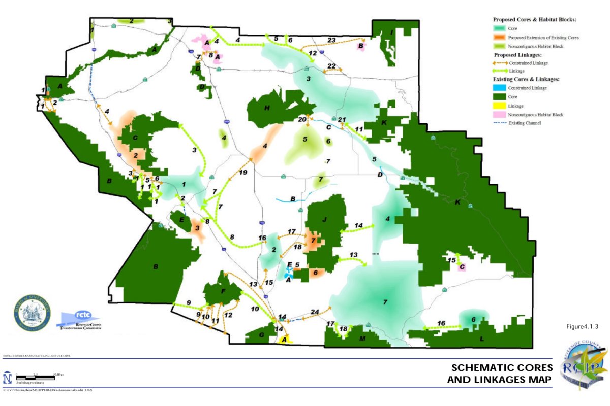
The proposed Plan provides for the movement of native resident and migratory species and protects established wildlife corridors and genetic flow. The Plan also protects the use of native wildlife nursery sites. Therefore, impacts related to cores and linkages resulting from the Plan are considered to be less than significant.
| Table 4E - Summary of Impacts to Cores and Linkages | |||||
|---|---|---|---|---|---|
| Proposed MSHCP | Listed, Proposed, and Strong Candidate Species Alternative |
Listed and Proposed Species Alternative |
Existing Reserves Alternative |
No Project Alternative |
|
| Existing Core A | In | In | In | In | In |
| Existing Core B | In | In | In | In | In |
| Existing Core C | In | In | In | In | In |
| Existing Core D | In | In | In | In | In |
| Existing Core E | In | In | In | In | In |
| Existing Core F | In | In | In | In | In |
| Existing Core G | In | In | In | In | In |
| Existing Core H | In | In | In | In | In |
| Existing Core I | In | In | In | In | In |
| Existing Core J | In | In | In | In | In |
| Existing Core K | In | In | In | In | In |
| Existing Core L | In | In | In | In | In |
| Existing Core M | In | In | In | In | In |
| Existing Noncontiguous Habitat Block A | In | In | In | In | In |
| Existing Noncontiguous Habitat Block B | In | In | In | In | In |
| Existing Noncontiguous Habitat Block C | In | In | In | In | In |
| Existing Linkage A | In | In | In | In | In |
| Existing Constrained Linkage A | In | In | In | In | In |
| Existing Constrained Linkage B | In | In | In | In | In |
| Existing Constrained Linkage C | In | In | In | In | In |
| Existing Constrained Linkage D | In | In | In | In | In |
| Existing Constrained Linkage E | In | In | In | In | In |
| Proposed Core 1 | In | In | In | Out | Out |
| Proposed Core 2 | In | In | In | Out | Out |
| Proposed Core 3 | In | 1 | Out | Out | Out |
| Proposed Core 4 | In | Out | Out | Out | Out |
| Proposed Core 5 | In | In | In | Out | Out |
| Proposed Core 6 | In | 2 | 2 | Out | Out |
| Proposed Core 7 | In | 3 | 3 | Out | Out |
| Proposed Extension of Existing Core 1 | In | Out | Out | Out | Out |
| Proposed Extension of Existing Core 2 | In | 4 | 4 | Out | Out |
| Proposed Extension of Existing Core 3 | In | Out | Out | Out | Out |
| Proposed Extension of Existing Core 4 | In | In | In | Out | Out |
| Proposed Extension of Existing Core 5 | In | Out | Out | Out | Out |
| Proposed Extension of Existing Core 6 | In | In | In | Out | Out |
| Proposed Extension of Existing Core 7 | In | Out | Out | Out | Out |
| Proposed Noncontiguous Habitat Block 1 | In | In | In | Out | Out |
| Proposed Noncontiguous Habitat Block 2 | In | Out | Out | Out | Out |
| Proposed Noncontiguous Habitat Block 3 | In | Out | Out | Out | Out |
| Proposed Noncontiguous Habitat Block 4 | In | In | In | Out | Out |
| Proposed Noncontiguous Habitat Block 5 | In | In | Out | Out | Out |
| Proposed Noncontiguous Habitat Block 6 | In | In | In | Out | Out |
| Proposed Noncontiguous Habitat Block 7 | In | In | In | Out | Out |
| Proposed Linkage 1 | In | Out | Out | Out | Out |
| Proposed Linkage 2 | In | In | In | Out | Out |
| Proposed Linkage 3 | In | In | In | Out | Out |
| Proposed Linkage 41 | In | Reduced | Out | Out | Out |
| Proposed Linkage 5 | In | In | In | Out | Out |
| Proposed Linkage 6 | In | Out | Out | Out | Out |
| Proposed Linkage 7 | In | Out | Out | Out | Out |
| Proposed Linkage 8 | In | In | In | Out | Out |
| Proposed Linkage 9 | In | Out | Out | Out | Out |
| Proposed Linkage 10 | In | Reduced | Reduced | Out | Out |
| Proposed Linkage 11 | In | Out | Out | Out | Out |
| Proposed Linkage 12 | In | 5 | 5 | Out | Out |
| Proposed Linkage 13 | In | Out | Out | Out | Out |
| Proposed Linkage 14 | In | Out | Out | Out | Out |
| Proposed Linkage 15 | In | Out | Out | Out | Out |
| Proposed Linkage 16 | In | In | Out | Out | Out |
| Proposed Linkage 17 | In | Out | Out | Out | Out |
| Proposed Linkage 18 | In | In | In | Out | Out |
| Proposed Constrained Linkage 1 | In | Out | Out | Out | Out |
| Proposed Constrained Linkage 2 | In | Out | Out | Out | Out |
| Proposed Constrained Linkage 3 | In | In | In | Out | Out |
| Proposed Constrained Linkage 4 | In | 6 | 6 | Out | Out |
| Proposed Constrained Linkage 5 | In | In | In | Out | Out |
| Proposed Constrained Linkage 6 | In | 4 | 4 | Out | Out |
| Proposed Constrained Linkage 7 | In | Out | Out | Out | Out |
| Proposed Constrained Linkage 8 | In | In | In | Out | Out |
| Proposed Constrained Linkage 9 | In | Out | Out | Out | Out |
| Proposed Constrained Linkage 10 | In | Out | Out | Out | Out |
| Proposed Constrained Linkage 11 | In | Out | Out | Out | Out |
| Proposed Constrained Linkage 12 | In | Out | Out | Out | Out |
| Proposed Constrained Linkage 13 | In | In | In | Out | Out |
| Proposed Constrained Linkage 14 | In | In | In | Out | Out |
| Proposed Constrained Linkage 15 | In | Out | Out | Out | Out |
| Proposed Constrained Linkage 16 | In | In | In | Out | Out |
| Proposed Constrained Linkage 17 | In | Out | Out | Out | Out |
| Proposed Constrained Linkage 18 | In | Out | Out | Out | Out |
| Proposed Constrained Linkage 19 | In | In | In | Out | Out |
| Proposed Constrained Linkage 20 | In | Out | Out | Out | Out |
| Proposed Constrained Linkage 21 | In | In | In | Out | Out |
| Proposed Constrained Linkage 22 | In | Out | Out | Out | Out |
| Proposed Constrained Linkage 23 | In | Out | Out | Out | Out |
| Proposed Constrained Linkage 24 | In | In | In | Out | Out |
| Notes: 1 Reduced to focus on Reche Canyon and Gilman Springs. 2 Reduced to focus on Silverado Area. 3 Reduced to focus on Vail Lake, Temecula Creek, and Wilson Creek. 4 Reduced to focus on Temescal Wash. 5 Reduced to focus on San Timoteo Creek. 6 Reduced to focus on Listed, Proposed, and Strong Candidate Species in Temescal Wash. |
|||||
Relationship to Adopted or Approved HCPs or NCCPs. As shown in Figure 4.1.2, Regional MSHCP Context, the Additional Reserve Lands and existing public/quasipublic lands do not conflict with the provisions of any adopted Habitat Conservation Plan, Natural Community Conservation Plan, or other approved local, regional, or State habitat conservation plan, either within the MSHCP Plan Area or in the surrounding region. Rather, the MSHCP will complement other regional planning efforts, including those that are currently underway but have not yet been approved.
The discussion below describes the public and private lands that will provide connection to regional conservation planning adjacent to the MSHCP Area in the different alternative scenarios, and the extent to which the MSHCP will incorporate the missing linkages in the South Coast Ecoregion described in the California Wilderness Coalition Report.
San Bernardino Preliminary MSHCP Planning Area. The northern border of the Plan Area will continue to provide conservation planning in the Santa Ana River and the San Bernardino National Forest (Existing Cores A and I, respectively). In addition to those existing cores, Proposed Linkages 6, 5, and 4, and Proposed Noncontiguous Habitat Blocks 1, 2, and 3 are proposed in the northern border of the Plan Area. These existing and proposed cores and linkages provide connection to the San Bernardino Preliminary MSHCP Planning Area to the North.
Coachella Valley MSHCP Alternative 2. In the eastern border of the MSHCP Area, connection to the Coachella Valley MSHCP Alternative 2 is provided through San Bernardino National Forest and Anza-Borrego Desert State Park (Existing cores K and L, respectively).
San Diego MSCP North County Subarea and MHCOSP. Beauty Mountain Management Area (BLM land), Agua Tibia Mountain Wilderness Area, Santa Margarita Ecological Reserve, and the Cleveland National Forest will continue to be managed for biological resources and will provide connection to the MHCOSP and San Diego MSCP North County Subarea to the south of the MSHCP Area (Existing Cores L, M, G, and B, respectively). A parcel of BLM-owned land (Existing Linkage A), may be used to move from Pechanga Creek south into San Diego County, and Proposed Core 7 will also provide connection south into the MHCOSP through a mosaic of upland and wetland habitat. Proposed Constrained Linkages 9, 10, 11, and 12 connect the Santa Rosa Plateau and Tenaja Corridor to San Diego MSCP North County Subarea to the south, and Proposed Linkage 9 will also provide connection to the Cleveland National Forest in San Diego County.
Orange County Proposed Southern, and Central and Coastal Subregion NCCP Planning Area. The MSHCP provides connection into the Southern and Central and Coastal Subregion NCCP Planning Areas to the west through the Cleveland National Forest (Existing Core B). However, in the southwestern corner of the MSHCP Area is a small piece of land designated as “rural mountainous” surrounded by Cleveland National Forest to the north and east, with the proposed Orange County Southern Subregion NCCP Planning Area to the west. This small piece of land is not proposed to be part of the MSHCP Additional Reserve Lands and does not provide connection to surrounding regional conservation planning. As the Orange County Southern Subregion NCCP is developed, the location of this land should be taken in to account by all affected planning agencies.
Missing Linkages in the California Wilderness Coalition Report. The Proposed MSHCP has incorporated the missing linkages identified in the California Wilderness Coalition Report.
Edge Effects. An edge effect is defined as a change in the “conditions or species composition within an otherwise uniform habitat as one approaches a boundary with a different habitat” (Ricklefs, 1993). Edge effects at the boundary between natural lands and human-occupied lands (“urban edge effects”) arise due to human-related intrusions such as lighting, noise, invasive species, exotic predators (e.g., dogs, cats, and opossums), hunting, trapping, off-road activities, dumping, and other forms of recreation and disturbance. Although some species are in some ways unaffected by edges -- for example, reproductive output of the rufous-crowned sparrow (Morrison and Bolger, 2002), distribution of arthropod species (Bolger, et al., 2000) - or even show preferences for edges - for example, indigo buntings and northern cardinals in Woodward, et al. (2001) - human-induced edge effects are generally unfavorable to native species.
Edge effects could occur to species and habitats within the MSHCP Conservation Area if proposed land uses and activities in take authorized areas occur in proximity to the MSHCP Conservation Area. Edge effects may be short-term effects related to construction or long-term effects associated with development or land use practices in proximity to Conserved Habitat areas. For the Proposed Action, it is assumed that edge effects resulting from construction activities include dust, noise, and general human It is assumed that edge effects resulting from development or land use practices in proximity to Conserved Habitat areas include long-term presence of unshielded noise-generating land uses in proximity to the MSHCP Conservation Area; unshielded night-lighting directed within the MSHCP Conservation Area; use of exotic landscape plant materials that may invade native vegetation communities within the MSHCP Conservation Area; discharge of uncontrolled or unfiltered urban runoff toward the MSHCP Conservation Area, including potential toxics; and uncontrolled access, dumping or trespass within the MSHCP Conservation Area.
For those cores and linkages with higher perimeter-to-area ratios, as identified in Table 4E, edge effects would be considered to have a greater effect on Conserved Habitat and Covered Species than for the larger cores and linkages incorporated in the MSHCP Conservation Area.
As noted in the discussions of Impacts to cores and linkages and Impacts Related to Covered Activities, a variety of features have been incorporated into the proposed MSHCP that will minimize edge effects. These include the following:
- Implementation of standard BMPs (Appendix C of the MSHCP);
- Implementation of the Land Use Guidelines Pertaining to the Urban/Wildlands Interface (Section 6.1.4 of the MSHCP); and
- Implementation of the siting, design, construction, operations, and maintenance guidelines for Covered Activities within the Criteria Area and Allowable Uses within the MSHCP Conservation Area (Section 7.0 of the MSHCP).
With these features incorporated, the MSHCP's edge effects are less than significant.
Listed, Proposed, and Strong Candidate Species Alternative
Vegetation Communities. For sensitive upland communities within the MSHCP Area, implementation of this alternative would authorize take of 43 percent of the chaparral, 53 percent of the coastal sage scrub, 90 percent of the desert scrub, 75 percent of the grassland (including native and non-native grassland), and 44 percent of the Riversidean alluvial fan sage scrub (Table 4F). For wetland communities within the MSHCP Area, this alternative would authorize take of 81 percent of the meadows and marshes, 26 percent of the playas and vernal pools, 17 percent of water, and 38 percent of the riparian scrub, woodland and forest. For forest communities within the MSHCP Area, this alternative would authorize take of 31 percent of the montane coniferous forest, and 35 percent of the woodlands and forests. In addition, 84 percent of the agricultural land in the Plan Area would be authorized for take by implementation of this alternative.
| Table 4F - Summary of Impacts to Vegetation Communities1 | |||||
|---|---|---|---|---|---|
| Vegetation Type | Total Acres in Plan Area | Proposed MSHCP Total Acres / % Within the Area Subject to Take Authorization |
Listed, Proposed, and Strong Candidate Species Alternative Total Acres / % Within the Area Subject to Take Authorization |
Listed and Proposed Species Alternative Total Acres / % Within the Area Subject to Take Authorization |
Existing Reserves Total Acres / % Within the Area Subject to Take Authorization |
| Agriculture | 169,480 | 149,460/88% | 143,100/84% | 143,100/84% | 158,000/93% |
| Chaparral | 434,950 | 162,670/37% | 187,960/43% | 200,560/46% | 227,570/52% |
| Coastal Sage Scrub | 156,450 | 74,730/48% | 82,71053% | 92,060/59% | 121,890/78% |
| Desert Scrub | 14,570 | 9,580/66% | 13,100/90% | 13,260/91% | 13,260/91% |
| Grassland | 154,140 | 111,320/72% | 116,110/75% | 120,120/78% | 131,330/85% |
| Meadows and Marshes2 | 2,280 | 1,730/76% | 1,850/81% | 1,870/82% | 1,950/86% |
| Montane Coniferous Forest | 29,910 | 9,410/31% | 9,400/31% | 9,400/31% | 9,430/31% |
| Playas and Vernal Pools | 7,910 | 1,160/15% | 2,060/26% | 2,060/26% | 4,990/63% |
| Riparian Scrub, Woodland and Forest | 15,030 | 3,840/26% | 5,660/38% | 5,960/40% | 7,760/52% |
| Riversidean Alluvial Fan Sage Scrub | 7,940 | 2,710/34% | 3,500/44% | 3,520/44% | 5,880/74% |
| Unknown | 1,350 | 110/8% | 110/8% | 110/8% | 120/9% |
| Water | 12,210 | 1,870/15% | 2,120/17% | 2,200/18% | 3,060/25% |
| Woodlands and Forests | 34,300 | 10,80032% | 11,780/34% | 11,940/35% | 13,530/39% |
| Developed or Disturbed Land | 218,260 | - - | - - | - - | - - |
| TOTALS | 1,258,780 | 539,3903 | 579,4703 | 606,1603 | 698,7703 |
| Notes: 1 Impacts associated with the No Project Alternative are presented separately. 2 Includes cismontane alkali marsh. 3 Totals exclude developed/disturbed land, because no additional impact to biological resources would occur in these areas as a result of implementation of the Proposed MSHCP or alternatives. Source: Western Riverside County MSHCP, November 2002. |
|||||
Certain features incorporated in the MSHCP would minimize impacts to sensitive vegetation communities. These include assembly of an approximately 477,000-acre MSHCP Conservation Area encompassing Conserved Habitat. Conserved Habitat is defined as land that is permanently protected and managed for the benefit of the Covered Species under this alternative under legal arrangements that prevent its conversion to other uses. The acreages of vegetation communities not authorized for take under this alternative would be included as Conserved Habitat within the MSHCP Conservation Area. For the sensitive upland communities, inclusion of 57 percent of the chaparral within the MSHCP Conservation Area under this alternative would reduce identified impacts to these communities to a level below significance given the large percentage of this vegetation community to be included as Conserved Habitat under this alternative, the extensive acreage and wide distribution of this vegetation community in the Plan Area, and the relatively low numbers of listed species preferring this vegetation community within the Plan Area. For Riversidean alluvial fan sage scrub, although 56 percent of this vegetation community would be included as Conserved Habitat under this alternative, significant impacts to Riversidean alluvial fan sage scrub would remain due to the patchy distribution of this vegetation community in the Plan Area and the relatively large numbers of sensitive species occurring in this vegetation community. Due to the large percentages of coastal sage scrub (53%), grassland (75%) (including native and non-native grassland), and desert scrub (90%) potentially within the area subject to take authorization within the take authorized area under this alternative, significant impacts to these vegetation communities would occur even with application of the minimization measures. With respect to agriculture, although the proposed take authorization under this alternative would apply to 84 percent of this vegetation community, this vegetation community is not a sensitive natural community, so impacts to agriculture are not considered biologically significant. (As noted previously, impacts to agriculture are analyzed in Section 4.2, and impacts to species that utilize agricultural lands have been analyzed in the discussions of impacts to Listed Covered Species and impacts to Non-Listed Covered Species.)
In addition, Section 6.1.2 of the MSHCP discusses mapping of riparian, riverine, vernal pools, and other potentially jurisdictional wetland areas as part of review of applications for Covered Activities within the MSHCP Area. The policy calls for avoidance and minimization of impacts to wetland habitat throughout the Plan Area in accordance with existing regulatory standards that call for no net loss of wetland functions and values. Together, inclusion of substantial acreages of wetland vegetation communities within the MSHCP Conservation Area under this alternative, and implementation of the policy related to riparian, riverine, and vernal pool areas incorporated in the MSHCP, would reduce identified impacts to wetland vegetation communities to a level below significance.
Listed Covered Species. The Listed, Proposed, and Strong Candidate Species Alternative encompasses approximately 466,000 acres, comprising 347,000 acres of public/quasipublic land and 119,000 acres of Additional Reserve Lands, and conserves portions of all vegetation communities distributed throughout the MSHCP Area. Representative vegetation communities from the seven bioregions in the Plan Area are conserved under this scenario. None of the land cover types identified on the vegetation map as developed or disturbed are proposed for conservation.
As a result of issuance of a 10(a) permit, the listed species identified in Table 4B could be legally taken by permitted jurisdictions where they occur outside of the MSHCP Conservation Area. The list of Listed Covered Species for this alternative is the same as for the MSHCP Project. The Listed Covered Species would be directly affected by the take authorization because they will no longer receive protection outside of the MSHCP Conservation Area. The impacts to the 32 Listed Covered Species are quantified based on the best existing information available for known occurrences and potential suitable habitat for each Listed Covered Species (Table 4B).
Covered activities under this alternative would be identical to those described for the MSHCP. Therefore, the impacts to Listed Covered Species associated with Covered Activities, including development of single-family homes or location of mobile homes on existing legal parcels and conversion of natural lands to agricultural use (as defined However, the impacts of this alternative would be generally much greater in magnitude when compared to the proposed MSHCP. For example, loss of suitable habitat for southwestern willow flycatcher would be 4,735 acres (34%) under this alternative, and the loss of suitable habitat under the proposed MSHCP would be approximately 3,220 acres (23%) (Table 4B). For certain Listed Covered Species, such as Delhi Sands flower-loving fly and Munz's onion, the precise quantity of the impact is undetermined at this time due to lack of existing available information regarding these species.
Features are incorporated into the Listed, Proposed, and Strong Candidate Species Alternative to minimize impacts to Listed Covered Species. These include assembly of an MSHCP Conservation Area that incorporates substantial acreages of suitable habitat and known locations in a configuration that provides live-in and linkage habitat for a number of species. For example, core populations of coastal California gnatcatcher at Alberhill, North Peak, Kabian Park, and Ramsgate would be conserved, as well as linkages, such as the Sedco Hills and Gavilan Plateau, to other localities in the MSHCP Area. Criteria-based Reserve Assembly would occur in a manner consistent with Rough Step policies and the Habitat Evaluation and Acquisition Negotiation Process described in Section 6.1.1, MSHCP, Volume I.
In addition, this alternative includes policies that would afford some Listed Covered Species occurring outside of the MSHCP Conservation Area additional protection. The narrow endemics plant species policy and the additional survey needs policy, described in Section 6.1.3 and 6.3.2, respectively, of the MSHCP, Volume I, require surveys to be conducted as part of the project review process for public and private projects where suitable habitat is present. The following Listed Covered Species are subject to the narrow endemic plant species and additional survey needs policies.
Narrow Endemic Plant Species Policy
| Munz's onion San Diego ambrosia San Jacinto Valley crownscale Nevin's barberry thread-leaved brodiaea |
Vail Lake ceanothus slender-horned spine flower spreading navarretia California Orcutt grass |
Additional Survey Needs Policy
| western yellow-billed cuckoo southwestern willow flycatcher |
least Bell's vireo San Bernardino kangaroo rat |
Species detected during surveys would be conserved in accordance with the respective applicable policy. Information gathered as a result of species surveys would serve to fill data gaps and inform monitoring and management for a species. The additional survey requirements and information gathering efforts would be implemented until the MSHCP Conservation Area is assembled in a manner that provides for long-term conservation of these species.
Wetland species occurring outside of the MSHCP Conservation Area may also receive additional protection as a result of implementation of the policy related to riparian, riverine, and vernal pool areas, described in Section 6.1.2 of the MSHCP, Volume I. As part of the wetland policy, survey, mapping and documentation of riparian, riverine, vernal pool systems, and other areas that are identified as jurisdictional under Section 1600 et seq. of the California Fish and Game Code or Sections 401, 402, or 404 of the Federal Clean Water Act would occur. These areas may include playas and vernal pools, open water, meadows and marshes, riparian scrub, woodlands and forests, and other habitat types, known to occur in the Plan Area. For mapped resources that are located outside of the MSHCP Conservation Area, wetlands avoidance and minimization measures, consistent with existing regulations, would be employed. The avoidance and minimization measures would reduce impacts to wetland habitats supporting Listed Covered Species. The following Listed Covered Species would benefit from implementation of the policy related to riparian, riverine, and vernal pool areas.
Listed Covered Wetland Species
| vernal pool fairy shrimp Riverside fairy shrimp Santa Ana sucker arroyo toad California red-legged frog mountain yellow-legged frog western yellow-billed cuckoo southwestern willow flycatcher |
peregrine falcon bald eagle least Bell's vireo California Orcutt grass San Jacinto Valley crownscale thread-leaved brodiaea San Diego button-celery spreading navarretia |
If suitable habitat were determined to be present, focused surveys for the following Listed Covered Species would be conducted: least Bell's vireo, southwestern willow flycatcher, western yellow-billed cuckoo, vernal pool fairy shrimp, and Riverside fairy shrimp. Localities of wetland species observed during focused surveys would be conserved in accordance with wetland conservation policies contained in Section 6.1.2 of the MSHCP.
A reduced level of conservation of suitable habitat and species localities at Temescal Wash, Vail Lake, Temecula Creek, Wilson Creek, Anza Valley, Badlands, and Reche Canyon is anticipated under this alternative. Areas such as the Jurupa Mountain, Cactus Valley, and a number of linkages, including Warm Springs Creek, Tenaja Corridor, Tule Creek, Cahuilla Creek, Garden Aire Wash, and Noble Creek, previously identified for inclusion as part of the MSHCP Conservation Area, would be excluded under this alternative. However, with application of the narrow endemic policy, additional survey needs policy and wetlands policy, as well as reserve assembly and configuration, direct and indirect impacts to Listed Covered Species would be reduced to less than significant levels.
Non-listed Covered Species. Implementation of the Listed, Proposed, and Strong Candidate Species Alternative would result in direct and indirect impacts to Non-Listed Covered Species. The Non-Listed Covered Species for the Listed, Proposed and Strong Candidate Species Alternative include those species identified in Table 4G.
| Table 4G - Non-listed Species Covered Under the Listed, Proposed, and Strong Candidate Species Alternative | |
|---|---|
| Invertebrates/Crustaceans | |
| Santa Rosa Plateau fairy shrimp | |
| Fish | |
| arroyo chub | |
| Amphibians | |
| coast range newt | |
| Reptiles | |
| orange-throated whiptail | San Diego banded gecko |
| coastal western whiptail | San Diego horned lizard |
| granite night lizard | San Diego mountain kingsnake |
| granite spiny lizard | southern sagebrush lizard |
| northern red-diamond rattlesnake | western pond turtle |
| San Bernardino mountain kingsnake | |
| Birds | |
| American bittern | mountain quail |
| black swift | Nashville warbler |
| black-crowned night heron | northern goshawk |
| burrowing owl | osprey |
| cactus wren | purple martin |
| California horned lark | sharp-shinned hawk |
| California spotted owl | Southern California rufous-crowned sparrow |
| Cooper's hawk | tree swallow |
| double-breasted cormorant | tricolored blackbird |
| downy woodpecker | turkey vulture |
| ferruginous hawk | white-faced ibis |
| Lincoln's sparrow | Williamson's sapsucker |
| loggerhead shrike | Wilson's warbler |
| Macgillvray's warbler | yellow warbler |
| merlin | yellow-breasted chat |
| Mammals | |
| brush rabbit | northwestern San Diego pocket mouse |
| coyote | San Bernardino flying squirrel |
| Los Angeles pocket mouse | |
| Plants | |
| beautiful hulsea | many-stemmed dudleya |
| California beardtongue | Munz's mariposa lily |
| California bedstraw | ocellated Humboldt lily |
| California black walnut | Orcutt's brodiaea |
| California muhly | Palmer's grapplinghook |
| chickweed oxytheca | Palomar monkeyflower |
| Cleveland's bush monkeyflower | Parish's brittlescale |
| cliff cinquefoil | Parry's spine flower |
| Coulter's goldfields | Payson's jewelflower |
| Coulter's matilija poppy | peninsular spine flower |
| Davidson's saltscale | Plummer's mariposa lily |
| Engelmann oak | prostrate spine flower |
| Fish's milkwort | Rainbow manzanita |
| graceful tarplant | San Jacinto Mountains bedstraw |
| Hall's monardella | San Miguel savory |
| heart-leaved pitcher sage | shaggy-haired alumroot |
| intermediate mariposa lily | small-flowered microseris |
| Jaeger's milk-vetch | small-flowered morning glory |
| Johnston's rock cress | smooth tarplant |
| lemon lily | sticky-leaved dudleya |
| little mousetail | vernal barley |
| long-spined spine flower | Wright's trichocoronis |
The species identified in Table 4G could be legally taken by permitted jurisdictions where they occur outside of the MSHCP Conservation Area. The impacts to the Non-Listed Covered Species are quantified based on the best existing information available for known occurrences and potential suitable habitat for each Non-Listed Covered Species (the analysis summary for these species is contained in Table 4C).
Covered activities under this alternative would be identical to those described for the MSHCP. Therefore, the impacts to Non-Listed Covered Species associated with Covered Activities, including development of single-family homes or location of mobile homes on existing legal parcels and conversion of natural lands to agricultural use (as defined and outlined in Section 6.3 of the MSHCP, if implemented) within the Criteria Area, are the same as they are for the MSHCP.
The impacts of this alternative would be generally much greater in magnitude when compared to the proposed MSHCP. For example, loss of suitable habitat for yellow-breasted chat would be 4,085 acres (33%) under this alternative, and the loss of suitable habitat under the proposed MSHCP would be approximately 2,780 acres (22%) (Table 4C). For certain Non-Listed Covered Species, such as arroyo chub and San Bernardino flying squirrel, the precise quantification of the impact is undetermined at this time due to lack of existing available information regarding these species.
Features are incorporated into the Listed, Proposed, and Strong Candidate Species Alternative to minimize impacts to Non-Listed Covered Species. These include assembly of an MSHCP Conservation Area that incorporates substantial acreages of suitable habitat and known locations in a configuration that provides live-in and linkage habitat for a number of species. For example, core populations of Bell's sage sparrow at Lake Skinner/Diamond Valley Lake, Aguanga, and the Jurupa Mountains, would be conserved, as well as linkages, such as the Sedco Hills and Hogbacks, to other localities in the Plan Area. Criteria-based Reserve Assembly would occur in a manner consistent with Rough Step policies and the Habitat Evaluation and Acquisition Negotiation Process described in Section 6.1.1, MSHCP, Volume I.
In addition, this alternative includes policies that would afford some Non-Listed Covered Species occurring outside of the MSHCP Conservation Area additional protection. The narrow endemics plant species policy and the additional survey needs policy, described in Section 6.1.3 and 6.3.2, respectively, of the MSHCP, Volume I, require surveys to be conducted as part of the project review process for public and private projects where suitable habitat is present. The following Non-Listed Covered Species are subject to the narrow endemic plant species and additional survey needs policies.
Narrow Endemic Plant Species Policy
| Johnston's rock-cress Munz's mariposa lily many-stemmed dudleya |
San Jacinto Mountains bedstraw San Miguel savory Wright's trichocoronis |
Additional Survey Needs Policy
| burrowing owl Los Angeles pocket mouse smooth tarplant Coulter's goldfields |
little mousetail Parish's brittlescale Nevin's barberry |
Species detected during surveys would be conserved in accordance with the respective applicable policy. Information gathered as a result of species surveys would serve to fill data gaps and inform monitoring and management for a species. The additional survey requirements and information gathering efforts would be implemented until the MSHCP Conservation Area is assembled in a manner that provides for long-term conservation of these species.
Wetland species occurring outside of the MSHCP Conservation Area may also receive additional protection as a result of implementation of the policy related to riparian, riverine, and vernal pool areas, described in Section 6.1.2 of the MSHCP, Volume I. As part of this policy, survey, mapping and documentation of riparian, riverine, vernal pool systems, and other areas that are identified as jurisdictional under Section 1600 et seq. of the California Fish and Game Code and Sections 401, 402, and 404 of the Federal Clean Water Act would occur. These areas may include playas and vernal pools, open water, meadows and marshes, riparian scrub, woodlands and forests, and other habitat types, known to occur in the Plan Area. For mapped habitat located outside of the MSHCP Conservation Area, avoidance and minimization measures, consistent with existing regulations, would be employed. The avoidance and minimization measures would reduce impacts to wetland habitats supporting a number of Non-Listed Covered Species. The following Non-Listed Covered Species would benefit from implementation of this policy.
Non-Listed Covered Wetland Species
| coast range newt American bittern black-crowned night-heron black swift (breeding) Cooper's hawk double-crested cormorant Lincoln's sparrow breeding Macgillvray's warbler Nashville warbler osprey purple martin tree swallow tricolored blackbird white-faced ibis Wilson's warbler |
yellow warbler yellow-breasted chat arroyo chub Santa Rosa Plateau fairy shrimp California muhly Coulter's goldfields Davidson's saltscale little mousetail Orcutt's brodiaea Parish's brittlescale Parish's meadowfoam vernal barley Wright's trichocoronis western pond turtle |
If suitable habitat were determined to be present, focused surveys for the Santa Rosa Plateau fairy shrimp would be conducted. Localities of wetland species observed during focused surveys would be conserved in accordance with wetland conservation policies contained in Section 6.1.2 of the MSHCP.
A reduced level of conservation of suitable habitat and species localities at Temescal Wash, Vail Lake, Temecula Creek, Wilson Creek, Anza Valley, Badlands, and Reche Canyon is anticipated under this alternative. Areas such as the Jurupa Mountain, Cactus Valley, and a number of linkages, including Warm Springs Creek, Tenaja Corridor, Tule Creek, Cahuilla Creek, Garden Aire Wash, and Noble Creek, previously identified for inclusion as part of the MSHCP Conservation Area, would be excluded under this alternative. However, adequate conservation for the Non-Listed Covered Species is provided with this alternative. It should be noted that certain species that are covered under the MSHCP Project are not covered under this alternative.
Non-Covered Species. The list of defined Non-Covered Species for the Listed, Proposed, and Strong Candidate Species Alternative is presented in Table 4H. Any conservation benefits that would accrue to these species as a result of the MSHCP project would be reduced under this alternative, due to the reduction in overall Conservation Area. However, as noted, it is not possible to fully quantify the potential adverse effects to Non-Covered Species at this time due to the lack of information for these species. Please also refer to discussion of impacts to non-covered species for the proposed MSHCP. Impacts to non-covered species, including impacts resulting from Covered Activities, are therefore assumed to be potentially significant and not mitigable.
| Table 4H - Non-Covered Species Under the Listed, Proposed, and Strong Candidate Species Alternative | |
|---|---|
| Invertebrates/Insects | |
| Electra silkmoth | Ruth's cuckoo bee |
| Frost's tiger beetle | San Jacinto blue butterfly |
| Greenest tiger beetle | Simple hydroporus diving beetle |
| Harbisons dun skipper | |
| Fish | |
| speckled dace | |
| Amphibians | |
| large-blotched salamander | western spadefoot |
| Reptiles | |
| California legless lizard | long-nosed leopard lizard |
| California red-sided garter snake | San Bernardino ringneck snake |
| coast patch-nosed snake | San Diego ringneck snake |
| coastal glossy snake | two-striped garter snake |
| Birds | |
| Bell's sage sparrow | northern harrier |
| California black rail | northern pygmy owl |
| flammulated owl | prairie falcon |
| golden eagle | short-eared owl |
| grasshopper sparrow | Swainson's thrush |
| great blue heron | Vaux's swift |
| greater sandhill crane | western least bittern |
| Le Conte's thrasher | western snowy plover |
| long-eared owl | white-tailed kite |
| Mammals | |
| Aguanga kangaroo rat | Nelson's bighorn sheep |
| American badger | pale big-eared bat |
| big free-tailed bat | pallid bat |
| bobcat | peninsular bighorn sheep |
| California leaf-nosed bat | pocketed free-tailed bat |
| California mastiff bat | ringtail |
| Dulzura California pocket mouse | San Diego black-tailed jackrabbit |
| Dulzura kangaroo rat | San Diego desert woodrat |
| fringed myotis | southern grasshopper mouse |
| long-eared myotis | southern yellow bat |
| long-legged myotis | spotted bat |
| long-tailed weasel | western big-eared bat |
| Mexican long-tongued bat | western small-footed myotis |
| mountain lion | |
| Plants | |
| adder's mouth | Parish's onion |
| ayenia | Parish's rupertia |
| Big Bear Valley woollypod | Parry's tetracoccus |
| bluish spike moss | prairie wedge grass |
| Brand's phacelia | Pringle's monardella |
| Braunton's milk-vetch | prostrate navarretia |
| California spine-flower | Robinson's pepper grass |
| caraway-leaved gilia | round-leaved boykinia |
| chocolate lily | round-leaved filaree |
| cliff spurge | sagebrush loeflingia |
| coastal dunes milk-vetch | salt spring checkerbloom |
| Coulter's saltbush | San Bernardino Mountains owl clover |
| crested milk-vetch | San Diego goldenstar |
| Davidson's stonecrop | San Jacinto beardtongue |
| desert sage | San Jacinto Mountain daisy |
| Duran's rush | San Jacinto prickly phlox |
| Hammitt's clay-cress | San Jacinto Valley crownscale |
| Hidden Lake bluecurl | Santa Rosa Mountains linanthus |
| jackass clover | Santiago Peak keckii |
| Laguna Mountains jewel-flower | slender bedstraw |
| Lakeside ceanothus | small-flowered bluecurls |
| leafy buckwheat | snake cholla |
| Lemmon's syntrichopappus | Sonoran maiden form |
| light-gray lichen | South coast saltscale |
| Mission Canyon bluecup | southern skullcap |
| mud nama | southern jewel-flower |
| Orcutt's linanthus | summer holly |
| Palmer's mariposa lily | Tahquitz ivesia |
| panamint dudleya | Thurber's penstemon |
| Parish's alumroot | white-bracted spine flower |
| Parish's chaenactis | white-margined oxytheca |
| Parish's daisy | Yucaipa onion |
| Parish's desert thorn | Ziegler's aster |
Cores and Linkages. Under the Listed, Proposed, and Strong Candidate Species Alternative, all of the cores and linkages noted in Table 4E for this alternative would be incorporated into the MSHCP Conservation Area. As noted in the discussion of the Relationship to Adopted or Approved HCPs and NCCPS, these cores and linkages include most but not all of the missing links identified by the California Wilderness Coalition in its study of linkage priorities in the South Coast Ecoregion, for which the MSHCP has the ability to incorporate such cores and linkages. Table 4E also identifies the proposed cores and linkages that are not included as part of this alternative. Most notable is the exclusion of the constrained linkages from French Valley to Diamond Valley Lake/Lake Skinner (Proposed Constrained Linkages 17 and 18), the proposed linkages and core areas from Diamond Valley Lake/Lake Skinner to the San Jacinto Mountains and Wilson Valley (Proposed Linkage 13 and 14 and Proposed Cores 4 and 7) and the linkages from the Santa Rosa Plateau to Orange County (Proposed Linkage 9) and San Diego County (Proposed Constrained Linkages 9, 10, 11, and 12). Also reduced conservation would occur in the Badlands, Reche Canyon, Wilson Valley, Vail Lake, and Temecula Creek areas under this alternative.
Absence of these cores and linkages would have significant effects with respect to certain species, as well as overall function of the MSHCP Conservation Area. For example, the absence of the linkages from French Valley to the Diamond Valley Lake/Lake Skinner Reserve would affect movement by common mammals and avian species in this area and isolate populations of species occurring within the Diamond Valley Lake/Lake Skinner Reserve. The exclusion of Cactus Valley (Proposed Core 4) from the MSHCP Conservation Area would adversely affect the function of the MSHCP Conservation Area by not providing a connection from Diamond Valley Lake/Lake Skinner to National Forest Lands to the east. Absence of this linkage would isolate the existing multi-species reserve from existing conserved lands to the east. Take authorized in this area would adversely affect planning species identified for this Proposed Core, including Quino checkerspot butterfly. These effects are regarded as significant.
Assembly of the cores and linkages will occur in accordance with the reserve assembly process outlined in the MSHCP Plan, Volume I. However, the combination of constrained linkages and a less robust reserve design under this alternative may affect the ability of the cores and linkages to function. This is regarded as a significant effect.
Relationship to Adopted or Approved HCPs and NCCPs. The following discussion focuses on regional planning efforts. Significant impacts are anticipated due to the failure to maintain critical linkage components present in other adopted HCPs and NCCPs.
San Bernardino Preliminary MSHCP Planning Area. Connections to the San Bernardino Preliminary MSHCP Area to the north are generally the same as discussed for Proposed MSHCP with the exception that Proposed Noncontinuous Habitat Block 2 has been reduced in size, and Proposed Linkage 4 has been eliminated. Proposed Linkage 4 served to create missing linkage 36 in the California Wilderness Coalition Report. Elimination of this connection north into the San Bernardino Mountains could cause conflicts with regional conservation planning efforts, although the San Bernardino MSHCP is not yet adopted or approved.
Coachella Valley MSHCP Alternative 2. Impacts to connections to the Coachella Valley MSHCP area to the east are essentially the same as discussed for the Proposed MSHCP.
San Diego MSCP North County Subarea and MHCOSP. Impacts to connection to resource planning areas in San Diego County to the south are generally the same as discussed for the Proposed MSHCP; however, Proposed Linkage 9 is eliminated under this alternative. Proposed Linkage 9 serves as one of the missing linkages identified as a high priority linkage in the California Wilderness Coalition Report (linkage 55) providing connection to the southeast corner of Cleveland National Forest. Elimination of this linkage could cause conflicts with regional habitat conservation plans and is considered to be a significant impact.
Orange County Proposed Southern, and Central and Coastal Subregion NCCP Planning Area. Connections to the Orange County NCCP Planning Areas to the west are the same as discussed for the Proposed Project. Regional conservation planning impacts discussed under the Proposed MSHCP also apply to this alternative.
Missing Linkages in the California Wilderness Coalition Report. This alternative eliminates Proposed Extension of Existing Core 2. This core extension serves as missing linkage 45 identified in the California Wilderness Coalition Report connecting the Santa Ana Mountains to Lake Matthews. This alternative also eliminates Proposed Constrained Linkages 15 and 18. Proposed Constrained Linkages 15 and 18 serve as missing linkage 58 connecting Diamond Valley Lake to west of Temecula. Elimination of these missing linkages could cause conflicts to regional conservation planning and is considered to be a significant impact. In addition, elimination of the missing linkages discussed under connections north and south into San Bernardino and San Diego Counties, respectively, are also considered to be significant impacts under this alternative.
Edge Effects. The types of edge effects under this alternative would be the same as for the proposed MSHCP, and identified impacts would be minimized by the same features incorporated in the MSHCP as would occur under the proposed MSHCP. As noted in the discussion of impacts to cores and linkages under this alternative (and identified in Table 4E), certain cores and linkages identified for the proposed MSHCP would be reduced or absent from this alternative. For those cores and linkages absent from this alternative, no edge effects would occur. For those cores and linkages that would be reduced under this alternative, it is assumed that the perimeter-to-area ratios would be greater than under the proposed MSHCP. Edge effects to Conserved Habitat and Covered Species within these cores and linkages therefore would be greater under this alternative than would occur under the proposed MSHCP. Under this alternative, edge effects to sensitive species not included on the Covered Species list, but present within the reserve areas, would also occur.
The same features incorporated in the MSHCP to minimize edge effects would be incorporated in this alternative, including the standard BMPs; Land Use Guidelines Pertaining to the Urban/Wildlands Interface; and siting, design, construction, operations, and maintenance guidelines for Covered Activities and Allowable Uses. However, significant edge effects would remain even with implementation of these minimization measures because of the reduction in cores and linkages under this alternative when compared with the proposed MSHCP.
Listed and Proposed Species Alternative
Vegetation Communities. For sensitive upland communities within the MSHCP Area, implementation of this alternative would authorize take of 46 percent of the chaparral, 59 percent of the coastal sage scrub, 91 percent of the desert scrub, 78 percent of the grassland (including native and non-native grassland), and 44 percent of the Riversidean alluvial fan sage scrub (Table 4I). For wetland communities within the MSHCP Area, this alternative would authorize take of 82 percent of the meadows and marshes, 11 percent of the playas and vernal pools, 18 percent of water, and 40 percent of the riparian scrub, woodland and forest. For forest communities within the MSHCP Area, this alternative would authorize take of 31 percent of the montane coniferous forest, and 35 percent of woodlands and forests. In addition, 84 percent of the agricultural land in the Plan Area would be within the area subject to take authorization by implementation of this alternative.
Certain features incorporated in the MSHCP would minimize impacts to sensitive vegetation communities. These include assembly of an approximately 440,800-acre MSHCP Conservation Area encompassing Conserved Habitat. Conserved Habitat is defined as land that is permanently protected and managed for the benefit of the Covered Species under this alternative under legal arrangements that prevent its conversion to other uses. Under this alternative, to the extent the vegetation communities are not authorized for take, they would be included as Conserved Habitat within the MSHCP Conservation Area. For example, 31 percent of the montane coniferous forest would be in the take authorized area under this alternative, and 69 percent of the montane coniferous forest would be included in the MSHCP Conservation Area as Conserved Habitat. In general, inclusion of the majority of the forest communities as Conserved Habitat within the MSHCP Conservation Area under this alternative would reduce identified impacts to these communities to a level below significance.
For the sensitive upland communities, inclusion of 54 percent of the chaparral within the MSHCP Conservation Area under this alternative would reduce identified impacts to these communities to a level below significance given the large percentage of this vegetation community to be included as Conserved Habitat, the extensive acreage and wide distribution of this vegetation community in the Plan Area, and the relatively low numbers of listed species preferring this vegetation community within the Plan Area. For Riversidean alluvial fan sage scrub, although 56 percent of this vegetation community would be included as Conserved Habitat under this alternative, significant impacts to Riversidean alluvial fan sage scrub would remain due to the patchy distribution of this vegetation community in the Plan Area and the relatively large numbers of sensitive species occurring in this vegetation community. Due to the large percentages of coastal sage scrub (59%), grassland (78%) (including native and nonnative grassland), and desert scrub (91%) potentially within the area subject to take authorization within the take authorized area, significant impacts to these vegetation communities would occur even with application of the minimization measures. With respect to agriculture, although the proposed take authorization under this alternative would apply to 84 percent of this vegetation community, this vegetation community is not a sensitive natural community, so impacts to agriculture are not considered biologically significant. (As noted previously, impacts to agriculture are analyzed in Section 4.2, and impacts to species that utilize agricultural lands have been analyzed in the discussions of impacts to Listed Covered Species and impacts to Non-Listed Covered Species.)
| Table 4I - Summary of Impacts to Vegetation Communities1 | |||||
|---|---|---|---|---|---|
| Vegetation Type | Total Acres in Plan Area | Proposed MSHCP Total Acres / % Within the Area Subject to Take Authorization |
Listed, Proposed, and Strong Candidate Species AlternativeTotal Acres / % Affected Within the Area Subject to Take Authorization |
Listed and Proposed Species Alternative Total Acres / % Within the Area Subject to Take Authorization |
Existing Reserves Total Acres / % Within the Area Subject to Take Authorization |
| Agriculture | 169,480 | 149,460/88% | 143,100/84% | 143,100/84% | 158,000/93% |
| Chaparral | 434,950 | 162,670/37% | 187,960/43% | 200,560/46% | 227,570/52% |
| Coastal Sage Scrub | 156,450 | 74,730/48% | 82,71053% | 92,060/59% | 121,890/78% |
| Desert Scrub | 14,570 | 9,580/66% | 13,100/90% | 13,260/91% | 13,260/91% |
| Grassland | 154,140 | 111,320/72% | 116,110/75% | 120,120/78% | 131,330/85% |
| Meadows and Marshes2 | 2,280 | 1,730/76% | 1,850/81% | 1,870/82% | 1,950/86% |
| Montane Coniferous Forest | 29,910 | 9,410/31% | 9,400/31% | 9,400/31% | 9,430/31% |
| Playas and Vernal Pools | 7,910 | 1,160/15% | 2,060/26% | 2,060/26% | 4,990/63% |
| Riparian Scrub, Woodland and Forest | 15,030 | 3,840/26% | 5,660/38% | 5,960/40% | 7,760/52% |
| Riversidean Alluvial Fan Sage Scrub | 7,940 | 2,710/34% | 3,500/44% | 3,520/44% | 5,880/74% |
| Unknown | 1,350 | 110/8% | 110/8% | 110/8% | 120/9% |
| Water | 12,210 | 1,870/15% | 2,120/17% | 2,200/18% | 3,060/25% |
| Woodlands and Forests | 34,300 | 10,80032% | 11,780/34% | 11,940/35% | 13,530/39% |
| Developed or Disturbed Land | 218,260 | - - | - - | - - | - - |
| TOTALS | 1,258,780 | 539,3903 | 579,4703 | 606,1603 | 698,7703 |
| Notes: 1 Impacts associated with the No Project Alternative are presented separately. 2 Includes cismontane alkali marsh. 3 Totals exclude developed/disturbed land, because no additional impact to biological resources would occur in these areas as a result of implementation of the Proposed MSHCP or alternatives. Source: MSHCP. |
|||||
Section 6.1.2 of the MSHCP contains policies related to riparian, riverine, and vernal pool areas that call for mapping of riparian, riverine, vernal pools, and other potentially jurisdictional wetland areas as part of review of applications for Covered Activities within the MSHCP Area. The policy calls for avoidance and minimization of impacts to these areas throughout the Plan Area in accordance with existing regulatory standards. Together, inclusion of substantial acreages of wetland vegetation communities within the MSHCP Conservation Area under this alternative, and implementation of the riparian, riverine, and vernal pool policy incorporated in the MSHCP, would reduce identified impacts to wetland vegetation communities to a level below significance.
Listed Covered Species. The Listed and Proposed Species Alternative encompasses approximately 440,800 acres, comprising 440,800 acres of public/quasi-public land and 93,800 acres of Additional Reserve Lands, and conserves portions of all vegetation communities distributed throughout the MSHCP Area. Representative vegetation communities from the seven bioregions in the Plan Area are conserved under this scenario. No developed or disturbed habitats are proposed for conservation.
As a result of issuance of a 10(a) permit, the species identified in Table 4B could be legally taken by permitted jurisdictions where they occur outside of the MSHCP Conservation Area. The list of Listed Covered Species for this alternative is the same as for the proposed MSHCP. Likewise, the Covered Activities permitted under this alternative would be identical to those described for the MSHCP. Therefore, the impacts associated with Covered Activities would be the same as for the MSHCP.
The Listed Covered Species would be directly impacted by the alternative because they will no longer receive protection outside of the MSHCP Conservation Area. The impacts to the 32 Listed Covered Species are quantified based on the best existing information available for known occurrences and potential suitable habitat for each Listed Covered Species (Table 4B). The impacts of this alternative would be generally much greater in magnitude when compared to the proposed MSHCP. For example, loss of suitable habitat for southwestern willow flycatcher would be 4,990 acres (36%) under this alternative, while the loss of suitable habitat under the proposed MSHCP would be approximately 3,220 acres (23%). For certain Listed Covered Species, such as Munz's onion, the precise quantity of the impact is undetermined at this time due to lack of existing available information regarding these species.
Features are incorporated into the Listed and Proposed Species Alternative to minimize impacts to Listed Covered Species. These include assembly of a Conservation Area that incorporates substantial acreages of suitable habitat and known locations in a configuration that provides live-in and linkage habitat for a number of species. For example, core populations of coastal California gnatcatcher at Alberhill, North Peak, Kabian Park, and Ramsgate would be conserved, as well as linkages, such as the Sedco Hills and Gavilan Plateau, to other localities in the MSHCP Area. Criteria-based Reserve Assembly would occur in a manner consistent with Reserve Assembly process described in Section 6.1.1, MSHCP, Volume I.
Covered activities under this alternative would be identical to those described for the MSHCP. Therefore, the impacts to Listed Covered Species associated with Covered Activities, including development of single-family homes or location of mobile homes on existing legal parcels and conversion of natural lands to agricultural use (as defined and outlined in Section 6.3 of the MSHCP, if implemented) within the Criteria Area, are the same as they are for the MSHCP.
In addition, this alternative includes policies that would afford some additional protection to Listed Covered Species occurring outside of the MSHCP Conservation Area. The narrow endemics plant species policy and the additional survey needs policy, described in Sections 6.1.3 and 6.3.2, respectively, of the MSHCP, Volume I, require surveys to be conducted as part of the project review process for public and private projects where suitable habitat is present. The following Listed Covered Species are subject to the narrow endemic plant species and additional survey needs policies.
Narrow Endemic Plant Species Policy
| Munz's onion San Diego ambrosia San Jacinto Valley crownscale Nevin's barberry thread-leaved brodiaea |
Vail Lake ceanothus slender-horned spine flower spreading navarretia California Orcutt grass |
Additional Survey Needs Policy
| western yellow-billed cuckoo southwestern willow flycatcher |
least Bell's vireo San Bernardino kangaroo rat |
Species detected during surveys would be conserved in accordance with the respective applicable policy. Information gathered as a result of species surveys would serve to fill data gaps and inform monitoring and management for a species. The additional survey requirements and information-gathering efforts would be implemented until the MSHCP Conservation Area is assembled in a manner that provides for long-term conservation of these species.
Wetland species occurring outside of the MSHCP Conservation Area may also receive additional protection as a result of implementation of the policy related to riparian, riverine, and vernal pool areas, described in Section 6.1.2 of the MSHCP, Volume I. As part of the this policy, survey, mapping, and documentation of riparian, riverine, vernal pool systems, and other areas that are identified as jurisdictional under Section 1600 et seq. of the California Fish and Game Code or Sections 401, 402, or 404 of the Federal Clean Water Act would occur. These areas may include playas and vernal pools, open water, meadows and marshes, riparian scrub, woodlands and forests, and other habitat types, known to occur in the Plan Area. For mapped habitat located outside of the MSHCP Conservation Area, avoidance and minimization measures, consistent with existing regulations, would be employed. The avoidance and minimization measures would reduce impacts to wetland habitats supporting a number of Listed Covered Species. The following Listed Covered Species would benefit from implementation of the policy related to riparian, riverine, and vernal pool areas.
Listed Covered Wetland Species
| vernal pool fairy shrimp Riverside fairy shrimp Santa Ana sucker arroyo toad California red-legged frog mountain yellow-legged frog western yellow-billed cuckoo bald eagle |
least Bell's vireo California Orcutt grass San Jacinto Valley crownscale thread-leaved brodiaea San Diego button-celery spreading navarretia southwestern willow flycatcher peregrine falcon |
If suitable habitat were determined to be present, focused surveys for the following Listed Covered Species would be conducted: least Bell's vireo, southwestern willow flycatcher, western yellow-billed cuckoo, vernal pool fairy shrimp and Riverside fairy shrimp. Localities of wetland species observed during focused surveys would be conserved in accordance with policies contained in Section 6.1.2 of the MSHCP.
A reduced level of conservation of suitable habitat and species localities at Temescal Wash, Vail Lake, Temecula Creek, Wilson Creek, and Anza Valley is anticipated under this alternative when compared to the proposed MSHCP. Areas such as the Jurupa Mountain, Cactus Valley, Badlands, Reche Canyon, Lakeview Mountains, and a number of linkages, including Warm Springs Creek, Tenaja Corridor, Tule Creek, Cahuilla Creek, Garden Aire Wash, and Noble Creek, previously identified for inclusion as part of the MSHCP Conservation Area, would be excluded under this alternative. Nevertheless, with application of the narrow endemic policy, additional survey needs policy, and riparian, riverine, and vernal pool policy, as well as Reserve Assembly and configuration, impacts to Listed Covered Species would be less than significant.
Non-Listed Covered Species. Implementation of the Listed and Proposed Species Alternative would result in direct and indirect impacts to Non-Listed Covered Species outside the MSHCP Conservation Area. The list of Non-Listed Covered Species for this alternative is included in Table 4J. The analysis summary for these species is contained in Table 4C.
| Table 4J - Non-listed Species Covered Under the Listed and Proposed Species Alternative | |
|---|---|
| Invertebrates/Insects | |
| Santa Rosa Plateau fairy shrimp | |
| Fish | |
| arroyo chub | |
| Amphibians | |
| coast range newt | |
| Reptiles | |
| coastal western whiptail | southern sagebrush lizard |
| San Bernardino mountain kingsnake | western pond turtle |
| San Diego mountain kingsnake | |
| Birds | |
| American bittern | Nashville warbler |
| black swift | northern goshawk |
| black-crowned night heron | osprey |
| California spotted owl | purple martin |
| Cooper's hawk | sharp-shinned hawk |
| double-crested cormorant | Southern California rufous-crowned sparrow |
| downy woodpecker | tree swallow |
| ferruginous hawk | white-faced ibis |
| Lincoln's sparrow | Williamson's sapsucker |
| loggerhead shrike | Wilson's warbler |
| Macgillvray's warbler | yellow warbler |
| mountain quail | yellow-breasted chat |
| Mammals | |
| brush rabbit | northwestern San Diego pocket mouse |
| coyote | San Bernardino flying squirrel |
| Plants | |
| beautiful hulsea | Munz's mariposa lily |
| California bedstraw | ocellated Humboldt lily |
| California black walnut | Orcutt's brodiaea |
| California muhly | Palmer's grapplinghook |
| chickweed oxytheca | Palomar monkeyflower |
| Cleveland's bush monkeyflower | Parish's brittlescale |
| cliff cinquefoil | Parry's spine flower |
| Coulter's goldfields | Payson's jewelflower |
| Coulter's matilija poppy | peninsular spine flower |
| Davidson's saltscale | Plummer's mariposa lily |
| Engelmann oak | prostrate spine flower |
| Fish's milkwort | Rainbow manzanita |
| graceful tarplant | San Jacinto Mountains bedstraw |
| Hall's monardella | San Miguel savory |
| heart-leaved pitcher sage | shaggy-haired alumroot |
| intermediate mariposa lily | small-flowered microseris |
| Jaeger's milk-vetch | small-flowered morning glory |
| Johnston's rock cress | smooth tarplant |
| lemon lily | sticky-leaved dudleya |
| little mousetail | vernal barley |
| long-spined spine flower | Wright's trichocoronis |
| many-stemmed dudleya | |
The impacts to the Non-Listed Covered Species are quantified based on the best existing information available for known occurrences and potential suitable habitat for each Non-Listed Covered Species (Table 4C). The impacts of this alternative would be generally much greater in magnitude when compared to the proposed MSHCP. For example, loss of suitable habitat for yellow-breasted chat would be 4,310 acres (35%) under this alternative, and the loss of suitable habitat under the proposed MSHCP would be approximately 2,780 acres (22%) (Table 4C). For certain Non-Listed Covered Species, such as arroyo chub and San Bernardino flying squirrel, the precise quantity of the impact is undetermined at this time due to lack of existing available information regarding these species.
Covered activities under this alternative would be identical to those described for the MSHCP. Therefore, the impacts to Non-Listed Covered Species associated with Covered Activities, including development of single-family homes or location of mobile homes on existing legal parcels and conversion of natural lands to agricultural use (as defined and outlined in Section 6.3 of the MSHCP, if implemented) within the Criteria Area, are the same as they are for the MSHCP.
Features are incorporated into the Listed and Proposed Species Alternative to minimize impacts to Non-Listed Covered Species. These include assembly of a Conservation Area that incorporates substantial acreages of suitable habitat and known locations in a configuration that provides live-in and linkage habitat for a number of species. For example, core populations of Bell's sage sparrow at Lake Skinner/Diamond Valley Lake, Aguanga, and the Jurupa Mountains, would be conserved, as well as linkages, such as the Sedco Hills and Hogbacks, to other localities in the MSHCP Area. Criteria-based Reserve Assembly would occur in a manner consistent with Rough Step policies and the Habitat Evaluation and Acquisition Negotiation Process described in Section 6.1.1, MSHCP, Volume I.
In addition, this alternative includes policies that would afford some additional protection to Listed Covered Species occurring outside of the MSHCP Conservation Area . The narrow endemics plant species policy and the additional survey needs policy, described in Section 6.1.3 and 6.3.2, respectively, of the MSHCP, Volume I, require surveys to be conducted as part of the project review process for public and private projects where suitable habitat is present. The following Non-Listed Covered Species are subject to the narrow endemic plant species and additional survey needs policies.
Narrow Endemic Plant Species Policy
| Johnston's rock-cress Munz's mariposa lily many-stemmed dudleya |
San Jacinto Mountains bedstraw San Miguel savory Wright's trichocoronis |
Additional Survey Needs Policy
| smooth tarplant Coulter's goldfields little mousetail |
Parish's brittlescale Nevin's barberry |
Species detected during surveys would be conserved in accordance with the respective applicable policy. Information gathered as a result of species surveys would serve to fill data gaps and inform monitoring and management for a species. The additional survey requirements and information-gathering efforts would be implemented until the MSHCP Conservation Area is assembled in a manner that provides for long-term conservation of these species.
Wetland species occurring outside of the MSHCP Conservation Area may also receive additional protection as a result of implementation of the policy related to riparian, riverine, and vernal pool areas, described in Section 6.1.2 of the MSHCP, Volume I. As part of that policy, survey, mapping and documentation of riparian, riverine, vernal pool systems, and other areas that are identified as jurisdictional under Section 1600 et seq. of the California Fish and Game Code or Sections 401, 402, or 404 of the Federal Clean Water Act would occur. These areas may include playas and vernal pools, open water, meadows and marshes, riparian scrub, woodlands and forests, and other habitat types, known to occur in the Plan Area. For mapped habitat located outside of the MSHCP Conservation Area, avoidance and minimization measures, consistent with existing regulations, would be employed. The avoidance and minimization measures would reduce impacts to areas supporting a number of Non-Listed Covered Species. The following Non-Listed Covered Species would benefit from implementation of the riparian, riverine, and vernal pool policy.
Non-Listed Covered Wetland Species
| coast range newt American bittern black-crowned night-heron black swift Cooper's hawk double-crested cormorant Lincoln's sparrow breeding Macgillvray's warbler Nashville warbler osprey purple martin tree swallow white-faced ibis Wilson's warbler |
yellow warbler yellow-breasted chat arroyo chub Santa Rosa Plateau fairy shrimp California muhly Coulter's goldfields Davidson's saltscale little mousetail Orcutt's brodiaea Parish's brittlescale Parish's meadowfoam vernal barley Wright's trichocoronis western pond turtle |
If suitable habitat were determined to be present, focused surveys for the Santa Rosa Plateau fairy shrimp would be conducted. Localities of wetland species observed during focused surveys would be conserved in accordance with policies contained in Section 6.1.2 of the MSHCP.
A reduced level of conservation of suitable habitat and species localities at Temescal Wash, Vail Lake, Temecula Creek, Wilson Creek, and Anza Valley is anticipated under this alternative when compared to the proposed MSHCP. Areas such as the Jurupa Mountain, Cactus Valley, Badlands, Reche Canyon, Lakeview Mountains, and a number of linkages, including Warm Springs Creek, Tenaja Corridor, Tule Creek, Cahuilla Creek, Garden Aire Wash, and Noble Creek, previously identified for inclusion as part of the MSHCP Conservation Area would be excluded under this alternative. Nevertheless, with application of the narrow endemic policy, additional survey needs policy and riparian, riverine, and wetlands policy, as well as Reserve Assembly and configuration, impacts to Non-Listed Covered Species would be reduced to less than significant levels.
Non-Covered Species. The list of defined Non-Covered Species for the Listed and Proposed Species Alternative is included in Table 4K. Any conservation benefits that would accrue to these species as a result of the MSHCP developed under the Listed and Proposed Species alternative would likely be reduced, due to the reduction in overall Conservation Area. However, as noted, it is not possible to fully quantify the potential adverse effects to Non-Covered Species at this time due to the lack of information for these species. Therefore, impacts to Non-Covered Species, including impacts resulting from Covered Activities, under this alternative are deemed to be significant and unavoidable. Please also refer to discussion of impacts to non-covered species for the proposed MSHCP.
| Table 4K - Non-covered Species Under the Listed and Proposed Species Alternative | |
|---|---|
| Invertebrates/Insects | |
| Electra silkmoth | Ruth's cuckoo bee |
| Frost's tiger beetle | San Jacinto blue butterfly |
| Greenest tiger beetle | Simple hydroporus diving beetle |
| Harbisons dun skipper | |
| Fish | |
| speckled dace | |
| Amphibians | |
| large-blotched salamander | western spadefoot |
| Reptiles | |
| Belding's orange-throated whiptail | northern red-diamond rattlesnake |
| California legless lizard | San Bernardino ringneck snake |
| California red-sided garter snake | San Diego banded gecko |
| coast patch-nosed snake | San Diego horned lizard |
| coastal glossy snake | San Diego ringneck snake |
| granite night lizard | southern rubber boa |
| granite spiny lizard | two-striped garter snake |
| long-nosed leopard lizard | |
| Birds | |
| Bell's sage sparrow | merlin |
| burrowing owl | northern harrier |
| cactus wren | northern pygmy owl |
| California black rail | prairie falcon |
| California horned lark | short-eared owl |
| flammulated owl | Swainson's thrush |
| golden eagle | tricolored blackbird |
| grasshopper sparrow | turkey vulture |
| great blue heron | Vaux's swift |
| greater sandhill crane | western least bittern |
| Le Conte's thrasher | western snowy plover |
| long-eared owl | white-tailed kite |
| Mammals | |
| Aguanga kangaroo rat | Nelson's bighorn sheep |
| American badger | pale big-eared bat |
| big free-tailed bat | pallid bat |
| bobcat | peninsular bighorn sheep |
| California leaf-nosed bat | pocketed free-tailed bat |
| California mastiff bat | ringtail |
| Dulzura California pocket mouse | San Diego black-tailed jackrabbit |
| Dulzura kangaroo rat | San Diego desert woodrat |
| fringed myotis | southern grasshopper mouse |
| long-eared myotis | southern yellow bat |
| long-legged myotis | spotted bat |
| long-tailed weasel | western big-eared bat |
| Mexican long-tongued bat | western small-footed myotis |
| mountain lion | |
| Plants | |
| adder's mouth | Parish's rupertia |
| ayenia | Parry's tetracoccus |
| Big Bear Valley woollypod | prairie wedge grass |
| bluish spike moss | Pringle's monardella |
| Brand's phacelia | prostrate navarretia |
| Braunton's milk-vetch | Robinson's pepper grass |
| California spine flower | round-leaved boykinia |
| caraway-leaved gilia | round-leaved filaree |
| chocolate lily | sagebrush loeflingia |
| cliff spurge | salt spring checkerbloom |
| coastal dunes milk-vetch | San Bernardino Mountains owl clover |
| Coulter's saltbush | San Diego button-celery |
| crested milk-vetch | San Diego goldenstar |
| Davidson's stonecrop | San Jacinto beardtongue |
| desert sage | San Jacinto Mountain daisy |
| Duran's rush | San Jacinto prickly phlox |
| Hammitt's clay-cress | San Jacinto Valley crownscale |
| Hidden Lake bluecurl | Santa Rosa Mountains linanthus |
| jackass clover | Santiago Peak keckii |
| Laguna Mountains jewel-flower | slender bedstraw |
| Lakeside ceanothus | small-flowered bluecurls |
| leafy buckwheat | snake cholla |
| Lemmon's syntrichopappus | Sonoran maiden form |
| light-gray lichen | south coast saltscale |
| Mission Canyon bluecup | southern skullcap |
| mud nama | southern jewel-flower |
| Orcutt's linanthus | summer holly |
| Palmer's mariposa lily | Tahquitz ivesia |
| panamint dudleya | Thurber's penstemon |
| Parish's alumroot | white-bracted spine flower |
| Parish's chaenactis | white-margined oxytheca |
| Parish's daisy | Yucaipa onion |
| Parish's desert thorn | Ziegler's aster |
| Parish's onion | |
Cores and Linkages. Under the Listed and Proposed Species Alternative, all of the cores and linkages noted in Table 4E and depicted in Figure 4.1.3 would be incorporated into the MSHCP Conservation Area. As noted in the discussion of the Relationship to adopted or approved HCPs and NCCPs, these cores and linkages include some of the missing links identified by the California Wilderness Coalition in their study of linkage priorities in the South Coast Ecoregion, for which the MSHCP has the ability to incorporate such cores and linkages. Table 4E identifies the proposed cores and linkages that are not included as part of this alternative. In addition to the proposed cores and linkages identified as not a part of the Conservation Area under the Listed, Proposed, and Strong Candidate Species Alternative, this alternative also omits proposed core and linkage areas in the Lakeview Mountains, Badlands, Reche Canyon, Tule Creek, and Temecula Creek east of Vail Lake. Also, reduced conservation would occur at Wilson Valley, Vail Lake, and Anza Valley areas under this alternative.
Absence of these cores and linkages would have significant effects with respect to certain species, as well as overall function of the MSHCP Conservation Area. In addition to the significant effects associated with implementation of the Listed, Proposed, and Strong Candidate Species Alternative, significant effects resulting from the exclusion of the Badlands, Reche Canyon, Lakeview Mountains, Tule Creek, and Temecula Creek would occur. For example, under this alternative, the reserve design in the Badlands would be less robust due to the reduced number of acres conserved when compared to the proposed MSHCP. This alternative would not provide large habitat blocks in the Badlands for foraging raptors or mammals connecting to the National Forest lands. The absence of Temecula and Tule Creeks as linkages further isolates core areas in Anza Valley and the Agua Tibia Wilderness.
Assembly of the cores and linkages will occur in accordance with the MSHCP Criteria and the Habitat Evaluation and Acquisition Negotiation Process. However, as noted in Section 3 of the MSHCP, Volume I and in Table 4E of this document, a number of the identified linkages are regarded as constrained linkages and would be within the area subject to take authorization. The combination of constrained linkages and a less robust reserve design under this alternative may affect the ability of the cores and linkages to function. This is regarded as a significant effect.
San Bernardino Preliminary MSHCP Planning Area. Connections to the San Bernardino Preliminary MSHCP Planning Area to the north are generally the same as discussed for the Listed, Proposed, and Strong Candidate Alternative with the exception that Proposed Linkages 5 and 6 have been reduced in size. Impacts discussed for the Listed, Proposed, and Strong Candidate Species Alternative also apply to the Listed and Proposed Species Alternative.
Coachella Valley MSHCP Alternative 2. Connections to the Coachella Valley MSHCP Area to the east are essentially the same as discussed for the Listed, Proposed, and Strong Candidate Alternative.
San Diego MSCP North County Subarea and MHCOSP. Connections to resource planning areas in San Diego County to the south are the same as discussed for the Listed, Proposed and Strong Candidate Species Alternative. Significant impacts discussed under the Listed, Proposed, and Strong Candidate Species Alternative also apply to this alternative.
Orange County Proposed Southern, and Central and Coastal Subregion NCCP Planning Area. Connections to the Orange County NCCP Planning Areas to the west are the same as discussed for the Proposed Project. Regional resource planning impacts discussed under the Listed, Proposed, and Strong Candidate Species Alternative also apply to this alternative.
Missing Linkages in the California Wilderness Coalition Report. Regional planning impacts are the same as those discussed under the Listed, Proposed, and Strong Candidate Species Alternative.
Edge Effects. The types of edge effects under this alternative would be the same as for the proposed MSHCP, and identified impacts would be minimized by the same features incorporated in the MSHCP. As noted in the discussion of Impacts to cores and linkages under this alternative (and identified in Table 4E), all of the proposed cores and linkages and extensions of existing cores and linkages would be absent from this alternative. For these absent cores and linkages under this alternative, no edge effects would occur. Given the greatly increased take authorized area, and the fact that existing cores would remain isolated and would not be connected by new proposed cores and linkages, it is anticipated that significant edge effects would occur for all of the existing cores and linkages under this alternative with the exception of the existing Cleveland and San Bernardino National Forest cores. Edge effects to Conserved Habitats and Covered Species within these cores and linkages would be greater than would occur under the proposed MSHCP. Under this alternative, edge effects to sensitive species not included on the Covered Species list for this alternative, but present within the Conserved Habitat areas, would also occur. The same features incorporated in the MSHCP under the proposed MSHCP to minimize edge effects would be incorporated in this alternative, including the standard BMPs; the Land Use Guidelines Pertaining to Urban/Wildlands Interface; and siting, design, construction, operations, and maintenance guidelines for Covered Activities and Allowable Uses. Significant edge effects would remain even with implementation of these minimization measures for all of the existing cores and
Existing Reserves Alternative
Vegetation Communities. For sensitive upland communities within the MSHCP Plan Area, implementation of this alternative would provide take authorization within areas that include 52 percent of the chaparral, 78 percent of the coastal sage scrub, 91 percent of the desert scrub, 85 percent of the grassland (including native and non-native grassland), and 74 percent of the Riversidean alluvial fan sage scrub (Table 4L). For wetland communities within the MSHCP Plan Area, this alternative would provide take authorization within areas that include 86 percent of the meadows and marshes, 63 percent of the playas and vernal pools, 25 percent of water, and 52 percent of the riparian scrub, woodland and forest. For forest communities within the MSHCP Plan Area, this alternative would provide take authorization in areas that include 31 percent of the montane coniferous forest and 38 percent of the woodlands and forests. In addition, 93 percent of the agricultural land in the Plan Area would be within areas subject to take authorization in this alternative.
| Table 4L - Summary of Impacts to Vegetation Communities1 | |||||
|---|---|---|---|---|---|
| Vegetation Type | Total Acres in Plan Area | Proposed MSHCP Total Acres / % Within the Area Subject toTake Authorization |
Listed, Proposed, and Strong Candidate Species Alternative Total Acres / % Within the Area Subject to Take Authorization |
Listed and Proposed Species Alternative Total Acres / % Within the Area Subject to Take Authorization |
Existing Reserves Total Acres / % Within the Area Subject to Take Authorization |
| Agriculture | 169,480 | 149,460/88% | 143,100/84% | 143,100/84% | 158,000/93% |
| Chaparral | 434,950 | 162,670/37% | 187,960/43% | 200,560/46% | 227,570/52% |
| Coastal Sage Scrub | 156,450 | 74,730/48% | 82,71053% | 92,060/59% | 121,890/78% |
| Desert Scrub | 14,570 | 9,580/66% | 13,100/90% | 13,260/91% | 13,260/91% |
| Grassland | 154,140 | 111,320/72% | 116,110/75% | 120,120/78% | 131,330/85% |
| Meadows and Marshes2 | 2,280 | 1,730/76% | 1,850/81% | 1,870/82% | 1,950/86% |
| Montane Coniferous Forest | 29,910 | 9,410/31% | 9,400/31% | 9,400/31% | 9,430/31% |
| Playas and Vernal Pools | 7,910 | 1,160/15% | 2,060/26% | 2,060/26% | 4,990/63% |
| Riparian Scrub, Woodland and Forest | 15,030 | 3,840/26% | 5,660/38% | 5,960/40% | 7,760/52% |
| Riversidean Alluvial Fan Sage Scrub | 7,940 | 2,710/34% | 3,500/44% | 3,520/44% | 5,880/74% |
| Unknown | 1,350 | 110/8% | 110/8% | 110/8% | 120/9% |
| Water | 12,210 | 1,870/15% | 2,120/17% | 2,200/18% | 3,060/25% |
| Woodlands and Forests | 34,300 | 10,80032% | 11,780/34% | 11,940/35% | 13,530/39% |
| Developed or Disturbed Land | 218,260 | – – | – – | – – | – – |
| TOTALS | 1,258,780 | 539,3903 | 579,4703 | 606,1603 | 698,7703 |
| Notes: 1 Impacts associated with the No Project Alternative are presented separately. 2 Includes cismontane alkali marsh. 3 Totals exclude developed/disturbed land, because no additional impact to biological resources would occur in these areas as a result of implementation of the Proposed MSHCP or alternatives. Source: Western Riverside County MSHCP, November 2002. |
|||||
Under the Existing Reserves Alternative, approximately 347,000 acres of existing reserves would be managed to provide Conserved Habitat for as many species as possible. Conserved Habitat is defined as land that is permanently protected and managed for the benefit of the Covered Species under legal arrangements that prevent its conversion to other uses. Under this alternative, the vegetation communities not included in existing reserves would be subject to take authorization. For the sensitive upland communities, due to the large percentages of chaparral (52%), coastal sage scrub (78%), desert scrub (91%), grassland (85%) (including native and non-native grassland), and Riversidean alluvial fan sage scrub (74%) potentially within the area subject to take authorization under this alternative, significant impacts to these vegetation communities would occur even with application of the minimization measures. With respect to agriculture, although 93 percent of this vegetation community is within the area subject to take authorization, this vegetation community is not a sensitive natural community, so impacts to it are not regarded to be significant. (As noted previously, impacts to Agriculture are analyzed in Section 4.2, and impacts to species that utilize agricultural lands are analyzed below in the discussions of impacts to Listed Covered Species and impacts to Non-Listed Covered Species.)
Listed Covered Species. The Existing Reserves Alternative encompasses approximately 347,000 acres comprising public/quasi-public land and land under pre-existing conservation agreements. Land that is shown as developed or disturbed on the vegetation map is not proposed for conservation.
This alternative would not include coverage for the Covered Activities described for the MSHCP except for those Covered Species Adequately Conserved in the existing reserves. Therefore, the Existing Reserves Alternative would not result in any impacts to Listed Covered Species from Covered Activities.
As a result of issuance of a 10(a) permit, the species identified in Table 4M could be legally taken by permitted jurisdictions where they occur outside of the Conservation Area. The Listed Covered Species would be directly affected by the take authorization because they will no longer receive protection outside of Existing Reserves. The impacts to the Listed Covered Species are quantified based on the best existing information available for known occurrences and potential suitable habitat for each Listed Covered Species (Table 4B). The impacts of this alternative would be generally much greater in magnitude when compared to the proposed MSHCP. For example, loss of suitable habitat for southwestern willow flycatcher would be 6,610 acres (48%) under this alternative, while the loss of suitable habitat under the proposed MSHCP would be approximately 3,220 acres (23%) (Table 4B).
| Table 4M - Listed Species Conserved Under the Existing Reserves Alternative | |
|---|---|
| Amphibians | |
| California red-legged frog | mountain yellow-legged frog |
| Birds | |
| peregrine falcon | western yellow-billed cuckoo |
| Mammals | |
| Stephens' kangaroo rat | |
| Plants | |
| Mojave tarplant | San Diego button-celery |
| Parish's meadowfoam | |
Because conservation would only occur on Existing Reserves, take authorization would be granted in areas of suitable habitat and known species localities at French Valley, Temescal Wash, Vail Lake, Temecula Creek, Wilson Creek, Anza Valley, the Jurupa Mountain, Cactus Valley, Badlands, Reche Canyon, Lakeview Mountains, and a number of linkages, including San Jacinto River, Bautista Creek, Hemet vernal pools, Sedco Hills, Gavilan Plateau, Warm Springs Creek, Tenaja Corridor, Tule Creek, Cahuilla Creek, Garden Aire Wash, and Noble Creek. Also, under this alternative, an interconnected reserve system that incorporates both live-in and linkage habitat would not be assembled. Therefore, impacts to Listed Covered Species would be significant.
Non-listed Covered Species. The impacts to the Non-Listed Covered Species identified in Table 4N are quantified based on the best existing information available for known occurrences and potential suitable habitat for each Non-Listed Covered Species (Table 4C). The impacts of this alternative would be generally much greater in magnitude when compared to the proposed MSHCP.
| Table 4N - Non-listed Species Covered Under the Existing Reserves Alternative | |
|---|---|
| Invertebrates/Crustacean | |
| Santa Rosa Plateau fairy shrimp | |
| Reptiles | |
| northern red-diamond rattlesnake | San Bernardino mountain kingsnake |
| San Diego mountain kingsnake | |
| Birds | |
| black swift (breeding) | Nashville warbler |
| black-crowned night heron | northern goshawk |
| California spotted owl | osprey |
| double-crested cormorant | purple martin |
| Lincoln’s sparrow | Williamson’s sapsucker |
| Macgillvray’s warbler | Wilson’s warbler |
| mountain quail | |
| Mammals | |
| brush rabbit | northwestern San Diego pocket mouse |
| coyote | San Diego desert woodrat |
| Plants | |
| beautiful hulsea | lemon lily |
| California bedstraw | Munz’s mariposa lily |
| California beardtongue | ocellated Humboldt lily |
| chickweed oxytheca | Orcutt’s brodiaea |
| Cleveland’s bush monkeyflower | San Miguel savory |
| cliff cinquefoil | San Jacinto Mountains bedstraw |
| Hall’s monardella | shaggy-haired alumroot |
| Johnston’s rock cress | sticky-leaved dudleya |
This alternative would not include coverage for the Covered Activities described for the MSHCP. Therefore, the Existing Reserves Alternative would not result in any impacts to Non-Listed Covered Species from Covered Activities.
Under this alternative, significant impacts to the Non-Listed Covered Species would occur due to the fact that no additional lands would be conserved as habitat for these species.
Non-Covered Species. The list of defined Non-Covered Species for the Existing Reserves Alternative is contained in Table 4O. Any conservation benefits that would accrue to these species as a result of the MSHCP would be reduced under the Existing Reserves Alternative, due to the reduction in overall Conservation Area. However, as noted, it is not possible to fully quantify the potential adverse effects to Non-Covered Species at this time due to the lack of information for these species. Please also refer to discussion of impacts to non-covered species for the proposed MSHCP. Impacts to Non-Covered Species are therefore assumed to be potentially significant and not mitigable.
| Table 4O - Non-covered Species Under the Existing Reserves Alternative | |
|---|---|
| Invertebrates/Crustacean | |
| Riverside fairy shrimp | vernal pool fairy shrimp |
| Invertebrates/Insects | |
| Delhi Sands flower-loving fly | Quino checkerspot butterfly |
| Electra silkmoth | Ruth's cuckoo bee |
| Frost's tiger beetle | San Jacinto blue butterfly |
| Greenest tiger beetle | Simple hydroporus diving beetle |
| Harbisons dun skipper | |
| Fish | |
| arroyo chub | Santa Ana sucker |
| Amphibians | |
| arroyo toad | large-blotched salamander |
| coast range newt | western spadefoot |
| Reptiles | |
| Belding's orange-throated whiptail | long-nosed leopard lizard |
| California legless lizard | San Bernardino ringneck snake |
| California red-sided garter snake | San Diego banded gecko |
| coast patch-nosed snake | San Diego horned lizard |
| coastal glossy snake | San Diego ringneck snake |
| coastal rosy boa | southern rubber boa |
| coastal western whiptail | southern sagebrush lizard |
| granite spiny lizard | two-striped garter snake |
| granite night lizard | western pond turtle |
| Birds | |
| American bittern | merlin |
| bald eagle | mountain plover |
| Bell's sage sparrow | northern harrier (breeding) |
| burrowing owl | northern pygmy owl |
| cactus wren | prairie falcon (breeding) |
| California black rail | sharp-shinned hawk |
| California horned lark | short-eared owl (breeding) |
| coastal California gnatcatcher | Southern California rufous-crowned sparrow |
| Cooper's hawk | southwestern willow flycatcher |
| downy woodpecker | Swainson's hawk |
| ferruginous hawk | Swainson's thrush (breeding) |
| flammulated owl | tree swallow |
| golden eagle | tricolored blackbird |
| grasshopper sparrow | turkey vulture (breeding) |
| great blue heron | Vaux's swift |
| greater sandhill crane | western least bittern |
| Le Conte's thrasher | western snowy plover |
| least Bell's vireo | white-faced ibis |
| loggerhead shrike | white-tailed kite |
| long-eared owl (breeding) | yellow warbler |
| Macgillvray's warbler | yellow-breasted chat |
| Mammals | |
| Aguanga kangaroo rat | mountain lion |
| American badger | Nelson's bighorn sheep |
| big free-tailed bat | pale big-eared bat |
| bobcat | pallid bat |
| California leaf-nosed bat | peninsular bighorn sheep |
| California mastiff bat | pocketed free-tailed bat |
| Dulzura California pocket mouse | ringtail |
| Dulzura kangaroo rat | San Bernardino kangaroo rat |
| fringed myotis | San Diego black-tailed jackrabbit |
| long-eared myotis | southern grasshopper mouse |
| long-legged myotis | southern yellow bat |
| long-tailed weasel | spotted bat |
| Los Angeles pocket mouse | western big-eared bat |
| Mexican long-tongued bat | western small-footed myotis |
| Plants | |
| adder's mouth | Parish's daisy |
| ayenia | Parish's desert thorn |
| Big Bear Valley woollypod | Parish's onion |
| bluish spike moss | Parish's rupertia |
| Brand's phacelia | Parry's spine flower |
| Braunton's milk-vetch | Parry's tetracoccus |
| California black walnut | Payson's jewelflower |
| California muhly | peninsular spine flower |
| California Orcutt grass | Plummer's mariposa lily |
| California spine flower | prairie wedge grass |
| caraway-leaved gilia | Pringle's monardella |
| chocolate lily | prostrate navarretia |
| cliff spurge | prostrate spine flower |
| coastal dunes milk-vetch | Rainbow manzanita |
| Coulter's goldfields | Robinson's pepper grass |
| Coulter's matilija poppy | sagebrush loeflingia |
| Coulter's saltbush | salt spring checkerbloom |
| crested milk-vetch | San Bernardino Mountains owl clover |
| Davidson's saltscale | San Diego ambrosia |
| Davidson's stonecrop | San Diego goldenstar |
| desert sage | San Jacinto beardtongue |
| Duran's rush | San Jacinto Mountain daisy |
| Engelmann oak | San Jacinto prickly phlox |
| Fish's milkwort | San Jacinto Valley crownscale |
| graceful tarplant | Santa Ana River woollystar |
| Hammitt's clay-cress | Santa Rosa Mountains linanthus |
| heart-leaved pitcher sage | Santiago Peak keckii |
| Hidden Lake bluecurl | slender bedstraw |
| intermediate mariposa lily | slender-horned spine flower |
| jackass clover | small-flowered bluecurls |
| Jaeger's milk-vetch | small-flowered microseris |
| Laguna Mountains jewel-flower | small-flowered morning-glory |
| Lakeside ceanothus | smooth tarplant |
| large-leaf filaree | snake cholla |
| leafy buckwheat | Sonoran maiden form |
| Lemmon's syntrichopappus | south coast saltscale |
| light-gray lichen | southern skullcap |
| little mousetail | southern jewel-flower |
| long-spined spine flower | spreading navarretia |
| many-stemmed dudleya | summer holly |
| Mission Canyon bluecup | Tahquitz ivesia |
| mud nama | Tecate cypress |
| Munz's onion | thread-leaved brodiaea |
| Nevin's barberry | Thurber's penstemon |
| Orcutt's linanthus | Vail Lake ceanothus |
| Palmer's grapplinghook | vernal barley |
| Palmer's mariposa lily | white-bracted spine flower |
| Palomar monkeyflower | white-margined oxytheca |
| panamint dudleya | Wright's trichocoronis |
| Parish's alumroot | Yucaipa onion |
| Parish's brittlescale | Ziegler's aster |
| Parish's chaenactis | |
Cores and Linkages. As shown in Table 4E, all proposed cores and linkages would be missing from this alternative. This would isolate existing reserves that would continue to be managed for biological resources. Section 3 of the MSHCP identifies the distances between these existing core habitat areas. In addition to isolating cores, the Existing Reserves Alternative would result in increased edge effects. Absence of the proposed cores and linkages would have significant effects with respect to certain species that occur within those cores and linkages, as well as overall function of the MSHCP Conservation Area. For example, the Proposed Core 3 missing from this alternative would adversely affect function of the MSHCP Conservation Area by not connecting the San Bernardino National Forest to the northeast with San Bernardino County and other conserved areas to the north of the core. Absence of this core would authorize take in this core area and would isolate the existing reserve in the San Bernardino National Forest and the Potrero Area of Critical Environmental Concern from the San Bernardino Preliminary MSHCP Planning Area to the north.
Relationship to adopted or approved HCPs and NCCPs. The following section discusses the regional resource planning efforts. Significant impacts are anticipated due to the failure to maintain critical linkage components present in other adopted HCPs and NCCPs.
San Bernardino Preliminary MSHCP Planning Area. Connections to the San Bernardino Preliminary MSHCP Planning Area to the north have changed from those described in the Listed and Proposed Species Alternative. Proposed Noncontiguous Habitat Block 1 and Proposed Linkages 5 and 6 have been eliminated. Proposed Linkages 5 and 6 help create missing linkage 38 from the California Wilderness Coalition report. Eliminating this high priority linkage north to the San Bernardino Mountains could create conflicts to regional conservation planning, and, but as the plan has not yet been adopted, it is not considered to be a significant impact.
Coachella Valley MSHCP Alternative 2. Connections to the Coachella Valley MSHCP planning area to the east are generally the same as those for the Listed and Proposed Alternative. Connections will be maintained through existing public lands.
San Diego MSCP North County Subarea and MHCOSP. This alternative eliminates Proposed Core 7 and its connection south to conservation planning areas in San Diego County, but connection south is still maintained through a variety of public lands as described under the Proposed MSHCP. Significant impacts discussed in the Listed and Proposed Alternative also apply to this alternative.
Orange County Proposed Southern, and Central and Coastal Subregion NCCP Planning Area. Connection west to conservation planning areas in Orange County is the same as that discussed under the Listed and Proposed Species Alternative. Significant impacts discussed in the Listed and Proposed Species Alternative also apply to this alternative.
Missing Linkages in the California Wilderness Coalition Report. Several missing linkages from the California Wilderness Coalition Report have been removed under this alternative in addition to those already discussed under the Listed and Proposed Alternative. These missing linkages include numbers 44 (Corona to Temecula Foothills Linkage), 41 (Mystic Lake/San Jacinto Wildlife Area to Portrero/San Jacinto Mountains Area), 57 (South Lake Skinner to San Jacinto Mountains), 12 (Santa Margarita Ecological Reserve to Cleveland National Forest), 53 (San Jacinto River), 46 (Gavilan Hills to Santa Ana Mountains), 52 (Estelle Mountain/Good Hope to San Jacinto River), and 59 (East Side Reservoir to San Jacinto Foothills). Under the Existing Reserves Alternative, all proposed cores and linkages have been eliminated, so the MSHCP fails to incorporate several missing linkages identified in the South Coast Ecoregion. Failure to provide these linkages could conflict with regional habitat conservation planning and is considered a significant impact.
Edge Effects. The cores and linkages identified for the proposed MSHCP would be absent from this alternative. Edge effects would be exacerbated because of the greatly increased amount of take authorized area, the loss of cores and linkages, and increased human interaction with wildlife. Edge effects would therefore be significant.
No Project Alternative
This section provides an analysis of potential biological impacts associated with the No Project Alternative, which represents the anticipated conditions and circumstances that would result if an MSHCP were not implemented in western Riverside County.
The purpose of this analysis is to roughly quantify and analyze the effects upon habitats and species if no action were to be taken on the MSHCP. The outcome of no action would be continuation of existing regulatory processes related to the development of, and the resulting impacts to, species and habitats. It should be noted that the ability to quantify such impacts to species is limited by the extent of existing data available on the occurrence and distribution of species within the MSHCP Area. Therefore, the rough quantification of impacts is based on estimated impacts to vegetation communities. An additional complication in the quantification of impacts is the inability to accurately predict the extent and pattern of future development and mitigation associated with that development. For the purpose of this analysis, certain assumptions are made regarding the number of acres and type of development that would occur in the future, based on the proposed County of Riverside General Plan and existing city general plan land use designations and policies and SCAG regional growth projections. For example, within the areas within the Rural designation, it is assumed that impacts would occur on approximately 60 percent of the land. This is based on the roughly average minimum parcel size for a single-family dwelling of 10 acres, and the assumption that the loss of habitat value associated with a single-family dwelling is 6 acres. Assumptions for each land use category are noted below.
The section also describes existing regulatory processes that would result in conservation of regulated resources, such as listed species and wetlands. While these mechanisms are described in detail, the mitigation resulting from these processes cannot be accurately quantified. However, it is assumed that the mitigation would occur within areas that would not otherwise be developed (e.g., within areas designated as open space). Therefore, the estimates of conservation resulting from General Plan land use designations and policies also account for individual project mitigation.
Table 4P provides a rough estimate of anticipated impacts to vegetation types based on generalized land uses from the proposed County General Plan update and existing city general plans within the MSHCP Area. These estimates are provided to assist in the analysis of potential impacts and conservation that may result from land use designations, policies, and regulations that are contained in the updated County General Plan and existing city general plans. The County General Plan update contains a land use map that consists of four broad Foundation Component land uses. Land uses depicted in the city general plans have been standardized to these Foundation Components for consistency in this analysis.
| Table 4P - No Project Alternative Land Use and Vegetation Summary1 | |||||
|---|---|---|---|---|---|
| Vegetation Type | LAND USE CATEGORIES | ||||
| Open Space | Rural | Agriculture | Community Development |
Total | |
| Agriculture | 19,000 | 29,520 | 13,240 | 107,720 | |
| Chaparral | 252,720 | 126,230 | 5,200 | 50,780 | 434,930 |
| Cismontane Alkali Marsh | 30 | 80 | 0 | 1,150 | 1,260 |
| Coastal Sage Scrub | 54,660 | 55,140 | 1,870 | 44,770 | 156,440 |
| Desert Scrub | 2,500 | 6,200 | 30 | 5,820 | 14,550 |
| Grassland | 29,600 | 39,690 | 6,080 | 78,780 | 154,150 |
| Meadows and Marshes | 670 | 0 | 50 | 60 | 780 |
| Montane Coniferous Forest | 23,890 | 1,720 | 1,030 | 3,260 | 29,900 |
| Playas and Vernal Pools | 4,740 | 300 | 510 | 2,360 | 7,910 |
| Riparian Scrub | 8,620 | 1,810 | 190 | 4,400 | 15,020 |
| Riversidean Sage Scrub | 2,400 | 1,870 | 260 | 3,420 | 7,950 |
| Unknown | 1,300 | 0 | 0 | 40 | 1,340 |
| Water | 8,180 | 110 | 140 | 3,780 | 12,210 |
| Woodlands | 22,590 | 8,970 | 320 | 2,430 | 34,310 |
| Developed/Disturbed | 8,570 | 23,150 | 1,520 | 185,020 | 218,260 |
| TOTAL | 439,470 | 294,790 | 30,440 | 493,790 | 1,258,490 |
| Note: 1 Acreages presented in the land use and vegetation summaries are rounded to the nearest 10 acres. | |||||
The generalized Foundation Component land use categories are described below. The relative impact/conservation value of these land use components is also estimated. The actual impact or conservation that occurs within these land use categories may differ from the rough estimates provided.
Open Space. Open Space identifies those areas appropriate for the preservation of open space for habitat, recreation, scenic value, mineral resource extraction, and natural resource preservation. This category also identifies remote, large-parceled areas that allow limited development. Areas designated Open Space are assumed to have a very high potential for conservation for the benefit of species addressed in the MSHCP, recognizing that permitted uses and management issues remain to be evaluated. For the purpose of this analysis, it is assumed that 80 percent of natural vegetation communities within the Open Space designated areas would be conserved. This is based on the assumption that approximately 20 percent of open space lands would involve improvements that would preclude conservation.
Rural. Rural identifies those areas with a distinctive rural character, including existing rural communities, and mountainous and desert areas that allow limited development. Areas designated as Rural have some potential for conservation of biological resources. However, the pattern of allowable development may result in fragmentation of habitats that may reduce the value of undeveloped areas for certain suites of species. For the purpose of this analysis, it is assumed that 40 percent of natural vegetation communities would be conserved within the Rural designated areas. This is based on the assumption that approximately 60 percent of rural areas would be developed or disturbed.
Agriculture. Agriculture identifies those areas to be used for agricultural production. Areas designated agriculture have potential for conservation for the benefit of species addressed in the MSHCP; however, disturbance represented by agricultural activities would reduce conservation values. For the purpose of this analysis, it is assumed that 50 percent of land designated Agriculture would result in conservation of species within the MSHCP Area. This is based on the assumption that approximately one-half of agricultural lands would be subject to activities that would preclude conservation.
Community Development. Community Development identifies those areas that are appropriate for urban or suburban development, including areas for single family and multiple family residential uses, commercial, industrial, business park, public facilities, and a mix of uses. Areas with these designations are assumed to have little or no potential for conservation for the benefit of species addressed in the MSHCP. It is assumed that areas within the Community Development designations would result in impacts to 95 percent of natural habitats. This is based on the assumption that approximately 5 percent of Community Development areas would be placed in open space that would have some benefit to species conservation.
The No Project Alternative includes approximately 439,470 acres of land designated as Open Space. Based on the above-stated assumptions, it is anticipated that impacts to 20 percent of natural vegetation communities would occur within this land use category, and that conservation would include including approximately 202,176 acres of chaparral, 24 acres of cismontane alkali marsh, 43,728 acres of coastal sage scrub, 2,000 acres of desert scrub, 23,680 acres of grassland (including native and non-native grassland), 536 acres of meadows, 19,112 acres of montane coniferous forest, 3,792 acres of playas and vernal pools, 6,896 acres of riparian scrub, 1,92 acres of Riversidean sage scrub, 6,344 acres of open water, and 18,072 acres of woodlands.
Within the Rural designation area, impacts to natural vegetation communities would include the following: 75,738 acres of chaparral, 48 acres of cismontane alkali marsh, 33,084 acres of coastal sage scrub, 3,720 acres of desert scrub, 23,814 acres of grassland (including native and non-native grassland), 1,032 acres of montane coniferous forest, 180 acres of playas and vernal pools, 1,086 acres of riparian scrub, 1,122 acres of Riversidean sage scrub, 66 acres of open water, and 5,382 acres of woodland.
Within the areas designated for Agriculture, impacts to natural vegetation communities would include the following: 2,600 acres of chaparral, 935 acres of coastal sage scrub, 5 acres of desert scrub, 3,040 acres of grassland (including native and non-native grassland), 25 acres of meadows and marshes, 515 acres of montane coniferous forest, 254 acres of playas and vernal pools, 95 acres of riparian scrub, 130 acres of Riversidean sage scrub, 70 acres of open water, and 160 acres of woodlands.
Impacts within the Community Development designated areas would include approximately 48,241 acres of chaparral, 1,092 acres of cismontane alkali marsh, 42,532 acres of coastal sage scrub, 5,530 acres of desert scrub, 74,841 acres of grassland (including native and non-native grassland), 57 acres of meadows and marshes, 3,097 acres of montane coniferous forest, 2,242 acres of playas and vernal pools, 4,180 acres of riparian scrub, 3,249 acres of Riversidean sage scrub, and 3,591 acres of open water and 2,308 acres of woodland.
Included within the 439,470 acres of Open Space designations are existing public/quasipublic lands. A variety of management activities would continue to occur under the No
| Table 4Q - Summary of Existing Reserves Within Plan Area1 | ||
|---|---|---|
| Name | Ownership | Existing Management Strategies |
| Cleveland National Forest | US Forest Service | Resource conservation and compatible recreation activities; wilderness areas-recreation restricted to hiking, low-impact camping. |
| San Bernardino National Forest | US Forest Service | Resource conservation and compatible recreation activities; wilderness areas-recreation restricted to hiking, low-impact camping. |
| Prado Basin | US Army Corps of Engineers | Management for both watershed resource preservation as well as flood control protection. |
| Bureau of Land Management Lands | Bureau of Land Management | Management is based on multiple use and sustainable yield; designation of Areas of Critical Environmental Concern (Potrero, Santa Margarita Ecological Reserve, Million Dollar Spring); land swaps to promulgate concentration of ownership with the intent to better manage lands. |
| Lake Perris Recreation Area | California State Parks | Preservation of natural and cultural resources and provide for recreational activities. Management for SKR2 as well as exotic species removal. |
| San Jacinto Wildlife Refuge | CDFG3/ California State Parks | Native species conservation and habitat enhancement. Hunting and fishing is also permitted in some areas. Mowing of 1,500 acres for maintenance of SKR habitat per SKR HCP4 . |
| Chino Hills State Park | California State Parks | Conservation of natural communities (NCCP5 area) and species as well as recreational activities. Exotic species removal programs and promulgation of providing wildlife linkages to surrounding open space areas also occur. |
| Anza Borrego Desert State Park | California State Parks | Conservation of native environment. Monitoring programs for riparian vegetation communities, Peninsular bighorn sheep and least Bell's vireo. Wilderness areas are managed for primitive character and wildlife preservation. |
| Mt. San Jacinto Wilderness State Park | California State Parks | Conservation of native environment, maintenance of non-motorized vehicle or bicycle uses. Primitive camping and associated hiking facilities. Scientific research of high forest ecosystems and endangered plants occurs. |
| Santa Margarita Ecological Reserve | CSU6, San Diego/The Nature Conservancy/ CDFG | Managed for scientific education and research. The Santa Margarita Ecological Reserve Area of Critical Environmental Concern (BLM7 designation) is managed as a core reserve while still permitting educational and scientific research activities |
| Santa Rosa Plateau Nature Reserve | California State Parks/County of Riverside/The Nature Conservancy | Managed to accommodate all owner's mission statements; daily non-motorized vehicle access, restoration of native habitats including vernal pools and Engelmann oaks. Exotics removal program has also been underway. |
| Motte Rimrock Reserve | University of California Regents | Managed for purposes of education and scientific study. Open to the public, however the entire reserve is fenced. |
| Box Springs Reserve | University of California Regents | Maintained as research and instruction site by UCR8 . Open to the public, however all sides are fenced. |
| Emerson Oaks Reserve | University of California Regents | Maintained for purposes of education and scientific study. Open to public during daylight hours. An exotic species removal program has also been deployed at this reserve. |
| UC James San Jacinto Mountain Reserve | University of California Regents | Maintained for purposes of education and scientific study. Open to public, however access is restricted due to perimeter fencing. |
| Kabian Park | County of Riverside Parks and Open Space District/Bureau of Land Management | Management for wildlife and recreation such as equestrian, hiking and picnicking. Being considered as a building block for a future core reserve. |
| DeAnza Cycle Park/Norton Younglove Reserve | County of Riverside Parks and Open Space District | Ultimate management and use of this land has not been resolved at this time. The County is currently in the process of evaluating prospects for a motor cycle park or a Conservation Area. |
| Harford Springs Reserve | County of Riverside Parks and Open Space District | Managed for passive recreation such as hiking, equestrian uses and wildlife viewing. |
| Box Springs Mountain Reserve | County of Riverside Parks and Open Space District | Managed for purposes of recreation including equestrian uses. |
| Santa Ana Regional Park | County of Riverside Parks and Open Space District/U.S. Army Corps of Engineers | Hidden Valley Wildlife Area: managed for habitat conservation and enhancement. Martha Mclean Anza Narrows Park: managed for active recreation. Rancho Jurupa Park: managed for active recreation including off-highway recreational vehicles. |
| Lake Skinner Recreation Area | County of Riverside Parks and Open Space District | Managed for active recreation. |
| Riverside County Habitat Conservation Agency Lands | Riverside County Habitat Conservation Agency | All lands are dedicated in perpetuity to wildlife habitat. |
| Orange County Water District Lands | Orange County Water District | Managed for sustainable water resources for Orange County. Least Bell's vireo habitat restoration and species preservation program. Maintenance of 465 acres of wetland. Duck and pheasant hunting on adjacent lands. |
| Sycamore Canyon Wilderness Park | City of Riverside Park and Recreation Department | Managed as a component of the SKR reserve system. Exotics removal program in wetland areas is also a component of the park's management theme. |
| Lake Mathews-Estelle Mountain Reserve | Metropolitan Water District/ CDFG/ RCHCA9/BLM | Managed as a component of the SKR reserve system. Active management for wildlife preservation. Adaptive management program in place. |
| Southwest Riverside County Multi-Species Reserve | Metropolitan Water District/ RCHCA/ Riverside County Parks and Open Space District/BLM | Managed as a multiple species reserve. Active management for wildlife preservation. Adaptive management program in place. |
| Metropolitan Water District Lands | Metropolitan Water District | A large majority of lands are reserved for operations and maintenance. Several smaller portions of land have been reserved for vernal pool or other habitat preservation. These parcels are managed for the perpetuity of native habitat and species preservation. |
| Riverside County Flood Control and Water Conservation District Lands | Riverside County Flood Control and Water Conservation District | Managed for protection of flood related threats. Management plans have been developed with CDFG to regulate management regimes in sensitive areas. |
| March Air Reserve Base Reserve Lands | March Joint Powers Authority | Managed as a component of the SKR core reserve system (core reserve with Sycamore Canyon). |
| Southern California Edison Lands | Southern California Edison | Lands are reserved for operations and maintenance of utilities. Policies within Southern California Edison have been developed in order to reduce impacts to sensitive habitats when emergency action is necessary. |
| San Diego Gas and Electric Lands | San Diego Gas and Electric | Lands are reserved for operations and maintenance of utilities. |
| Mitigation Banks/ Conservation Banks | Varies | Lands are conserved and managed for the purpose of habitat and/or species preservation through mitigation. Lands are actively managed for specific species or habitat type. |
| Conservation Lands | Varies | Lands are conserved and managed for the purpose of habitat and/or species preservation. |
| Notes: 1 All acreages are approximate. 2 Stephens’ kangaroo rat. 3 California Department of Fish and Game. 4 Habitat Conservation Plan. 5 Natural Community Conservation Plan. 6 California State University. 7 Bureau of Land Management. 8 University of California, Riverside. 9 Riverside County Habitat Conservation Agency. |
||
Impacts resulting from development activities are currently subject to a variety of local State and federal regulatory processes. Under the No Project Alternative, these existing processes, and the resulting project modifications and mitigation, are anticipated to result in some conservation of habitats and species within the MSHCP Area. Biological resources that are afforded the greatest level of protection under existing regulations and policies are those species that are listed as threatened or endangered and those species and habitats associated with wetland systems, as further discussed below.
The following is a summary of existing environmental regulations that are currently applied in western Riverside County and would continue to be applied under the No Project Alternative:
Federal Regulations
Federal Endangered Species Act (FESA). Section 7 of the FESA stipulates that a federal action such as issuance of a permit under the Clean Water Act by the U.S. Army Corps of Engineers requires the federal agency enter into consultation with the USFWS to ensure that the federal action is not likely to jeopardize the continued existence of any federally-listed endangered or threatened species or result in the destruction or adverse modification of habitat of such species which is determined to be critical (Section 7[a][2]).
To facilitate compliance with the requirements of Section 7[a][2]), the federal agency shall request a list of endangered, threatened, candidate (now known limited to Category 1 candidate species), or proposed species in the area of the Proposed Action. If these species may be present, the federal agency prepares a Biological Assessment to identify any endangered or threatened species that are likely to be within the area subject to take authorization by the action (Section 7[c]) and whether a formal consultation with the USFWS is required. If a formal consultation is required, the USFWS reviews the Biological Assessment and issues a Biological Opinion determining whether the action is likely to jeopardize the continued existence of any endangered or threatened species or result in the destruction or adverse modification of habitat of such species which is determined to be critical. The Biological Opinion also may recommend reasonable and prudent alternatives that are consistent with the intended purpose of the action (project) and would allow the action to proceed without violation of Section 7(a)(2).
Section 9 of the FESA prohibits the taking of species listed by the USFWS as threatened or endangered. As defined by the FESA, “taking” means “to harass, harm, pursue, hunt, shoot, wound, kill, trap, or capture or collect, or attempt to engage in such conduct.” “Harass” and “harm” are further defined in federal regulation and case law as follows:
Harass means an intentional or negligent act or omission which creates the likelihood of injuring wildlife by annoying it to such an extent as to significantly disrupt normal behavioral patterns which include, but are not limited to, breeding, feeding, or sheltering (50 CFR 17.3).
Harm means an act which actually kills or injures wildlife. Such acts may include significant habitat modification or degradation where it actually kills or injures wildlife by significantly impairing essential behavior patterns, including breeding, feeding, or sheltering (50 CFR 17.3).
With respect to listed plants, the FESA makes it unlawful to:
- Remove and reduce to possession any species from areas under federal jurisdiction;
- Maliciously damage or destroy any such species on such area; or
- Remove, cut, dig up, or damage or destroy any such species on any other area in knowing violation of any law or regulation in any State or in the course of any violation of a State criminal trespass law.
FESA protection for threatened plants is substantially the same as that given to endangered plants, except that the seeds of threatened plants may be collected.
Section 10(a) of the FESA provides for takings that are incidental to, but not the purpose of, otherwise lawful activities. Similar provisions also are found under Section 7 for actions by federal agencies.
Under Section 10(a)(1)(B), USFWS (via powers delegated by the Secretary of the Interior) is authorized to approve “incidental take” permits provided that the applicant has met certain conditions. As described in the Code of Federal Regulations (CFR) and Draft Conservation Planning Guidelines prepared by the USFWS, the application for such permits must be submitted on a specific form and must be accompanied by an HCP that contains the following information:
- The impact that likely will result from the proposed taking of the species;
- Steps the applicant will take to monitor, minimize, and mitigate such impacts;
- The level and source of funding available to implement such steps;
- Procedures that will be used to deal with unforeseen circumstances;
- The names of the responsible party or parties;
- Alternatives to the taking and the reasons why they were not pursued; and
- Other measures that may be required by the USFWS as necessary or appropriate.
The application is submitted to the Regional Director of the USFWS who, after a public comment period, must issue the permit if it is found that:
- The taking will be incidental to an otherwise lawful activity;
- The applicant will, to the maximum extent practicable, minimize and mitigate the impacts of the taking;
- The applicant will ensure that adequate funding for the conservation plan and procedures to deal with unforeseen circumstances will be provided;
- The taking will not appreciably reduce the likelihood of the survival and recovery of the species in the wild;
- The applicant will ensure that other measures (if any) that USFWS may require as being necessary or appropriate will be met; and
- USFWS is assured that the HCP will be implemented. (USFWS' practice has been to require a legally binding “implementing agreement” signed by the permittee and the USFWS in which actions identified in the HCP are presented in the form of a legal contract.)
Prior to approval of the HCP, the USFWS must conduct an internal consultation in accordance with Section 7 of the FESA. USFWS also must comply with the environmental review requirements of the National Environmental Policy Act (NEPA), which requires that the potential effects of a major federal action be analyzed in a written statement (Environmental Assessment [EA] and a Finding of No Significant Impact [FONSI] or an Environmental Impact Statement [EIS], depending on the project and its impacts).
Federal Clean Water Act. Section 404 of the Clean Water Act, which is administered by the U.S. ACOE, regulates the discharge of dredged and/or fill material into “waters of the United States.” The term “waters of the United States” generally sets forth the jurisdiction of the U.S. ACOE and is defined in 33 CF
- All navigable waters (including waters subject to the ebb and flow of the tide);
- All interstate waters and wetlands;
- All other waters such as intrastate lakes, rivers, streams (including intermittent streams), mudflats, sandflats, wetlands, sloughs, prairie potholes, wet meadows, playa lakes, or natural ponds, the use, degradation or destruction of which could affect interstate or foreign commerce;
- All impoundments of waters mentioned above;
- All tributaries of waters mentioned above;
- The territorial seas; and
- All wetlands adjacent to waters mentioned above.
R Part 328 as:
Wetlands are further defined in 33 CFR 328.3(b) as:
Those areas that are inundated or saturated by surface or groundwater at a frequency and duration sufficient to support . . . a prevalence of vegetation typically adapted for life in saturated soil conditions.
The vegetation, soils, and hydrology of a wetland are further characterized in the manual used by the U.S. ACOE as normally meeting the following three criteria:
- More than 50 percent of the dominant plant species at the site must be typical of wetlands (i.e., rated as facultative or wetter in the National List of Plant Species That Occur in Wetlands);
- Soils must exhibit physical and/or chemical characteristics indicative of permanent or periodic saturation (e.g., a greyed color, or mottles with a matrix of low chroma indicating a relatively consistent fluctuation between aerobic and anaerobic conditions); and
- Hydrology characteristics must indicate that the ground is saturated to within 12 inches of the surface for at least 5 percent of the growing season during a normal rainfall year.
The permitting process entails consultation with federal agencies, public notice, and preparation of a project alternatives analysis in accordance with guidelines issued by the U.S. Environmental Protection Agency (EPA). EPA's guidelines are used as the primary environmental criteria for evaluating the necessity of the proposed activity and for determining the least damaging feasible alternative and/or appropriate mitigation for unavoidable impacts. In accordance with the provisions of Section 404, Fish and Wildlife Coordination Act, and, if federally listed species are present, Section 7 of the FESA, U.S. ACOE also is required to consult with the USFWS prior to acting on the permit.
State Regulations
California Endangered Species Act (CESA). Section 2080 of CESA prohibits the import, export, take, possession, purchase, or sale of listed species unless explicitly authorized by other provisions of the law. Take is defined as to “hunt, pursue, or kill or attempt the same.” Section 2081 of the CESA authorizes the CDFG to enter into Memorandums of Understanding (MOUs) with persons, universities, zoological gardens, other institutions, and public agencies to incidentally take, posses, import, or export State-listed threatened and endangered species. A 2081 MOU is a legal contract with CDFG regarding the implementation of conservation and mitigation measures. Section 2053 of the CESA states that “. . . it is the policy of the State that State agencies should not approve projects as proposed which would jeopardize the continued existence of any endangered species or threatened species or result in the destruction or adverse modification of habitat essential to the continued existence of those species, if there are reasonable and prudent alternatives available with conserving the species or its habitats which would prevent jeopardy.”
California Fish and Game Code. Sections 1600-1603 of the California Fish and Game Code regulate all diversions, obstructions, or changes to the natural flow of bed, channel, or bank of any river, stream, or lake in California that supports fish or wildlife. “Stream” is defined in CDFG regulations as:
A body of water that flows at least periodically or intermittently through a bed or channel having banks and supporting fish or other aquatic life. This includes water courses having surface or subsurface flow that supports or has supported riparian vegetation.
Under State law, CDFG must be contacted for a streambed alteration agreement for any activity that may impact a streambed or wetland. CDFG has maintained a “no net loss” policy regarding potential impacts and traditionally has required replacement of wetlands on at least an acre-for-acre (1:1) basis. In practice, replacement ratios are typically higher than 1:1 to compensate for the immediate loss, replacement time, and inherent failures of mitigation attempts.
Local Regulations
California Environmental Quality Act (CEQA). The County of Riverside and each of the 14 cities, as well as special districts, and other public entities with autonomous land use authority are subject to the environmental review requirements of CEQA. CEQA requires that any discretionary action carried out by the decision-making authority (Lead Agency) be subject to review for potential adverse impacts to the environment. Where the Lead Agency finds that a project or activity could result in a potentially significant impact, it is required to develop and implement mitigation measures to reduce or eliminate that impact. The Lead Agency determines the threshold of significance for an impact and is responsible for ensuring that mitigation measures are feasible and are implemented by the appropriate responsible party. CEQA mitigation has the ability to contribute to conservation by requiring modifications to projects, and/or mitigation for adverse impacts through setting aside land, either on-site or off-site. Such conservation would occur on a project-by-project basis.
Other Land Use-Related Regulations
The County of Riverside and each of the 14 cities in the MSHCP Area maintain a variety of development regulations contained in their respective zoning ordinances, municipal codes, General Plans, and other policies and development standards. Such regulations, policies, and standards have the ability to contribute to conservation through restrictions on development of areas with steep slope, sensitive habitat, and other natural constraints. Conservation of land through these mechanisms is not specifically designed to conserve habitat for sensitive species, and is implemented on a project-by-project basis.
Impact Summary
Conservation of species and habitats provided through mitigation and compensation under the existing regulatory framework would likely result in a pattern of conservation that is fragmented and managed in a piecemeal fashion. There would not be a coordinated system of linkages provided to connect Conservation Areas, and the ability to provide linkages through project-by-project mitigation may be precluded over time through continued development.
Although the aforementioned regulations and policies would continue to be applied throughout the MSHCP Area in the absence of a comprehensive MSHCP, history has demonstrated that application of these regulations and policies would not avoid the decline of species in the MSHCP Area that has resulted in increased listings of species in recent years. Based on historic trends, it is anticipated that under the No Project/No MSHCP Alternative, new species would continue to be listed in the future, and regulation of those species and their habitats would be applied under the current regulatory processes.
Therefore, the No Project Alternative would have significant biological impacts under each of the thresholds of significance.
Summary of Analysis
Proposed MSHCP
Vegetation Communities. Because of features incorporated into the proposed MSHCP, impacts to sensitive vegetation communities are reduced to less than significant levels; with exception to impacts to native grasslands, which will remain a significant and unavoidable impact.
Listed Covered Species. With the combination of impact reduction features incorporated into the Proposed Project, including reserve configuration, adaptive management and monitoring, and species survey and avoidance/minimization policies, the Project's impacts to Listed Covered Species would be less than significant.
Non-Listed Covered Species. With the combination of impact-reduction features incorporated into the proposed project, including reserve configuration adaptive management and monitoring, and species survey and avoidance/minimization policies, impacts to Non-Listed Covered Species would be less than significant.
Non-Covered Species. Conservation provided under the MSHCP could potentially benefit Non-Covered Species that occur within the MSHCP Conservation Areas. However, impacts are considered to be significant due to the lack of adequate data supporting conservation of these species.
Cores and Linkages. The MSHCP provides for the movement of native resident and migratory species and for genetic flow identified for Covered Species. Therefore, impacts related to cores and linkages resulting from the Plan are considered less than significant.
Relationship to Adopted or Approved HCPs and NCCPs. As shown in Figure 4.1.2, Regional MSHCP Context, the Additional Reserve Lands and existing public/quasipublic lands do not conflict with the provisions of any adopted Habitat Conservation Plan, Natural Community Conservation Plan, or other approved local, regional, or State habitat conservation plan, either within the MSHCP Plan Area or in the surrounding region. Rather, the MSHCP will complement other regional planning efforts, including those that are currently underway but have not yet been approved.
Edge Effects. Implementation of features incorporated into the Plan to control edge effects would reduce impacts to a level that is less than significant.
Vegetation Communities. Implementation of features incorporated into the Plan would reduce impacts to most of the vegetation communities to less than significant levels. However, for the sensitive upland communities, due to the large percentages of chaparral (52%), coastal sage scrub (78%), desert scrub (91%), grassland (85%) (including native and non-native grassland), and Riversidean alluvial fan sage scrub (74%) potentially within the area subject to take authorization under this alternative, significant impacts to these vegetation communities would occur even with application of the minimization measures.
Listed Covered Species. A reduced level of conservation of suitable habitat and species localities at Temescal Wash, Vail Lake, Temecula Creek, Wilson Creek, Anza Valley, Badlands, and Reche Canyon is anticipated under this alternative. Areas such as the Jurupa Mountain, Cactus Valley, and a number of linkages, including Warm Springs Creek, Tenaja Corridor, Tule Creek, Cahuilla Creek, Garden Aire Wash, and Noble Creek, previously identified for inclusion as part of the MSHCP Conservation Area, would be excluded under this alternative. However, with application of the narrow endemic policy, additional survey needs policy and wetlands policy, as well as reserve assembly and configuration, direct and indirect impacts to Listed Covered Species would be reduced to less than significant levels.
Non-Listed Covered Species. A reduced level of conservation of suitable habitat and species localities at Temescal Wash, Vail Lake, Temecula Creek, Wilson Creek, Anza Valley, Badlands, and Reche Canyon is anticipated under this alternative. Areas such as the Jurupa Mountain, Cactus Valley, and a number of linkages, including Warm Springs Creek, Tenaja Corridor, Tule Creek, Cahuilla Creek, Garden Aire Wash, and Noble Creek, previously identified for inclusion as part of the MSHCP Conservation Area, would be excluded under this alternative. However, adequate conservation for the Non-Listed Covered Species is provided with this alternative. It should be noted that certain species that are covered under the MSHCP Project are not covered under this alternative.
Non-Covered Species. Any conservation benefits that would accrue to these species as a result of the MSHCP would be reduced under this alternative due to the reduction in overall Conservation Area. Impacts to non-covered species would remain significant.
Cores and Linkages. Issuance of take authorization would result in significant impacts to the proposed and existing cores and linkages depicted in Figure 4.1.3.
Relationship to Adopted or Approved HCPs and NCCPs. Significant impacts are anticipated due to the failure to maintain critical linkage components present in other adopted HCPs and NCCPs.
Edge Effects. The same features incorporated in the MSHCP to minimize edge effects would be incorporated in this alternative, including the standard BMPs; Land Use Guidelines Pertaining to the Urban/Wildlands Interface; and siting, design, construction, operations, and maintenance guidelines for Covered Activities and Allowable Uses. However, significant edge effects would remain even with implementation of these minimization measures because of the reduction in cores and linkages under this alternative when compared with the proposed MSHCP.
Vegetation Communities. Inclusion of substantial acreages of wetland vegetation communities within the MSHCP Conservation Area under this alternative, and implementation of the riparian, riverine, and vernal pool policy incorporated in the MSHCP, would reduce identified impacts to wetland vegetation communities to a level below significance. Impacts to most other vegetation communities would likewise be reduced to a level below significance. However, due to the large percentages of coastal sage scrub (59%), grassland (78%) (including native and non-native grassland), and desert scrub (91%) potentially within the area subject to take authorization within the take authorized area, significant impacts to these vegetation communities would occur even with application of the minimization measures.
Listed Covered Species. With application of the narrow endemic policy, additional survey needs policy, and riparian, riverine, and vernal pool policy, as well as Reserve Assembly and configuration, impacts to Listed Covered Species would be less than significant.
Non-listed Covered Species. With application of the narrow endemic policy, additional survey needs policy and riparian, riverine, and wetlands policy, as well as Reserve Assembly and configuration, impacts to Non-Listed Covered Species would be reduced to less than significant levels.
Non-Covered Species. Any conservation benefits that would accrue to species as a result of the MSHCP and the Listed, Proposed, and Strong Candidate Species Alternative would likely be somewhat reduced under this alternative, due to the reduction in overall Conservation Area. Impacts to non-covered species would remain significant.
Cores and Linkages. Issuance of take authorization would result in significant impacts to the proposed and existing cores and linkages depicted in Figure 4.1.3.
Relationship to Adopted or Approved HCPs and NCCPs. Significant impacts are anticipated due to the failure to maintain critical linkage components present in other adopted HCPs and NCCPs.
Edge Effects. Significant edge effects would remain even with implementation of these minimization measures for all of the existing cores and linkages, due to the absence of important linkages, reduction in core areas, and increased human interaction with wildlife.
Existing Reserves Alternative
Vegetation Communities. Impacts to most vegetation communities would be less than significant with incorporation of wetland policies. However, due to the large percentages of chaparral (52%), coastal sage scrub (78%), desert scrub (91%), grassland (85%) (including native and non-native grassland), and Riversidean alluvial fan sage scrub (74%) potentially within the area subject to take authorization under this alternative, significant impacts to sensitive natural vegetation communities would occur even with application of the minimization measures.
Listed Covered Species. Because conservation would only occur on Existing Reserves, take authorization would be granted in areas of suitable habitat and known species Non-Listed Covered Species. This alternative would not include coverage for the Covered Activities described for the MSHCP. Therefore, the Existing Reserves Alternative would not result in any impacts to Non-Listed Covered Species from Covered Activities. Under this alternative, significant impacts to the Non-Listed Covered Species would occur due to the fact that no additional lands would be conserved as habitat for these species.
Non-Covered Species. Any conservation benefits that would accrue to species as a result of the proposed MSHCP; the Listed, Proposed, and Strong Candidate Species Alternative; and the Listed and Proposed Alternative would be reduced under this alternative, due to the reduction in overall Conservation Area. These impacts remain considered significant and unavoidable.
Cores and Linkages. Issuance of take authorization would result in significant impacts to the proposed and existing cores and linkages depicted in Figure 4.1.3.
Relationship to HCPs and NCCPs. Significant impacts are anticipated due to the failure to maintain critical linkage components present in other adopted HCPs and NCCPs.
Edge Effects. Significant edge effects would occur under this alternative to all the existing cores and linkages (as identified in Table 4E).
No Project Alternative
No significant effects associated with take authorization would occur under this alternative. However, significant effects associated with existing ongoing development, land use, and regulatory practices would continue to occur under this alternative.
4.1.5 Mitigation Measures
Under all alternatives with the exception of the No Project Alternative, the management and monitoring programs incorporated in the MSHCP would be implemented to mitigate to the extent feasible significant effects remaining after application of minimization measures incorporated in the MSHCP. Minimization measures are described in the Impact Analysis discussion for each alternative. For the purpose of analysis, it is assumed that the management and monitoring programs for the alternatives would be implemented according to the approaches and level of effort described in the Sections 5.0, 6.6, and 8.0 of the MSHCP, Volume I. The generalized management and monitoring activities would occur for all alternatives within the MSHCP Conservation Area identified for each particular alternative. The species-specific management and monitoring activities described in Section 5.0 of the MSHCP would be directed only toward the Covered Species identified for each particular alternative.
Aside from the features which have already been incorporated into the Plan (and each of the criteria-based reserve alternatives), no mitigation is available to reduce any of the identified significant impacts.
4.1.6 Level of Significance after Mitigation
MSHCP Proposed Project
Implementation of mitigation measures identified above would reduce identified impacts to a level below significance for all impacts except those associated with Non-Covered Species. Impacts to Non-Covered Species are significant and not mitigated.
Listed, Proposed, and Strong Candidate Species Alternative
Impacts to Non-Covered Species would remain significant. Due to the less robust reserve configuration and greater magnitude of take, significant impacts to the cores and linkages identified for this alternative would remain significant even after implementation of mitigation measures identified above.
Listed and Proposed Species Alternative
Impacts to Non-Covered Species would remain significant. Due to the less robust reserve configuration and greater magnitude of take, significant impacts to the cores and linkages identified for this alternative would remain significant even after implementation of mitigation measures identified above.
Existing Reserves Alternative
Due to the less robust reserve configuration and greater magnitude of take, significant impacts to the vegetation communities, Listed-Covered Species, Non-Listed Covered Species, Non-Covered species, and cores and linkages identified for this alternative would remain significant even after implementation of mitigation measures identified above.
No Project Alternative
The No Project Alternative would result in significant unmitigable impacts to habitats and species, due to the lack of adequate conservation and management of natural vegetation communities, and the lack of an adequate reserve configuration.
4.2 Agricultural and Extractive Resources
4.2.1 Agricultural Resources
In terms of dollar value, agriculture is today the largest industry in Riverside County, providing employment for a significant portion of the County's population. Currently, agriculture faces continuing pressure from urbanization, foreign competition, and rising production costs. Despite these pressures, those areas which remain in agricultural production represent a significant open space and economic resource for the County.
MSHCP Conservation Area. The MSHCP Conservation Area will contain approximately 500,000 acres comprised of the following: 1) conservation of existing publicly owned lands, 2) voluntary acquisition of privately held lands by the Cities, the County, or other Permittees, 3) voluntary acquisition of privately held lands by state and/or federal agencies, and 4) contributions from public and private development.
The MSHCP Conservation Area will be assembled through conservation of approximately 347,000 acres of existing public/quasi-public lands (PQP), and the voluntary acquisition of approximately 153,000 acres privately held lands by the cities, County, or other Permitees. The 153,000 acres of Additional Reserve Lands (ARL) will be drawn from the 310,000 acre Criteria Area.
Existing Agricultural Operations (on parcels included in the Agricultural Operations Database that do not require a County discretionary permit, certain City ministerial permits, or other discretionary authorization) will receive incidental Take Authorization and will not be required to implement MSHCP mitigation requirements. After the effective date of the proposed MSHCP, if Section 7.3.3 of the MSHCP is implemented, the Take Authorization may be applied to up to 10,000 acres of new agricultural lands within the Criteria Areas during the term of the proposed MSHCP, upon:
• Submission and approval of an Agricultural Grading/Clearing Exception Form as set forth in Riverside County Ordinance No. 457; and either
• Execution of a Williamson Act contract covering the new Agricultural Land; or
• County approval of any other mechanism providing equal or better assurance that the proposed new agricultural lands will be used for agricultural production.
In all instances, issuance of a Certificate of Inclusion (or other mechanism acknowledging Take Authorization) will occur prior to incidental take authorization. The County will process all Agricultural Grading/Clearing Exception Forms pursuant to the requirements of Riverside County Ordinance No. 457.
Existing Farmland and Farmland Designations Farmland Categories within the MSHCP Plan Area
Various methods were utilized to identify the extent, and location, and status of agricultural land within the proposed MSHCP Plan Area. This EIR/EIS analyzes potential impacts to agricultural resources within the MSHCP Plan Area in three categories: These methods, distinguish between the different methods that have been used to identify farmland Designated Farmland, Existing Agricultural Operations, and land zoned or designated for agricultural use under the Cities' existing or the County's Draft General Plans or subject to a Williamson Act contract within western Riverside County and are summarized below. Because the extent, configuration, and status (farmed/fallow) of land within each category may vary, and because the differing categories may overlap, separate baselines were identified for each category.
State Farmland Designations. Utilizing data from the U.S. Department of Agriculture (USDA) Natural Resource Conservation Service (NRCS) soil survey and current land use information, the California Department of Conservation, Farmland Mapping and Monitoring Program (FMMP), compiles important farmland maps for each county within the State. Maps and statistics are produced biannually using a process that integrates aerial photo interpretation, field mapping, a computerized mapping system, and public review. These maps categorize land use into eight mapping categories and represent an inventory of agricultural soil resources within the county. A total of 383,650 acres in western Riverside County has been recognized as agriculturally significant important by either State or local authorities. This sum includes 99,090 acres designated by the Department of Conservation's Farmland Mapping and Monitoring Program under its soils mapping program as Prime Farmland, Unique Farmland, or Farmland of Statewide Importance (“Designated Farmland”). Of the 99,090 acres of Designated Farmland, 48,099 acres are Prime; 29,680 acres are Unique; and 21,311 acres are Statewide Important. The EIR/EIS utilizes 99,090 acres as the baseline for determining whether there are impacts to Designated Farmland. The 99,090-acre baseline represents se totals are inclusive of all land within the pre-project amount of Designated Farmland throughout the MSHCP Plan Area, including land within western Riverside County, within cities and unincorporated areas, and within existing reserves. Of the 99,090 acres of Designated Farmland within the MSHCP Plan Area, 18,653 are located within the Criteria Area, from which the Additional Reserve Lands will be drawn and the reserves will be assembled.
(An additional 284,560 acres have been designated as locally important (172,418 acres) or grazing land (112,142 acres). ) Riverside County has defined locally important farmlands to include:
• Those areas with soils that would be classified as Prime and Statewide but which lack available irrigation water;
• Lands planted to dryland crops of barely, oats, and wheat;
• Lands producing major corps for Riverside County but that are not listed as Unique crops. These crops are identified as returning $1 million or more on the 1980 Riverside County Agriculture Crop Report. Crops identified include permanent pasture (irrigated), summer squash, okra, eggplant, radishes, and watermelons;
• Dairylands, including corrals, pastures, milking facilities, and hay and manure storage areas if accompanied by permanent pasture or hayland of 10 acres or more;
• Lands identified by city or county ordinance as Agricultural Zones or Contracts. This includes Riverside City “Proposition R” lands; and
• Lands planted to jojoba that are under cultivation and are of producing age.
Grazing land is defined as land on which existing vegetation is suited to the grazing of livestock.
Lands planted to dryland crops, land producing crops, dairy lands, and lands planted to jojoba are analyzed under the threshold of significance relating to Existing Agricultural Operations. Lands identified by City or County ordinance as agricultural zones are analyzed in the discussion of lands zoned or General Plan-designated for agricultural use. Therefore, the Draft EIR/EIS' analysis already encompasses impacts to Locally Important Farmlands under the thresholds of significance established by the Lead Agencies and utilized in the Draft EIR/EIS. Consequently, the Draft EIR/EIS did not engage in further analysis of potential impacts on Locally Important Farmlands.
While a farmland designation may be assigned to a particular area, it does not necessarily follow that agricultural operations occur there. By intersecting the GIS data layers that depict existing agricultural uses and Designated Farmland, it is possible to discern the amount of Designated Farmland that is actually farmed. Based on this exercise, 76,384 acres, or approximately 77 percent, of the Prime, Unique, and Statewide Important farmland within the MSHCP Plan Area is utilized for agricultural production. Table 4R identifies the amount of Prime, Unique, or Statewide Important (collectively, Designated Farmland) that exists throughout the MSHCP Plan Area, within The Criteria Area, and the amount that may would fall within the limits of the Proposed Action and each MSHCP alternative within the limits of the Proposed Action and each MSHCP alternative.
| Table 4R - Designated Farmland within the Limits of Each MSHCP Alternative (Acres) | |||||||
|---|---|---|---|---|---|---|---|
| Jurisdiction | Designated Farmland1 (acres) | Designated Farmland within Limits of Alternatives | |||||
| Within MSHCP Plan Area | Within Criteria Area | Proposed Action2 | Listed, Proposed, and Strong Candidate Alternative2 | Listed and Proposed Candidate Alternative2 | Existing Reserves Alternative | No Project Alternative | |
| Unincorporated Riverside County | 67,960 | 16,092 | 9,302 9,303 |
3,301 9,427 |
3,239 9,365 |
6,126 | 6,126 |
| Banning | 202 | 0 | 4 | 4 | 4 | 4 | 4 |
| Beaumont | 132 | 0 | 0 | 0 | 0 | 0 | 0 |
| Calimesa | 258 | 190 | 117 | 0 | 0 | 0 | 0 |
| Canyon Lake | 0 | 0 | 0 | 0 | 0 | 0 | 0 |
| Corona | 4,038 | 153 | 137 | 77 176 |
77 176 |
99 | 99 |
| Hemet | 4,101 | 108 | 140 | 110 213 |
110 213 |
103 | 103 |
| Lake Elsinore | 71 | 0 | 0 | 0 | 0 | 0 | 0 |
| Moreno Valley | 5,298 | 4 | 63 | 0 63 |
42 63 |
63 | 63 |
| Murrieta | 515 | 358 | 84 | 76 83 |
76 83 |
7 | 7 |
| Norco | 17 | 3 | 12 10 |
4 11 |
4 11 |
7 | 7 |
| Perris | 4,678 | 711 | 388 397 |
339 441 |
439 441 |
102 | 102 |
| Riverside | 5,778 | 41 | 35 | 17 47 |
17 47 |
30 | 30 |
| San Jacinto | 5,484 | 937 | 128 | 7 29 |
866 25 |
22 | 22 |
| Temecula | 558 | 56 | 1 | 0 | 7 0 |
0 | 0 |
| TOTAL | 99,0903 | 18,653 | 10,411 10,419 |
3,935 10,498 |
4,881 10,432 |
6,563 | 6,563 |
| Notes: 1 Prime, Unique, or Statewide Important farmland. 2 Includes amount of Designated Farmland within existing reserves and additional reserve lands (ARL). 3 The County has determined the conversion of Designated Farmland to non-agricultural uses would constitute a significant impact. Based on this threshold, this EIR/EIS utilizes 90,090 acres as the baseline for Designated Farmland from which potentially significant impacts are assessed. |
|||||||
Active Existing Agricultural Operations Use. This document analyzes "agriculture" as a both a vegetation community and a land use. Active agricultural use is distinguishable from agricultural vegetation. Active agricultural use refers to commercial and residential agricultural operations. Agricultural operations are defined as the production of all plants (horticulture), fish farms, animals and related production activities, including the planting, cultivation and tillage of the soil, dairying, and apiculture; and the production, plowing, seeding, cultivation, growing, harvesting, pasturing and fallowing for the purpose of crop rotation of any agricultural commodity, including viticulture, apiculture, horticulture, and the breeding, feeding and raising of livestock, horses, fur-bearing animals, fish, or poultry and all uses conducted as a normal part of such operations; provided such actions are in compliance with all applicable laws and regulations.
In contrast, agricultural vegetation is one of four broad vegetation communities analyzed in the MSHCP and in the Biological Resources section of this document. The vegetation map and agricultural vegetation acreage figure cited in the MSHCP which was incorporated into the proposed MSHCP was created by Pacific Southwest Biological Services and mapped by KTU+A in 1995. This map was created by compiling all known vegetation information within the Plan Area. These data sources include biological survey reports, Weislander vegetation maps, satellite imagery and the Dangermond/RECON data set. Methods used to create and interpret vegetation data included aerial photograph interpretation, edge matching, digitizing and geographically registering the data. In areas of concern, ground truthing occurred. Vegetation types were classified according to Holland. The Holland classification system classifies vegetation categories and recognizes "agriculture" as crops, orchards, vineyards or similar uses. The Holland classification does not encompass typically agriculture-related uses such as dairies, corrals, or feedlots as "agriculture." An analysis of agriculture as a vegetation community is provided in Table ES-A, and impacts to vegetation communities are analyzed in Section 4.1.4 of this document. Based on the 1995 vegetation mapping, 169,470 169,480 acres in western Riverside County throughout the MSHCP Plan Area are identified as agricultural lands.
Agricultural lands uses include areas occupied by dairies, and livestock feed yards and related uses; agricultural production/storage areas; and areas that have been tilled for use as croplands, vineyards, groves, or orchards. An interpretation of land use undertaken during the preparation of the Riverside County Existing Setting Report (1999) for the 2002 Riverside County General Plan identified approximately 161,792 acres (amounting to 13 percent of the proposed MSHCP Plan Area) actively utilized for agricultural production. This interpretation was supported by field checks and a verification of land use. Of the 161,792 acres of active farmland in western Riverside County, up to 32,726 acres may be located within the Criteria Area from which the Additional Reserve Lands will be drawn. The largest areas of dairy and livestock feed yards are located north of San Jacinto and north of Juniper Flats in the communities of Lakeview, Mystic Lake, Nuevo, southeast Perris, Eastvale, Lake Norconian off Bellegrave Avenue, Norco, and in Glen Avon. Field croplands are mapped extensively throughout the Plan Area. The largest areas are around State Route 371 (SR-371) in the vicinity of Anza; in an east-west strip from Murrieta Hot Springs; through French Valley; Antelope Valley; Paloma Valley; Menifee Valley; Winchester; Domenigoni Valley to West Hemet; the Diamond Valley area; and in Eastvale. The largest area of grove/orchard use is in Santa Rosa East between Gavilan Mountain and Mesa de Colorado. Table 4S identifies the amount of land actively utilized for agricultural production that would may fall within the limits of the Proposed Action and each MSHCP alternative.
| Table 4S - Actively Utilized Agricultural Land1 within the Limits of Each MSHCP Alternative (Acres) |
|||||||
|---|---|---|---|---|---|---|---|
| Jurisdiction | Existing Agricultural Land (Acres) | Existing Agricultural Land within Limits of Alternatives | |||||
| Within MSHCP Plan Area | Within Criteria Area | Proposed Action2 | Listed, Proposed, and Strong Candidate Alternative2 | Listed and Proposed Candidate Alternative2 | Existing Reserves Alternative | No Project Alternative | |
| Unincorporated Riverside County | 110,269 | 25,399 | 14,096 | 5782 12,679 |
12,123 | 6,887 | 6,887 |
| Banning | 1,317 | 0 | 14 | 14 | 14 | 14 | 14 |
| Beaumont | 3,609 | 935 | 739 | 596 583 |
516 583 |
7 | 7 |
| Calimesa | 761 | 331 | 220 | 5 | 5 | 0 | 0 |
| Canyon Lake | 2 | 0 | 0 | 0 | 0 | 0 | 0 |
| Corona | 3,557 | 139 | 108 | 54 130 |
54 130 |
76 | 76 |
| Hemet | 4,243 | 315 | 255 | 202 270 |
202 270 |
68 | 68 |
| Lake Elsinore | 256 | 39 | 6 | 7 | 7 | 0 | 0 |
| Moreno Valley | 8,519 | 1,108 | 78 | 0 23 |
0 23 |
23 | 23 |
| Murrieta | 2,669 | 1,237 | 516 | 429 440 |
429 440 |
11 | 11 |
| Norco | 634 | 26 | 15 | 2 14 |
2 14 |
12 | 12 |
| Perris | 9,859 | 1,679 | 599 | 1204 1,266 |
1204 1,266 |
62 | 62 |
| Riverside | 6,433 | 48 | 69 | 2 69 |
2 69 |
67 | 67 |
| San Jacinto | 8,350 | 1,213 | 156 | 199 207 |
188 196 |
8 | 8 |
| Temecula | 1,314 | 257 | 27 | 24 | 24 | 0 | 0 |
| TOTAL | 161,792 | 32,726 | 16,898 | 15,745 | 15,178 | 7,235 | 7,235 |
| Notes: 1 Based on Riverside County Existing Setting Report, LSA Associates, 1999. 2 Includes amount of actively utilized farmland within the public/quasi public lands (PQP) and Additional Reserve Lands (ARL). |
|||||||
A discrepancy between The amount of "agricultural" acreage within western Riverside County the MSHCP Plan Area exists varies according to the unit of measurement that is used. The vegetation map and data derived from it are representative of vegetation community conditions at the time the vegetation study was prepared (1995), while the Riverside County Existing Setting Report is a (1999) more recent (1999) interpretation of land use. As its data is more recent Since this section of the EIR/EIS analyzes impacts to existing agricultural land uses, the agricultural acreage data identified in the Riverside County Existing Setting Report will be is used as the basis for analysis in this section of the EIR/EIS.
MSHCP Provisions Regarding Existing Agricultural Operations
The Take Authorization for Existing Agricultural Operations becomes effective upon the County's receipt of a properly executed Certificate of Inclusion and the inclusion of the operation into County's Existing Agricultural Operations Database. Provided requirements set forth in the MSHCP and its Implementing Agreement are met, Existing Agricultural Operations:
• Are exempt from the payment of mitigation fees or other mitigation measures; and
• May change agricultural crop type and continue to receive Take Authorization.
(The conversion from grazing or pastureland uses to a tilled crop represents a fundamental change in the biological value of the land use and therefore does not fall within the definition of Existing Agricultural Operations.) The Existing Agricultural Operations Database will be established on or before the effective date of the MSHCP. The MSHCP and its Implementing Agreement allow landowners 36 months (48 months for agricultural operations occurring on less than 40 acres) from the effective date of the MSHCP to provide evidence that supports the inclusion of land into the Existing Agricultural Operations Database.
Expansion of Existing Agricultural Operations or similar uses requiring a County or City discretionary permit, other discretionary authorization, or certain City ministerial permits will also receive Take Authorization, provided the requirements set forth in the MSHCP and Implementing Agreement are met. If the expansion requires a discretionary authorization and occurs within the Criteria Area, then the Criteria will be applied and appropriate mitigation imposed. Such projects will not be subject to the Criteria and mitigation requirements if construction and operation disturbance and impacts are confined solely to the existing building footprint (i.e., limited to those areas that have been recently and consistently disturbed and have little or no habitat value). If the expansion requires discretionary authorization and occurs outside the Criteria Area, then the Criteria will not be applied. However, the policies for the protection of Narrow Endemic Plant Species and Riparian/Riverine Areas and Vernal Pools requirements, and/or additional survey requirements forth the MSHCP shall be applied, if appropriate.
Inside the Criteria Area, the Take Authorization will be applied to a limited number of New Agricultural Lands to be used for Agricultural Operations (including the expansion of Existing Agricultural Operations not requiring a discretionary permit or other discretionary authorization) after the effective date of the Implementing Agreement and consistent with the goals of the MSHCP. The Take Authorization may be applied to up to 10,000 acres of new agricultural land within the Criteria Area during the term of the MSHCP. The Take Authorization shall apply to new agricultural lands, as allowed pursuant to the MSHCP, upon: 1) submission and approval of an Agricultural Grading/Clearing Exception Form as set forth in Riverside County Ordinance No. 457; and 2) either a) execution of a Williamson Act contract covering the New Agricultural Lands or b) County or City approval of any other mechanism providing equal or better assurance that the proposed new agricultural lands will be used for Agricultural Operations. In all instances, issuance of a Certificate of Inclusion must occur prior to Take Authorization. This requirement shall not be applicable to projects: 1) currently within an agricultural zone established by Ordinance No. 348, and 2) whose building footprint will be wholly within property previously tilled as part of the Existing Agricultural Operations. Take Authorization may be applied to unlimited new lands for Agricultural Operations outside the Criteria Area. New agricultural lands shall be exempt from the payment of any impact mitigation fee or other mitigation measures imposed by the MSHCP, except as set forth in the Implementing Agreement. The cap on New Agricultural Lands acreage is intended to accommodate expansion of agricultural operations while providing a mechanism for accounting for Take within the Criteria Area. It is not to be interpreted as restricting the expansion of agricultural land uses in the MSHCP Plan Area.
Agricultural Zone(s) or General Plan Designation(s). In addition to zoning and General Plan designated land in the unincorporated areas of Riverside County, seven Cities (Banning, Beaumont, Corona, Hemet, Moreno Valley, Norco, and San Jacinto) within western Riverside County the MSHCP Plan Area have established agricultural zones and/or have designated agriculture as a distinct General Plan land use. Throughout western Riverside, 38,280 acres are specifically designated or zoned for agricultural use.
The proposed Riverside County General Plan (also known as the "Draft General Plan" or the "General Plan Update") identifies agriculture as a "Foundation Component." In the proposed General Plan, "Foundation Components" are considered to be the first tier of land uses and describe the overall nature and intent of the Draft General Plan. The "Agriculture" Foundation Component consists of one area plan land use designation of the same name. The Agriculture (AG) land use designation has been established to help conserve productive agricultural lands within the County. These include row crops, nurseries, citrus groves and vineyards, dairies, ranches, poultry and hog farms, and other agricultural related uses. Within the unincorporated areas of western Riverside County, 30,553 30,610 acres have been specifically designated for agricultural uses under the "Agriculture" Foundation Component. Table 4T details the amount of land specifically zoned or designated for agricultural uses under the Cities' existing General Plans or the "Agriculture" Foundation Component of the County's General Plan Update. Under the Cities' existing and the County's Draft General Plan (General Plan Update), a total of 38,223 acres (Table 4T) within the MSHCP Plan Area may be designated in the General Plan(s)/zoned for agricultural uses. Of the 38,223 acres of land within the MSHCP Plan Area that are zoned or designated for agricultural use under the Cities' existing and the County's Draft General Plans, 16,947 acres will be located within the Criteria Area from which the Additional Reserve Lands will be drawn.
| Table 4T - Agriculturally Zoned/General Plan Designated Farmland within the Limits of Each MSHCP Alternative (Acres) - assuming adoption of County's Draft General Plan |
|||||||
|---|---|---|---|---|---|---|---|
| Jurisdiction | Existing Agriculturally Zoned/General Plan Designated Land1 (acres) | Agriculturally Zoned/General Plan Designated Land Within Limits of Alternative | |||||
| Within MSHCP Plan Area | Within Criteria Area | Proposed Action2 | Listed, Proposed, and Strong Candidate Alternative2 | Listed and Proposed Candidate Alternative2 | Existing Reserves Alternative | No Project Alternative | |
| Unincorporated Riverside County | 30,553 30,610 |
16,302 | 5,290 | 2,562 2,752 |
2,283 2,473 |
190 | 190 |
| Banning | 1,420 | 78 | 90 | 28 43 |
28 43 |
15 | 15 |
| Beaumont | 20 | 0 | 0 | 0 | 0 | 0 | 0 |
| Corona | 430 | 229 | 46 | 44 | 44 | 0 | 0 |
| Hemet | 615 | 0 | 52 | 0 52 |
0 52 |
52 | 52 |
| Moreno Valley | 564 | 0 | 9 | 0 9 |
0 9 |
9 | 9 |
| Norco | 4,620 | 337 | 97 | 90 109 |
90 109 |
19 | 19 |
| San Jacinto | 1 | 1 | 0 | 0 | 0 | 0 | 0 |
| TOTAL | 38,280 38,223 |
16,947 | 5,584 | 2,724 3,009 |
2,445 2,730 |
285 | 285 |
| Notes: 1 Based on land use designations in the Cities' existing General Plans (obtained through the WRCOG City General Plan Database) and the County's proposed General Plan Update Updated Riverside County General Plan. 2 Includes amount of zoned/general planned agricultural land already incorporated into the existing reserves plus potential acreage included in the Additional Reserve Lands (ARL). |
|||||||
As designated Under the Cities' and the County's current General Plans, 84,364 acres within the MSHCP Plan Area are specifically General Plan designated or zoned for agricultural uses. By intersecting the GIS data layers that depict existing agricultural uses and land zoned or general plan designated for agricultural uses, it is possible to discern the amount of land zoned or otherwise designated for agricultural use that is actually farmed. Based on this exercise, 33,927 acres of the land zoned or General Plan designated for agricultural uses within the MSHCP Plan Area is actively utilized for agricultural production. Of the 84,364 acres of land in western Riverside County currently the MSHCP Plan Area zoned or General Plan designated for agricultural uses under the Cities' and County's existing GPS, up to 16,947 acres are located within the Criteria Area from which the Additional Reserve Lands will be drawn. Table 4U details the amount of land currently designated or zoned for agricultural uses that would may fall within the limits of the Proposed MSHCP and each alternative.
| Table 4U - Agriculturally Zoned/General Plan Designated Farmland within the Limits of Each MSHCP Alternative (Acres) - assuming land use designations in the County's and the Cities' existing General Plans |
|||||||
|---|---|---|---|---|---|---|---|
| Jurisdiction | Existing Agriculturally Zoned/General Plan Land1 (acres) | Agriculturally Zoned/General Plan Designated Land Within Limits of Alternative | |||||
| Within MSHCP Plan Area | Within Criteria Area | Proposed Action2 | Listed, Proposed, and Strong Candidate Alternative2 | Listed and Proposed Candidate Alternative2 | Existing Reserves Alternative | No Project Alternative | |
| Unincorporated Riverside County | 76,694 | 16,302 | 8,632 | 7,287 | 7,218 | 3,275 | 3,275 |
| Banning | 1,420 | 78 | 90 | 43 | 43 | 15 | 15 |
| Beaumont | 20 | 0 | 0 | 0 | 0 | 0 | 0 |
| Corona | 430 | 229 | 46 | 44 | 44 | 0 | 0 |
| Hemet | 615 | 0 | 52 | 52 | 52 | 52 | 52 |
| Moreno Valley | 564 | 0 | 9 | 9 | 9 | 9 | 9 |
| Norco | 4,620 | 337 | 97 | 109 | 109 | 19 | 19 |
| San Jacinto | 1 | 1 | 0 | 0 | 0 | 0 | 0 |
| TOTAL | 84,364 | 16,947 | 8,926 | 7,544 | 7,475 | 3,370 | 3,370 |
| Notes: 1 Based on the existing Riverside County General Plan and WRCOG City General Plan Database (October 2002). 2 Includes amount of zoned/general planned agricultural land within the public/quasi public lands (PQP) and Additional Reserve Lands (ARL). |
|||||||
Existing Policies and Regulations
Williamson Act Land Preserves. In 1965, the California Land Conservation Act, also known as the Williamson Act, was adopted. This voluntary program allows property owners to have their property assessed on the basis of its agricultural production rather than at the current market value. The property owner is thus relieved of having to pay higher property taxes as long as the land remains in agricultural production. The purposes of the Act is are to encourage property owners to continue to farm their land, and to prevent the premature conversion of farmland to urban uses. Participation requires that the area consist of 100 contiguous acres of agricultural land under one or more ownerships. Statewide, in 2001, 16.3 million acres, representing approximately one-half of the State's farmland (and one-third of the State's privately owned land), were enrolled under Williamson Act contracts.
Upon approval of an application by the Board of Supervisors local governing body with land use authority, the an agricultural preserve is established, and the land within the preserve is restricted to agricultural and compatible uses for 10 years. Williamson Act contracts are automatically renewed annually for an additional one-year period, unless the property owner applies for non-renewal or early cancellation. Nonrenewal initiations are requested either by the landowner or the local government and are often filed in anticipation of converting farmland to other uses. In 2001, Riverside County ranked fourth in the State in the amount of land (1,526 acres) on which nonrenewal was initiated. Throughout the County in 2001, Williamson Act contracts expired on 539 acres of farmland on which nonrenewals were initiated.
The Williamson Act also contains limited provisions for cancellation of contracts. A cancellation of a Williamson Act contract is the immediate termination of an enforceable restriction by a landowner. A Williamson Act contract cancellation requires payment of a cancellation fee as well as approval by the County Board of Supervisors or City Council. Specific findings regarding the non-viability of the agricultural use must be made, and a substantial penalty for the cancellation is assessed. Because of the rigorous findings required for such approvals, cancellations typically amount to a small fraction of total contract terminations each year. In 2001, Riverside County also ranked fourth in the State in the amount (55 acres) of Williamson Act contract cancellations.
Williamson Act contracted land may be acquired for a wide range of public uses. Public acquisition through eminent domain by a public agency results in the immediate termination of an enforceable contract. Wildlife habitat, water resource management, public open space, and public schools are common alternative uses for publicly acquired contracted land. In 2001, a total of 87 acres of contracted land throughout the County was publicly acquired. To exercise its right to take land under Williamson Act contract, the public agency may be required to make specific findings and notifications.
Based on figures obtained from the California Department of Conservation, Division of Land Resources Protection, 62,668 acres within the whole of Riverside County were under Williamson Act protection in 2001. Of this amount, 55,954 acres were Prime farmland, while 6,714 acres were located on non-prime farmland.
In 1998, the State Legislature established the Farmland Security Zone (FSZ) provision of the Williamson Act. An FSZ is an area created within an agricultural preserve which offers landowners greater property tax reduction in return for an initial contract term of twenty years, with renewal occurring automatically every year. For the purpose of property assessment, land restricted by an FSZ contract is valued at 65 percent of its Williamson Act valuation. According to the State's 2002 Williamson Act Status Report, no land within Riverside County is currently covered under an FSZ contract.
County of Riverside Ordinance No. 509. This ordinance establishes uniform rules which apply to agricultural preserves.
Impacts
Criteria for Determining Significance. The Proposed Action will have a significant on agricultural resources if its implementation would result in the conversion of agricultural land to non-agricultural uses. The thresholds criteria listed below are derived from Appendix G of the State CEQA Guidelines and were used by the Lead Agencies to determine the significance of impacts related to agricultural resources. Impacts would be significant if the implementation of the Proposed Action Project or Alternative would:
- Conflict with existing agricultural designations for land within the MSHCP Plan Area or a Williamson Act contract;
- Result in the conversion of Existing Agricultural Operations to non-agricultural use;
- Result in the conversion of Designated Farmland (Prime, Unique, or Statewide Important farmland (collectively, “Designated Farmland”) as shown on maps prepared by the Farmland Mapping and Monitoring Program, to non-agricultural uses; or
- Involve other changes in the existing environment which, due to their location or nature, could result in the conversion of Designated Farmland to non-agricultural use.
Impacts of the Alternative Scenarios
The following discussions assess potential impacts to the various categories of agricultural land (e.g., Existing Agricultural Operations, land zoned or General Plan designated for agricultural use or subject to a Williamson Act contract, or Designated Farmland). Because the extent, configuration, and status (farmed/fallow) of land within each farmland category may vary, the analysis utilizes different baselines for each category. Using these varying baselines, this document analyzes the potential impacts to each category of agricultural operations that would result from implementation of the proposed MSHCP and its various alternatives.
Existing Agricultural Designations and Williamson Act Contracts Impacts to Existing Agricultural Operations.
Based on the thresholds identified above, impacts would be significant if the implementation of the Proposed Action or any Alternative would result in the conversion of Existing Agricultural Operations to non-agricultural uses. Agricultural operations are defined as the production of all plants (horticulture), fish farms, animals and related production activities, including the planting, cultivation and tillage of the soil, dairying, and apiculture; and the production, plowing, seeding, cultivation, growing, harvesting, pasturing and fallowing for the purpose of crop rotation of any agricultural commodity, including viticulture, apiculture, horticulture, and the breeding, feeding and raising of livestock, horses, fur-bearing animals, fish, or poultry and all uses conducted as a normal part of such operations; provided such actions are in compliance with all applicable laws and regulations.
Proposed MSHCP. Of the 161,792 acres of active farmland within the proposed MSHCP Plan Area, 16,898 acres will fall may be included within the Conservation Area upon implementation of the Proposed Action. Under alternatives to the Proposed Action, the amount of active farmland within the Conservation Area ranges from 7,235 to 15,745 8,510 acres. The amounts of active agricultural land that will may fall within the Conservation Area under the proposed MSHCP and each alternative (and the change from existing conditions) are identified in Tables 4 UR-4 XU. As stated in Section 6.2 of the MSHCP document, "Take" Authorization will apply to those lands within MSHCP boundaries being used for Existing ongoing Agricultural Operations for at least one of the last five years preceding the effective date of the Implementing Agreement. Existing Agricultural Operations within the conservation Criteria Area are generally exempt from the payment of impact mitigation fees or other mitigation measures.
In order to verify the location of the Existing Agricultural Operations, the proposed MSHCP includes provisions for the creation of a database identifying "Existing Agricultural Operations" on or before the effective date of the proposed MSHCP. The "Existing Agricultural Operations Database" will include parcel numbers, acreage, ownership/operation names, and a map or other representation identifying parcels containing Existing Agricultural Operations. The information contained in the Existing Agricultural Operations Database will be submitted to the Wildlife Agencies on an annual basis. A Certificate of Inclusion (a ministerial action that verifies agricultural uses on a property) or other mechanism will be completed to obtain incidental take coverage for Existing Agricultural Operations, which will occur solely for the purpose of documenting acknowledgment of incidental take authorization.
| Table 4U - Acreage Within Conservation Area under the Proposed Action | |||||
|---|---|---|---|---|---|
| Jurisdiction | Designated Farmland1 | Existing Agricultural Use (acres) |
Zoned/General Plan for Agriculture (acres) |
||
| Prime | Unique | Statewide Important |
|||
| Unincorporated Riverside County | 4,139 | 2,749 | 2,414 | 14,096 | 5,290 |
| Banning | 4 | 0 | 0 | 14 | 90 |
| Beaumont | 0 | 0 | 0 | 739 | 0 |
| Calimesa | 91 | 26 | 0 | 220 | 0 |
| Canyon Lake | 0 | 0 | 0 | 0 | 0 |
| Corona | 46 | 64 | 27 | 108 | 46 |
| Hemet | 61 | 0 | 79 | 255 | 52 |
| Lake Elsinore | 0 | 0 | 0 | 6 | 0 |
| Moreno Valley | 37 | 0 | 26 | 78 | 9 |
| Murrieta | 52 | 25 | 7 | 516 | 0 |
| Norco | 3 | 0 | 9 | 15 | 97 |
| Perris | 163 | 4 | 221 | 599 | 0 |
| Riverside | 17 | 17 | 1 | 69 | 0 |
| San Jacinto | 104 | 19 | 5 | 156 | 0 |
| Temecula | 0 | 1 | 0 | 27 | 0 |
| TOTALS | 4,717 | 2,905 | 2,789 | 16,898 | 5,584 |
| Note: 1 A farmland designation may be assigned to a parcel of land but it does not necessarily follow that agricultural operations occur or are planned on that parcel. | |||||
Outside the Criteria Area, Existing Agricultural Operations may expand and new operations may commence indefinitely. Inside the Criteria Area, the expansion of Existing Agricultural Operations or similar use requiring a County discretionary permit, or other discretionary authorizations, or certain City ministerial permits (as set forth in the MSHCP) will not be subject to requirements of the proposed MSHCP if construction and operation disturbance is confined to the existing building footprint. Existing Agricultural Operations may change agricultural crop types and continue to receive Incidental Take coverage, provided all requirements outlined in Section 6.0 of the proposed MSHCP have been met. However, conversion from grazing or pastureland uses to a tilled crop does not fall within the definition of Existing Agricultural Operations.
As stated in Section 6.2 of the MSHCP, "Take" Authorization will apply to those lands within the MSHCP Plan Area that were being used for Existing Agricultural Operations for at least one of the last five years preceding the effective date of the MSHCP Implementing Agreement. Existing Agricultural Operations within the MSHCP Plan Area are exempt from the payment of impact mitigation fees or other mitigation measures. Because Existing Agricultural Operations are a Covered Activity and will be permitted to continue even within the Conservation Area (subject to provisions outlined in the proposed MSHCP), implementation of the proposed MSHCP will not will not significantly reduce the amount of land presently utilized for agricultural production or otherwise affect existing agricultural operations convert Existing Agricultural Operations into nonagricultural uses and no significant impact resulting from the conversion of active agricultural land to non-agricultural uses will occur.
Listed, Proposed, and Strong Candidate Species Alternative. This alternative was developed to depict a potential conservation scenario that would address listed, proposed, and strong candidate species. Implementation of the Listed, Proposed, and Strong Candidate Species Alternative may conserve a total of about 465,830 acres, including 346,530 acres within existing reserves and 119,300 acres of private land outside of existing reserves.
As stated in Table 4S, if this Alternative were implemented, 15,745 acres of the land currently utilized for agricultural production (9.7%) may be within the Conservation Area. As with the MSHCP, Existing Agricultural Operations would be a Covered Activity under this Alternative. Compared to the Proposed Action, this alternative decreases the amount of land potentially subject to conservation. However, because Existing Agricultural Operations would continue to be a Covered Activity under this Alternative, no significant impact resulting from the loss of active agricultural land would occur.
| Table 4V - Acreage within the Conservation Area under the Listed, Proposed,and Strong Candidate Species Alternative | |||||
|---|---|---|---|---|---|
| Jurisdiction | Designated Farmland1 | Existing Agricultural Use | Zoned/General Plan for Agriculture | ||
| Prime | Unique | Statewide Important | |||
| Unincorporated Riverside County | 4,478 | 2,236 | 2,643 | 5,792 | 2,562 |
| Banning | 4 | 0 | 0 | 14 | 28 |
| Beaumont | 0 | 0 | 0 | 576 | 0 |
| Calimesa | 0 | 0 | 0 | 5 | 0 |
| Canyon Lake | 0 | 0 | 0 | 0 | 0 |
| Corona | 60 | 63 | 53 | 54 | 44 |
| Hemet | 74 | 0 | 139 | 202 | 0 |
| Lake Elsinore | 0 | 0 | 0 | 7 | 0 |
| Moreno Valley | 37 | 0 | 26 | 0 | 0 |
| Murrieta | 51 | 25 | 7 | 429 | 0 |
| Norco | 1 | 0 | 10 | 2 | 90 |
| Perris | 172 | 4 | 261 | 1,204 | 0 |
| Riverside | 29 | 17 | 1 | 2 | 0 |
| San Jacinto | 9 | 16 | 4 | 199 | 0 |
| Temecula | 0 | 0 | 0 | 24 | 0 |
| TOTALS | 4,915 | 2,361 | 3,148 | 8,510 | 2,724 |
| Note: 1 A farmland designation may be assigned to a parcel of land but it does not necessarily follow that agricultural operations occur or are planned on that parcel. | |||||
Listed and Proposed Species Alternative. This Alternative was developed to depict a potential conservation scenario that would address only the 32 species listed or proposed for listing, with less consideration of the broad-based NCCP biological concepts. Under this Alternative, a total of about 439,140 acres would be conserved, including 346,530 acres within existing reserves and 92,610 acres of private lands outside existing reserves.
As shown in Table 4S, approximately 15,178 acres of land currently utilized for agricultural production (9.4%) may fall within the Conservation Area under this alternative. Compared to the Proposed Action, this alternative would decrease the amount of active agricultural land potentially subject to conservation by up to 1,720 acres. However, because Existing Agricultural Operations would continue to be a Covered Activity under this Alternative, the Alternative does not affect Existing Agricultural Operations. Therefore, this Alternative will not cause any significant impact resulting from the loss of active agricultural land.
| Table 4X - Acreage within the Conservation Area under the Listed and Proposed Species Alternative |
|||||
|---|---|---|---|---|---|
| Jurisdiction | Designated Farmland1 | Existing Agricultural Use | Zoned/General Plan for Agriculture | ||
| Prime | Unique | Statewide Important | |||
| Unincorporated Riverside County | 4,430 | 2,292 | 2,643 | 5,236 | 2,283 |
| Banning | 4 | 0 | 0 | 14 | 28 |
| Beaumont | 0 | 0 | 0 | 576 | 0 |
| Calimesa | 0 | 0 | 0 | 5 | 0 |
| Canyon Lake | 0 | 0 | 0 | 0 | 0 |
| Corona | 60 | 63 | 53 | 54 | 44 |
| Hemet | 74 | 0 | 139 | 202 | 0 |
| Lake Elsinore | 0 | 0 | 0 | 7 | 0 |
| Moreno Valley | 179 | 0 | 26 | 0 | 0 |
| Murrieta | 51 | 25 | 7 | 429 | 0 |
| Norco | 1 | 0 | 10 | 2 | 90 |
| Perris | 172 | 4 | 365 | 1,204 | 0 |
| Riverside | 44 | 17 | 1 | 2 | 0 |
| San Jacinto | 9 | 879 | 3 | 188 | 0 |
| Temecula | 0 | 7 | 0 | 24 | 0 |
| TOTALS | 5,024 | 3,287 | 3,247 | 7,943 | 2,445 |
| Note: 1 A farmland designation may be assigned to a parcel of land but it does not necessarily follow that agricultural operations occur or are planned on that parcel. | |||||
Existing Reserves Alternative. Under this Alternative, no additional conservation or management would occur within the existing reserves beyond that currently occurring or what might occur in the future with implementation of the U.S. Forest Service (USFS) Southern California Conservation Strategy. This Alternative is described in further detail in Section 2.5.
Table 4S identifies the amount of active agricultural land within unincorporated areas and cities that lie within existing reserves. As shown in Table 4S, under this Alternative, the 7,235 acres of active agricultural land located within existing reserves would receive Incidental Take Authorization. Existing Agricultural Operations within the existing reserves would be permitted to continue, and no additional private lands would be subject to conservation. Therefore, implementation of this Alternative will not result in any significant impacts to active agricultural land.
This Alternative would not conserve any additional land beyond that conserved in existing reserves. As this Alternative consists solely of existing reserves, compared to the proposed MSHCP, the amount of active agricultural land potentially subject to conservation is reduced by 9,663 acres. Because this Alternative will not conserve any additional land and Existing Agricultural Operations would continue to be a Covered Activity under this Alternative, no significant impacts to agricultural resources would result from implementation of this Alternative.
| Table 4Y - Acreage within the Conservation Area under the Existing Reserves Alternative |
|||||
|---|---|---|---|---|---|
| Jurisdiction | Designated Farmland1 | Existing Agricultural Use | Zoned/General Plan for Agriculture | ||
| Prime | Unique | Statewide Important | |||
| Unincorporated Riverside County | 3,031 | 1,685 | 1,410 | 6,887 | 190 |
| Banning | 4 | 0 | 0 | 14 | 15 |
| Beaumont | 0 | 0 | 0 | 7 | 0 |
| Calimesa | 0 | 0 | 0 | 0 | 0 |
| Canyon Lake | 0 | 0 | 0 | 0 | 0 |
| Corona | 46 | 26 | 27 | 76 | 0 |
| Hemet | 60 | 0 | 43 | 68 | 52 |
| Lake Elsinore | 0 | 0 | 0 | 0 | 0 |
| Moreno Valley | 37 | 0 | 26 | 23 | 9 |
| Murrieta | 0 | 0 | 7 | 11 | 0 |
| Norco | 0 | 0 | 7 | 12 | 19 |
| Perris | 3 | 4 | 95 | 62 | 0 |
| Riverside | 14 | 15 | 1 | 67 | 0 |
| San Jacinto | 6 | 16 | 0 | 8 | 0 |
| Temecula | 0 | 0 | 0 | 0 | 0 |
| TOTALS | 3,201 | 1,746 | 1,616 | 7,235 | 285 |
| Note: 1 A farmland designation may be assigned to a parcel of land but it does not necessarily follow that agricultural operations occur or are planned on that parcel. | |||||
No Project Alternative. Under this Alternative, the land use changes and policies set forth in the proposed MSHCP would not be implemented. Development permitted under General Plans of the County and the Cities may result in the future Take of listed species and regulated habitats. As is currently the case, activities involving Take of State and/or federally listed species would require individual permitting on a project-by-project basis. Under this alternative, existing reserves would be retained with existing management strategies. Because the existing reserves would be retained in their current configuration, this Alternative results in no impacts to Existing Agricultural Operations.
Impacts to Lands Zoned or General Plan Designated Existing Zoning for Agricultural Use & or Subject to Williamson Act Contracts. Based on the thresholds identified above, impacts would be significant if the implementation of the proposed MSHCP or any of the alternatives would conflict with: (1) agricultural zoning or General Plan land use designations within the MSHCP Plan Area, or (2) a Williamson Act contract.
Proposed MSHCP. The proposed MSHCP will result in the conservation of approximately 347,000 acres on of existing public/quasi-public lands , and development application of criteria to assure additional conservation on private lands of approximately 153,000 acres (the Additional Reserve Lands). Lands defined as "public/quasi-public" include lands: (1) known to be in public ownership or managed for conservation and/or open space value, (2) or land contained in an existing reserve. Within the boundaries of existing reserves are 7,235 acres of active agricultural land , and 285 acres of land that is zoned or designated for agricultural use under a General Plan (Table 4). While the proposed MSHCP will encompass conservation on both public and private lands, the discussion that follows addresses only the potential impacts that may result from establishment of conservation areas on private lands that are currently not conserved because the Plan The proposed MSHCP will not change the allowable uses or otherwise affect the approximately 347,000 acres of existing reserves that are already in place. These activities will be permitted to continue as regulated by USFS, the Bureau of Land Management (BLM), and the other agencies which have administration over these public/quasi-public lands. Likewise, the MSHCP will have no effect on land outside of the Criteria Area which is zoned or General Plan designated for agricultural use. Potential impacts to lands zoned or General Plan designated for agricultural use or subject to Williamson Act contracts are therefore limited to the acreage within the Criteria Area, but outside of existing reserves, which may be conserved as Additional Reserve Lands.
About 161,792 acres of land within the MSHCP Plan Area are currently utilized for agricultural production. Using the Cities' existing and the County's proposed General Plan land use designations, of the 38,280 38,233 acres within the MSHCP Plan Area that are zoned or have a General Plan designation for agricultural use, it is anticipated that approximately 5,584 acres (about 14%) would may be included in the reserve areas, including 285 acres in existing reserves. Thus, up to 5,299 acres of land zoned or designated under the Cities' existing and the County's Draft General Plans may be included in the Additional Reserve Lands.
Under the Cities' and County's existing General Plan land use designations, of the 84,364 acres within the MSHCP Plan Area that are zoned or have a General Plan designation for agricultural use, up to 8,926 acres may be located within the Conservation Area, including 3,370 acres in existing reserves. Thus, up to 5,556 acres of land zoned or General Plan designated for agriculture under the current General Plans may be included in the Additional Reserve Lands.
It is not possible to determine how much of this acreage the 38,233 acres is subject to a Williamson Act contract because Williamson Act contracts are parcel-specific and, due to the criteria-based nature of the Plan, it is not possible to predict precisely which parcels will be included in the reserves. Thus, the MSHCP has the potential to conflict with existing agricultural designations for land included within the Conservation Area. However, the Proposed MSHCP is not a land use document and does not change zoning or land use designations. Under the MSHCP, Existing Agricultural Operations are a Covered Activity and would be allowed both within the Criteria Area and in the Plan Area outside of the reserves. Regardless of whether the potential impacts to agricultural resources are analyzed using the County's existing or proposed General Plan land use designations, Existing Agricultural Operations on land designated for agricultural uses will be permitted to continue. Therefore, under either the existing or proposed General Plan, implementation of the MSHCP will not result in the conversion of active farmland to non-agricultural uses. Thus, to the extent the 5,584 acres zoned or designated for agricultural use are being used for Existing Agricultural Operations, the MSHCP allows these uses to continue and the Existing Agricultural Operations will not be required to be assembled into the reserve if existing agricultural operations are occurring on those lands. Moreover, to the extent that General Plan designated or zoned land is not actively utilized for Existing Agricultural Operations, the MSHCP allows for the conversion of 10,000 acres of natural lands to agricultural uses within the Criteria Area and unlimited conversion to agricultural uses outside of the Criteria Area. Plus, the remaining 32,696 acres (about 86%) lands designated for agricultural use would benefit from the Plan , as because, to the extent these lands include Existing Agricultural Operations, their ongoing agricultural activities would receive Take coverage. Parcels subject to Williamson Act contracts qualify as Existing Agricultural Operations; the MSHCP specifically allows these agricultural activities to continue indefinitely. On balance, then Consequently, the MSHCP will not conflict with any existing agricultural zoning or General Plan designations or Williamson Act contracts and ; therefore, will not have significant agricultural impacts.
Table 4U identifies the amount of currently zoned or General Plan designated agricultural land in each city and the unincorporated areas of the County which will could fall within the limits of the Conservation Area and thus might be included in the reserves assembled under the MSHCP.
Listed, Proposed, and Strong Candidate Species Alternative. This alternative was developed to depict a potential conservation scenario that would address listed, proposed, and strong candidate species. A total of 32 listed and proposed species occurs in the proposed MSHCP Plan Area. In addition to the listed and proposed species, this alternative also considers the conservation needs of seven species identified as "strong candidates" for listing. Implementation of the Listed, Proposed, and Strong Candidate Species Alternative would conserve a total of 465,830 acres, including 346,530 acres within existing reserves and 119,300 acres of private land outside of existing reserves. Under the Cities' existing and the County's proposed General Plans, the Listed, Proposed, and Strong Candidate Species Alternative , it is anticipated that the reserve would may include about 2,724 3,009 acres (7%) of land that is zoned or designated under a General Plan for agricultural uses, including 285 acres within existing reserves. As with the MSHCP, the Listed, Proposed and Strong Candidate Species Alternative would include Existing Agricultural Operations as a Covered Activity , and agricultural operations which would be allowed to continue, even within the Criteria Area as well as in the Plan Area outside of the reserves. Thus, assuming the County's General Plan Update is adopted, 2,724 acres of zoned or General Plan designated agricultural land may be included in the Additional Reserve Lands under this alternative.
Under the Listed, Proposed, and Strong Candidate Species Alternative, it is anticipated that the Conservation Area may include approximately 7,544 acres of land that is zoned or designated under the Cities' and the County's existing General Plans for agricultural uses, including 3,370 acres within existing reserves. Thus, up to 4,174 acres of land currently General Plan designated or zoned for agricultural use might be conserved as part of the Additional Reserve Lands. As compared to the Proposed Action, this Alternative reduces the amount of land potentially subject to inclusion in the Additional Reserve Lands by 2,575 acres (assuming the County's General Plan Update is adopted) or 1,382 acres (calculated using the Cities' and the County's existing zoning and General Plan land use designations). (Table 4U)
As with the proposed MSHCP, the Listed, Proposed and Strong Candidate Species Alternative is not a land use policy and would not change zoning or land use designations. As with the MSHCP, the Listed, Proposed, and Strong Candidate Species Alternative would include Existing Agricultural Operations as a Covered Activity, which would be allowed to continue throughout the MSHCP Plan Area, including within the Criteria Area. To the extent that General Plan designated or zoned land is not actively utilized for Existing Agricultural Operations, this Alternative also allows for the conversion of natural lands to agricultural uses. The "Take Authorization" may apply to up to 10,000 acres of New Agricultural Land within the Criteria Area and unlimited Take Authorization is provided for the conversion of natural lands to agricultural uses outside of the Criteria Area.
The remaining 35,556 acres (about 93%) not located within the Criteria Area would further benefit from implementation of this Alternative, as their ongoing Existing Agricultural activities Operations would receive Take Coverage. As with the MSHCP, it is not possible to determine the extent of potential impacts to how much agriculturally zoned or designated acreage is subject to a Williamson Act contract due to the parcel-specific nature of Williamson Act contracts and the criteria-based nature of the Plan.
Tables 4T and 4U identify ies the amount of zoned or General Plan designated agricultural land with the Cities and the unincorporated areas of the County that would may be included in the reserve areas.
When compared to the proposed MSHCP, implementation of this alternative will reduce the potential conflict with land zoned or otherwise designated for agricultural use that is removed from agriculture to assemble the reserve by 2,860 acres (about 49%). Impacts to agriculturally zoned or designated land under this alternative remain less than significant because, like the MSHCP, this alternative allows all Existing Agricultural Operations to continue indefinitely, regardless of their location within the MSHCP Plan Area. Therefore, this alternative will not conflict with existing agricultural zoning, General Plan designations or Williamson Act contracts and will not have significant impacts to agricultural resources.
Listed and Proposed Species Alternative. This alternative was developed to depict a potential conservation scenario that would address only the 32 species listed or proposed for listing that are found within the MSHCP Plan Area. This alternative focuses largely on the conservation of the 32 listed and proposed species within the proposed MSHCP Plan Area, with less consideration of the broad-based NCCP biological concepts. Under this alternative, a total of 439,140 acres would be conserved, including 346,530 acres within existing reserves and 92,610 acres of currently private lands outside existing reserves. This alternative, including a list of covered species, is discussed in further detail in Section 2.4.
Under Cities' existing and the County's proposed General Plans, this alternative , may include approximately 2,445 2,730 acres (6%) of land currently zoned or designated under a General Plan for agricultural use would fall within the Conservation Area, including 285 acres within existing reserves. Thus, 2,445 acres of land zoned or designated under the Cities' existing and the County's Draft General Plans may be included in the Additional Reserve Lands under this alternative.
Under the Listed and Proposed Candidate Species Alternative, it is anticipated that the Conservation Area may include approximately 7,475 acres of land that is zoned or designated under the Cities' and the County's existing General Plans for agricultural uses, including 3,370 acres within existing reserves. Thus, 4,105 acres of currently designated or zoned land may be conserved as part of the Additional Reserve Lands under this alternative. As compared to the Proposed Action, this alternative reduces the amount of land within the Additional Reserve Lands that is currently zoned or designated under a General Plan for agricultural use by 2,854 acres (assuming the County's Draft General Plan is adopted) or 1,451 acres (calculated using the Cities' and the County's existing zoning and General Plan land use designations).
However, as indicated above and as with the proposed MSHCP, this alternative would include Existing Agricultural Operations as a Covered Activity , and agricultural operations which would be allowed to continue in the Criteria Area as well as in throughout the MSHCP Plan Area, including within the Criteria Area outside of the reserves. To the extent that land zoned or General Plan designated for agricultural use is not actively utilized for Existing Agricultural Operations, this alternative also allows for the conversion of natural lands to agricultural uses. The "Take Authorization" may apply to up to 10,000 acres of New Agricultural Land within the Criteria Area and unlimited Take Authorization is provided for the conversion of natural lands to agricultural uses outside of the Criteria Area. Agricultural lands outside the Criteria Area would further benefit from implementation of this alternative, as their ongoing Existing Agricultural activities Operations would receive Take Coverage. As with the MSHCP, it is not possible to determine the extent of potential impacts to how much agriculturally zoned or designated acreage is subject to a Williamson Act contract due to the parcel-specific nature of Williamson Act contracts and the criteria-based nature of the Plan. Tables 4T and 4U 4W identifies the amount of land within unincorporated areas and cities that would fall within the conservation area under this alternative.
As compared to the MSHCP, this alternative reduces the potential conflict with agriculturally zoned or General Plan designated land that would be removed from agriculture to assemble the reserve by 3,139 acres (54%). Impacts to agriculturally zoned or designated land under this alternative remain less than significant because, like the MSHCP, this alternative allows all Existing Agricultural Operations to continue indefinitely, regardless of their location within the MSHCP Plan Area. Therefore, this alternative will not conflict with existing agricultural zoning, General Plan designations or Williamson Act contracts and will not have significant impacts to agricultural resources.
Existing Reserves Alternative. Information regarding the size, character, and mission of the existing reserves is included in the MSHCP Description of Existing Reserves document (April 2000). Under this alternative, it is assumed that an MSHCP would be developed and associated take permits issued based on the existing reserves, but no additional conservation or management would occur within the existing reserves beyond that currently occurring or what might occur in the future with implementation of the U.S. Forest Service (USFS) Southern California Conservation Strategy. This alternative is described in further detail in Section 2.5.
Under the Existing Reserves Alternative, the land use status quo would not change in that no additional land would be conserved. Currently, the existing reserves include 7,235 acres (4%) of Existing Agricultural land Operations and 285 acres (0.8%) of land within western Riverside County that is zoned or designated for agricultural use under the Cities' existing or the County's Draft a General Plans. Under the Cities' and the County's current General Plans, 3,370 acres of land within the MSHCP Plan Area is zoned or General Plan designated for agricultural uses. Table 4U identifies the amount of currently zoned or General Plan designated land within unincorporated areas and cities the MSHCP Plan Area that lies within existing reserves.
While the MSHCP includes the establishment of conservation areas on private lands that are currently not conserved and the incorporation of existing reserves, this alternative does not. This alternative contemplates conservation in includes only those areas on which reserves are already established. Because the Alternative would not conserve any additional land, it would not change the existing environmental setting and would not create any conflict with any agricultural zoning, General Plan agricultural land use designation, or Williamson Act contract.
No Project Alternative. Under the No Project Alternative, subregional permits pursuant to the following State and federal regulations would not be issued: 1) Section 10(a)(1)(B) under the FESA; 2) Section 2081 under the CESA; and 3) Section 2835 of the NCCP Act (CFGC). Activities involving take of State and/or federally listed species would require individual permitting on a project-by-project basis, as is currently the case. This alternative is addressed in further detail in Section 2.6.
Under this alternative, the land use changes and policies that are being contemplated to implement the proposed MSHCP would not occur. However, the planning efforts currently being conducted under the RCIP for the County's General Plan and Countywide circulation element could still be adopted. Implementation of the various elements of those plans may result in the take of listed species and regulated habitats. Activities involving take of State and/or federally listed species would require individual permitting on a project-by-project basis, as is currently the case. Under this alternative, existing reserves would be retained with existing management strategies. Because the existing reserves would be retained in their current configuration, and no additional lands would be conserved, the no impacts would result from implementation of this alternative, as explained above in the discussion of would be the same as the Existing Reserves Alternative , as summarized in Table 4X.
Analysis of Significance.
Because Existing Agricultural Operations will be permitted to continue within the Criteria Area (subject to provisions outlined in the proposed MSHCP), and an additional 10,000 acres of non-agricultural land may be converted to agricultural land and receive Take Authorization, implementation of the proposed MSHCP, and the Listed, Proposed and Strong Candidate Alternative and the Listed and Proposed Candidate Alternative each of the alternatives will not significantly conflict with zoning or designation of lands for agricultural use or any Williamson Act contract or result in the conversion of Existing Agricultural Operations to non-agricultural uses. Since no additional land will be conserved under the Existing Reserves Alternative and the No Project Alternative, these Alternatives likewise will not conflict with zoning or designation of lands for agricultural use or any Williamson Act contract; therefore, these alternatives will not have a significant effect on Existing Agricultural Operations.
Mitigation. No significant impact would occur. Therefore, no mitigation is required.
Significance of Impacts after Mitigation. No significant impacts would occur due to conflict with agricultural zoning, land use designations, or Williamson Act contracts would occur under the Proposed Action or any of the MSHCP alternatives.
Impacts to Designated Farmland. Impacts would be significant if the implementation of the Proposed Action or an alternative would result, directly or indirectly, in the conversion of Designated Farmland to non-agricultural uses. The specific discussions and tables charts included above detail the amount of Designated Farmland that would may be incorporated within the Conservation Area(s) created under the proposed MSHCP and the various alternatives. (See Table 4R.) As stated earlier in this section, the designation of land by the State as Prime, Unique, or Statewide Important Farmland does not necessarily imply that the land is currently utilized for active agricultural production. The proposed MSHCP will not impose new or additional restrictions on agricultural operations adjacent to the MSHCP Conservation Area Reserve nor will it attempt to displace Existing Agricultural Operations that the property owners wish to continue.
Under the Proposed Action, 3,848 up to an estimated 10,419 acres of Designated Farmland may be located within the Conservation Area; this figure includes the acreage included in both the Additional Reserve Lands and the existing reserves. in the MSHCP Plan Area will be added to the conservation area (above the amount of Designated Farmland already included in the existing reserves). Under the alternatives to the proposed MSHCP, the amount of Designated Farmland that is potentially subject to inclusion in the Additional Reserve Lands and thus might be added to the Conservation Area ranges from 3,935 to 6,563 3,869 to 3,935 acres.
Agricultural activities (on parcels included in the Existing Agricultural Operations Database that do not require a County discretionary permit, or other discretionary authorization, or certain City ministerial permits) will receive Incidental Take Authorization and will not be required to implement MSHCP mitigation requirements. After the effective date of the proposed MSHCP, if Section 7.0 of the MSHCP is implemented, the Take Authorization may be applied to a limited number of new lands to be used for new agricultural operations. The take authorization may be applied to up to 10,000 acres of New Agricultural Lands within the Criteria Area during the term of the proposed MSHCP. The Take Authorization may be applied to new Agricultural Lands as allowed to increase pursuant to applicable provisions of the proposed MSHCP, upon:
- Submission and approval of an Agricultural Grading/Clearing Exception Form as set forth in Riverside County Ordinance No. 457; and either
- Execution of a Williamson Act contract covering the new agricultural land; or
- County approval of any other mechanism providing equal or better assurance that the proposed new agricultural lands will be used for agricultural production.
In all instances, issuance of a Certificate of Inclusion (or other mechanism acknowledging Take Authorization) will occur prior to Incidental Take Authorization. The County will process all Agricultural Grading/Clearing Exception Forms pursuant to the requirements of Riverside County Ordinance No. 457.
Proposed MSHCP. Approximately 99,090 acres of land within the MSHCP Plan Area qualify as Designated Farmland. It is important to note that these designations are based on soils mapping prepared by the Farmland Mapping and Monitoring Program rather than existing or authorized land use. Therefore, it is possible for the amount of acreage included in Designated Farmland to exceed the amount of acreage currently utilized for agricultural production. Under the MSHCP, up to 10,419 acres of Designated Farmland may be located within the Conservation Area. Of this, 6,563 acres are located in existing reserves. To the extent that Designated Farmland within the Criteria Area is not being used for current Existing Agricultural Operations, it could be assembled into the reserve, or it may become a Covered Activity if new Agricultural Operations are commenced onsite. The amount of Designated Farmland that could be conserved as Additional Reserve Lands under the MSHCP if they are not being used for Existing Agricultural Operations is approximately 3,848 3,856 acres or 4 percent of existing Designated Farmland within the MSHCP Plan Area. Because the proposed MSHCP exempts Existing Agricultural Operations and provides a mechanism for the conversion of up to 10,000 acres of non-agricultural land within the conservation Criteria Area to agricultural use, potential impacts related to conversion of Designated Farmland would be offset and, overall, less than significant. However, if Section 7.3.3 of the MSHCP is not implemented, the offset will not occur. In this event, impacts related to conversion of Designated Farmland will may be significant.
Listed, Proposed, and Strong Candidate Species Alternative. Under the Listed, Proposed, and Strong Candidate Species Alternative, to the extent that Designated Farmland within the Criteria Area is not being used for current Existing Agricultural Operations, it could be assembled into the reserve. This would may result in up to 10,498 acres 3,935 acres (4%) of the Designated Farmland being added to located within the Conservation Area under this alternative. Table 4R identifies the amount of Designated Farmland within the Cities and unincorporated areas that will may fall within the Conservation Area. When compared to the Proposed MSHCP, this alternative reduces increases the amount of Designated Farmland added to within the Conservation Area by 79 acres.
Listed and Proposed Species Alternative. Under the Listed and Proposed Species Alternative, to the extent that Designated Farmland within the Criteria Area is not being used for current Existing Agricultural Operations, it could be assembled into the reserve. This would may lead to 4,881 10,432 acres (5%) of the Designated Farmland within the proposed MSHCP Plan Area being added to the Conservation Area. Table 4R identifies the amount of Designated Farmland within the Cities and unincorporated areas that would may fall within the Conservation Area under this alternative. When compared to the proposed MSHCP, the amount of Designated Farmland within the Conservation Area would may be reduced increased by 13 acres under this alternative.
Existing Reserves Alternative. Under the Existing Reserves Alternative, the amount of Designated Farmland (6,563 acres) included within existing reserves will not change. When compared to the proposed MSHCP, the amount of Designated Farmland within the Conservation Area would may be reduced. This alternative will not have any significant impact related to the conversion of Designated Farmland, since no additional land will be conserved. Compared to the Proposed Action, the amount of Designated Farmland potentially subject to inclusion within the Conservation Area may be decreased by 3,856 acres under this alternative.
No Project Alternative. Under this alternative, the land use changes and policies being contemplated to implement the proposed MSHCP would not occur. However, planning currently being conducted under the RCIP for the County's General Plan and Countywide circulation element could still be adopted. Implementation of the various elements of those plans may result in the Take of listed species and regulated habitats. Activities involving Take of State and/or federally listed species would require individual permitting on a project-by-project basis, as is currently the case. Under this alternative, existing reserves would be retained with existing management strategies. Because the existing reserves would be retained in their current configuration, no additional land would be conserved and the amount of Designated Farmland that will may fall within the Conservation Area under this alternative would be the same as that for the Existing Reserves Alternatives (as further identified in Table 4X). This alternative will not have any significant impact related to the conversion of Designated Farmland, since no additional land will be conserved. Compared to the Proposed Action, the amount of Designated Farmland potentially subject to inclusion within the Conservation Area may be decreased by 3,856 acres under this alternative.
Analysis of Significance. Up to 10,419 6,563 acres of Designated Farmland may be will be added to the reserve located within the Conservation Area under the proposed MSHCP. Between 6,563 acres and 10,498 acres may be included in the Conservation Area under and the alternatives. However, because Existing Agricultural Operations on Designated Farmland will be permitted to continue throughout the MSHCP Plan Area, including within the Criteria Area (subject to provisions outlined in the proposed MSHCP), and Designated Farmland not actively utilized for agricultural operations may obtain Take Coverage if it is converted to agricultural use, implementation of the proposed MSHCP; the Listed, Proposed and Strong Candidate Species Alternative; and the Listed and Proposed Species Alternative will not result in the conversion of Designated Farmland to non-agricultural use. Since no Designated Farmland will be conserved under the Existing Reserves Alternative and the No Project Alternative, these Alternatives will not have a significant effect. Assuming that Section 7.3.3 of the MSHCP is implemented, the potential impact associated with this issue is less than significant under the MSHCP and each of the alternatives. Therefore, no mitigation is required. However, if Section 7.3.3 of the MSHCP is not implemented, the offset will may not occur and impacts related to conversion of Designated Farmland will be significant under the MSHCP (Proposed Project); the Listed, Proposed and Strong Candidate Species Alternative; and the Listed and Proposed Species Alternative.
Mitigation. Assuming that Section 7.3.3 of the MSHCP is implemented, the potential impact associated with this issue is less than significant. Therefore, no mitigation is required. However, if Section 7.3.3 of the MSHCP is not implemented, the offset will not occur and impacts related to conversion of Designated Farmland will be significant under the MSHCP (Proposed Project) Project; the Listed, Proposed and Strong Candidate Species Alternative; and the Listed and Proposed Species Alternative. There is no feasible means of mitigating for this potentially significant impact under these three alternatives.
Significance of Impacts after Mitigation. Assuming that Section 7.3.3 of the MSHCP is implemented, impacts related to conversion of Designated Farmland would be less than significant for implementation of the proposed MSHCP and each of the proposed MSHCP alternatives. However, if Section 7.3.3 of the MSHCP is not implemented, the allowance of up to 10,000 acres of New Agricultural Lands within the Criteria Area the offset will not occur and impacts related to conversion of Designated Farmland will be significant and unavoidable under the MSHCP (Proposed Project) Project; the Listed, Proposed and Strong Candidate Species Alternative; and the Listed and Proposed Species Alternative.
4.2.2 Mineral Resources
Mineral extraction is an important component of Riverside County's economy. The County has extensive deposits of clay, limestone, iron, sand, and aggregates. Mineral deposits in the County are important to many industries, including construction, transportation, and chemical processing. The value of mineral deposits within the County is enhanced by their close proximity to urban areas. The proposed MSHCP Plan Area includes an area of approximately 1.26 million acres (1,966 square miles) and encompasses unincorporated portions of western Riverside County and 14 incorporated cities (Banning, Beaumont, Calimesa, Canyon Lake, Corona, Hemet, Lake Elsinore, Moreno Valley, Murrieta, Norco, Perris, Riverside, San Jacinto, and Temecula). Portions of land designated for conservation in cities and in unincorporated areas of the County may contain mineral resources. Implementation of the proposed MSHCP could prohibit or limit the future extraction potential of these resources.
Currently, the majority of mineral resource extraction within western Riverside County takes place in unincorporated County areas (3,100 acres). Resource extraction in incorporated cities within the Plan Area ranges from 2 to approximately 500 acres, with the majority of extraction occurring in Corona and Lake Elsinore. The Riverside County General Plan has set aside approximately 5,200 areas (an increase of 68%) for future mineral extraction use. Projections for incorporated cities are not available, but it is assumed that this increase is representative of the region.
Classification of land within California takes place according to a priority list that was established by the State Mining and Geology Board (SMGB) in 1982, or when the SMGB is petitioned to classify a specific area. The SMGB has also established Mineral Resources Zones (MRZ) to designate lands that contain mineral deposits.
Mineral Resource Zone 2
Based on the assessment of mineral resources prepared by the California State Department of Mines and Geology, significant aggregate mineral resources exist within Riverside County. Land designated as Mineral Resource Zone 2 (MRZ-2) represents areas containing significant mineral deposits, which may be suitable for mineral extraction. MRZ-2 is defined as an area where adequate information indicates that significant mineral deposits are present, or where it is judged that a high likelihood for their presence exists.
As discussed in Section 3.2.2, approximately 22 percent of land that is designated MRZ2 is currently used for mineral extraction within the Plan Area. Also, as discussed, many areas designated MRZ-2 are also highly suited for uses other than mineral resource extraction (such as urban/residential development and natural open space). It is highly unlikely that all MRZ-2 areas within the region would ultimately be used for mineral extraction. Furthermore, mineral resource extraction often requires extensive environmental mitigation to compensate for the harmful impacts to biological resources present in or near mining operations. The proposed MSHCP would facilitate the permitting process for mineral extraction with respect to biological resources, as it would for other development throughout the Plan Area. The MRZ-2 designation does not specify the quality or quantity of mineral deposits, which may make the use of these areas for impact quantification potentially misleading. However, as the MRZ classifications represent the best available data for mineral resources (aside from current extraction data, which was provided in Section 3.2.2), the mineral resource impact analysis focuses on impacts to MRZ-2 areas.
Impacts
The proposed MSHCP and alternatives would attain most of the basic objectives of the project with varying environmental effects. Table 4 YV identifies approximate acreage of MRZ-2 that currently exists and that would be set aside for conservation under the proposed MSHCP and alternatives.
Thresholds of Significance/Criteria for Determining Significance
The Proposed Action or alternatives would have a significant impact on mineral resources if they:
- Resulted in the loss of availability of a known mineral resource that would be of value to the region and the residents of the State;
- Resulted in the loss of an availability of a locally important mineral resource recovery site delineated on a local general plan, specific plan, or other land use plan; or
- Directly conflicted or resulted in land use incompatibility with adjacent existing and planned land uses or with the environmental goals of the general plans and community plans of the jurisdictions participating in the proposed MSHCP.
Loss of Regionally Valuable Resource
Proposed MSHCP. Implementation of the proposed MSHCP would result in 4,300 acres of land with known potential to be used for mineral extraction being set aside for conservation. This represents approximately 22 percent of such lands within the proposed Plan Area. Areas set aside for conservation would not be available for mineral extraction use; however, no areas currently used for mineral extraction would be set aside. As 10,900 acres (2.5 times the number of acres currently used in mineral resource extraction) of MRZ-2 lands would remain available for use, the proposed MSHCP would not result in a significant loss of a regionally valuable resource.
| Table 4 YV - Mineral Resource Zone 2 Acres under the Proposed MSHCPand Action Alternatives1 | ||||||||
|---|---|---|---|---|---|---|---|---|
| Jurisdiction | Existing | Proposed Action - MSHCP | Listed, Proposed, and Strong Candidate Species Alternative | Listed and Proposed Species Alternative | ||||
| Banning | 1,400 | 7%2 | - - | - - | 100 | 7%3 | 100 | 7%3 |
| Corona | 2,300 | 12%2 | 50 | 2% | 60 | 3%3 | 70 | 3%3 |
| Lake Elsinore | 1,000 | 5%2 | 600 | 60%3 | 900 | 90%3 | 900 | 90%3 |
| Riverside | 1,700 | 9%2 | - - | - - | - - | - - | - - | - - |
| Unincorporated Western Riverside County | 13,100 | 67%2 | 3,600 | 27%3 | 2,900 | 22%3 | 2,200 | 17%3 |
| Total | 19,500 | 100% | 4,300 | 22%2 | 3,900 | 20%2 | 3,300 | 17%2 |
| Notes: 1 Cities not listed above (Beaumont, Calimesa, Canyon Lake, Hemet, Moreno Valley, Murrieta, Norco, Perris, San Jacinto, and Temecula) do not contain areas designated as Mineral Resources Zone 2 (MRZ-2) within the city limits. The Existing Reserves Alternative would not result in restrictions to land use beyond those already existing within reserve areas. 2 Numbers are a percentage of the total 19,500 acres of MRZ-2 existing within the proposed MSHCP Plan Area. 3 Numbers are a percentage of the total existing MRZ-2 acres within individual cities/western Riverside County under the indicated Alternative |
||||||||
Listed, Proposed, and Candidate Species Alternative. Implementation of this alternative would result in 3,900 acres of land with known potential to be used for mineral extraction being set aside for conservation. This represents approximately 17 percent of such lands within the Plan Area. Areas set aside for conservation would not be available for mineral extraction use; however, no areas currently used for mineral extraction would be set aside. As 11,300 acres (2.6 times the number of acres currently used in mineral resource extraction) of MRZ-2 lands would remain available for use, this alternative would not result in a significant loss of a regionally valuable resource.
Listed and Proposed Species Alternative. Implementation of this alternative would result in 3,300 acres of land with known potential to be used for mineral extraction being set aside for conservation. This represents approximately 20 percent of such lands within the Plan Area. Areas set aside for conservation would not be available for mineral extraction use; however, no areas currently used for mineral extraction would be set aside. As 11,300 acres (2.6 times the number of acres currently used in mineral resource extraction) of MRZ-2 lands would remain available for use, this alternative would not result in a significant loss of a regionally valuable resource.
Existing Reserves Alternative. Implementation of this alternative would not represent a change over existing conditions for mineral resource extraction. No currently available MRZ-2 zones would be set aside for conservation, except where required for project mitigation under current Wildlife Agency regulations. No significant impacts would occur.
No Project Alternative. Implementation of this alternative would not represent a change over existing conditions for mineral resource extraction. No currently available MRZ-2 zones would be set aside for conservation, except where required for project mitigation under current Wildlife Agency regulations. No significant impacts would occur.
Loss of Locally Important Resource
Proposed MSHCP. Mineral resource extraction throughout the Plan Area presently occurs on approximately 22 percent of available land. The existing extraction sites are locally important resources, and would not be affected under the proposed MSHCP. The sites currently in use would not be restricted in any way. The potential for establishment of additional mineral extraction sites in the future would, however, be restricted in some areas. By applying the estimated growth rate of 68 percent (from the Riverside County General Plan build out land use designations) to each area, and comparing the acres needed for growth to the acres of MRZ-2 available after project implementation, potential impacts to local resources were determined (for cities with land classified as MRZ-2). These impacts are summarized in Table 4 ZW. As indicated in Table 4 ZW, there would be sufficient available acres of MRZ-2 land to accommodate anticipated future growth in mineral extraction.
| Table 4ZW - Land Available to Accommodate Anticipated Mineral Extraction Growth | ||||
|---|---|---|---|---|
| Location | Anticipated Growth (68 percent of Existing) | Acres Remaining for Growth after Proposed Action/Impact | Acres Remaining for Growth after Listed, Proposed, and Strong Candidate Species Alternative/Impact | Acres Remaining for Growth after Listed and Proposed Species Alternative/Impact |
| Unincorporated Western Riverside County | 2,100 | 9,500 / no | 10,300 / no | 10,900 / no |
| Banning | 120 | 1,400 / no | 1,300 / no | 1,300 / no |
| Corona | 320 | 2,300 / no | 2,300 / no | 2,300 / no |
| Lake Elsinore | 230 | 460 / no | 190 / yes | 190 / yes |
| Riverside | 10 | 1,700 / no | 1,700 / no | 1,700 / no |
Listed, Proposed, and Candidate Species Alternative. Mineral resource extraction throughout the Plan Area presently occurs on approximately 22 percent of available land. The existing extraction sites are locally important resources, and would not be affected under this alternative. The sites currently in use would not be restricted in any way. The potential for establishment of additional mineral extraction sites in the future would, however, be restricted in some areas. As indicated in Table 4 ZW, there would be sufficient available acres of MRZ-2 land to accommodate anticipated future growth in mineral extraction throughout the Plan Area, with the exception of the City of Lake Elsinore. Mineral extraction growth within Lake Elsinore would be restricted to 55 percent.
Listed and Proposed Species Alternative. Mineral resource extraction throughout the Plan Area presently occurs on approximately 22 percent of available land. The existing extraction sites are locally important resources, and would not be affected under this alternative. The sites currently in use would not be restricted in any way. The potential for establishment of additional mineral extraction sites in the future would, however, be restricted in some areas. As indicated in Table 4 ZW, there would be sufficient available acres of MRZ-2 land to accommodate anticipated future growth in mineral extraction throughout the Plan Area, with the exception of the City of Lake Elsinore. Mineral extraction growth within Lake Elsinore would be restricted to 55 percent.
Existing Reserves Alternative. Implementation of this alternative would not change the existing land uses or planned land uses throughout the Plan Area. Thus, no locally important resources would be adversely affected. No significant impacts would occur.
No Project Alternative. Implementation of this alternative would not change the existing land uses or planned land uses throughout the Plan Area. Thus, no locally important resources would be adversely affected. No significant impacts would occur.
Conflicts and Land-Use Incompatibilities
Proposed MSHCP. Implementation of the proposed MSHCP would not result in development or mineral extraction. Thus, no land-use incompatibilities would occur. The proposed MSHCP would accommodate growth and development as well as natural resource conservation throughout the Plan Area, and would further the goals of the general plans and community plans of the jurisdictions participating in the proposed MSHCP. Thus, no significant impacts would occur.
Listed, Proposed, and Candidate Species Alternative. Implementation of this alternative would not result in development or mineral extraction. Thus, no land-use incompatibilities would occur. This alternative would accommodate growth and development as well as natural resource conservation throughout the Plan Area, and would further the goals of the general plans and community plans of the jurisdictions participating in the proposed MSHCP. Thus, no significant impacts would occur.
Listed and Proposed Species Alternative. Implementation of this alternative would not result in development or mineral extraction. Thus, no land-use incompatibilities would occur. This alternative would accommodate growth and development as well as natural resource conservation throughout the Plan Area, and would further the goals of the general plans and community plans of the jurisdictions participating in the proposed MSHCP. Thus, no significant impacts would occur.
Existing Reserves Alternative. This alternative would not change the existing land uses or have any effect on the planned land uses throughout the Plan Area. Thus, it would not result in any change to the environmental or planning goals of the jurisdictions within western Riverside County. The potential beneficial effects of the proposed MSHCP (facilitating growth and development, including potential mineral extraction) would also not occur with this alternative.
No Project Alternative. This alternative would not change the existing land uses or have any effect on the planned land uses throughout the Plan Area. Thus, it would not result in any change to the environmental or planning goals of the jurisdictions within western Riverside County. The potential beneficial effects of the proposed MSHCP (facilitating growth and development, including potential mineral extraction) would also not occur with this alternative.
Analysis of Significance
Impacts to regionally valuable resources would be less than significant for the Proposed Action and all alternatives. Likewise, impacts pertaining to conflicts and land-use incompatibilities would be less than significant for all. Impacts pertaining to a loss of a locally important resources would be less than significant for the proposed MSHCP and the Existing Reserves/No Project Alternative. With the Listed, Proposed, and Strong Candidate Species Alternative and the Listed and Proposed Species Alternative, impacts to locally important resources would be restricted to the City of Lake Elsinore, where potential growth of mineral extraction areas would be restricted to 55 percent, which is less than the anticipated regional growth rate of 68 percent. This impact would be significant and unavoidable.
Mitigation Measures
As no significant impacts would occur for the proposed MSHCP and the Existing Reserves/No Project Alternative, no mitigation measures are required. The Listed, Proposed, and Strong Candidate Species Alternative and the Listed and Proposed Species Alternative would result in a significant unavoidable impact to the City of Lake Elsinore, as conserved lands would reduce the area available for expansion of mineral resource extraction to below the anticipated growth rate. No mitigation is available for this impact.
Level of Significance after Mitigation
No significant impacts would occur for the proposed MSHCP, the Existing Reserves Alternative, or the No Project Alternative. No regionally significant impacts would occur under the remaining alternatives, however, a significant unavoidable impact with respect to future mineral resource extraction expansion would occur in the City of Lake Elsinore with the Listed, Proposed, and Strong Candidate Species Alternative and with the Listed and Proposed Species Alternative.
4.3 Population, Housing, and Employment
4.3.1 Introduction
The following section analyzes the impacts resulting from implementation of the proposed MSHCP and alternatives and the requirement for the County and each City to provide adequate housing for its proportionate share of the population. Additionally, the impacts related to employment are also addressed.
Section 65581 of the California Government Code, requires cities and counties within each jurisdiction's Housing Element to identify adequate sites for housing and make adequate provisions for the existing and projected needs of all economic segments of the community.
The Housing Element's requirements to accommodate projected housing needs are a critical factor influencing the housing supply and availability statewide and within regional housing markets. The local regulation of the housing supply through planning and zoning powers affects the State's ability to achieve the State housing goal of “decent housing and a suitable living environment for every California family,” and is an important influence on housing costs.
The implementation of the proposed MSHCP will be consistent with and complement the implementation of the Riverside County General Plan and its Housing Element. Therefore, the population, housing, and employment policies and standards set forth in the General Plan and its Housing Element will be adhered to at all times during the MSHCP process.
One of the goals of the proposed MSHCP is to enhance and maintain biological diversity and ecosystem processes while accommodating projected future economic growth. Implementation of the proposed MSHCP would preserve quality of life by providing that growth will be well-managed and well-planned and will be integrated with an open-space system. This leads to a balance in land use planning of not only homes and jobs, but also habitat and open space. One of the goals of the proposed MSHCP is to improve the future economic development in the County by providing an efficient, streamlined regulatory process through which development can proceed in an efficient way. The proposed MSHCP and the General Plan will provide the County with a clearly articulated blueprint describing the general areas where future development should and should not occur. These goals are also included in the proposed Western Riverside County MSHCP Planning Agreement, which states that “the County and Cities concur with the goals of the NCCP Act and have determined that it may be the proper vehicle for the County and Cities to provide appropriate protection for the range of biological resources within its jurisdiction while at the same time safeguarding the economic, social, health, safety, and property rights of its residents and property owners.”
4.3.2 Criteria for Determining Significance
The following criteria were used to determine significance of impacts from the adoption or implementation of the proposed MSHCP or alternatives on population, housing, and employment in the MSHCP study area. Impacts shall be considered significant if the project would:
- Directly or indirectly induce substantial growth;
- Displace substantial numbers of residential units, requiring the construction of replacement housing elsewhere;
- Displace a substantial number of persons, necessitating the construction of replacement housing; and/or
- Exacerbate (make worse) the jobs-to-housing imbalance in western Riverside County and the cities within western Riverside County.
4.3.3 Impacts Analysis
Proposed MSHCP
The proposed MSHCP will be comprised of conservation on existing public/quasi-public lands and new conservation on approximately 153,000 acres of private lands within the Criteria Area. The precise configuration for new conservation within the Criteria Area has not been defined or mapped. The proposed MSHCP includes 120,200 acres within the County and 14,800 acres within the cities of western Riverside County that are currently designated for housing units. It also includes 3,200 acres in the County and 2,900 acres within the cities of western Riverside County that are currently designated for employment use.
Implementation of the MSHCP will likely cause dwelling units and employment facilities previously planned for development within the Criteria Area to be shifted into areas that are not to be conserved. However, implementation of the proposed MSHCP will not change (either reduce or increase) the amount of development (dwelling units and/or employment facilities) allowed pursuant to local land use controls. Regardless of whether the MSHCP is adopted, then, the same number of dwelling units and commercial/industrial/office space will be developed. Implementation of the MSHCP will simply change the location of development and possibly site-specific density (e.g., clustering) within western Riverside County. In other words, the only difference the MSHCP will make to future development is to change the precise location of the anticipated land uses within western Riverside County.
To address the challenge of a rapidly growing region and the need to adequately develop housing and employment opportunities for all economic segments of the community, the County and cities within western Riverside County will utilize multiple planning techniques. These methods include zoning overlays, general plan amendments, zoning ordinance amendments, the clustering of development, and density bonuses.
State law requires density bonuses in all jurisdictions. California Government Code Section 65915 requires that cities and counties provide development incentives, such as a density bonus, for projects providing the following affordable housing.
- 20 percent of the dwelling units for lower income households, as defined in Health and Safety Code Section 50079.5 (up to 80 percent of the area median income, adjusted for household size);
- 10 percent of the dwelling units for very low income households as defined in Health and Safety Code Section 50105 (up to 50 percent of the area median income, adjusted for household size); or
- 50 percent of the dwelling units for “qualifying residents” as defined in Section 51.3 of the Civil Code (senior citizens).
Utilizing density bonuses will not only help to ensure the jurisdictions' availability of housing units, but will also be an incentive for developers to construct dwelling units at a higher density.
The MSHCP does not authorize or contemplate any growth, construction or development. Rather, the Plan merely provides a means for managing and planning for anticipated regional growth in a manner that will be sensitive to the needs of regional biological resources. Thus, the MSHCP is more accurately characterized as providing a means of planning for the biological effects of projected growth, not as a project that facilitates growth. The MSHCP therefore will does not directly induce growth and will not have a significant direct impact on population, housing, and employment.
However, the MSHCP will remove existing impediments to growth because it will authorize take of listed species. Currently, the federal and state Endangered Species Acts require issuance of an incidental take permit prior to any action that would take species. Once the MSHCP is implemented, the regulatory process for development of land will be simplified because incidental take coverage will be granted in accordance with the terms of the Plan and the IA. Thus, the MSHCP will remove existing impediments to growth outside the Conservation Area but within the Plan Area. Because the MSHCP removes these existing impediments, it will indirectly induce growth. Although implementation of the MSHCP will not cause growth in western Riverside County to exceed regional growth projections, out of an abundance of caution, the Project's indirect growth-inducing impacts are deemed to be substantial and therefore significant. Therefore, the MSHCP will have significant indirect impacts on this subcategory of population, housing, and employment.
The MSHCP will not displace substantial numbers of housing units or persons; implementation will only restrict where future development could occur. Additionally, implementation of the MSHCP will not exacerbate the jobs to housing imbalance within western Riverside County and cities. Implementation of the proposed plan will have the same effect on employment facilities as housing units, which is merely to modify future locations and densities of development. Therefore, the adoption and/or implementation of the MSHCP will not have a significant impact on population, housing, and employment with regard to the second, third, or fourth thresholds of significance.
Listed, Proposed, and Strong Candidate Species Alternative
Under this alternative, a total of 465,860 acres would be conserved, including 346,530 acres within existing reserves and 119,330 acres of private land outside existing reserves. Of the 119,330 acres of private land within the Listed, Proposed, and Strong Candidate Species Alternative, there are 71,800 acres within the County and 13,400 acres within the cities of western Riverside County that are currently designated for housing units. This Alternative also includes conservation of 2,000 acres in the County and 2,400 acres within the cities of western Riverside County that are currently designated for employment use.
In regard to population, housing, and employment, the only difference between the proposed plan and the Listed, Proposed, and Strong Candidate Species Alternative is the amount of privately held land that would be included in the plan. The Listed, Proposed, and Strong Candidate Species Alternative will conserve 33,698 acres less of privately held land than the proposed MSHCP. Although the Listed, Proposed, and Strong Candidate Species Alternative will conserve far less species and acres of land, all of the other goals of this Alternative are exactly the same as the MSHCP.
The difference between implementing the proposed MSHCP and the Listed, Proposed, and Strong Candidate Species Alternative would be a reduction in the amount open space conserved, and, hence, in the amount of land uses shifted outside the conservation area. Within the unincorporated western Riverside County, the Alternative would conserve 48,400 acres less of land designated for housing units and 1,200 acres less of land designated for employment use than the MSHCP would. Implementation of this alternative would therefore cause less shifting in the location of development within western Riverside County. Within the currently incorporated cities of western Riverside County, the Alternative would conserve 1,400 acres less of land designated for housing and 500 acres less of land designated for employment use. Again, implementation of this alternative would reduce the shifting of land use locations in this acreage.
Like the MSHCP, the Listed, Proposed, and Strong Candidate Species Alternative would create a criteria-based reserve system. The only differences between the MSHCP and the Listed, Proposed, and Strong Candidate Species Alternative are the number of species and the amount of acreage conserved. As with the MSHCP, this Alternative is growth-accommodating, not growth-inducing. Therefore, it would not have significant direct impacts on population, housing, and employment in that it would not directly induce substantial population growth in the Plan Area. However, just like the MSHCP, the Listed, Proposed, and Strong Candidate Species Alternative would remove an impediment to growth in that it would provide authorization to take the species covered by the alternative plan. Thus, like the MSHCP, the Listed, Proposed and Strong Candidate Species Alternative could be characterized as having significant indirect impacts on population, housing, and employment because it could be deemed to indirectly induce substantial population growth in the Plan Area.
Like the MSHCP, the Listed, Proposed and Strong Candidate Species Alternative does not propose or authorize construction or development; the Alternative merely restricts the location of future development on undeveloped lands. Thus, implementation of the Alternative will not displace substantial numbers of housing units or persons. Additionally, implementation of the Listed, Proposed and Strong Candidate Species Alternative will not exacerbate the jobs-to-housing imbalance within western Riverside County and cities. Hence, adoption and implementation of the Listed, Proposed and Strong Candidate Species Alternative would have a less than significant impact on the second, third, and fourth thresholds of significance for population, housing and employment.
Listed and Proposed Candidate Species Alternative
Under the Listed and Proposed Candidate Species alternative, a total of 451,370 acres would be conserved, including 357,530 acres within existing reserves and 93,809 acres of private land outside existing reserves. Of the 93,840 acres of private land within the Listed and Proposed Candidate Species Alternative there are 52,800 acres within the County and 12,300 acres within the cities of western Riverside County that are currently designated for housing units. This Alternative would also conserve 2,000 acres in the County and 3,000 acres within the cities of western Riverside County that are currently designated for employment use.
In regard to population, housing, and employment, the only difference between the MSHCP and the Listed and Proposed Candidate Species Alternative is the amount of privately held land that would be included in the plan. The Listed and Proposed Candidate Species Alternative will conserve 65,530 acres less of privately held land than the MSHCP. Like the Listed, Proposed, and Strong Candidate Species Alternative, the Listed and Proposed Species Alternative will conserve fewer species and acres than the MSHCP, but all of the other goals of the Listed and Proposed Species Alternative are exactly the same as the MSHCP.
As compared to the MSHCP, the Listed and Proposed Species Alternative would reduce the amount of open space conserved, and, hence, reduce the amount of land uses that would be shifted outside the conservation area. Within the unincorporated western Riverside County 67,400 acres less of land designated for housing units and 1,200 acres less of land designated for employment use would be shifted. Within the cities of western Riverside County 2,500 acres less of land designated for housing would be shifted.
Like the MSHCP and the Listed, Proposed, and Strong Candidate Species Alternative, the Listed and Proposed Species Alternative would create a criteria-based reserve system. Again, the only differences between this Alternative and the MSHCP and the Listed, Proposed, and Strong Candidate Species Alternative are the number of species and the amount of acreage conserved. As with the MSHCP, the Listed and Proposed Species Alternative is growth-accommodating, not growth-inducing . Therefore, the Listed and Proposed Species Alternative would not have significant direct impacts on population, housing, and employment because it would not directly induce substantial population growth in the Plan Area.
However, just like the MSHCP and the Listed, Proposed, and Strong Candidate Species Alternative, the Listed and Proposed Species Alternative would remove an impediment to growth by providing take authorization for the species covered by the alternative plan, i.e., the 31 listed species and the one species proposed for listing that occur in within the Plan Area. Thus, like the MSHCP, the Listed and Proposed Species Alternative may be deemed to have significant indirect impacts on population, housing, and employment because it can be characterized as indirectly inducing substantial population growth in the Plan Area.
The Listed and Proposed Species Alternative will not displace substantial numbers of housing units or persons; as with the Plan and the Listed, Proposed and Strong Candidate Species Alternative, implementation of the Listed and Proposed Species Alternative will only restrict where future development could occur. Additionally, implementation of the Listed and Proposed Species Alternative will not exacerbate the jobs-to-housing imbalance within western Riverside County and cities. Hence, adoption and implementation of the Listed and Proposed Candidate Species Alternative would have a less than significant impact on the second, third, and fourth thresholds of significance for population, housing, and employment.
Existing Reserves and No Project Alternatives
With the Existing Reserve and No Project Alternatives, no land would be added to the existing conservation areas that total approximately 346,530 acres within western Riverside County. Future development within western Riverside County would be constructed as permitted by the County's and cities' General Plans, Housing Elements,
and Zoning Ordinances. Under these Alternatives, land use changes and policies that are being contemplated to implement the MSHCP would not occur. However, planning currently being conducted under the RCIP for the County's General Plan could still be adopted. Under the No Project Alternative, existing reserves would be retained with existing management strategies, whereas under the Existing Reserves Alternative, existing reserves would be retained and new management strategies would be implemented to increase the reserves' benefits to sensitive species and their habitat. Impacts resulting from development activities would continue to be subject to a variety of local, State, and federal regulatory processes. Implementation of either the Existing Reserves Alternative or the No Project/No Action Alternative would not change the current development pattern or development regulation processes within western Riverside County or its cities. The location and impacts of development would be analyzed on a case-by-case basis, as it is currently done. There would be no regulatory change to lands that are privately held. Moreover, implementation of either the Existing Reserves Alternative or the No Project/No Action Alternative would not include the authorization of any incidental take of listed species. Thus, in contrast to the MSHCP and the Alternatives discussed above, neither of these Alternatives removes any existing regulatory impediment to growth. Neither the Existing Reserves nor the No Project/No Action Alternative will induce substantial population growth, either directly or indirectly.
Moreover, neither of these Alternatives will cause the displacement of a substantial number of persons or residential units. Likewise, neither of these Alternatives will exacerbate the jobs-to-housing imbalance within the County and cities of western Riverside County. Hence, adoption and implementation of either the Existing Reserve or the No Project/No Action Alternatives would have a less than significant impact on population, housing and employment.
4.3.4 Mitigation Measures
Proposed MSHCP; Listed, Proposed, and Strong Candidate Species Alternative; and Listedand Proposed Candidate Species Alternative
Implementation of the proposed MSHCP; the Listed, Proposed, and Strong Candidate Alternative; the Listed and Proposed Alternative will have a significant impact on population, housing, or employment because the Plan and each of these Alternatives will indirectly induce substantial population growth in the Plan Area by providing take authorization for the species covered by the plans proposed in those alternatives. There is no feasible means of mitigating this significant environmental impact.
Existing Reserves and No Project/No Action Alternative
Implementation of the Existing Reserves or the No Project/No Action Alternatives would not have any significant impact on population, housing, or employment. Therefore, no mitigation measures are required.
4.3.5 Significance of Impacts after Mitigation
Proposed MSHCP; Listed, Proposed, and Strong Candidate Species Alternative; and Listed and Proposed Species Alternative
As explained above, there is no feasible means of mitigating the significant indirect impact on population, housing and employment. The MSHCP; the Listed, Proposed and Strong Candidate Alternative; and the Listed and Proposed Species Alternative all create criteria-based reserve systems that would remove an impediment to growth by authorizing take of listed species within the Plan Area. Thus, the MSHCP and each of these Alternatives will indirectly induce substantial population growth in the Plan Area. This impact is significant and unavoidable.
Neither the Project (the MSHCP) nor any of the Alternatives will have a significant impact concerning: (1) displacement of people or substantial numbers of existing housing, or (2) the jobs-to-housing imbalance. Therefore, no mitigation of these impacts is required.
Existing Reserves and No Project/ No Action Alternative
The Existing Reserves and the No Project/No Action Alternative will not have any significant direct or indirect impact on population, housing, or employment.
4.4 Public Services (Fire Protection and Parks)
4.4.1 Impact Analysis Considerations and Assumptions
Fire
Impacts to fire protection would occur if the Proposed MSHCP or an alternative eliminated fire protection resources, prevented planned development of a fire station, restricted needed roadway access to provide protection to an area, interfered with existing fire prevention programs, or increased the risk of fires.
Parks
In each alternative, existing parks are considered acceptable land uses within the Conservation Area and would not be removed. While some modification to trail systems might occur to protect sensitive resources, the possible loss of access to certain areas would be offset by the overall increase in open space recreation opportunities, including additional trails. (This would not apply to the Existing Reserves Alternative, which would be unlikely to modify existing parks.) Regional and Historic Trails are covered activities with the proposed MSHCP. Community trails are existing uses which would also be permitted with the proposed Plan. Bike trails are addressed in the Transportation and Circulation section, and would not be affected by the proposed MSHCP. Impacts to parks would occur mainly in the areas where future parks are planned but have not been developed. Should such areas fall within the boundaries of an alternative, the development of park facilities would be restricted to compatible uses. Facilities such as playgrounds, outdoor amphitheaters, ball fields, and other uses that can significantly modify the natural environment might not be permitted in certain areas.
4.4.2 Thresholds of Significance/Criteria for Determining Significance
The proposed MSHCP would have a significant effect on parks and the ability to provide fire protection if implementation of the alternative would result in the need for deletion or relocation of fire protection services or of existing or planned parks, and such deletion or relocation would have adverse effects on the ability of local jurisdictions to provide fire protection and park facilities in an adequate manner to residents of the region.
4.4.3 Impacts
Fire
Proposed MSHCP. The proposed MSHCP would not directly result in additional development, nor would it involve expansion of wildlands. Thus, the risk of wildland fires would not increase, as the urban-wildland edge would not change. However, the proposed MSHCP would accommodate growth in areas outside of the Conservation Areas. Thus, indirect effects could occur as development in the non-conserved regions approaches the edges of the Conservation Areas. It is anticipated that adequate fire protection facilities will be provided to accommodate the increased development at the time such development occurs. Furthermore, as existing fire protection facilities are located in public/quasi-public lands, and as additional fire protection facilities are allowed to be constructed within Conservation Areas, the configuration of Conservation Areas would not limit fire protection access in the Plan Area. Thus, no existing or planned fire protection facilities would require deletion or relocation as a result of the proposed MSHCP.
Setting aside areas for conservation within larger natural areas would allow cities and the County to plan appropriate land uses along the anticipated urban-wildland border. This could indirectly result in decreased risk of wildland fire damage by placing compatible land uses and necessary buffer areas along the edges of the Conservation Areas.
Listed, Proposed, and Strong Candidate Species Alternative. The Listed, Proposed, and Strong Candidate Species Alternative would not directly result in additional development, nor would it involve expansion of wildlands. Thus, the risk of wildland fires would not increase, as the urban-wildland edge would not change. However, the proposed MSHCP would accommodate growth in areas outside of the Conservation Areas. Thus, indirect effects could occur as development in the non-conserved regions approaches the edges of the Conservation Areas. It is anticipated that adequate fire protection facilities will be provided to accommodate the increased development at the time such development occurs. Furthermore, as existing fire protection facilities are located in public/quasi-public lands, and as additional fire protection facilities are allowed to be constructed within Conservation Areas, the configuration of Conservation Areas would not limit fire protection access in the Plan Area. Thus, no existing or planned fire protection facilities would require deletion or relocation as a result of this alternative. Indirect effects would be similar to the proposed MSHCP.
Listed and Proposed Species Alternative. The Listed and Proposed Species Alternative would not directly result in additional development, nor would it involve expansion of wildlands. Thus, the risk of wildland fires would not increase, as the urban-wildland edge would not change. However, the proposed MSHCP would accommodate growth in areas outside of the Conservation Areas. Thus, indirect effects could occur as development in the non-conserved regions approaches the edges of the Conservation Areas. It is anticipated that adequate fire protection facilities will be provided to accommodate the increased development at the time such development occurs. Furthermore, as existing fire protection facilities are located in public/quasi-public lands, and as additional fire protection facilities are allowed to be constructed within Conservation Areas, the configuration of Conservation Areas would not limit fire protection access in the Plan Area. Thus, no existing or planned fire protection facilities would require deletion or relocation as a result of this alternative. Indirect effects would be similar to the proposed MSHCP.
Existing Reserves and No Project Alternatives. The Existing Reserves and No Project Alternatives would not directly result in additional development, nor would it involve expansion of wildlands. Thus, the risk of wildland fires would not increase, as the urban-wildland edge would not change as a result of this alternative. Development would continue to occur outside of the reserve areas, and it is anticipated that fire protection facilities would be constructed to serve the additional development as required by applicable ordinances and planning documents. Fire protection facilities are permitted, and could be constructed in reserve areas as needed. Thus, the Existing Reserves and No Project Alternatives would not result in the deletion or relocation of existing or future fire protection facilities. The potential indirect benefit of fire-safe planning would be significantly reduced under this alternative, as impacts to species would require setting aside natural areas whose location would not be predictable.
Parks
Proposed MSHCP. As discussed, no impact would occur to existing park facilities. Planned park facilities that are located within the Conservation Area of the proposed MSHCP would be subject to potential restrictions contained in the Reserve Criteria for the cell in which the park is located. Recreational use is considered to be a conditionally compatible use within proposed the MSHCP Conservation Area. Five planned park facilities are proposed within the Conservation Area of the proposed MSHCP, as indicated in Table 4 AAX. All of these parks are located near edges of the Conservation Area, which would facilitate public access. Thus, the proposed MSHCP would not require the deletion or relocation of planned parks.
The preservation of natural land may provide additional opportunities for recreation. As recreational use is included as a conditionally compatible use within the Conservation Area, the protected areas may result in higher-quality natural areas for public enjoyment. Thus, planned park facilities may be supplemented by recreational opportunities available in the Conservation Area.
Listed, Proposed, and Strong Candidate Species Alternative. Planned park facilities that are located within the Conservation Area of the Listed, Proposed, and Strong Candidate Species Alternative would be required to comply with any applicable MSHCP regulations. Recreational use is considered to be a conditionally compatible use within the MSHCP Conservation Area. Seven planned park facilities are proposed within the Conservation Area of this alternative, as indicated in Table 4 AAX. All of these parks are located near edges of the Conservation Area, which would facilitate public access. Thus, the Listed, Proposed, and Strong Candidate Species Alternative would not require the deletion or relocation of planned park facilities. Indirect beneficial effects would be similar to the proposed MSHCP, though as less land would be set aside, proportionately fewer acres of additional recreational resources would be expected.
Listed and Proposed Species Alternative. Planned park facilities that are located within the Conservation Area of the Listed and Proposed Species Alternative would be required to comply with any applicable MSHCP regulations. Recreational use is considered to be a conditionally compatible use within MSHCP Conservation Areas. Seven planned park facilities are proposed within the Conservation Area of this alternative, as indicated in Table 4AAX. All of these parks are located near edges of the Conservation Area, which would facilitate public access. Thus, the Listed and Proposed Species Alternative would not require the deletion or relocation of planned parks. Indirect beneficial effects would be similar to the proposed MSHCP, though as less land would be set aside, proportionately fewer acres of additional recreational resources would be expected.
Existing Reserves and No Project Alternatives. One planned park facility, the College Park in Moreno Valley, is located within the Existing Reserves and No Project Alternatives area. As parks and recreational activities are allowed within existing reserves, no alteration of the planned facility would be required, and no significant impact would occur.
| Table 4AAX - Summary of Impacts to Planned Park Facilities | ||||||||
|---|---|---|---|---|---|---|---|---|
| Planned Park | Proposed MSHCP | Listed, Proposed, and Strong Candidate Alternative | Listed and Proposed Alternative | Existing Reserves Alternative | No Project Alternative | |||
| Cotton Wood Park (Aguanga) | In | In | In | Out | Out | |||
| Fresno Canyon Park (Corona) | In | In | In | Out | Out | |||
| Stagecoach Park (Corona) | Out | In | In | Out | Out | |||
| Alberhill Park (Lake Elsinore) | In | In | In | Out | Out | |||
| North Hill Park (Lake Elsinore) | In | In | In | Out | Out | |||
| Canyon Hills Community Park (Lake Elsinore) | Out | In | In | Out | Out | |||
| College Park (Moreno Valley) | In | In | In | In | Out | |||
Analysis of Significance
None of the proposed alternative scenarios (including the proposed MSHCP) would result in the deletion or relocation of park or fire protection facilities. Thus, no significant impacts would occur.
4.4.4 Mitigation Measures
As no significant impacts would occur, no mitigation measures are required.
4.4.5 Level of Significance after Mitigation
Impacts to parks and fire protection would be less than significant for each of the alternative scenarios.
4.5 Transportation and Circulation
4.5.1 Introduction
The existing circulation and transportation system serving the proposed MSHCP Plan Area is composed of a series of separate modes or types of passenger travel and goods movement. These modes of travel and goods movement include passenger vehicles and truck freight, transit, passenger and freight rail, passenger and cargo air, and non-motorized systems (bicycle facilities, pedestrian facilities, and equestrian facilities).
In each alternative, existing roadways are considered acceptable land uses and would not be removed. While the construction of planned roadways (as identified in Figure 7.1 of the MSHCP) is a covered activity, the design, sitting, and construction of these planned roadways will be subject to guidelines outlined in the MSHCP to ensure consistency with the objectives of the MSHCP.
Transportation-related impacts would generally occur where the use or improvement of existing roadways or construction of planned roadways was prohibited, resulting in reduced levels of service, increased congestion, or reduced access.
4.5.2 Thresholds of Significance/Criteria for Determining Significance
The proposed MSHCP and alternatives would have a significant effect on the operation of transportation facilities if they:
- Cause an increase in traffic that is substantial in relation to the existing traffic load and capacity of the street system (i.e., result in a substantial increase in either the number of vehicle trips, the volume to capacity ratio on roads, or congestion at intersections);
- Exceed, either individually or cumulatively, a level of service standard established by the county congestion management agency for designated roads or highways;
- Substantially increase hazards due to a design feature (e.g., sharp curves or dangerous intersections) or incompatible uses (e.g., farm equipment);
- Result in inadequate emergency access; and/or
- Conflict with adopted policies, plans, or programs supporting alternative transportation (e.g., bus turnouts, bicycle racks).
4.5.3 Impacts
Existing and Planned Roadways
Proposed MSHCP
Existing Roadways. There are many existing roadways within public/quasi-public lands, including interstates, freeways, State highways, city- and County-maintained roadways, as well as local roads, which are not city- or County-maintained, that provide property access. This latter category of roadways is generally maintained by the adjacent property owners, either individually or collectively. Necessary operation and maintenance activities conducted for safety purposes will be permitted within public/quasi-public lands. Therefore, there will be no significant impact on existing roadways and emergency access within public/quasi public lands.
Some of the existing County/City-maintained unpaved roads may be paved within the existing roadbed as future traffic, safety and/or environmental conditions warrant. In addition, safety improvements to other publicly maintained existing roadways within public/quasi-public lands are covered activities. Therefore, there will be no significant impact on existing roadways and emergency access within public/quasi public lands for roadways owned by the County.
Maintenance activities on roadways maintained by others are afforded limited coverage, subject to the submittal of an application for Certificate of Inclusion. The covered maintenance activities for these roadways are substantially limited in scope, including only such grading as necessary to restore a smooth driving surface, maintain existing graded shoulders within the existing rights-of way, and essential weed abatement, excluding the application of any herbicides. Therefore, there will be no significant impact on existing roadways and emergency access within public/quasi public lands for privately owned roadways.
Planned Roadways. Coverage of new planned road facilities within existing public/quasipublic lands is limited to the Hemet to Corona/Lake Elsinore CETAP Corridor. In the areas where these impacts occur, the estimated width of right-of-way for the corridor is approximately 500 feet. This facility will potentially include the following elements:
- Three mixed-flow lanes in each direction;
- One high-occupancy vehicle (HOV) lane in each direction;
- Shoulders at Caltrans standards for freeways;
- Medians of sufficient width to accommodate Caltrans standard median widths, including an exclusive transitway, either rail or bus; and
- Buffer areas and areas for utilities.
No interchanges are proposed within existing public/quasi-public lands. Any interchanges that may be proposed in the future with public/quasi-public lands will not be covered.
Planned roadways are defined as either existing facilities that require improvements (e.g., widening) or new facilities to be constructed. Planned roadways include seven types of roadways (expressways, urban arterials, arterials, major roads, mountain arterials, secondary roads, and collector roads), freeways, CETAP corridors, and other major facilities that have been identified as part of the General Plan circulation element. The specific location for planned roads, bridges and interchanges are not exact. The ultimate alignment and design will be determined during project-level engineering, and approval for the alignment will include appropriate environmental review pursuant to CEQA. The ultimate alignment and design of the facility will be subject to the design, siting, and construction guidelines outlined in the MSHCP.
Approximately 5,840 acres of roads will be improved/constructed within the Criteria Area. The improvement/construction as well as the operation and maintenance of circulation element roadways are covered activities within the Criteria Area, subject to guidelines described in the MSHCP.
State freeways within the MSHCP Plan Area include I-215, I-15, I-10, SR-60, and SR-91. Freeways are operated and maintained by Caltrans. Caltrans has identified preliminary improvements for these facilities that are included in the analysis as Covered Activities.
Two CETAP transportation corridors are proposed to be located within the MSHCP Plan Area: a north-south CETAP transportation corridor from Winchester to Temecula, and an east-west transportation corridor from Hemet to Corona/Lake Elsinore. Multiple alternatives for each CETAP corridor are currently being contemplated; however, only one east-west corridor and one north-south corridor will be selected and built. The estimated width of right-of-way for the CETAP corridors ranges between approximately 500 and 1,000 feet. The facilities will potentially include the following elements:
- Three mixed-flow lanes in each direction;
- One HOV lane in each direction;
- Shoulders at Caltrans standards for freeways;
- Medians of sufficient width to accommodate Caltrans standard median widths, including an exclusive transitway, either rail or bus;
- Buffer areas and areas for utilities; and
- Interchanges at locations to be identified.
The San Bernardino to Moreno Valley corridor is not proposed to be covered under the MSHCP. The selected alternative for the Orange County-Riverside County corridor would be considered a covered activity under the MSHCP (subject to the provisions and conditions set forth in the MSHCP).
Planned roadways are proposed within the County and cities to facilitate planned growth. Planned roadways identified in Section 7.3.5 of the MSHCP are covered activities within the Criteria Area. Roadways other than those identified in Section 7.3.5 of the MSHCP are not covered without an amendment of the MSHCP. The MSHCP includes design and sitting guidelines for planned roadways. The implementation of these guidelines will ensure that planned roadways are designed and constructed in a manner consistent with the objectives of the MSHCP, while providing for the efficient passage of persons and goods through western Riverside County, the alleviation of traffic congestion, the maintenance of level of service standards, and continuation of adequate emergency access/evacuation routes. Therefore, the proposed MSHCP would not have significant impacts on planned roadways.
Listed, Proposed, and Strong Candidate Species Alternative. The operation, maintenance, and construction of the existing and planned roadways identified in Section 7.0 of the MSHCP are required for the efficient movement of persons and goods through western Riverside County. Under this alternative, the location and alignment of existing and planned transportation facilities will be unchanged from that identified in the Proposed Action; therefore, potential impacts resulting from implementation of this alternative would be identical to those occurring under the Proposed Action.
Listed and Proposed Species Alternative. The operation, maintenance, and construction of the existing and planned roadways identified in Section 7.0 of the MSHCP is required for the efficient movement of persons and goods through western Riverside County. Under this alternative, the location and alignment of existing and planned transportation facilities will be unchanged from that identified under the Proposed Action; therefore, potential impacts resulting from implementation of this alternative would be identical to those occurring under the Proposed Action.
Existing Reserves Alternative. Under this alternative, the land use changes and policies being contemplated to implement the proposed MSHCP would not occur. Planning currently being conducted for the County's General Plan and Countywide circulation element could still be adopted. Implementation of the various elements of those plans may result in the take of listed species and regulated habitats. Under the Proposed Action, the maintenance construction of roadways, freeways, CETAP corridors, and other major facilities identified as part of the General Plan circulation element are covered activities. Because this alternative will maintain the current inventory of roadways and because planned roadways are identical to those identified under the Proposed Action, potential impacts to transportation facilities under the Existing Reserves Alternative would be identical to those resulting from implementation of the Proposed Action.
No Project Alternative. Impacts resulting from development activities are currently subject to a variety of local, State, and Federal regulatory processes. Under this alternative, activities involving take of State and/or Federal listed species would require individual permitting on a project-by-project basis.
As with the Proposed Action, planned roadways under this alternative are those roadways identified in the cities' and County General Plan Circulation elements. Because this alternative will maintain the current inventory of roadways and because planned roadways are identical to those identified under the Proposed Action, potential impacts to transportation facilities under the No project alternative would be identical to those resulting from implementation of the Proposed Action.
Analysis of Significance
Guidelines detailed in Section 7.0 of the MSHCP would avoid and minimize impacts to sensitive species and habitats known to occur in the vicinity of planned roadways, while permitting the construction, operation, and maintenance of roadways. The operation, maintenance, and construction of existing and planned roadways is necessary for the efficient and effective passage of persons and goods through western Riverside County, the alleviation of traffic congestion, the maintenance of level of service standards, and continuation of adequate emergency access/evacuation routes. As the operation, maintenance, and construction of existing and planned roadways, detailed in Section 7.0 of the MSHCP, are covered activities within the Conservation Area, potential transportation-related impacts resulting from implementation of the Proposed Action or its alternatives will be less than significant.
4.5.4 Mitigation Measures
Because impacts associated with this issue are less than significant, no mitigation measures are required.
4.5.5 Level of Significance after Mitigation
Transportation-related impacts would be less than significant for the proposed MSHCP and each of the alternative scenarios.