

SECTION 5.0
MANAGEMENT AND MONITORING
5.1 MANAGEMENT/ADAPTIVE MANAGEMENT FRAMEWORK
"To use the results of new information gathered through the monitoring program of the plan and from other sources to adjust management strategies and practices to assist in providing for the conservation of covered species."
5.2 MSHCP MANAGEMENT AND ADAPTIVE MANAGEMENT PROGRAMS
➤ Management Goal
➤ Overview
➤ Limitations
5.2.1 Proposed Management Activities
➤ General Management Measures
|
FORM FOR ASSESSMENT OF UPLAND AND WETLAND HABITAT CONDITIONS Date: Location: Township:_________. Range:__________. 1/4 section__________. General Habitat Description: 1. Shrub species density estimate: high____, medium____, low____ (estimate percentage cover for each quarter- section). Dominant species:_______________________________. 2. Shrub species diversity: 1 to 3____, 4 to 6____, >6____. 3. Annual species density estimate: high____, medium____, low____ (estimate percentage cover for each quarter-section). Dominant species:_______________________________. 4. Perennial grasses density estimate: high____, medium____, low____ (estimate percentage cover for each quarter-section). Dominant species:_______________________________. 5. Soils description:_____________________________________________________. 6. Percentage cover rocks and boulders:________________________________________. 7. Presence of stream channels:_________________________________. 8. Evidence of periodic flooding present:____________________________________. 9. Slope/aspect:________________________________________________________. 10. Elevation:___________________________________________________________. Existing Disturbance Regime: Off-road vehicle use:_______________________________. Horse or foot traffic:________________________________. Dog/cat activity:___________________________________. Garbage dumping:__________________________________. Sedimentation or erosion:____________________________. Fire:_____________________________________________. Exotic plant or animal species:________________________. Disturbed habitat:_________________________________. Recommendations: Preparer: |
| TABLE 5-1 FACTORS TO BE CONSIDERED IN MANAGEMENT RESPONSES TO DISTURBANCE REGIMES |
|||
|---|---|---|---|
| Disturbance Source | Pre-existing/Post-Fire Conditions | Special Considerations | Management Action |
| FIRE | Native vegetation type Native vs. non-native cover Anticipated seed bank: native vs. non-native, annual vs. perennial Slope gradient Slope aspect (solar orientation) Topography/erosion potential Soil type Fire temperature Accessability Surrounding Habitat types Nearby and adjacent exotic species populations |
Presence of sensitive plant species - Bulbs, etc. Presence of fire-following native species Hydrophobic soil conditions Availability of irrigation Acreage of disturbance Proximity to undisturbed Habitat Proximity to sensitive wildlife Habitat Potential for resprouting Determine target vegetation to reestablish: pioneer, seral, climax community Relationship to MSHCP Conservation Area biological resources : Linkage vs. Core |
Establish erosion control where runoff is likely to concentrate Exotic species control only Establish weed control buffer area around burn site Reseed with appropriate native species w/ exotic control Install selected native species container plants that don't establish from seed w/ exotic species control |
| Disturbed Habitat | Presence of erosion Soil compaction Soil structure damage Access points Slope gradient Native vegetation type Native vs. non-native cover Anticipated seed bank: native vs. non-native, annual vs. perennial Slope aspect (solar orientation) Topography/erosion potential Soil type Equipment accessability Surrounding Habitat types Nearby and adjacent exotic species populations |
Presence of sensitive plant species - Bulbs, etc. Presence of fire following native species Availability of irrigation Acreage of disturbance Proximity to undisturbed Habitat Proximity to sensitive wildlife Habitat Potential for resprouting Determine target vegetation to reestablish: pioneer, seral, climax community Relationship to MSHCP Conservation Area biological resources : Linkage vs. Core Biological value of appropriately-timed grazing for non-native dominated areas |
Erect appropriate fence Post signage (No trespassing, Preserve information) Establish erosion control where runoff is likely to concentrate Backfill eroded or soil-damaged areas with appropriate local native soil Establish weed control buffer area around disturbance area Install temporary irrigation system to establish container plants and/or seed Reseed with appropriate native species w/ exotic control Install selected native species container plants that don't establish from seed w/ exotic species control |
| Exotic Plant Invasion |
Exotic species present Native vegetation type Native vs. non-native cover Anticipated seed bank (if any): native vs. non-native, annual vs. perennial |
Presence of sensitive plant species - Bulbs, etc. Species reproductive biology, i.e., sexual vs. vegetative Dispersal method, i.e., wind, animal, birds, etc. timing of flowering/seed set Timing of control measures |
Removal with hand equipment Chemical treatment Soil solarization Direct removal/replace technique |
| Sedimentation | Native vegetation type Native vs. non-native cover Anticipated seed bank (if any): native vs. non-native, annual vs. perennial Type of Flow: Perennial, Ephemeral or Intermittent Channel cross section: incisement, etc. Underfit/overfit stream cutbank vs. slip face Streambed particle size: clay, silt, sand, gravel Normal character of flow Adjacent structures to be protected |
Presence of sensitive plant species - Bulbs, etc. Stable streambed gradient Existing non-native wetland species propagules upstream Existing native wetland species propagules upstream Flooding likely to recur Upstream flood control structures |
Establish erosion control where erosion is likely Exotic species control Establish weed control buffer area around site Install appropriate wattled native plant materials for stream bank stabilization Install geotextile fabric where unstable soil will limit plant reestablishment Install energy dissipating features where flow velocities are expected to be erosive. Install grade stabilizing structures/ vegetation Reseed with appropriate native understory species Install selected native species container plants that don't establish from seed |
| Erosion | Native vegetation type Native vs. non-native cover Anticipated seed bank: native vs. non-native, annual vs. perennial Slope gradient Slope aspect (solar orientation) Topography Soil type Equipment accessability Surrounding Habitat types Nearby and adjacent exotic species populations |
Presence of sensitive plant species - Bulbs, etc. Water source Single or recurring event Extent of erosion feature: rivulets, gullies, etc. |
Establish erosion control where erosion is likely Install appropriate wattled native plant materials for stream bank stabilization Install geotextile fabric where unstable soil will limit plant reestablishment Install energy dissipating features where flow velocities are expected to be erosive. Install grade stabilizing structures/ vegetation Reseed with appropriate native understory species Install selected native species container plants that don't establish from seed |
➤ Species-Specific Management Activities
| TABLE 5-2 MSHCP COVERED SPECIES MANAGEMENT MATRIX |
||||||
|---|---|---|---|---|---|---|
| Common Name Scientific Name |
Group Desig- nation |
Key Management Units | Core Locations | Primary Habitat Types | Known Threats | Management Activities |
| AMPHIBIANS | ||||||
| arroyo toad Bufo californicus |
3 | 2, 3, 4, 5 | San Jacinto River, Bautista Creek, Indian Creek, San Juan Creek, Arroyo Seco, Temecula Creek, Wilson Creek, Vail Lake, Tenaja Creek, Los Alamos. | Riparian scrub, woodland & forest | Flood control; altered hydrology; exotic, invasive and competing plant species; farming and discing; sand and gravel mining; sheep and cattle grazing; recreation; off-road vehicles; and predation by racoons and non-native fish and amphibians. | General Management Measure 4. Reserve Managers will maintain ecological processes within occupied Habitat and suitable new areas within the MSHCP Conservation Area, given existing constraints and activities covered under the MSHCP. At a minimum, these areas will include portions of San Juan Creek, San Jacinto River, Indian Creek, Bautista Creek, Wilson Creek, Temecula Creek, Arroyo Seco, Tenaja Creek, Los Alamos Creek and Vail Lake, which are important to the arroyo toad. The ecological processes and breeding populations will be maintained as a result of management measures with regard to alteration of hydrology and flood control, non-native plant species, farming, mining, grazing, recreation, and predation. |
| California red-legged frog Rana aurora draytonii |
3 | 3, 4 | Santa Rosa Plateau (Cole Creek) and the southern Santa Ana Mountains. | Meadows and marshes, riparian scrub, woodland & forest, ponds. | Flood control; altered hydrology; exotic, invasive and competing plant species; aggregate mining; human collection; pesticides and herbicides; predation by introduced fishes, bullfrogs, and crayfish; predation by raccoons and opossums; disease; and parasites. | General Management Measure 4. Reserve Managers will maintain ecological processes within occupied Habitat and appropriate new areas within the MSHCP Conservation Area. At a minimum, these areas will include the Santa Rosa Plateau, San Mateo Wilderness area of the Cleveland National Forest, Squaw Mountain, Avenacola Mesa Redondo Mesa, Alamos Canyon, and surrounding areas. Reserve Managers will determine if successful reproduction is occurring within the MSHCP Conservation Area as measured by the presence/absence of tadpoles, egg masses, or juvenile frogs once a year for the first 5 years after permit issuance and then as determined by the Reserve Management Oversight Committee (but not less frequently than every 8 years). The ecological processes and breeding population(s) will be maintained as a result of management measures with regard to alteration of hydrology and flood control, non-native plant species, mining, human collection, and predation. |
| coast range newt Taricha tarosa tarosa |
3 | 3, 4 | Santa Ana Mountains | Grassland, Meadows and Marshes, Riparian Scrub, Woodland & Forest, Water, Woodlands & Forest | Altered hydrology; exotic, invasive and competing plant species; human collection; predation by introduced fish and crayfish. | General Management Measure 4. Reserve Managers will maintain ecological processes within occupied Habitat and appropriate new areas within the MSHCP Conservation Area. At a minimum, these areas will include the Santa Rosa Plateau, San Mateo Wilderness area of the Cleveland National Forest, Squaw Mountain, Avenacola Mesa Redondo Mesa, Alamos Canyon, and surrounding areas. Reserve Managers will determine if successful reproduction is occurring within the MSHCP Conservation Area as measured by the presence/absence of tadpoles, egg masses, or juvenile frogs once a year for the first 5 years after permit issuance and then as determined by the Reserve Management Oversight Committee (but not less frequently than every 8 years). The ecological processes and breeding population(s) will be maintained as a result of management measures with regard to alteration of hydrology and flood control, non-native plant species, mining, human collection, and predation. |
| mountain yellow-legged frog Rana mucosa |
3 | 2, 3 | San Jacinto Mountains and foothills | Montane coniferous forest, riparian scrub, water | Water quality, recreational activities and predation by non-native fish and bullfrogs. | General Management Measure 4. Reserve Managers will maintain ecological processes (with particularly emphasis on removing non-native predatory fish and bullfrogs) within occupied Habitat and suitable new areas within the MSHCP Conservation Area. At a minimum, these areas will include areas above 370 meters at the North Fork of the San Jacinto River (including Dark Canyon), Fuller Mill Creek, and Hall Canyon above Lake Fulmor. Reserve Managers will maintain successful reproduction within the MSHCP Conservation Area as measured by the presence/absence of tadpoles, egg masses, or juvenile frogs once a year for the first 5 years after Permit issuance and then as determined by the Reserve Management Oversight Committee (but not less frequently than every 8 years). The ecological processes and breeding population(s) will be maintained as a result of management measures with regard to alteration of water quality and predation. |
| western spadefoot Scaphiopus hammondii |
2 | 2, 3, 4, 5 | Riverside lowlands and San Jacinto foothills bioregions, Santa Rosa Plateau | Playas and Vernal Pools | Altered hydrology; exotic, invasive and competing plant species; farming and discing; mining; sheep and cattle grazing; off-road vehicles; and predation by mosquitofish and bullfrogs. | General Management Measure 4. Reserve Managers will maintain or improve Habitat quality at all locales within the MSHCP Conservation Area by preserving the watersheds and hydrological processes within the vernal pools, temporary ponds, and drainages that support the potential Habitat and by selectively rehabilitating or revegetating all such areas that are currently fragmented or otherwise degraded by, for instance, infestations of exotic plants and animals. Each Reserve Manager responsible for a Core Area identified in the Species Account will evaluate the condition of the sites and vegetation within the Core Areas and maintain a program to enhance and/or create primary Habitats within the Core Areas. Reserve Managers will maintain successful reproduction at a minimum of 75% of the conserved breeding locations as measured by the presence/absence of tadpoles, egg masses, or juvenile toads once every 8 years. The hydrological processes and breeding population(s) will be maintained as a result of management measures with regard to alteration of hydrology, non-native plant species, farming, mining, grazing, off-road vehicle use and predation. |
| BIRDS | ||||||
| American bittern Botaurus lentiginosus |
2 | 1, 2, 4, 5 | Santa Ana River/Prado Basin, Mystic Lake/San Jacinto Wildlife Area, Collier Marsh | freshwater marsh | Draining of marshes, human disturbance, overgrazing, pesticides. | General Management Measure 4. Reserve Managers will enhance and/or create additional Habitat and/or nesting areas in the Santa Ana River/Prado Basin, San Jacinto Wildlife Area/Mystic Lake, Collier Marsh, Temescal Wash, Temecula Creek, Lake Mathews, Vail Lake, Lake Perris and Lake Skinner areas. Reserve Managers will identify, protect, buffer from disturbance with a 100-meter buffer, and monitor through time existing and future-identified nesting and foraging Habitat in the MSHCP Conservation Area. In order to assure the continued presence of American Bittern at a minimum of 50% of the locations in the MSHCP Conservation Area where the species has been known to occur, Reserve Managers will demonstrate presence/absence at least once every 8 years. Reserve Managers will ensure Habitat support functions within the MSHCP Conservation Area by maintaining, preserving, and/or enhancing hydrological processes on the Santa Ana River and any other river systems important to maintain the integrity of nesting sites in the MSHCP Conservation Area. Particular management emphasis will be given to grazing, recreation and hunting activities, as well as pesticide use. |
| bald eagle Haliaeetus leucocephalus |
1 | 1, 2, 4, 5 | Santa Ana River/Prado Basin, Mystic Lake, Lake Perris, Lake Elsinore, Lake Mathews, Lake Skinner, Vail Lake, Diamond Valley Lake | open water, riparian Habitat within Prado Basin/Santa Ana River | Habitat loss, pesticides, persecution, human disturbance resulting from recreational activities. | General Management Measure 4. Reserve Managers will manage known and future occurrences of bald eagle for hunting and recreational activities, as well as pesticide use. Reserve Managers (including at Lake Perris) will identify, protect, buffer from disturbance with a 100-meter buffer (buffering consistent with the recreational activities at Lake Perris), and monitor through time existing and future-identified nesting and foraging Habitat in the MSHCP Conservation Area. |
| Bell's sage sparrow Amphispiza bellii bellii |
2 | 1, 2, 4, 5 | Jurupa Mountains, Lakeview Mountains, Lake Perris, Badlands, Box Springs Mountains, Lake Mathews-Estelle Mountain, Wasson Canyon, Sedco Hills, Hogbacks, Lake Skinner/Diamond Valley Lake, Vail Lake/Wilson Valley/Aguanga,Tule Valley | Chaparral, coastal sage scrub, desert scrub | Alteration of natural fire regime, loss of Habitat due to agricultural conversion and development. | Reserve Managers responsible for a Core Area will evaluate the condition of the sage sparrow Habitat within the Core Area and maintain a program to enhance and/or create suitable Habitat within the Core Area to keep the coastal sage scrub vegetation within 10% of the baseline value within the areas defined in Objective 1 of the Species Account. Reserve Managers will conserve Habitat linkages between Core Areas and other areas important for dispersal at the Jurupa Mountains, Reche Canyon, and San Timoteo Creek. Particular management emphasis will be given to alteration of the natural fire regime and predationby domestic animals within the MSHCP Conservation Area. |
| black-crowned night heron Nycticorax nycticorax |
2 | 1, 2, 4, 5 | Santa Ana River/Prado Basin, San Jacinto Wildlife Area/ Mystic Lake, Collier Marsh | Primary: freshwater marsh, riparian scrub, woodland & forest; secondary: playas and vernal pools, cismontane alkali marsh | Flood control, Habitat destruction, human disturbance, and environmental contaminants. | General Management Measure 4. Reserve Managers will enhance and/or create additional nesting areas in the Santa Ana River/Prado Basin, San Jacinto Wildlife Area/Mystic Lake, Collier Marsh, Lake Mathews, Vail Lake, and Lake Skinner areas. Reserve Managers will identify, protect, buffer from disturbance with a 100-meter buffer, and monitor through time nest sites in the MSHCP Conservation Area. Reserve Managers will manage future-identified nesting localities within the MSHCP Conservation Area. Reserve Managers will ensure Habitat support functions within the MSHCP Conservation Area by maintaining hydrological process, specifically seasonal flows in the Santa Ana River. |
| black swift (breeding) Cypseloides niger |
1 | 3 | Tahquitz Creek located within the San Jacinto Wilderness Area, potential nest site at north fork of San Jacinto River | Montane coniferous forest, oak woodlands & forest | Recreational activities within vicinity of nest sites such as rock climbing, hiking, bicycling, and loss of nest sites due to human activities such as water diversions, mining, and housing developments. | General Management Measure 4. Reserve managers will manage the known and future nesting locations of this species where proximate to existing or proposed recreational activities, particularly trail systems. |
| burrowing owl Athene cunicularia hypugaea |
3 | 1, 2, 4, 5 | Along Santa Ana River, playa west of Hemet, Lake Perris/Mystic Lake, Lake Skinner/Diamond Valley Lake, Lake Mathews, Valle Vista | Primary: grassland; secondary: Agriculture (field crops), playas and vernal pools | Loss of Habitat, reduced burrow availability due to rodent control, and pesticide use. | Reserve Managers will manage known and future occurrences of this species with regard to Habitat loss and use of rodenticides and pesticides. Reserve Managers will conduct presence/absence surveys for burrowing owl where potential Habitat occurs within the MSHCP Conservation Area prior to conducting activities that may negatively affect the burrowing owl. Surveys will be conducted within 30 days prior to disturbance. Take of active nests will be avoided as described in the BMPs included in Appendix C of this document. Passive relocation (use of one way doors and collapse of burrows) will occur when owls are present outside the nesting season. Translocation sites for the burrowing owl will be created in the MSHCP Conservation Area for the establishment of new colonies. Translocation sites will be identified, taking into consideration unoccupied Habitat areas, presence of burrowing mammals, existing coloniesand effects to other Covered Species. The Wildlife Agencies will concur with the site selection prior to translocation site development. |
| cactus wren Campylorhynchus brunneicapillus |
3 | 2, 4, 5 | Chino Hills, the Badlands, Box Springs Mountains, Lake Mathews-Estelle Mountain Reserve, Alberhill, Motte-Rimrock Reserve, Lake Perris/Mystic Lake area including Bernasconi Hills, Lake Skinner, Vail Lake, Wilson Valley, Aguanga, Temecula area | Coastal sage scrub, desert scrub, Riversidean alluvial fan sage scrub | Habitat loss and fragmentation from urbanization and agricultural development, fire and fire suppression, predation pressure. | Each Reserve Manager responsible for a Core Area identified in the Species Account will evaluate the condition of cactus patches within the Core Area and maintain a program to enhance and/or create cactus patches, the preferred microhabitat, within the Core Area to keep the areal extent of cactus patches within 10% of that present at the base line surveys. Within each Core Area, Reserve Managers will maintain occupancy of at least 80 percent of the cactus wren Habitat determined to be occupied using existing information and baseline surveys. Baseline surveys of the Core Areas will be conducted as necessary (i.e., where no existing information exists) to determine the number of acres occupied by cactus wren within each Core Area. Particular management emphasis will be given to fire and fire suppressionactivities, grazing, farming, competition from non-native species, and Habitat fragmentation and transition. |
| California horned lark Eremophila alpestris actia |
2 | 1, 2, 4, 5 | Prado Basin, Mystic Lake/San Jacinto Wildlife Area, Wasson Canyon, Moreno Valley/March ARB, Murrieta/Murrieta HotSprings area | Agriculture, grassland, cismontane alkali marsh, playas and vernal pools, Riversidean alluvial fan sage scrub, coastal sage scrub | Habitat fragmentation and destruction, pesticides. | Reserve Managers will manage known and future occurrences of this species for pesticide use and Habitat fragmentation and destruction. |
| California spotted owl Strix occidentalis occidentalis |
2 | 3 | Montane coniferous forest, oak woodlands & forest | Loss of Habitat due to clear-cutting and degradation of Habitat due to even-aged tree management, urban and suburban expansion, water development, agricultural development, fuel wood harvest, reservoir development, mining | Reserve Managers will mange micro habitat (i.e., old-growth forest) and integrate monitoring and management programs for the California spotted owl and the San Bernardino Flying squirrel. Reserve Managers will manage the known nesting locations and potential nesting Habitat (e.g., Habitat that consists of large blocks of mature forest with large trees and snags for nesting, dense, multi-layered canopy cover for roost seclusion, and a permanent water source, consistent with the species' needs) within the San Jacinto, San Bernardino, and Santa Ana mountains. Particular management emphasis will be given to fire and fire suppression activities, alteration of hydrology, farming, mining, logging and firewoodharvesting. | |
| coastal California gnatcatcher Polioptila californica californica |
2 | 1, 4, 5 | Norco Hills, Alberhill, El Cerrito, Lake Mathews- Estelle Mountain, Alberhill, North Peak Conservation Bank/Meadowbrook, Wasson Canyon, Railroad Canyon, portions of the Quail Valley area, Sedco Hills, Hogbacks, Lake Skinner, Buck Road to Pourroy Road east of Murrieta Hot Springs, Murrieta Hot Springs, Rancho California to De Portola Road, Vail Lake/Wilson Valley includingthe eastern Temecula Creek area | Coastal sage scrub, riversidean alluvial fan sage scrub, desert scrub | Habitat destruction, fragmentation and adverse modification, agricultural use, such as grazing and field crops, air pollution, increases in fire frequency and the introduction of exotics. | Each Reserve Manager responsible for a Core Area as identified in the Species Account will evaluate the condition of the sage scrub vegetation within the Core Area and maintain a program to enhance and/or create sage scrub within the Core Area to keep the percent cover of coastal sage scrub vegetation within 10% of the baseline value within the areas defined in Objective 1 of the Species Account. Reserve Managers will maintain occupancy of at least 80 percent of the occupied gnatcatcher Habitat, as determined using existing information and baseline surveys, within each Core Area. Reserve Managers will maintain (once every three years) continued use of and successful reproduction at 75% of the Core Areas. Successful reproduction is defined as a nest which fledged at least one known young. Conduct baseline surveys as necessary (i.e., where no existing information exists) to determine the number of acres occupied by gnatcatchers within each Core Area. Particular management emphasis will be given to fireand fire suppression activities, farming, grazing, domestic animals, Habitat fragmentation and transition, and competition with non-native species. |
| Cooper's hawk Accipiter cooperii |
2 | 1, 2, 3, 4, 5 | Prado Basin/Santa Ana River, San Timoteo Canyon, Temescal Wash, Wasson Canyon, Slater Canyon, Santa Rosa Plateau West, Temecula Creek, Murrieta Creek, Tucalota Creek,San Bernardino National Forest, Cleveland National Forest, Vail Lake, Wilson Valley | Riparian scrub, woodland & forest, oak woodlands & forest, montane coniferous forest | Habitat destruction and degradation due to urbanization and development, human disturbance at nest sites, timber harvests, and pesticides. | General Management Measure 4. Reserve Managers will evaluate the condition of the riparian vegetation within the Core Areas and maintain a program to enhance and/or create riparian Habitat within the Core Areas. Reserve Managers will maintain the hydrological processes within the drainages that support the potential Habitat for this species and will selectively rehabilitate or revegetate all such potential Habitat areas that are currently fragmented or otherwise degraded by, for instance, infestations of exotic plants and animals. Reserve Managers will manage any nesting locations found in the future within the MSHCP Conservation Area. Particular management emphasis will be given to Habitat destruction anddegradation, timber harvesting, pesticide use and human disturbance at nest sites. |
| double-crested cormorant Phalacrocorax auritus |
2 | 1, 2, 4, 5 | Rookery in Prado Basin/Santa Ana River | Water, wetland vegetation communties within Prado Basin/Santa Ana River | Flood control measures, Habitat destruction, human persecution, pesticides and disease. | General Management Measure 4. Reserve Managers will ensure Habitat support functions within the MSHCP Conservation Area by maintaining, preserving, and/or enhancing hydrological processes within the following: Lake Mathews, Diamond Valley Lake, Lake Skinner, Lake Elsinore, Vail Lake, Lake Perris, Mystic Lake and Prado Basin/Santa Ana River. Reserve Managers will manage the known double-crested cormorant rookery in the Santa Ana River drainage/Prado Basin, as well as future rookeries. Particular management emphasis will be given to pesticide use, flood control measures andHabitat destruction, and human persecution. |
| downy woodpecker Picoides pubescens |
2 | 1, 2, 4, 5 | Prado Basin/Santa Ana River, Temescal Canyon, Alberhill Creek, Temecula Creek, Vail Lake | Riparian scrub, woodland & forest, Oak woodland and forest | Habitat destruction and fragmentation, loss of snags. | General Management Measure 4. Reserve Managers will ensure Habitat support functions by maintaining, preserving, and/or enhancing hydrological process of Prado Basin/Santa Ana River. Reserve Managers will manage known and future identified nesting localities and protect micro-Habitat (i.e., groups of large snags) in potential nesting Habitat. Particular management emphasis will be directed toward preventing Habitat destruction e.g., cattle grazing) and fragmentation. |
| ferruginous hawk Buteo regalis |
1 | 1, 2, 4, 5 | Agriculture (field crops), grassland, cismontane alkali marsh, playa and vernal pool, Riversidean alluvial fan sage scrub, coastal sage scrub, desert scrub, peninsular juniper woodland and scrub, and riparian scrub, woodland, and forest | Habitat destruction and fragmentation, agriculture. | General Management Measure 1. | |
| golden eagle Aquila chrysaetos |
2 | 1, 2, 3, 4, 5 | Nest sites at Double Butte, Elsinore Peak, Temecula Gorge, hills east of Sun City, Rawson Canyon, in hills north of Aguanga west of State Route 371 | Chaparral, coastal sage scrub, desert scrub, grassland, playa and vernal pools, Riversidean alluvial fan sage scrub, oak woodlands & forest | Human disturbance of nest areas, urbanization, poaching, transmission lines, Habitat loss and fragmentation. | Reserve Managers will buffer from disturbance, and monitor and manage through time known nesting locations at Temecula Gorge, in the hills north of Aguanga west of State Route 371, at Elsinore peak, Rawson Canyon. Buffering of the nest sites will include Conservation of undeveloped Habitat in the Criteria Area and MSHCP Conservation Area within a one mile radius around each of the nest site locations and may include a variety of Habitats. Monitoring and management will be used to demonstrate continued (once every eight years) use and successful reproduction at 75% of the known nesting localities(including any nesting locations identified in the MSHCP Conservation Area in the future). |
| grasshopper sparrow Ammodramus savannarum |
2 | 1, 2, 4, 5 | Prado Basin, Lake Perris/ Mystic Lake/San Jacinto Wildlife Area, Santa Rosa Plateau, Lake Skinner/Diamond Valley Lake, Lake Mathews-Estelle Mountain, Wasson Canyon, Murrieta Hot Springs | Grassland | Habitat loss, degradation, and fragmentation; extensive and intensive grazing; and predation. | Reserve Managers will conduct surveys for grasshopper sparrow on all conserved lands with suitable Habitat within 3 years after they are added to the MSHCP Conservation Area. Results will be used to update the baseline distribution and determine the number of occupied Core Areas as defined under Objective 1 of the Species Account, and direct management activities within the MSHCP Conservation Area. Reserve Managers will maintain occupancy within 3 large Core Areas (100%) and at least 3 of the 4 smaller Core Areas (75%) in at least 1 year out of any 5 consecutive year period. Five of the 7 Core Areas will be demonstrated to support at least 20 grasshopper sparrow pairs with evidence of successful reproduction within the first 5 years after permit issuance. Each Reserve Manager responsible for a Core Area will evaluate the condition of the grassland vegetation within the Core Area and maintain a program to enhance, restore, and/or create grassland, with an emphasis on native grasslands, within the Core Area to keep the percent cover of grassland within 10% of the baseline value in the areas defined in Objective1 of the Species Account. |
| great blue heron Ardea herodias |
2 | Mystic Lake/San Jacinto Wildlife Area, Santa Ana River/Prado Basin, Lake Skinner, Collier Marsh | Freshwater marsh, playas and vernal pools, riparian scrub, woodland, and forest, and cismontane alkali marsh | Habitat destruction and conversion, pesticide use, disturbance of nest sites during breeding. | General Management Measure 4. Reserve Managers will manage the 3 known and historic breeding locations (Santa Ana River/Prado Basin, Lake Skinner, and Collier Marsh) for Habitat conversion and pesticide use. Reserve Managers will identify, protect, buffer from disturbance with a 100-meter buffer, and monitor through time nest sites in the MSHCP Conservation Area. Reserve Managers will manage future-identified nesting localities within the MSHCP Conservation Area. Reserve Managers will ensure Habitat support functions within the MSHCP Conservation Area by maintaining hydrological process, specifically seasonal flows in the Santa Ana River. | |
| least Bell's vireo Vireo bellii pusillus |
2 | 1, 2, 4, 5 | Prado Basin/Santa Ana River, San Timoteo Canyon, Temescal Wash (including Alberhill Creek), Mockingbird Canyon, Murrieta Creek, Temecula Creek, Lake Skinner (including Rawson Canyon), Vail Lake, Wilson Creek | Riparian scrub, woodlands and forest | Loss and degradation of riparian Habitat, loss and modification of hydrological and fluvial processes, flood control, infestation of non-native species, ground water withdrawal, mosquito control, edge effects and loss of native buffer areas, mining, sheep and cattle grazing, Habitat fragmentation, and parasitism by brown-headed cowbird. | General Management Measure 4. Reserve Managers will ensure (once every 3 years) the continued use of, and successful reproduction at, 75% of the known vireo occupied Habitat (including any nesting locations identified in the MSHCP Conservation Area in the future). Reserve Managers will manage the known and future occurrences of this species with regard to flood control measures, altered hydrology, competition with non-native species, parasitism by brown-headed cowbird, mining, grazing, and Habitat fragmentation. Reserve Managers will buffer known and future nest sites from disturbance within a 100-meter buffer. Reserve Managers will manage future-identified nesting localities within the MSHCP Conservation Area. |
| Lincoln's sparrow (breeding) Melospiza lincolnii |
1 | 3 | Primary: meadows & marshes, montane riparian; Secondary: chaparral, coastal sage scrub, grassland, freshwater marsh, Peninsular juniper woodland, riparian scrub, woodland and forest, oak woodland and forest, and Riversidean alluvial fan sage scrub. | Sheep and cattle grazing, human disturbance of nest sites, logging, herbicides. | General Management Measures 1 and 4. | |
| loggerhead shrike Lanius ludovicianus |
2 | 1, 2, 4, 5 | Prado Basin/Santa Ana River, Lake Perris/Mystic Lake, the Badlands, Lake Mathews/ Estelle Mountain, Wasson Canyon, Wildomar, Temecula Creek, Quail Valley, Wilson Valley, San Jacinto, Moreno Valley,Homeland/Winchester/Menifee area. | Agriculture, grassland, cismontane alkali marsh, playas and vernal pools, desert scrubs, coastal sage scrub, Riversidean alluvial fan sage scrub, Peninsular juniper woodland, riparian scrub, woodland and forest, oak woodland and forest. | Habitat destruction and conversion, fertilizer and pesticide use, competition with human tolerant species. | Reserve Managers will manage Habitat Linkages and movement corridors between Core population Areas in order to allow for dispersal and movement of loggerhead shrikes throughout the Plan Area and to areas outside of the Plan Area. Reserve Managers will manage known and future occurrences of this species for Habitat conversion and fertilizer and pesticide use. Reserve Managers will ensure (once every 8 years) the continued use of, and successful reproduction at, 75% of the Core Areas. |
| MacGillivray's warbler Oporornis tolmiei |
1 | 1, 2, 3, 4, 5 | Chaparral, coastal sage scrub, desert scrub, montane coniferous forest, riparian scrub woodland and forest, Riversidean alluvial fansage scrub, Oak woodland and forest. | Clear-cut timber harvesting, ranching activities, and pesticide use. | General Management Measures 1 and 4. | |
| merlin Falco columbarius |
1 | 1, 2, 4, 5 | Agriculture, grassland, meadows and marshes, cismontane alkali marsh, freshwater marsh,playas and vernal pool, desert scrub, Riversidean alluvial fan sage scrub, coastal sage scrub, Peninsular juniper woodland and scrub, riparian scrub,woodland & forest, oak woodlands & forest | Habitat loss and conversion. | General Management Measure 1. | |
| mountain plover Charadrius montanus |
3 | 2 | San Jacinto River floodplain, Mystic Lake/San Jacinto Wildlife Area | Playas and vernal pools | Farming and discing, sheep and cattle grazing conversion of grassland Habitat, and decline ofnative herbivores. | Reserve Managers will manage this species with regard to farming, grazing, conversion of grassland Habitat and decline of native herbivores. |
| mountain quail Oreortyx pictus |
1 | 2, 3, 4, 5 | Chaparral, woodlands and forest, montane coniferous forest. | Loss of Habitat due to human development, livestock grazing, fire exclusion, water developments. | General Management Measure 1. | |
| Nashville warbler Vermivora ruficapilla |
2 | 1, 2, 3, 4, 5 | Pine Cove, Lake Fulmor within San Bernardino National Forest | Chaparral, coastal sage scrub, desert scrub, montane coniferous forest, riparian scrub,woodland, and forest, Riversidean alluvial fan sage scrub, oak woodland and forest. | Loss of Habitat due to modification by humans. | General Management Measure 4. Reserve Managers will manage the known and future nesting locations of this species for loss of Habitat due to modification by humans. |
| northern goshawk Accipiter gentilis |
2 | 3 | Nest sites at Lake Fulmore and San Jacinto Wilderness area and Tahquita Valley. | Oak woodlands and forests, montane coniferous forest | Falconry and logging. | Reserve Managers will manage this species in order to demonstrate continued (once every three years) use and successful reproduction at a minimum of 75% of the known nesting localities (including any nesting locations identified in the MSHCP Conservation Area in the future). Reserve Managers will protect and buffer from disturbance the known nest sites and any additional nesting locations found in the MSHCP Conservation Area. Buffering of the nest sites will include limiting human activities within a 250 meter radius around each of the nest site locations during the breeding season. Protection is the conservation at least 1.6 square kilometers of suitable nesting Habitat around each known nest. Reserve Managers will manage this species with regard to falconry and logging. |
| northern harrier (breeding) Circus cyaneus |
3 | 1, 2, 4, 5 | Chino Hills, Mystic Lake/San Jacinto Wildlife Area, Lake Skinner, Lake Mathews-Estelle Mountain, Lake Elsinore grasslands/Collier Marsh, Vail Lake/Wilson Valley/east Temecula Creek, Garner Valley | Primary: cismontane alkali marsh, freshwater marsh, playas and vernal pools, grassland; Secondary: agriculture, Riversidean alluvial fan sage scrub, coastal sage scrub. | Destruction of wetlands Habitat, native grassland, and moist meadows, and burning and plowing of nesting areas during early stages of the breeding cycle. | Reserve Managers will manage this species in order to maintain (once every 5 years) the continued use of, and successful reproduction at, 75% of the known nesting areas (including any nesting locations identified in the MSHCP Conservation Area in the future). Reserve Managers will conserve and buffer from disturbance the known nesting locations listed in Objective 2 of the Species Account. Buffering will include the conservation of Habitat within a 250 meter radius around each of the nest site locations and may include a variety of Habitats. Particular management emphasis will be given to Habitat loss andconversion, fire and fire abatement measures during the early stages of the breeding cycle. |
| osprey Pandion haliaetus |
2 | 1, 2, 4, 5 | Santa Ana River, Lake Perris, Mystic Lake, Lake Skinner, Lake Hemet, Lake Mathews, Lake Elsinore, Canyon Lake, Vail Lake | Riparian Habitat within Prado Basin/Santa Ana River, water | Timber extraction and shoreline development, pesticides. | General Management Measure 4. Reserve Managers will manage any nesting locations known or identified in the MSHCP Conservation Area in the future. Reserve Managers (including at Lake Perris) will identify, protect, buffer from disturbance with a 100-meter buffer (buffering consistent with the recreational activities at Lake Perris), and monitor through time existing and future-identified nesting and foraging Habitat in the MSHCP Conservation Area. Management emphasis will be given to logging and firewood harvesting and pesticide use. |
| peregrine falcon Falco peregrinus |
1 | 1, 2, 4, 5 | Water, riparian Habitat within Prado Basin/Santa Ana River. | Pesticides. | General Management Measure 4. Reserve Managers will manage the known and future occurrences of this species with regard to pesticide use. Reserve Managers will identify, protect, buffer from disturbance with a 100-meter buffer, and monitor through time the open water bodies identified in Objective 1 of the Species Account. | |
| prairie falcon (breeding) Falco mexicanus |
1 | 2, 5 | Playas and vernal pools, desert scrub, grassland, Riversidean alluvial fan sage scrub,coastal sage scrub | Habitat loss, pesticides. | Reserve Managers will manage cliff faces capable of supporting nesting prairie falcons. | |
| purple martin Progne subis |
3 | 1, 2, 3, 4, 5 | Nest sites at Dripping Springs, Thomas Mountain, and potentially in Cleveland National Forest | Montane coniferous forest, riparian scrub, woodland & forest, oak woodlands & forest | Loss of riparian Habitat, removal of snags, and competition for nest cavities by house sparrows and European starlings. | General Management Measure 4. Reserve Managers will manage the two known nest sites for house sparrows or European starlings competing for the nest cavities. If competition is occurring, removal of house sparrows or European starlings may be required. Reserve Managers will augment nesting areas with potential artificial nest sites using gourds, if possible. Management actions may include closing roads near a nest site, fencing hiking trails, or fencing potential access points during the breeding season of the purple martin. Reserve Managers will manage known and future identified nesting localities and protectmicro-Habitat (i.e., groups of large snags) in potential nesting Habitat. |
| sharp-shinned hawk Accipiter striatus |
1 | 1, 2, 3, 4, 5 | Chaparral, coastal sage scrub, desert scrub, montane coniferous forest, riparian scrub,woodland & forest, Riversidean alluvial fan sage scrub, oak woodlands & forest | Logging and firewood harvesting, pesticides. | General Management Measure 1. | |
| Southern California rufous-crowned sparrow Aimophila ruficeps canescens |
2 | 1, 2, 4, 5 | Box Springs Mountains, Lake Perris, Badlands, Lake Mathews-Estelle Mountain, Gaviland Plateau, west of Lake Elsinore, Wasson Canyon, Santa Rosa Plateau, Lake Skinner, De Portola road east of Bachelor Mountain, Hogbacks, Wilson Valley | Primary: coastal sage scrub, desert scrub, riversidean alluvial fan sage scrub; Secondary: grassland, chaparral | Loss of Habitat for agriculture and urban development, predation and harassment by domestic and native predators, fire suppression. | Each Reserve Manager responsible for a Core Area will conduct baseline surveys as necessary (i.e., where no existing information exists) to determine the number of acres occupied by rufous-crowned sparrows within the Core Area. Each Reserve Manager responsible for a Core Area will evaluate the condition of the sage scrub vegetation within the Core Area and maintain a program to enhance and/or create sage scrub within the Core Area to keep the coastal sage scrub vegetation within 10% of the acreage defined in Objective 1 of the Species Account. Reserve Managers will maintain occupancy of at least 80 percent of the occupied rufous-crowned sparrow Habitat, as determined using existing information and baseline surveys, within each Core Area. Additional management measures will address predationand harassment by domestic cats and dogs and competition from non-native species. |
| southwestern willow flycatcher Empidonax traillii extimus |
3 | 1, 2, 4, 5 | Prado Basin, Santa Ana River, Temescal Wash, Temecula Creek, Murrieta Creek, San Timoteo Creek, Vail Lake | Riparian scrub, woodland & forest, excluding tamarisk scrub and mule fat scrub | Habitat destruction and modification for grazing activities, urban and agriculture development, water diversion and impoundment, channelization, off-road vehicle and other recreational uses, and hydrological changes, invasion by non-native plants, nest parasitism by the brown-headed cowbird. | General Management Measure 4. Reserve Managers will manage this species in order to maintain (once every 3 years) the continued use of, and successful reproduction at, 75% of the known southwestern willow flycatcher occupied Core Areas (including any nesting locations identified in the MSHCP Conservation Area in the future). Reserve Managers will develop a species-specific management plan or general management plan element that clearly identifies conservation measures to ensure, to the extent possible, that the species has sufficient suitable Habitat and that the species is not impacted by such environmental perturbations as fire, environmental contaminants, fragmentation-induced phenomena such as mesopredator release, and the direct and indirect impacts associated with cattle grazing and the presence of non-native plants and animals. Reserve Managers will manage the riparian Habitats within the current documented locations of the southwestern willow flycatcher at the Prado Basin, Santa Ana River, Temecula Creek, Vail Lake, Box Springs Mountain, Alberhill Creek, Santa Rosa Plateau Nature Reserve, Lake Skinner, Bautista Creek, and Potrero Creek. Reserve Managers will maintain or improve the potential flycatcher Habitat (including potential Core and satellite Areas and Habitat Linkages) in and along Temescal Wash, Wasson Canyon, Murrieta Creek, Wilson Valley, Bautista Creek, Tucalota Creek, and San Timoteo Canyon. Management emphasis will be given to maintaining or improving hydrological processes within the drainages that support the potential Habitat and by selectively restoring, rehabilitating or revegetating all such areas that are currently fragmented or otherwise degraded by, for instance,infestations of exotic plants and animals. Reserve Managers will also manage this species for cowbird parasitism. Reserve Managers will buffer knownand future nest sites from disturbance within a 100-meter buffer. |
| Swainson's hawk Buteo swainsoni |
1 | 1, 2, 4, 5 | Agriculture, grassland, cismontane alkali marsh, playas and vernal pools, coastal sage scrub, Riversidean alluvial fan sage scrub, Peninsular juniper woodland and scrub, riparian woodlands& forest | Possibly loss of nest sites on breeding grounds due to agricultural operations, pesticides. | General Management Measure 1. | |
| tree swallow Tachycineta bicolor |
2 | 1, 2, 4, 5 | Prado Basin, Santa Ana River (breeding populations), Wasson Canyon, Temecula Creek, Lake Skinner, Vail Lake, Wilson Valley | Riparian scrub, woodland and forest, water, oak woodlands & forest | Destruction of riparian vegetation, removal of snags, competition with European starlings for nest sites. | General Management Measure 4. Reserve Managers will ensure Habitat support functions within the MSHCP Conservation Area by maintaining and/or preserving hydrological process on the Santa Ana River and any other hydrologic system important to maintain the integrity of nesting sites in the MSHCP Conservation Area. Reserve Managers will enhance and/or create additional Habitat and/or nesting areas in the areas identified in Objective 3 and at Lake Elsinore, Diamond Valley Lake, Lake Mathews, and Lake Perris. Reserve Managers will manage nesting Habitat on the Santa Ana River and in other Core breeding Areas by managing for snags and older tree stands of oak and cottonwood. Reserve Managers will assure the continued presence of nesting tree swallows at a minimum of 70% of the locations in the MSHCP Conservation Area where the species has been known to occur. Presence/absence must bedemonstrated at least once every seven years. |
| tricolored blackbird (colony) Agelaius tricolor |
3 | 1, 2, 4, 5 | San Jacinto Valley (considered the floodplain of the San Jacinto River), Mystic Lake/San Jacinto Wildlife Area, Collier Marsh, Alberhill, Vail Lake/Wilson Valley/eastern Temecula Creek | Primary: cismontane alkali marsh, freshwater marsh; Secondary: playas and vernal pools, agriculture, grassland, meadows and marshes, riparian woodlands and forest | Habitat loss due to destruction of nesting Habitat, reclamation, and drainage, predation, poisoning. | General Management Measures 4 and 6. Reserve Managers will manage this species in order to maintain (once every 5 years) the continued use of, and successful reproduction within at least one of the identified Core Areas. Reserve Managers will ensure Habitat support functions within the MSHCP Conservation Area by maintaining and preserving hydrological processes and Habitat suitable for tricolored blackbird breeding within the San Jacinto River floodplain, Mystic Lake/San Jacinto Wildlife Area, Collier Marsh, Alberhill, and Vail Lake/Wilson Valley/eastern Temecula Creek. Reserve Managers will manage known and future occurrences of this species. Reserve Managers will conserve, protect and buffer with a 100-meter distance around any known nesting locations. Particular management emphasis will be givento Habitat loss, predation, poisoning, human disturbance and pesticide use. |
| turkey vulture (breeding) Cathartes aura |
3 | 2, 4, 5 | Nest sites at Rawson Canyon and south side of Lake Perris (Bernasconi Hills) | Grassland, playas and vernal pools, desert scrubs, chaparral, coastal sage scrub, montane coniferous forest, riparian scrub, woodland and forest, oak woodlands & forest, Riversidean alluvial fan sage scrub | Human disturbance (shooting, trapping and poisoning), canid predation, pesticides, collisions with stationary or moving structures or objects. | Maintain (once every 3 years) the continued use of, and successful reproduction at, the two known nesting locations, and at any nesting locations identified in the MSHCP Conservation Area in the future. Reserve Managers will ensure buffering of the nest sites, which will include restricting human activities within a 1/2-mile radius around each of the nesting locations during the breeding season (e.g., fencing hiking trails or fencing potential access points). For Lake Perris, buffering will be consistent with the recreational activities at Lake Perris. Reserve Managers will ensure the Conservation of cliff areas in the Criteria Area that are capable of supporting nesting turkey vultures. Particular management emphasis will be given topreventing human disturbance, canid predation, and pesticide use. |
| western yellow-billed cuckoo Coccyzus americanus occidentalis |
3 | 1, 2, 4, 5 | Prado Basin/Santa Ana River drainage | Southern cottonwood, willow riparian, southern sycamore/alder riparian, riparian scrub, riparian forest, southern willow scrub. | Riparian Habitat losses due to conversion to agriculture, dams and river flow management, stream channelization and stabilization, livestock grazing, groundwater pumping, invasive non-native plants, Habitat fragmentation. | General Management Measure 4. Reserve Managers will implement a species-specific management plan or general management plan element that clearly identifies conservation measures to ensure, to the extent possible, that the species has sufficient suitable Habitat and that the species is not impacted by such environmental perturbations as fire, environmental contaminants, fragmentation-induced phenomena such as mesopredator release, and the direct and indirect impacts associated with cattle grazing and the presence of non-native plants and animals. Each Reserve Manager responsible for a Core Area as identified in the Species Account will evaluate the condition of the riparian vegetation within the Core Area and maintain a program to enhance and/or create riparian Habitat within the Core Area. The maintenance or improvement of Habitat at all locales will be accomplished by preserving the hydrological processes within the drainages that support the potential Habitat and by selectively enhancing, rehabilitating or revegetating all such areas that are currently fragmented or otherwise degraded by, for instance, infestations of exotic plants and animals. Reserve Managers will ensure (once every 3 years) the continued use of, and successful reproduction at, 75% of the known western yellow-billed cuckoo occupied Core Areas (including any nesting locations identified in the MSHCP Conservation Area in the future). Reserve Managers will buffer known and future nest sites from disturbance within a 100-meter buffer. |
| white-faced ibis Plegadis chihi |
2 | 1, 2, 4, 5 | Prado Basin, Santa Ana River, Mystic Lake/Sant Jacinto Wildlife Area, Collier Marsh | Primary: freshwater marsh; Secondary: playas and vernal pools, Agriculture, grassland, cismontane alkali marsh, riparian scrub,woodland, and forest. | Destruction of appropriate Habitat, human disturbance and pesticide use. | General Management Measure 4. Reserve Managers will manage this species with regard to flood control, Habitat fragmentation, human disturbance and pesticide use. |
| white-tailed kite Elanus leucurus |
2 | 1, 2, 4, 5 | Prado Basin, Santa Ana River, Lake Perris/Mystic Lake, Lake Mathews-Estelle Mountain, Temescal Wash, Wasson Canyon, Murrieta Creek, Santa Rosa Plateau, Temecula Creek, Lake Skinner, Vail Lake, Wilson Valley | Foraging Habitat: Agriculture, grassland, cismontane alkali marsh, playas and vernal pools, freshwater marsh, riversidean alluvial fan sage scrub, coastal sage scrub, chaparral; Breeding Habitat: Peninsular juniper woodland, riparian scrub, woodland and forest, oak woodlands & forest | Habitat loss and urbanization, Habitat degradation especially the loss of nest trees and foraging Habitat, clean farming techniques, competition for nest sites with other raptors and corvids. | General Management Measure 4. Reserve Managers will manage, protect, and buffer from disturbance, the known winter roost area along San Timoteo Creek and any winter roost locations identified in the MSHCP Conservation Area in the future. Buffering of the winter roost area will include Conservation of undeveloped Habitat within a 250 meter radius within the MSHCP Conservation Area around the roost site and may include a variety of Habitats. Reserve Managers will ensure (once every 3 years) the continued use of, and successful reproduction at, 75% of the core breeding areas (including any core breeding areas identified in the MSHCP Conservation Area in the future). Reserve Managers will manage this species with regard to Habitat loss and urbanization, Habitat degradation especially the loss of nest trees and foraging Habitat, clean farming techniques, competition for nest sites with other raptors and corvids. |
| Williamson's sapsucker Sphyrapicus thyroideus |
2 | 1, 3 | San Bernardino National Forest (core wintering and breeding areas) | Montane coniferous forest, oak woodlands & forest | Habitat degradation and loss (i.e., loss of snags) and timber harvesting. | Reserve Managers will manage known and future occurrences of this species with regard to prevent Habitat degradation and loss of snags, and timber harvesting. |
| Wilson's warbler Wlisonia pusilla |
1 | 1, 2, 3, 4, 5 | Breeding Habitat: Montane meadow, chaparral, coastal sage scrub, Riversidean alluvial fan sage scrub, riparian scrub, woodland and forest, oak woodlands and forest in mountain Bioregions; Transient movement Habitat: grassland, chaparral, coastal sage scrub, desert scrub, Peninsular juniper woodland, riparian scrub, woodland and forest, Riversidean alluvial fan sage scrub, and oak woodland and forest in lowland and foothills Bioregions | Habitat degradation, heavy cattle grazing, timber harvesting and nest parasitism by the brown-headed cowbird. | General Management Measures 1 and 4. | |
| yellow-breasted chat Icteria virens |
2 | 1, 2, 4, 5 | Prado Basin, Santa Ana River, San Timoteo Creek, Temescal Wash including tributary Alberhill Creek, Canyon Lake, Temecula Creek, Vail Lake | Riparian scrub, woodland and forest | Habitat loss and fragmentation and nest parasitism by the brown-headed cowbird. | General Management Measure 4. Reserve Managers will maintain ecological processes within occupied Habitat and appropriate new areas within the MSHCP Conservation Area. Each Reserve Manager responsible for a Core Area identified in the Species Account will evaluate the condition of the riparian vegetation within the Core Areas and maintain a program to enhance and/or create riparian Habitat and implement exotic species control programs within the Core Areas. Reserve Managers will ensure (once every 5 years) the continued use of, and successful reproduction at, 75% of the Core Areas (including any Core Areas identified in the MSHCP Conservation Area in the future). This species will also be managed for possible brown-headed cowbird parasitism. |
| yellow warbler Dendroica petechia brewsteri |
2 | 1, 2, 3, 4, 5 | Prado Basin, Santa Ana River, San Timoteo Creek, drainages and woodland areas within San Bernardino National Forest, riparian Habitat areas of Temescal Canyon including tributaries, Wasson Canyon, Temecula Creek, Murrieta Creek, Vail Lake, Wilson Creek, Santa Rosa Plateau | Riparian scrub, woodland & forest, oak woodlands & forest | Habitat loss and fragmentation and nest parasitism by the brown-headed cowbird. | General Management Measure 4. Reserve Managers will maintain the riparian Habitats within the core population areas. The maintenance of Habitat will be accomplished by preserving the hydrological processes within the drainages that support the potential Habitat and by selectively rehabilitating or revegetating all such areas that are currently fragmented or otherwise degraded by, for instance, infestations of exotic plants and animals (including brown-headed cowbirds). Each Reserve Manager responsible for a Core Area identified in the Species Account will evaluate the condition of the riparian vegetation within the Core Area and maintain a program to enhance and/or create riparian Habitat within the Core Area. Reserve Managers will ensure (once every 5 years) the continued use of, and successful reproduction at, 75% of the Core Areas (including any Core Areas identified in the MSHCP ConservationArea in the future). |
| FISH | ||||||
| arroyo chub Gila orcuttii |
2 | 1, 4 | Within Santa Ana River, 2-3 km upstream of the Prado Dam to upstream boundary of Plan Area, Santa Margarita River, De Luz Creek upstream of the De Luz Post Office, lower Sandia Creek, Murrieta Creek near its mouth at the Santa Margarita River, Cole Creek between the confluence of Murrieta Creek and the edge of the Conservancy property, and Temecula Creek upstream of Vail Lake | open water and emergent vegetation | Habitat based threats (e.g., degradation, fragmentation, destruction), biological threats (e.g., predation, competition), and water quality threats (e.g., temperature, salinity, pollution) | General Management Measure 4. Reserve Managers will prepare an Adaptive Management plan for the arroyo chub. The management plan will address threats to the chub from degraded Habitat, including reduced water quality, loss of Habitat and introduction of non-native species; identify areas of the watershed that are necessary to successful spawning of the chub; and identify and implement Habitat Conservation measures to protect these critical areas from degradation due to flood control and water Conservation operations. The management plan will also include monitoring to assess current range of chub movement within the Santa Margarita River watershed and assess the need for connectivity within the portion of the watershed in the Plan Area and implement measures to restore connectivity if needed. Reserve Managers will enhance and/or create Habitat for the chub to appropriate conditions for spawning, foraging and refugia in both the Santa Ana River and Santa Margarita River watersheds. Reserve Managers will identify and protect spawning sites and monitor annually each of the Core Areas in order to obtain estimates of recruitment success. Enhancement measures will include removal of exotic species, the creation of stream meanders, pool-riffle complexes and reestablishment of native riparian vegetation. Existing flood control structures will be evaluated for need and modified as possible and as the opportunity arises to improve fish Habitat. Within the Santa Ana River, enhancement measures will be concentrated in the area down stream of Mission Boulevard to the Riverside/Orange county line to reduce Habitat favorable to non-native species, thereby reducing predatory and competitive pressure on the chub. Reserve Managers will conduct or cooperate with Federal, state and local agencies in a bullfrog and non-native fish species eradication program within the Santa Ana River and Santa Margarita River watersheds. Fishes to be eradicated include channel catfish, carp, largemouth bass, green sunfish, bullhead, tilapia, and mosquitofish. This program will include the development of fish barriers at sources of non-native species (e.g., Prado ponds or Evans Lake) and the active removal of non-native fish through mechanical means (e.g., gill nets, trapping, etc.). Reserve Managers responsible for the areas identifiedin the Santa Margarita Margarita watershed will assess the range of arroyo chub movement in the watershedand the need for connectivity and identify measures to restore connectivity to be implemented as feasible. |
| Santa Ana sucker Catastomus santaanae |
3 | 1, 2, 4 | Within Santa Ana River: area upstream of River Rd, btwn River Rd and Prado Dam, downstream of Prado Dam, also Sunnyslope Creek, Market Street Seep, Mount Rubidoux Creek, Anza Park Drain, Arroyo Tequesquite, Hidden Valley Drain, and Evans Lake Drain | open water and emergent vegetation | Habitat based threats (e.g., degradation, fragmentation, destruction), biological threats (e.g., predation, competition), and water quality threats (e.g., temperature, salinity, pollution) | General Management Measure 4. Reserve Managers will conduct, or cooperate with Federal, state and local agencies in a bullfrog and non-native fish species eradication program within the Santa Ana River. Fishes to be eradicated include channel catfish, carp, largemouth bass, green sunfish, bullhead, tilapia, and mosquitofish. This program will include the development of fish barriers at sources of non-native species (e.g., Prado ponds or Evans Lake) and the active removal of non-native fish through mechanical means (e.g., gillnets, trapping, etc.). Reserve Managers will prepare a monitoring plan to assess extent of sucker movement within the Santa Ana River. Within the MSHCP Conservation Area, current migration barriers to the sucker include Prado Dam and culverts immediately below River Road Bridge. The management plan will assess the need for population connectivity within the Santa Ana River and implement measures to remove barriers. Reserve Managers will conserve the natural river bottom and banks and adjacent Habitats which provide shade and suitable microclimate conditions (e.g., alluvial terraces, riparian vegetation) of the Santa Ana River with a minimum of 0.5 mile upstream of the confluence of each of the tributaries to the Santa Ana River between the Riverside/San Bernardino County line and the Riverside/Orange County line. Tributaries include Sunnyslope Creek, Mount Rubidoux Creek, Arroyo Tequesquite, Anza Park Drain, Evans Lake Drain, Temescal Creek and Aliso Creek. ReserveManagers will maintain or improve existing water quality and flow levels in the Santa Ana River by the use and enforcement of current or better water quality standards and at a minimum maintenance of existing flows. Permitted activities must maintain current water quality standards and flows. Reserve Managers will enhance and/or create Habitat for the sucker to appropriate conditions for spawning, foraging and refugia within the Santa Ana River and its tributaries as directed in the management plan. Enhancement measures will include control of exotic plant species, the creation of stream meanders, pool-riffle complexes and reestablishment of native riparian vegetation. Enhancement measures will be concentrated in the area between Mission Boulevard and the Riverside/Orange county line to reduce Habitat favorable to non native species, thereby reducing predatory and competitive pressure on the sucker. Reserve Managers will protect and manage the core population areas upstream of River Road, between River Road and Prado Dam, and downstream of Prado Dam, the known spawning areas at Sunnyslope Creek and within the area just below Mission Boulevard upstream to the Rialto Drain and refugia and dispersal areas including the Market Street Seep, Mount Rubidoux Creek, Anza Park Drain, Arroyo Tequesquite, Hidden Valley Drain, and Evans Lake Drain. Reserve Managers will identify and implement steps to reduce the turbidity that currently affect the water quality below the Prado Dam by conducting a sediment transport study on the Santa Ana River in cooperation with other Federal, local and state agencies. Reserve Managers responsible for the areas identified in Objectives 2 and 3 of the Species Account will assess barriers to sucker movement and the need for connectivity and identifymeasures to restore connectivity to be implemented as feasible. Reserve Managers will conduct, or cooperate with Federal, state and local agencies in, a bullfrog and non-native fish species eradication program withinthe Santa Ana River. Fishes to be eradicated include channel catfish, carp, largemouth bass, green sunfish, bullhead, tilapia, and mosquitofish. This program will include the development of fishbarriers at sources of non-native species (e.g., Prado ponds or Evans Lake) and the active removal of non-native fishthrough mechanical means (e.g., gillnets, trapping, etc.). |
| INVERTEBRATES/CRUSTACEANS | ||||||
| Riverside fairy shrimp Streptocephalus woottoni |
3 | 4 | Santa Rosa Plateau, Murrieta, Skunk Hollow, Elsinore back basin, Alberhill | Playas and vernal pools | Altered hydrology, farming and discing, illegal dumping. | General Management Measure 4. Each Reserve Manager responsible for a Core Area containing Murrieta stony clay loams, Las Posas series, Wyman clay loam, or Willows soils will evaluate their Core Area for the presence of historic or vestigial vernal pools. A program to enhance these areas will be undertaken. Within the MSHCP Conservation Area, that pond water seasonally will be identified and monitored for the presence of fairy shrimp. Reserve Managers will ensure Habitat support functions within the MSHCP Conservation Area by maintaining and/or preserving watersheds of conserved known or future vernal pools or depressions. Particular management emphasis will be given to discing, illegal dumpingand maintaining hydrology. |
| Santa Rosa Plateau fairy shrimp Linderiella santarosae |
3 | 4 | Santa Rosa Plateau Ecological Reserve | Playas and vernal pools on basalt flow soils | Altered hydrology. | General Management Measure 4. Reserve Managers will ensure Habitat support functions within the MSHCP Conservation Area by maintaining and/or preserving watersheds of conserved known and future basalt vernal pools. Particular management emphasis will be given to maintaining hydrology. |
| vernal pool fairy shrimp Branchinecta lynchi |
3 | 2, 4 | Salt Creek, Santa Rosa Plateau, Skunk Hollow | Playas and vernal pools on alkali playa soils | Flood control, altered hydrology, farming and discing, sheep and cattle grazing, non-native Habitat creation. | General Management Measure 4. Reserve Managers will ensure Habitat support functions within the MSHCP Conservation Area by maintaining and/or preserving watersheds of conserved vernal pools or depressions. Particular management emphasis will be given to farming, grazing, alteration of hydrologyand non-native Habitat creation. |
| INVERTEBRATES/INSECTS | ||||||
| Delhi Sands flower-loving fly Rhaphiomidas terminatus abdominalis |
3 | 1 | populations northwest of I-15/60 interchange and those south of Agua Mansa Road, Jurupa Hills, Agua Mansa industrial center | Coastal sage scrub, grassland, alluvial sage scrub over Delhi soils | Exotic, invasive and competing species; farming and discing; mining; sheep and cattle grazing; illegal dumping; off-road vehicles; human collection; Habitat fragmentation; local extirpation. | Reserve Managers will manage conserved lands to maintain presence of Delhi fly at existing levels and provide opportunities for colonization by Delhi fly within the 170 acres of restorable lands to be conserved. Management considerations will include measures to maintain ecological processes (i.e., sand transport). As opportunities are available, Reserve Managers will work with others involved in Delhi fly conservation outside the Plan Area to develop a scientifically acceptable program for determining long-term evidence of successful reproduction. Particular management measures for known and future occurrences will include sand management (possibly transporting soils mechanically within the MSHCP Conservation Area to ensure that sand is maintained). The Core Areas will be fenced and signed to prevent trespassing,possibly patrolled. These sites will be weeded and planted with native seed collected locally. |
| Quino checkerspot butterfly Euphydryas editha quino |
3 | 4 | Lake Mathews, Estelle Mountain, Harford Springs, Warm Springs, Johnson Ranch, Lake Skinner, Oak Mountain, Wilson Valley, Sage, Silverado/Tule Peak. | Chaparral, coastal sage scrub, grassland, playas and vernal pools, desert scrubs, alluvial fan scrub, Juniper woodland. | Fire and fire suppression; exotic, invasive and competing species; farming and discing; sheep and cattle grazing; off-road vehicles; human collection; Habitat fragmentation; local extirpation. | Each Reserve Manager will evaluate the condition of the Quino checkerspot Habitat within their Core Area and maintain an adaptive program to maintain and/or enhance Quino checkerspot Habitat to increase the value of the Habitat and viability of the Quino checkerspot. This Adaptive Management program will assess the efficacy of various methods such as fire to retain a low vegetation layer or open aspect to the vegetation and remove weedy annual species; using mechanical equipment to attain Habitat openings within dense chaparral areas between occupied areas to facilitate movement; or other measures which might enhance unoccupied Habitat or preserve Habitat quality in occupied areas. Reserve Managers will maintain landscape connectivity around the Lake Mathews/Estelle Mountain/Harford Springs Core Area and between and among the core and satellite occurrence populations in the southeastern portion of the Plan Area. In the Lake Mathews Core Area, the MSHCP Conservation Area configuration will maintain landscape connectivity through native Habitat between Lake Mathews, Olsen Canyon, Monument Peak, Dawson Canyon, Estelle Mountain, Bull Canyon, Steele Valley, Gavilan Hills, and Harford Springs areas. (In the southwestern Riverside County area, reserve configuration will maintain landscape connectivity through native Habitat between and among the core population occurrences and the satellite occurrences in Antelope Valley and Murrieta Hot Springs area, east through the French Valley/Lake Skinner area, east to the Sage and Santa Rosa Hills area, east and south through Wilson Valley, Billy Goat Mountain, Aguanga, Tule Valley, and north to Anza and the Cahuilla Indian Reservation.) Reserve Managers willdocument distribution on an annual basis. Other management activities will focus on non-native species, farming, grazing, off-road vehicles and human collection. |
| MAMMALS | ||||||
| Aguanga kangaroo rat Dipodomys merriami collinus |
3 | 5 | Aguanga, Sage, Temecula Creek, Wilson Creek | Riversidean alluvial fan sage scrub, coastal sage scrub, chaparral, desert scrub, grassland | Sheep and cattle grazing, sand and gravel mining, off-road vehicles | Within the 5,484 acres of occupied and suitable Habitat in the MSHCP Conservation Area, Reserve Managers will ensure that at least 75 percent of the total is occupied and that at least 20 percent of the occupied Habitat (approximately 823 acres) supports a medium or higher population density (5 to 15 individuals per hectare; based on McKernan 1997 studies of the San Bernardino kangaroo rat) of the species as measured across any 8-year period (i.e., the approximate length of the weather cycle). Reserve Managers will maintain or, if feasible, restore ecological processes within the historic flood plains of Temecula Creek and Wilson Creek, their tributaries, and other localities within the Criteria Area where the Aguanga kangaroo rat is detected in the future, given existing constraints and activities covered under the Plan. Reserve Managers will maintain or, if feasible, restore ecological processes which shall include 1) allowing for natural dynamic fluvial processes of flooding, scouring and Habitat regeneration, and possibly fire, to maintain healthy alluvial sage scrub Habitat, 2) careful planning and design of existing and future authorized uses that may affect natural processes such as flood control, water conservation, and sand and gravel mining, 3) control of other uses and disturbances such as farming and discing for weed abatement, heavy grazing, off-road vehicles, and vandalism, and 4) control of invasive exotic species. Management activities will also address grazing. |
| bobcat Lynx rufus |
2 | 1, 2, 3, 4, 5 | Santa Rosa Plateau, Santa Ana Mountains, Lake Skinner-Diamond Valley Lake, Lake Mathews-Estelle Mountain, Santa Ana River, Vail Lake, Sage, Aguanga, Anza Valley, Agua Tibia Wilderness-Palomar Mountains, San Jacinto Mountains | Chaparral, coastal sage scrub, desert scrub, montane coniferous forest, riparian scrub, woodland and forest, Riversidean alluvial fan sage scrub | Habitat fragmentation, disease, recreational activities (hiking, mountain biking), hunting, off-road vehicles, harassment by pet and feral dogs, and vehicle collisions | Reserve Managers will maintain or improve functionality of dispersal routes. Reserve Managers will evaluate existing undercrossings in key areas for their adequacy and will improve as necessary to convey bobcats. Key crossings that will be evaluated include, but are not limited to, the following: the crossing of State Highway 91 that connects the Santa Ana Mountains with the Chino Hills via Fresno Canyon-Green River, the crossings of Interstate 15 that connect the Santa Ana Mountains with Lake Mathews-Estelle Mountain via Indian Canyon and Horsethief Canyon, the crossing(s) of Interstate 15 that connect the Santa Ana Mountains with the Agua Tibia Wilderness-Palomar Mountains via Pechanga Creek or the possible “Rainbow" overpass, and undercrossings of State Highway 60 in the Badlands and the possible undercrossing at I-40 in the Banning area. |
| brush rabbit Sylvilagus bachmani |
1 | 1, 2, 3, 4, 5 | Santa Rosa Plateau, Sage, Anza Valley, foothills of San Jacinto Mountains | Chaparral, coastal sage scrub, Riversidean alluvial fan sage scrub, woodlands & forest | Disease, roadkill, predation by dogs and cats and hunting | General Management Measure 1. |
| coyote Canis latrans |
1 | 1, 2, 3, 4, 5 | Occurs in suitable habitat throughout Plan Area | Agriculture, chaparral, coastal sage scrub, desert scrub, developed, grassland, montane coniferous forest, playas and vernal pools, riparian scrub, Rriversidean alluvial fan sagescrub, woodlands & forest | Vehicle collisions and predator control | General Management Measure 1. |
| Dulzura kangaroo rat Dipodomys simulans |
1 | 2, 3, 4, 5 | Occurs throughout Plan Area in suitable habitat at elevations less than 2,600 feet | Chaparral, coastal sage scrub, desert scrub, grassland-scrub ecotone, Riversidean alluvial fan sage scrub at elevations less than 2,600feet. | Farming and discing for weed abatement. | General Management Measure 1. |
| long-tailed weasel Mustela frenata |
2 | 1, 2, 3, 4, 5 | Occurs in suitable habitat throughout Plan Area | Agriculture, chaparral, coastal sage scrub, desert scrub, grassland, meadows and marshes, montane coniferous forest, playas and vernal pools, riparian scrub, woodlands and forest,Riversidean alluvial fan sage scrub | No documented known threats, but potential threats include flood control, altered hydrology, mining, disease, off-road vehicles and predation and harassment by pet cats and dogs. | Reserve Managers will maintain (once every 8 years) the continued use of long-tailed weasel at a minimum of 75 percent of the localities in the MSHCP Conservation Area where the species has been known to occur. |
| Los Angeles pocket mouse Perognathus longimembris brevinasus |
3 | 1, 2, 4, 5 | San Jacinto Wildlife Area-Lake Perris, Potrero Valley, Lake Skinner-Diamond Valley Lake, Anza Valley, Aguanga, Temecula Creek, Badlands, San Timoteo Creek, San Jacinto River, Reche Canyon, Vail Lake | Coastal sage scrub, chaparral, desert scrub, grassland, Riversidean alluvial fan sage scrub, plays and vernal pools | Flood control, farming and discing, non-native plant species (e.g., bromes and mustards), sand and gravel mining | Reserve Managers will ensure that each of the 7 Core Areas shall support a stable or increasing population that occupies at least 30 percent of the suitable Habitat (at least 4,200 acres) as measured over any 8-consecutive year period (i.e., the approximate length of the weather cycle). Particular management emphasis will be given to flood control, farming, mining, and invasive non-native plant species. |
| mountain lion Puma concolor |
2 | 1, 2, 3, 4, 5 | Badlands, Santa Ana Mountains and Foothills, San Bernardino Mountains, San Jacinto Mountains and Foothills, Santa Rosa Mountains | Chaparral, coastal sage scrub, desert scrub, montane coniferous forest, woodland and forest, Riversidean alluvial fan sage scrub | Habitat fragmentation and isolation, indiscriminate shootings, predator control, active recreation (hiking, mountain biking, equestrian, off-road vehicles), vehicle collisions, disease | Reserve Managers will maintain or improve functionality of dispersal routes. Reserve Managers will evaluate existing undercrossings in key areas for their adequacy and will improve as necessary to convey mountain lions. Key crossings that will be evaluated include, but are not limited to, the following: the crossing of State Highway 91 that connects the Santa Ana Mountains with the Chino Hills via Fresno Canyon-Green River, the crossings of Interstate 15 that connect the Santa Ana Mountains with Lake Mathews-Estelle Mountain via Indian Canyon and Horsethief Canyon, the crossing(s) of Interstate 15 that connect the Santa Ana Mountains with the Agua Tibia Wilderness-Palomar Mountains via Pechanga Creek or the possible “Rainbow" overpass, and undercrossings of State Highway 60 in the Badlands and the possible undercrossing at I-40 in the Banning area. |
| northwestern San Diego pocket mouse Chaetodipus fallax fallax |
1 | 2, 3, 4, 5 | Occurs throughout Plan Area in suitable habitat | Coastal sage scrub, chaparral, desert scrub, grassland, Riversidean alluvial fan sage scrub | Known threats not specifically identified, but potential threats include exotic and invasive plant species (e.g., bromes and mustards), predation and harassment by domestic cats and dogs, habitat loss and fragmentation, farming and discing for weedabatement, and pesticides. | General Management Measure 1. |
| San Bernardino flying squirrel Glaucomys sabrinus californicus |
3 | 3 | San Jacinto Mountains | Montane coniferous forest, montane riparian forest, broad-leaf upland forest | Loss and fragmentation of Habitat, timber and firewood harvesting, brush management, barbed wire fencing, predation, lack of food resources, lack of tree cavities, fungi harvesting, and recreation. | Within the MSHCP Conservation Area, confirm occupation of 1,000 ha (2,470 acres) with a mean density of at least 2 individuals per hectare (2 individuals per 2.47 acres) in the San Jacinto Mountains; and in the San Bernardino Mountains confirm occupation of 100 ha. |
| San Bernardino kangaroo rat Dipodomys merriami parvus |
3 | 2 | San Jacinto River between SR 79 and the boundary w/ Forest Service lands, Bautista Creek from dam to Hixon Flat Trailhead | Coastal sage scrub, chaparral, Riversidean alluvial fan sage scrub, grassland | Habitat loss, fragmentation and isolation, flood control, water conservation projects, farming and discing, sand and gravel mining, sheep and cattle grazing, illegal dumping and vandalism, off-road vehicles | Within the 4,440 acres of occupied and suitable Habitat in the MSHCP Conservation Area, Reserve Managers will ensure that at least 75 percent of the total (3,330 acres) is occupied and that at least 20 percent of the occupied Habitat (approximately 666 acres) supports a medium or higher population density (> 5 to 15 individuals per hectare; based on McKernan 1997 studies of the San Bernardino kangaroo rat) of the species as measured across any 8-year period (i.e., the approximate length of the weather cycle). Reserve Managers will maintain or, if feasible, restore ecological processes within the historic flood plains of the San Jacinto River and Bautista Creek, their tributaries, and other localities within the Criteria Area where the San Bernardino kangaroo rat is detected in the future, given existing constraints and activities covered under the Plan. Maintenance or, if feasible, restoration of ecological processes shall include 1) allowing for natural dynamic fluvial processes of flooding, scouring and Habitat regeneration, and possibly fire, to maintain healthy alluvial sage scrub Habitat, 2) careful planning and design of existing and future authorized uses that may affect natural processes such as flood control, water conservation, and sand and gravel mining, 3) control of other uses and disturbances such as farming and discing for weed abatement, heavy grazing, off-road vehicles, and vandalism, and 4) control of invasive exotic species and domestic animals. |
| San Diego black-tailed jackrabbit Lepus californicus bennettii |
1 | 1, 2, 4, 5 | Jurupa Hills, Sycamore Canyon Regional Park, Kabian Park, the Badlands, Lake Skinner-Diamond Valley Lake area, Wildomar-Sedco Hills, Gavilan Hill-Lake Mathews, Santa Rosa Plateau,Sage-Wilson Valley, Tule Valley, Vail Lake-Aguanga, Anza Valley | Coastal sage scrub, desert scrub, grassland, Riversidean alluvial fan sage scrub, playas and vernal pools | Habitat loss and fragmentation, disease, vehicle collisions, hunting, landowner extirpation, canid predation | General Management Measure 1. |
| San Diego desert woodrat Neotoma lepida intermedia |
1 | 2, 4, 5 | Occurs throughout Plan Area in suitable habitat | Grassland, open, sparse coastal sage scrub, desert scrub, and Riversidean alluvial fan sage scrub | Habitat loss, fragmentation and (loss of microhabitat patches of rock outcrops, cactus patches and other areas of dense shrubs or specifically identified middens), predation by domestic animals, farming and discing for weed abatement, cattle and sheep grazing, high fire frequency. | General Management Measure 1. |
| Stephens' kangaroo rat Dipodomys stephensi |
2 | 2, 4, 5 | San Jacinto Wildlife Area-Lake Perris, Sycamore Canyon-March Air Force (Reserve) Base, Potrero Area of Critical Environmental Concern, the Badlands (Potrero Valley), Lake Mathews-Estelle Mountain, Motte-Rimrock Reserve, Lake Skinner-Diamond Valley Lake, SteelePeak, Anza/Cahuilla Valleys | Coastal sage scrub, desert scrub, grassland, Riversidean alluvial fan sage scrub | Habitat loss, fragmentation and isolation, fire and fire suppression, exotic, invasive and competing species, farming and discing, sheep and cattle grazing, off-road vehicles, rodenticides, predation by pet cats and dogs, and artificial lighting. | Within the minimum 15,000 acres of occupied Habitat in the MSHCP Conservation Area, maintain at least 30 percent of the occupied Habitat (approximately 4,500 acres) at a population density of medium or higher (i.e., at least 5-10 individuals per hectare; O'Farrell and Uptain 1989) across all Core Areas. No single Core Area will account for more than 30 percent of the total medium (or higher) population density area. |
| PLANTS | ||||||
| beautiful hulsea Hulsea vestita ssp.callicarpha |
2 | 3 | Chaparral, montane coniferous forest | Reserve Managers will avoid or minimize adverse effects to existing and new locations of beautiful hulsea populations to the maximum extent practicable. | ||
| Brand's phacelia Phacelia stellaris |
3 | 1, 4 | Coastal dunes and/or coastal scrub in sandy openings, sandy benches, dunes, sandywashes, or flood plains of rivers | Development, vehicle traffic and trampling. | Reserve Managers will manage this species for off-road vehicle use and trampling. | |
| California beardtongue Penstemon californicus |
2 | 3, 4, 5 | Chaparral, montane coniferous forest | Grazing, firebreak construction and maintenance, and residential development in Garner Valley. The Forest Service Assessment states that some of the occurrences on forest lands (Garner Valley) are located in an active grazing allotment, including portions of two occurrences which are protected by enclosures. The Assessment also notes that the main distribution of this species is in areas abovethose used by cattle for grazing. | Reserve Managers will avoid or minimize adverse effects to California beardtongue to the maximum extent practicable. Reserve Managers will manage grazing activities in proximity to known and future occurrences. | |
| California bedstraw Galium californicum ssp. primum |
2 | 3 | Chaparral, montane coniferous forest | This species is threatened by genetic swamping by Galium nuttallii. | Reserve Managers will avoid or minimize adverse effects to California bedstraw populations to the maximum extent practicable. Reserve Managers will manage this species for genetic swamping by Galium nuttallii. | |
| California black walnut Juglans californica var. californica |
2 | 3, 4 | Santa Rosa Plateau Nature Conservancy Preserve | Coastal sage scrub, grassland, woodlands & forest | Sheep and cattle grazing, local extirpation. | Reserve Managers will avoid or minimize adverse effects to California black walnut to the maximum extent practicable. Reserve managers will manage known and future occurrences of this species for grazing activities. |
| California muhly Muhlenbergia californica |
2 | Chaparral, coastal sage scrub, meadows and marshes, montane coniferous forest | Sheep and cattle grazing, recreational activities, development, and road construction. | General Management Measures 1 and 4. | ||
| California Orcutt grass Orcuttia californica |
3 | 2, 4 | upper Salt Creek west of Hemet, Santa Rosa Plateau | Playas and vernal pools | Habitat destruction and fragmentation from urban and agricultural development, pipeline construction, alteration of hydrology and flood plain dynamics, excessive flooding, farming and discing, sheep and cattle grazing, off-road vehicles, weed abatement, fire and fire suppression practices (including discing and plowing), and competition from alien plant species. | General Management Measure 4. Reserve Managers will ensure Habitat support functions within the MSHCP Conservation Area by maintaining and enhancing the floodplain and hydrologic processes of Upper Salt Creek west of Hemet, Skunk Hollow, and the Santa Rosa Plateau including intermittent flooding and periodic pooling. Particular management emphasis will be given to preventing alteration of hydrology and floodplain dynamics, weed abatement/fire and fire suppression practices, grazing, off-road vehicle use and competition from alien plant species. |
| chickweed oxytheca Oxytheca caryophylloides |
2 | 3 | Montane coniferous forest | Timber logging and recreation. | Reserve Managers will avoid or minimize adverse effects to this species to the maximum extent practicable. Reserve Managers will manage this species in areas where timber logging and recreationoccur. | |
| Cleveland's bush monkeyflower Mimulus clevelandii |
2 | 3 | Santiago Peak in the Santa Ana Mountains | Chaparral, montane coniferous forest | Ridgeline and mountaintop impacts such as trails, roads, and activities surrounding transmitting equipment. | Reserve Managers will avoid or minimize adverse effects to Cleveland bush monkey flower populations to the maximum extent practicable. Reserve Managers will manage this species in ridgeline and mountaintop areas where trails, roads and transmitting equipment are existing or proposed. |
| cliff cinquefoil Potentilla rimicola |
2 | 3 | Montane coniferous forest | Rock-climbing activities. | Reserve Managers will avoid or minimize adverse effects to cliff cinquefoil to the maximum extent practicable. Reserve Managers will manage this species where rock-climbing activities are allowed orproposed. | |
| Coulter's goldfields Lasthenia glabrata ssp. coulteri |
3 | 2, 4 | San Jacinto Wildlife Area (southern shores of Mystic Lake), middle segment of San Jacinto River from Ramona Expressway to Railroad Cyn | Cismontane alkali marsh, playas and vernal pools | Habitat destruction and fragmentation from urban and agricultural development, pipeline construction, alteration of hydrology and flood plain dynamics, excessive flooding, channelization, off road vehicle activity, trampling by cattle and sheep, weed abatement, fire suppression practices (including discing and plowing), and competition from alienplant species. | General Management Measure 4. Reserve Managers will ensure Habitat support functions within the MSHCP Conservation Area by maintaining and enhancing the floodplain processes of the San Jacinto River, upper Salt Creek and the alkali wetlands near Nichols Road, including intermittent flooding and periodic pooling. Particular management emphasis will be given to preventing alteration of hydrology and floodplain dynamics, weed abatement/fire and fire suppression activities, off-road vehicle use, trampling and competition from non-native plant species. |
| Coulter's matilija poppy Romneya coulteri |
1 | Chaparral, coastal sage scrub | Flood control measures, urbanization, agricultural conversion, and road widening and maintenance. | General Management Measure 1. | ||
| Davidson's saltscale Atriplex serenana var. davidsonii |
3 | 2 | Salt Creek west of Hemet, middle segment of San Jacinto River, San Jacinto Wildlife Area | Grassland, playas and vernal pools | Fire and fire suppression, flood control, altered hydrology, competition from non-native plant species, farming and discing, sheep and cattle grazing, off-road vehicles. | General Management Measure 4. Reserve Managers will ensure Habitat support functions within the MSHCP Conservation Area by maintaining and enhancing the floodplain processes of the San Jacinto River, Salt Creek and Mystic Lake, including intermittent flooding and periodic pooling. Particular management emphasis will be given to preventing alteration of hydrology and floodplain dynamics, farming, fire and fire suppression activities, off-road vehicle use, grazing and competition from non-nativeplant species. |
| Engelmann oak Quercus engelmannii |
2 | 2, 3, 4 | Santa Rosa Plateau within The Nature Conservancy Preserve | Riparian scrub, woodlands and forest, woodlands & forest | Cattle, deer and small rodents such as deer mice (Peromyscus sp.), woodrats (Neotoma fuscipes) and ground squirrels threaten the regeneration of the species by feeding and trampling upon acorns and seedlings. Pocket gophers have been shown to inhibit resprouting because of the damage they inflict to the roots of seedlings and young saplings. Hybridization is also a threat to this species. | Reserve Managers will avoid or minimize adverse effects to Engelmann's oak to the maximum extent practicable. Reserve Managers will manage known and future occurrences of this species in order to maintain recruitment at a minimum of 80% of the conserved populations as measured by the presence/absence of seedlings and/or saplings across any consecutive five years. Individual seedlings and/or saplings will be followed in order to assemble demographic data. |
| Fish's milkwort Polygala cornuta var.fishiae |
2 | 3 | Chaparral, riparian scrub and woodland forest, woodlands & forest | Reserve Managers will avoid or minimize adverse effects to this species to the maximum extent practicable. | ||
| graceful tarplant Holocarpha virgata ssp. elongata |
2 | 3 | Chaparral, coastal sage scrub, grassland, woodlands and forest | Development and urbanization. | Reserve Managers will avoid or minimize adverse effects to graceful tarplant to the maximum extent practicable. | |
| Hall's monardella Monardella macrantha ssp. hallii |
2 | 3 | Chaparral, grassland, montane coniferous forest, woodlands and forest | Recreational hikers and fire-suppression activities. | Reserve Managers will avoid or minimize adverse effects to Hall's monardella populations to the maximum extent practicable. Reserve Managers will manage known and future occurrences of this species where recreational and fire-suppression activities are allowed or planned. | |
| Hammitt's clay-cress Sibaropsis hammittii |
3 | 3 | Clay lenses within openings in chaparral and valley and foothill grassland Habitats | Increasing fire frequency (as well as post-fire seeding of invasive non-native species), trampling, Habitat damage by off-road vehicles, and the concomitant invasion of the clay soil Habitat byaggressive alien weeds. | Reserve Managers will manage this species with regard to alteration of the natural fire regime, trampling, off-road vehicle use, and non-native plant species. | |
| heart-leaved pitcher sage Lepechinia cardiophylla |
2 | 3 | Chaparral, montane coniferous forest, woodlands and forest | Development and installation of transmission lines and fire-suppression activities. | Reserve Managers will avoid or minimize adverse effects to heart-leaved pitcher sage to the maximum extent practicable. Reserve Managers will manage known and future occurrences of this species where transmission lines and fire-suppression activities are allowed or planned. | |
| intermediate mariposa lily Calochortus weedii var.intermedius |
2 | 3, 4, 5 | Chaparral, coastal sage scrub, grassland | Fire and fire suppression, urban development, and road construction. | Reserve Managers will avoid or minimize adverse effects to intermediate mariposa lily to the maximum extent practicable. Reserve Managers will manage known and future occurrences of this species where fire, fire-suppression or road construction activities are allowed or proposed. | |
| Jaeger's milk-vetch Astragalus pachypus var. jaegeri |
2 | 2, 3, 5 | Base of Agua Tibia Mountains, Sage, Vail Lake near Kolb Creek | Chaparral, coastal sage scrub, grassland, woodlands and forest | Urbanization, agricultural conversion and grazing. | Reserve Managers will avoid or minimize adverse effects to Jaeger's milkvetch to the maximum extent practicable. Reserve Managers will manage known and future occurrences of this species where agricultural conversion and grazing is allowed or proposed. |
| Johnston's rock cress Arabis johnstonii |
3 | 3 | Chaparral, montane coniferous forest | Fire and fire suppression, sheep and cattle grazing, recreation hunting, off-road vehicles. | Reserve Managers will avoid or minimize adverse effects to Johnston's rock cress to the maximum extent practicable. Reserve Managers will manage known and future occurrences of this species where fire and fire suppression, off-road vehicle use, and grazing activities are allowed or proposed. | |
| lemon lily Lilium parryi |
2 | 3 | Riparian scrub, woodlands and forest | Over-collection by humans, unseasonal reduction of stream flows associated with flood control activities (i.e., damming), and competition with non-nativeplant species. | Reserve Managers will avoid or minimize adverse effects to lemon lily to the maximum extent practicable. Reserve Managers will manage this species for pollinators, over-collection, flood control activities and competition with non-native plant species. | |
| little mousetail Myosurus minimus |
3 | 2, 4 | Salt Creek west of Hemet, Santa Rosa Plateau | Grassland, playas and vernal pools | Fire and fire suppression, flood control, altered hydrology, exotic, invasive and competing species, farming and discing, sheep and cattle grazing, off-road vehicles | General Management Measure 4. Reserve Managers will ensure Habitat support functions within the MSHCP Conservation Area by maintaining and enhancing the floodplain processes of the San Jacinto River, Salt Creek and Mystic Lake, including intermittent flooding and periodic pooling. Particular management emphasis will be given to preventing alteration of hydrology and floodplain dynamics, farming, fire and fire suppression activities, off-road vehicle use, grazing and competition from non-nativeplant species. |
| long-spined spine flower Chorizanthe polygonoides var. longispina |
2 | 3, 4, 5 | Agua Tibia Mountains: Dorland Mountain and at Woodchuck Rd, Lake Mathews, Lake Skinner, Vail Lake | Chaparral, coastal sage scrub, grassland | Competition with non-native grasses, farming and discing, mining, sheep and cattle grazing, off-road vehicles. | Reserve Managers will avoid or minimize adverse effects to long-spined spine flower to the maximum extent practicable. Reserve Managers will manage this species regarding threats to this species, including competition with non-native grasses, off-road vehicle use, sheep and cattle grazing, and discing. |
| many-stemmed dudleyaDudleya multicaulis | 3 | 3, 4 | San Mateo Canyon Wilderness Area, Estelle Mountain, Alberhill, TemescalWash Valley | Chaparral, coastal sage scrub, grassland | Highway construction and urban development. | Reserve Managers will avoid or minimize adverse effects to the many-stemmed dudleya to the maximum extent practicable. |
| Mojave tarplant Deinandra mohavensis |
2 | 3 | Chaparral, riparian scrub, woodlands and forest | Flood control measures, low density development and grazing. | Reserve Managers will avoid or minimize adverse effects to this species to the maximum extent practicable. Reserve Managers will manage known and future occurrences of this species where flood control and grazing activities are allowed or proposed. | |
| Mud nama Nama stenocarpum |
3 | 2 | Muddy embankments of marshes and swamps, and within lake margins and riverbanks. | General Management Measure 4. | ||
| Munz's mariposa lily Calochortus palmeri var. munzii |
3 | 3 | San Jacinto Mountains | Chaparral, meadows and marshes, montane coniferous forest | Fire and fire suppression, altered hydrology, competition with non-native species, sheep and cattle grazing and trampling, and off-road vehicles. | Reserve Managers will avoid or minimize adverse effects to Munz's mariposa lily to the maximum extent practicable. Particular management emphasis will be given to competition with non-native species, sheep and cattle grazing, off-road vehicle use, fire and fire suppression activities and hydrology altering activities. |
| Munz's onion Allium munzii |
3 | 3, 4 | Elsinore Peak, Hartford Springs, Bachelor Mountain, North Peak, North DomenigoniHills, Alberhill | Chaparral, coastal sage scrub, grassland, riparian scrub, woodlands and forest | Competition with non-native plant species, farming and discing, clay mining, off-road vehicles, Habitatfragmentation. | Reserve Managers will manage known and future occurrences of this species for competition with non-native plant species, clay mining, off-road vehicle use and discing activities. |
| Nevin's barberry Berberis nevinii |
3 | 3, 5 | along the north slope of Agua Tibia Mountains, Vail Lake/Oak Mountain area | Chaparral, riversidean alluvial fan sage scrub | Emergency flood control activities (vegetation stripping), competition from non-native annual grasses, off-road vehicle activity, alteration of natural fire regime, fire fighting and control activities. | Reserve Managers will manage the known and future occurrences of this species for competition with non-native species, flood control activities and alteration of the natural fire regime. |
| ocellated Humboldt lily Lilium humboldtii ssp. ocellatum |
2 | 3 | Chaparral, montane coniferous forest, riparian scrub, woodlands and forest, woodlands & forest | Human collection. | Reserve Managers will manage the known and future occurrences of this species for the potential for collection by humans and proximity of existing and planned trail systems. | |
| Orcutt's brodiaea Brodiaea orcuttii |
3 | 4 | Santa Rosa Plateau Nature Conservancy Preserve | Grassland, meadows and marshes, playas and vernal pools | Flood control measures, alteration of vernal pool watershed hydrology, competition from non-native plant species, farming and discing, and roadconstruction. | General Management Measure 4. Reserve Managers will maintain the hydrological processes of the watersheds supporting the occupied vernal pools at the Santa Rosa Plateau, the San Jacinto River and the San Mateo Wilderness Area. |
| Palmer's grapplinghook Harpagonella palmeri |
2 | 3, 4, 5 | Chaparral, coastal sage scrub, grassland | Fire and fire suppression, competition from non-native invasive species, farming and discing, clay mining, sheep and cattle grazing. | Reserve Manager will avoid or minimize adverse effects to Palmer's grapplinghook to the maximum extent practicable. Reserve Managers will manage known and future occurrences of this species for competition with non-native species, fire and fire suppression, farming, clay mining and grazing. | |
| Palomar monkeyflower Mimulus diffusus |
2 | 3 | Chaparral, montane coniferous forest | Populations along trails are susceptible to trampling and trail maintenance activities. | Reserve Managers will avoid or minimize adverse effects to Palomar monkeyflower to the maximum extent practicable. Reserve Managers will manage known and future occurrences of this species for trampling and trail maintenance activities where trails, roads and transmitting equipment are existing or proposed. | |
| Parish's brittlescale Atriplex parishii |
3 | 2 | upper Salt Creek area west of Hemet | Grassland, playas and vernal pools | Fire and fire suppression, flood control, altered hydrology, competition with non-native plant species, farming and discing, sheep and cattle grazing, off-road vehicles, local extirpation. | General Management Measure 4. Ensure Habitat support functions within the MSHCP Conservation Area by maintaining and enhancing the floodplain processes of the San Jacinto River and upper Salt Creek, including intermittent flooding and periodic pooling. Particular management emphasis will be given to preventing alteration of hydrology and floodplain dynamics, farming, fire and fire suppression activities, off-road vehicle use, grazing and competition from non-native plant species. |
| Parish's meadowfoam Limnanthes gracilis var. parishii. |
3 | 4 | Santa Rosa Plateau Nature Conservancy Preserve | Meadows and marshes | Altered hydrology, sheep and cattle grazing. | General Management Measure 4. Reserve managers will maintain the watershed and hydrologic conditions of the known vernal pool complexes on the Santa Rosa Plateau. |
| Parry's spine flower Chorizanthe parryi var.parryi |
2 | 2, 4, 5 | Chaparral | Flood control and mining activities. | Reserve Managers will avoid or minimize adverse effects to Parry's spine flower to the maximum extent practicable. Particular management emphasis will be given to the potential for flood control and miningactivities. | |
| Payson's jewelflower Caulanthus simulans |
1 | 5 | Chaparral, coastal sage scrub, woodlands & forest | Fire and fire suppression, sheep and cattle grazing, urbanization and road construction. | General Management Measure 1. | |
| peninsular spine flower Chorizanthe leptotheca |
2 | 3 | Chaparral, coastal sage scrub, montane coniferous forest | Habitat loss and competition from non-native annual grasses. | Reserve Managers will avoid or minimize adverse effects to peninsular spine flower to the maximum extent practicable. Particular management emphasis will be given to competition from non-native plantspecies. | |
| Plummer's mariposa lily Calochortus plummerae |
2 | 3 | Chaparral, coastal sage scrub, grassland, montane coniferous forest, woodlands & forest. | Urban development. | Reserve Managers will avoid or minimize adverse effects to Plummer's mariposa lily to the maximum extent practicable. | |
| Prostrate navarretia Navarretia prostrata |
3 | 2, 4 | Coastal sage scrub, valley and foothill grassland (alkaline washes) and vernal pools. | General Management Measure 4. | ||
| prostrate spine flower Chorizanthe procumbens |
2 | 3 | Dorland Mountain on north slope of Palomar Mtns in Agua Tibia WildernessArea | Chaparral, coastal sage scrub, grassland | Urban development and competition with non-native grasses. | Reserve Managers will avoid or minimize adverse effects to prostrate spine flower to the maximum extent practicable. Reserve Managers will manage known and future occurrences of this species for competitionwith non-native grasses. |
| Rainbow manzanita Arctostaphylos rainbowensis |
2 | 4 | Santa Rosa Plateau | Chaparral | Alteration of natural fire regime, fire-fighting and fire clearance activities, farming and discing, and potentially infestation by boring insects. | Reserve Managers will avoid or minimize adverse effects to Rainbow manzanita to the maximum extent practicable. Reserve Managers will manage known and future occurrences of this species with regard to maintaining the natural fire regime, farming activities and potential insect infestation. |
| round-leaved filaree Erodium macrophyllum |
3 | 4 | Cismontane woodland and valley and foothill grassland Habitats on clay soils. | Urbanization and the invasion and subsequent competition of non-native plants. | Reserve Managers will manage known and future occurrences of this species with regard to non-native plant species. | |
| San Diego ambrosia Ambrosia pumila |
3 | 4 | 2 pops in Alberhill: first occurs both north and south of Nichols Rd, west of I-15 and Alberhill Creek, 2nd is located east ofLake St, immediately south of I-15, Skunk Hollow (south of Tucalota Creek and east of SD Aqueduct 1) | Cismontane alkali marsh, grassland, playas and vernal pools | Competition from non-native species, Habitat fragmentation, and trampling due to proximity of development and infrastructure. | Reserve Managers will manage this species for competition from non-native species competition and trampling. |
| San Diego button-celery Eryngium aristulatum var.parishii | 3 | 4 | Mesa de Colorado and Mesa de Burro within the Santa Rosa Plateau NatureConservancy Preserve | Playas and vernal pools | Urbanization, agricultural conversion, off-road vehicle use, livestock grazing, trampling andcompetition with non-native species. | General Management Measure 4. Reserve Managers will maintain the watershed and hydrologic conditions of the known vernal pool complexes on the Santa Rosa Plateau. |
| San Jacinto Mountains bedstraw Galium angustifolium ssp. jacinticum |
3 | 3 | Montane coniferous forest, woodlands and forest | Habitat loss and possibly genetic swamping. | Reserve Managers will avoid or minimize adverse effects to San Jacinto Mountains bedstraw to the maximum extent practicable. Reserve Managers will manage this species for potential Habitat loss and possible genetic swamping. | |
| San Jacinto Valley crownscale Atriplex coronata var. notatior |
3 | 2 | San Jacinto River from vicinity of Mystic Lake SW to vicinity of Hemet, upper Salt Creek drainage west of Hemet | Grassland, playas and vernal pools | Fire and fire suppression, flood control, altered hydrology, exotic, invasive and competing species, farming and discing, off-road vehicles, Habitat fragmentation, local extirpation. | General Management Measure 4. Reserve Managers will ensure Habitat support functions within the MSHCP Conservation Area by maintaining and enhancing the floodplain processes of the San Jacinto River, Mystic Lake and upper Salt Creek, including intermittent flooding and periodic pooling. Particular management emphasis will be given to preventing alteration of hydrology and floodplain dynamics, farming, fire and fire suppression activities, off-road vehicle use, and competition from non-native plant species. |
| San Miguel savory Satureja chandleri |
3 | 3, 4 | Chaparral, coastal sage scrub, grassland, riparian scrub, woodlands and forest, woodlands & forest | Agricultural conversion, urban development and recreational activities. | Reserve Managers will avoid or minimize adverse effects to San Jacinto Mountains bedstraw to the maximum extent practicable. Reserve Managers will manage the known and future occurrences of this species for recreational activities. | |
| Santa Ana River woollystar Eriastrum densifolium ssp. sanctorum |
3 | 1 | Riversidean alluvial fan sage scrub | Flood control, altered hydrology, competition from non-native plant species, farming and discing, sand and gravel mining, sheep and cattle grazing, and off-road vehicles. | Reserve Managers will manage the floodplain along the Santa Ana River in order to maintain alluvial processes that provide for the distribution of the species to shift over time as hydrologic conditions and seed bank sources change. Specifically, manage the natural river bottom and banks, with a 500 foot buffer zone (e.g., alluvial terraces, riparian vegetation) of the Santa Ana River with a minimum of 0.5 mile upstream of the confluence of each of the tributaries to the Santa Ana River between the Riverside/San Bernardino County line and the Riverside/Orange County line. Tributaries include Sunnyslope Creek, Mount Rubidoux Creek, Arroyo Tequesquite, Anza Park Drain, Evans Lake Drain, Temescal Creek and Aliso Creek. Reserve Managers will maintain or improve existing water quality and flow levels in the Santa Ana River by the use and enforcement of current or better water quality standards and at a minimummaintenance of existing flows. | |
| shaggy-haired alumroot Huechera hirsuitissima |
2 | 3 | Montane coniferous forest | Reserve Managers will avoid or minimize adverse effects to shaggy-haired alumroot to the maximum extent practicable. | ||
| slender-horned spine flower Dodecahema leptoceras |
3 | 2, 3, 4, 5 | Bautista Creek, along the washes of Arroyo Seco, portion of Bautista Creek pop is within San Bernardino National Forest, one quarter of Vail Lake pop is within Cleveland National Forest, Temescal Wash at Indian Canyon, alongthe washes of Kolb Creek, Vail Lake | Chaparral, Riversidean alluvial fan sage scrub | Urbanization, off-road vehicle use, sand and gravel mining, trampling associated with recreation, flood control measures (i.e., constriction of the floodplain, dams, etc.), and competition from non-native plant species. | Reserve Managers will ensure Habitat support functions within the MSHCP Conservation Area by maintaining and enhancing fluvial processes of Arroyo Seco and Kolb Creeks, Temescal Wash at Indian Creek, central Bautista Creek and the San Jacinto River. Particular management emphasis will be given to flood control measures, sand and gravel mining, trampling, off-road vehicle use, and competition from non-native plant species. |
| small-flowered microseris Microseris douglasiivar. platycharpha |
2 | 3, 4, 5 | Grassland, playas and vernal pools | Urbanization and agricultural conversion. | Unknown | |
| small-flowered morning glory Convolvulus simulans |
2 | 4, 5 | Grassland, playas and vernal pools | Development and urbanization. | Unknown | |
| smooth tarplant Centromadia pungens ssp. laevis |
3 | 2, 4 | San Jacinto Wildlife Area, middle segment of San Jacinto River, Salt Creek | Grassland, playas and vernal pools, riparian scrub, woodlands and forest | Fire and fire suppression, flood control, altered hydrology, exotic, invasive and competing species, farming and discing, off-road vehicles, non-native Habitat creation, Habitat fragmentation. | Reserve Managers will ensure Habitat support functions within the MSHCP Conservation Area by maintaining and enhancing the floodplain processes of the San Jacinto River, Mystic Lake and upper Salt Creek, including intermittent flooding and periodic pooling. Particular management emphasis will be given to preventing alteration of hydrology and floodplain dynamics, farming, fire and fire suppression activities, off-road vehicle use, and competition from non-native plant species. |
| spreading navarretia Navarretia fossalis |
3 | 2, 4 | San Jacinto River from Mystic Lake southwest to the vicinity of Perris and in the upper Salt Creek drainage west of Hemet | Playas and vernal pools | Fire and fire suppression, flood control, altered hydrology, competition from non-native species, farming and discing, sheep and cattle grazing, off-road vehicles. | General Management Measure 4. Reserve Managers will ensure Habitat support functions within the MSHCP Conservation Area by maintaining and enhancing the floodplain processes of the San Jacinto River, Mystic Lake and upper Salt Creek, including intermittent flooding and periodic pooling. Particular management emphasis will be given to preventing alteration of hydrology and floodplain dynamics, farming, fire and fire suppression activities, off-road vehicle use, grazing and competition from non-native plant species. |
| sticky-leaved dudleya Dudleya viscida |
2 | 3 | San Mateo Canyon Wilderness Area | Chaparral, coastal sage scrub | Development and rock climbing. | Reserve Managers will avoid or minimize adverse effects to sticky-leaved dudleya to the maximum extent practicable. Reserve Managers will manage known and future occurrences of this species where rock climbing is allowed or proposed. |
| thread-leaved brodiaea Brodiaea filifolia |
3 | 2, 4 | along San Jacinto River, Santa Rosa Plateau | Grassland, playas and vernal pools | Fire and fire suppression, flood control, altered hydrology, competition with non-native plant species, farming and discing, sheep and cattle grazing, off-road vehicles, non-native Habitat creation, Habitat fragmentation. | General Management Measure 4. Reserve Managers will ensure Habitat support functions within the MSHCP Conservation Area by maintaining and enhancing the floodplain processes of the San Jacinto River, Mystic Lake and upper Salt Creek, including intermittent flooding and periodic pooling. Particular management emphasis will be given to preventing alteration of hydrology and floodplain dynamics, farming, fire and fire suppression activities, off-road vehicle use, grazing and competition from non-nativeplant species. |
| Vail Lake ceanothus Ceanothus ophiochilus |
3 | 3, 5 | lower north-facing slopes of the Agua Tibia Mountains in the Agua TibiaWilderness, hills immediately west of Vail Lake | Chaparral | Fire and fire suppression, hybridization, Habitat alteration and fragmentation, and urbanization. | General Management Measure 4. Reserve Managers will manage the known and future occurrences of this species for competition with non-native species, flood control activities and alteration of the naturalfire regime. |
| vernal barley Hordeum intercedens |
2 | 2 | San Jacinto Wildlife Area, middle segment of San Jacinto River from Ramona Expressway to Railroad Cyn, Salt Creek area west of Hemet | Grassland, playas and vernal pools | Flood control, altered hydrology, competition with non-native plant species, farming and discing, sheep and cattle grazing, off-road vehicles, non-native Habitat creation. | General Management Measure 4. Reserve Managers will ensure Habitat support functions within the MSHCP Conservation Area by maintaining and enhancing the floodplain processes of the San Jacinto River, Mystic Lake and upper Salt Creek, including intermittent flooding and periodic pooling. Particular management emphasis will be given to preventing alteration of hydrology and floodplain dynamics, farming, fire and fire suppression activities, off-road vehicle use, grazing and competition from non-nativeplant species. |
| Wright's trichocoronis Trichocoronis wrightii var. wrightii |
3 | 2 | middle segment of San Jacinto River, San Jacinto Wildlife Area | Grassland, playas and vernal pools | Fire and fire suppression, flood control, altered hydrology, competition with non-native plant species, farming and discing, sheep and cattle grazing, off-road vehicles, local extirpation. | General Management Measure 4. Reserve Managers will ensure Habitat support functions within the MSHCP Conservation Area by maintaining and enhancing the floodplain processes of the San Jacinto River, Mystic Lake and upper Salt Creek, including intermittent flooding and periodic pooling. Particular management emphasis will be given to preventing alteration of hydrology and floodplain dynamics, farming, fire and fire suppression activities, off-road vehicle use, grazing and competition from non-nativeplant species. |
| Yucaipa onion Allium marvinii |
3 | 2, 3 | Openings in chaparral within clay soil | Urbanization. | Unknown. | |
| REPTILES | ||||||
| Belding's orange-throated whiptail Cnemidophorus hyperythrus beldingi |
1 | 2, 4, 5 | Santa Rosa Plateau, Lake Skinner, Diamond Valley Lake, Lake Mathews, San Jacinto Wildlife Area, Badlands, Potrero Valley, Banning Bench, Sage, Anza Valley | Chaparral, coastal sage scrub, desert scrub, grassland, riparian scrub, woodlands and forest, Riversidean alluvial fan sage scrub, woodland and forest | Fire and fire suppression; predation and harassment by cats and dogs; collecting by humans; destruction of Habitat by off-road vehicles; and invasive species; flood control; exotic, invasive species (Argentine ants). | General Management Measures 1, 3 and 4. |
| coastal western whiptail Cnemidophorus tigris multiscutatus |
1 | 2, 3, 4, 5 | Santa Rosa Plateau, Lake Skinner, Diamond Valley Lake, Lake Mathews, San Jacinto Wildlife Area, Badlands, Potrero Valley, Banning Bench, Sage, Anza Valley | Chaparral, coastal sage scrub, desert scrub, grassland, riparian scrub, woodlands and forest, riversidean alluvial fan sage scrub, woodland and forest | Habitat loss, pesticides, off-road vehicle use, and genetic isolation. | General Management Measure 1. |
| granite night lizard Xantusia henshawi henshawi |
2 | 2, 3, 4, 5 | Rock outcrops east of I-215, Lake Skinner, Diamond Valley Lake, San Jacinto Wildlife Area, Lake Perris, Badlands, Potrero Valley, Banning Bench, Sage, Vail Lake, Agua Tibia Mountains, San Jacinto Mountains, Anza Valley. | Chaparral, coastal sage scrub, mixed conifer, oak woodland with granite outcrops and boulders | Habitat (granite rock outcrop) destruction due to development, agriculture, predation and harassment by cats and dogs, brush management, and collecting. | Reserve Managers will manage the known and future occurrences of this species with regard to Habitat destruction, agriculture, predation and harassment by cats and dogs, brush management and collecting. |
| granite spiny lizard Sceloporous orcuttii |
1 | 2, 3, 4, 5 | Santa Rosa Plateau, Lake Skinner, Diamond Valley Lake, Lake Mathews, San Jacinto Wildlife Area, Badlands, Potrero Valley, Banning Bench, Sage, Anza Valley | Chaparral, coastal sage scrub, desert scrub, montane coniferous forest, Riversidean alluvial fan sage scrub, woodlands & forest | Habitat (granite rock outcrop) destruction due to development, brush management, predation and harassment by cats and dogs, collecting or killing by humans, and agriculture. | General Management Measure 1. |
| northern red-diamond rattlesnake Crotalus ruber ruber |
2 | 2, 3, 4, 5 | Santa Rosa Plateau, Lake Skinner, Diamond Valley Lake, Lake Mathews, San Jacinto Wildlife Area, Badlands, Potrero Valley, Banning Bench, Sage, Anza Valley | Chaparral, coastal sage scrub, desert scrub, grassland, riversidean alluvial fan sage scrub, woodlands & forest | Off-road vehicle activity, brush management activities, predation by wild and domestic animals (e.g., eagles and hawks, badgers, coyotes, cats, foxes, dogs, certain snakes (e.g., kingsnakes, racers) and hogs; stomping by ungulates (e.g., deer, horses, antelope, sheep, goats, and cattle);and road kills. | Reserve Managers will manage the known and future occurrences of this species with regard to off-road vehicle activity, brush management activities, predation by domestic animals and road kills. |
| San Bernardino Mtn. kingsnake Lampropeltis zonata parvirubra |
2 | 3 | San Bernardino Mountains, San Jacinto Mountains | Montane coniferous forest, riparian scrub, woodlands & forest, woodlands & forest | Logging and firewood harvesting, removal of rock outcrops and ground debris, and human collection. | Reserve Managers will manage the known and future occurrences of this species with regard to logging and firewood harvesting, removal of rock outcrops and ground debris and human collection. |
| San Diego banded gecko Coleonyx variegatus abbottii |
2 | 2, 4, 5 | Riverside lowlands and San Jacinto foothills bioregions | Chaparral, coastal sage scrub, desert scrub, Riversidean alluvial fan sage scrub, with boulders and ground debris | Off-road vehicles, Habitat destruction (including dirt road and trail construction), artificial lighting, non-native predators, introduction of exotic grasses and illegal collecting. | Reserve Managers will manage the San Diego banded gecko within Core Areas for this species with regard to illegal collecting, Habitat destruction (including dirt road and trail construction), artificial lighting, non-native predators, introduction of exotic grasses, and off-road vehicle usage. |
| San Diego horned lizard Phrynosoma coronatum blainvillei |
1 | 2, 3, 4, 5 | Santa Rosa Plateau, Lake Skinner, Diamond Valley Lake, Lake Mathews, San Jacinto Wildlife Area, Badlands, Potrero Valley, Banning Bench, Sage, Anza Valley | Chaparral, coastal sage scrub, grassland, montane coniferous forest, riparian scrub, woodlands & forest, Riversidean alluvial fan sage scrub, woodlands & forest | Fire and fire suppression; exotic, invasive species (e.g., Argentine ants); non-native predators (e.g., domestic cats); farming and discing; sheep and cattle grazing; off-road vehicles; and human collection. | General Management Measures 1, 3 and 4. |
| San Diego mountain kingsnake Lampropeltis zonata pulchra |
2 | Santa Ana Mountains and Agua Tibia Mountains | Montane coniferous forest, riparian scrub, woodlands and forest, woodlands & forest | Logging and firewood harvesting, removal of rock outcrops and ground debris, and human collection. | Reserve Managers will manage the known and future occurrences of this species with regard to logging and firewood harvesting, removal of rock outcrops and ground debris, and human collection. | |
| southern rubber boa Charina bottae umbratica |
2 | 3 | San Jacinto Mountains | Chaparral, grassland, montane coniferous forest, woodlands & forest | Fire and fire suppression, logging and firewood harvesting, off-road vehicle use, fern harvesting, commercial timber harvesting, Habitat loss and fragmentation. | Reserve Managers will manage this species in order to maintain sufficient suitable microhabitat sites (i.e., fallen debris, rock piles) within the general Habitats. Particular management emphasis will be given with regard to fire and fire suppression, logging and firewood harvesting, fern harvesting, commercial timber harvesting and Habitat fragmentation. |
| southern sagebrush lizard Sceloporous graciosus vandenburgianus |
2 | 3 | San Jacinto Mountains, Santa Rosa Mountains | Chaparral, coastal sage scrub, desert scrub, montane coniferous forest, Riversidean alluvial fan sage scrub, woodlands & forest | Fire and fire suppression, off-road vehicle use, catastrophic fire, invasive species, human collection, predation and harassment by cats and dogs, local isolation of populations, roadconstruction, and Habitat conversion. | Reserve Managers will manage this species in order to maintain sufficient suitable microhabitat sites (i.e., fallen debris, rock piles) within the general Habitats. Particular management emphasis will be given with regard to fire and fire suppression, off-road vehicle use, catastrophic fire, invasive species, human collection, predation and harassment by cats and dogs, and local isolation of populations. |
| western pond turtle Clemmys marmorata pallida |
3 | 1, 2, 3, 4, 5 | Santa Ana River, San Jacinto River, Temecula Creek, Murrieta Creek, Santa Rosa Plateau | Riparian scrub, woodlands and forest, water | Flood control, altered hydrology, sheep and cattle grazing, off-road vehicles, human collection, Habitat fragmentation, predation on young by introduced aquatic species (e.g., bullfrogs, bass, and catfish), urban-related predation pressures (e.g., dogs raccoons, skunks), competition with non-native turtles, contaminant spills, grazing, and vehicle strikes on roads. | General Management Measure 4. Reserve Managers will maintain ecological processes within occupied Habitat and suitable new areas within the MSHCP Conservation Area. At a minimum, these areas will include portions of Temecula Creek, Santa Margarita River, Murrieta Creek, Santa Ana River, San Jacinto River, and potentially others. Maintaining ecological processes may include: allowing for natural dynamic fluvial processes of flooding and Habitat regeneration within occupied and potentially suitable streams and ponds; maintaining natural hydrologic processes; limiting livestock access to streams, creeks, ponds, and pools; limiting recreational use of certain areas; altering water use; managing for urban-related predators; and removing exotic vegetation and aquatic species. Reserve Managers will ensure the continued use at a minimum of 75% of the conserved Core Areas as measured once every 3 years. |
➤ Adaptive Management Activities
➤ Responsibilities
5.2.2 Preliminary Management Units Description
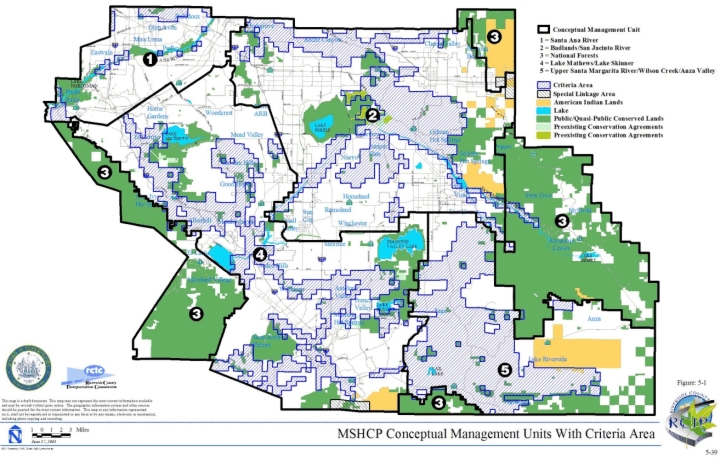
Santa Ana River Management Unit
➤ Description of Unit
➤ Existing Management Entities
| TABLE 5-3 EXISTING MANAGEMENT ENTITIES FOR MANAGEMENT UNIT 1 |
|
|---|---|
| LANDS | MANAGEMENT ENTITY |
| Santa Ana Regional Park | County of Riverside Parks & Open Space District U.S. Army Corps of Engineers |
| Prado Basin | U.S. Army Corps of Engineers |
| Orange County Water District Lands | Orange County Water District |
| Chino Hills State Park | California Department of Parks and Recreation |
Badlands/San Jacinto River Management Unit
➤ Description of Unit
➤ Existing Management Entities
| TABLE 5-4 EXISTING MANAGEMENT ENTITIES FOR MANAGEMENT UNIT 2 |
|
|---|---|
| LANDS | MANAGEMENT ENTITY |
| Box Springs Reserve | University of California Regents |
| Sycamore Canyon Wilderness Park | City of Riverside Park and Recreation Department |
| Lake Perris State Recreation Area | California Department of Parks and Recreation |
| San Jacinto Wildlife Area | California Department of Fish and Game California Department of Parks and Recreation |
| De Anza Cycle Park/Norton Younglove Reserve | County of Riverside Park & Open Space District |
National Forests Management Unit
➤ Description of Unit
➤ Existing Management Entities
| TABLE 5-5 EXISTING MANAGEMENT ENTITIES FOR MANAGEMENT UNIT 3 |
|
|---|---|
| LANDS | MANAGEMENT ENTITY |
| Cleveland National Forest | U.S. Forest Service |
| San Bernardino National Forest | U.S. Forest Service |
Lake Mathews/ Lake Skinner Management Unit
➤ Description of Unit
➤ Existing Management Entities
| TABLE 5-6 EXISTING MANAGEMENT ENTITIES FOR MANAGEMENT UNIT 4 |
|
|---|---|
| LANDS | MANAGEMENT ENTITY |
| Lake Mathews/Estelle Mountain Reserve | Metropolitan Water District of Southern California California Department of Fish and Game Riverside County Habitat Conservation Agency Bureau of Land Management |
| Southwestern Riverside County Multi-Species Reserve | Metropolitan Water District of Southern California Riverside County Habitat Conservation Agency Riverside County Parks and Open Space District Bureau of Land Management |
| Santa Margarita Ecological Preserve | California State University, San Diego The Nature Conservancy California Department of Fish and Game |
| Santa Rosa Plateau Nature Reserve | California Department of Parks and Recreation County of Riverside The Nature Conservancy |
| Motte Rimrock Preserve | University of California Regents |
| Harford Springs Reserve | County of Riverside Parks & Open Space District |
| Kabian Park | County of Riverside Parks & Open Space District Bureau of Land Management |
| Emerson Oaks Reserve | University of California Regents |
Upper Santa Margarita River/Wilson Creek/Anza Valley Management Unit
➤ Description of Unit
➤ Existing Management Entities
| TABLE 5-7 EXISTING MANAGEMENT ENTITIES FOR MANAGEMENT UNIT 5 |
|
|---|---|
| LANDS | ENTITY |
| Anza-Borrego Desert State Park | California Department of Parks and Recreation |
| Beauty Mountain Management Area | Bureau of Land Management |
5.3 BIOLOGICAL MONITORING PROGRAM
5.3.1 Introduction
5.3.2 Monitoring Goals and Objectives
5.3.3 Monitoring Program Implementation Sequence
Initial Inventory and Assessment Phase
Years 1-5
Long-Term Monitoring Phase
Years 6 +
Every 8th Year
5.3.4 Inventory, Monitoring, and Sampling Considerations
➤ Extent of MSHCP Conservation Area to Inventory and Monitor
| a) The entire MSHCP Plan Area | 1,260,000 acres |
| b) MSHCP Plan Area that is undisturbed/undeveloped | 881,000 acres |
| c) MSHCP Plan Area that is Public/Quasi-Public Land or is proposed to be incorporated into the MSHCP Conservation Area (d + e) | 500,000 acres |
| d) MSHCP Conservation Area that is currently Public/Quasi-Public Land | 347,000 acres |
| e) Additional Reserve Lands to be added to MSHCP Conservation Area | 153,000 acres |
➤ Development of Inventory and Monitoring Protocols
➤ Sampling Design Considerations
➤ Establishment of Long-term Monitoring Sampling Stations
5.3.5 Vegetation Community/Wildlife Habitat Inventory and Monitoring
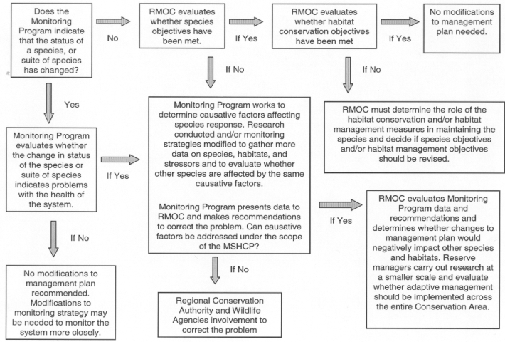
➤ Vegetation and Wildlife Community Inventory and Mapping
➤ Long-Term Vegetation Monitoring and Habitat Condition Assessment Monitoring
➤ Adaptive Strategy
5.3.6 Covered Species Inventory and Monitoring
➤ Baseline Inventory
➤ Development of Long-Term Covered Species Monitoring Strategies
➤ Long-Term Monitoring of Covered Species
| Latin Name | Common Name |
|---|---|
| Aimophila ruficeps canescens | So. Cal. rufous-crowned sparrow |
| Amphispiza belli belli | Bell's sage sparrow |
| Campylorhynchus brunneicapillus | cactus wren |
| Canis latrans | coyote |
| Chaetodipus fallax fallax | northwestern San Diego pocket mouse |
| Cnemidophorus hyperythrus beldingi | Belding's orange-throated whiptail |
| Cnemidophoris tigris multiscutatus | coastal western whiptail |
| Coleonyx variegatus abbottii | San Diego banded gecko |
| Crotalus ruber rubber | northern red-diamond rattlesnake |
| Dipodomys simulans | Dulzura kangaroo rat |
| Harpagonella palmeri | Palmer's grapplinghook |
| Lepus californicus bennettii | San Diego black-tailed jackrabbit |
| Mustela frenata | long-tailed weasel |
| Neotoma lepida intermedia | San Diego desert woodrat |
| Phacelia stellaris | Brand's phacelia |
| Polioptila californica californica | coastal California gnatcatcher |
| Phrynosoma coronatum blainvillei | San Diego horned lizard |
| Puma concolor | mountain lion |
| Romneya coulteri | Coulter's matilija poppy |
| Sceloporus orcutti | granite spiny lizard |
| Sylvilagus bachmani | brush rabbit |
| Sceloperus graciosus vandenburgianus | southern sagebrush lizard |
| Xantusia henshawi henshawi | granite night lizard |
| Latin Name | Common Name |
|---|---|
| Allium marvinii | Yucaipa onion |
| Ammodramus savannarum | grasshopper sparrow |
| Aquila chrysaetos | golden eagle |
| Buteo regalis | ferruginous hawk |
| Buteo swainsoni | Swainson's hawk |
| Cathartes aura | turkey vulture |
| Caulanthus simulans | Payson's jewelflower |
| Charadrius montanus | mountain plover |
| Chorizanthe polygonoides var. longispina | long-spined spine flower |
| Circus cyaneus | northern harrier |
| Dipodomys stephensi | Stephens' kangaroo rat |
| Elanus leucurus | white-tailed kite |
| Eremophila alpestris actia | California horned lark |
| Erodium macrophyllum | round-leaved filaree |
| Falco mexicanus | prairie falcon |
| Lanius ludovicianus | loggerhead shrike |
| Perognathus longimembris brevinasus | Los Angeles pocket mouse |
| Athene cunicularia hypugaea | burrowing owl |
| Latin Name | Common Name |
|---|---|
| Accipiter cooperii | Cooper's hawk |
| Accipiter striatus | sharp-shinned hawk |
| Catastamus santaanae | Santa Ana sucker |
| Clemmys marmarota pallida | western pond turtle |
| Coccyzus americanus occidentalis | western yellow-billed cuckoo |
| Dendroica petechia brewsteri | yellow warbler |
| Empidonax traillii extimus | southwestern willow flycatcher |
| Falco columbarius | merlin |
| Gila orcutti | arroyo chub |
| Icteria virens | yellow-breasted chat |
| Juglans californica var. californica | California black walnut |
| Lynx rufus | bobcat |
| Nama stenocarpum | mud nama |
| Picoides pubescens | downy woodpecker |
| Polygala cornuta var. fishiae | fish's milkwort |
| Tachycineta bicolor | tree swallow |
| Vireo bellii pusillus | least Bell's vireo |
| Wilsonia pusilla | Wilson's warbler |
| Latin Name | Common Name |
|---|---|
| Agelaius tricolor | tricolored blackbird |
| Ardea herodias | great blue heron |
| Botaurus lentiginosus | American bittern |
| Falco peregrinus | peregrine falcon |
| Haliaeetus leucocephalus | bald eagle |
| Nycticorax nycticorax | black-crowned night heron |
| Pandion haliaetus | osprey |
| Plegadis chihi | white-faced ibis |
| Phalacrocorax auritus | double-crested cormorant |
| Latin Name | Common Name |
|---|---|
| Atriplex coronata var. notatior | San Jacinto Valley crownscale |
| Atriplex parishii | Parish's brittlescale |
| Atriplex serenana var. davidsonii | Davidson's saltscale |
| Brachinecta lynchi | vernal pool fairy shrimp |
| Brodiaea filifolia | thread-leaved brodiaea |
| Centromadia (=Hemizonia) pungens ssp. laevis | smooth tarplant |
| Hordeum intercedens | vernal barley |
| Lasthenia glabrata ssp. coulteri | Coulter's goldfields |
| Muhlenbergia californica | California muhly |
| Myosurus minimus | little mousetail |
| Navarretia fossalis | spreading navarretia |
| Navarretia prostrate | prostrate navarretia |
| Orcuttia californica | California Orcutt grass |
| Scaphiopus hammondii | western spadefoot toad |
| Streptocephalus woottoni | Riverside fairy shrimp |
| Latin Name | Common Name |
|---|---|
| Accipiter gentiles | northern goshawk |
| Arabis johnstonii | Johnston's rock cress |
| Astragalus pachypus var. jaegeri | Jaeger's milk-vetch |
| Berberis nevinii | Nevin's barberry |
| Bufo californicus | arroyo toad |
| Calochortus palmeri var. munzii | Munz's Mariposa lily |
| Calochortus plummerae | Plummer's Mariposa lily |
| Calochortus weedii var. intermedius | intermediate Mariposa lily |
| Ceanothus ophiochilus | Vail Lake ceanothus |
| Charina bottae umbratica | southern rubber boa |
| Chorizanthe procumbens | prostrate spine flower |
| Convolvulus simulans | small-flowered morning-glory |
| Cypseloides niger | black swift |
| Deinandra (=Hemizonia) mohavensis | Mojave tarplant |
| Dudleya multicaulis | many-stemmed dudleya |
| Dudleya viscida | sticky-leaved dudleya |
| Galium angustifolium ssp. jacinticum | San Jacinto Mountains bedstraw |
| Galium californicum ssp. primum | California bedstraw |
| Glaucomys sabrinus californicus | San Bernardino flying squirrel |
| Heucheria hirsutissima | shaggy-haired alumroot |
| Holocarpha virgata ssp. elongate | graceful tarplant |
| Hulsea vestita ssp. callicarpha | beautiful hulsea |
| Lampropeltis zonata parvirubra | San Bernardino mountain kingsnake |
| Lampropeltis zonata pulchra | San Diego mountain kingsnake |
| Lepechinia cardiophylla | heart-leaved pitcher sage |
| Lilium humboldtii ssp. ocellatum | ocellated Humboldt lily |
| Lilium parryi | lemon lily |
| Melospiza lincolnii | Lincoln's sparrow |
| Mimulus clevelandii | Cleveland's bush monkeyflower |
| Mimulus diffusus | Palomar monkeyflower |
| Monardella macrantha ssp. hallii | Hall's monardella |
| Oporonis tolmiei | MacGillivray's warbler |
| Oreortyx pictus | mountain quail |
| Oxytheca caryophylloides | chickweed oxytheca |
| Penstemon californicus | California beardtongue |
| Potentilla rimicola | cliff cinquefoil |
| Progne subis | purple martin |
| Quercus engelmannii | Engelmann oak |
| Rana aurora draytonii | California red-legged frog |
| Rana mucosa | mountain yellow-legged frog |
| Satureja chandleri | San Miguel savory |
| Sibaropsis hammittii | Hammitt's clay-cress |
| Sphyrapicus thyroideus | Williamson's sapsucker |
| Strix occidentalis occidentalis | California spotted owl |
| Taricha tarosa tarosa | coast range newt |
| Vermivora ruficapilla | Nashville warbler |
| Latin Name | Common Name |
|---|---|
| Allium munzii | Munz's onion |
| Ambrosia pumila | San Diego ambrosia |
| Arctostaphylos rainbowensis | rainbow manzanita |
| Brodiaea orcuttii | Orcutt's brodiaea |
| Chorizanthe leptotheca | peninsular spine flower |
| Chorizanthe parryi var. parryi | Parry's spine flower |
| Dipodomys merriami collinus | Aguanga kangaroo rat |
| Dipodomys merriami parvus | San Bernardino kangaroo rat |
| Dodecahema leptoceras | slender-horned spine flower |
| Eriastrum densifolium ssp. sanctorum | Santa Ana River woollystar |
| Eryngium aristulatum var. parishii | San Diego button-celery |
| Euphydryas editha quino | Quino checkerspot butterfly |
| Limnanthes gracilis ssp. parishii | Parish's meadowfoam |
| Linderiella santarosae | Santa Rosa Plateau fairy shrimp |
| Microseris douglasii ssp. platycarpha | small-flowered microseris |
| Raphiomidas terminatus abdominalis | Delhi Sands flower-loving fly |
| Trichocoronis wrightii var. wrightii | Wright's trichocoronis |
➤ Monitoring of Covered Species as per Species Objectives
| TABLE 5-8 Summary of Survey Requirements for Covered Species as per the Species Objectives |
||||||||
|---|---|---|---|---|---|---|---|---|
| TAXA* | LATIN NAME | COMMON NAME | Baseline survey conducted within first 5 years | Monitor Distrib. at least every "X" years | Monitor Reproduction every "X" years | Monitor Abundance every "X" years | Demonstrate Conservation | Min. level occup. of known locations (%) |
| A | Bufo californicus | arroyo toad | x | 8 | 1 to 5 | 80 | ||
| A | Rana aurora draytonii | California red-legged frog | x | 8 | 1** | 75 | ||
| A | Rana mucosa | mountain yellow-legged frog | x | 8 | 1** | 75 | ||
| A | Scaphiopus hammondii | western spadefoot | x | 8 | 8 | 75 | ||
| A | Taricha tarosa tarosa | coast range newt | x | 8 | 1** | 75 | ||
| B | Accipiter cooperii | Cooper's hawk | x | 8 | 75 | |||
| B | Accipiter gentiles | northern goshawk | x | 3 | 3 | 75 | ||
| B | Accipiter striatus | sharp-shinned hawk | x | 8 | 75 | |||
| B | Agelaius tricolor | tricolored blackbird | x | 5 | 5 | 75 | ||
| B | Aimophila ruficeps canescens | Southern California rufous-crowned sparrow | x | 8 | 75 | |||
| B | Ammodramus savannarum | grasshopper sparrow | x | 1 to 5 | 1** | x | 75 | |
| B | Amphispiza belli belli | Bells' sage sparrow | x | 8 | 75 | |||
| B | Aquila chrysaetos | golden eagle | x | 8 | 8 | 75 | ||
| B | Ardea herodias | great blue heron | x | 8 | 75 | |||
| B | Athene cunicularia hypugaea | burrowing owl | x | 8 | 75 | |||
| B | Botaurus lentiginosus | American bittern | x | 8 | 50 | |||
| B | Buteo regalis | ferruginous hawk | x | 8 | 75 | |||
| B | Buteo swainsoni | Swainson's hawk | x | 8 | 75 | |||
| B | Campylorhynchus brunneicapillus | cactus wren | x | 8 | 75 | |||
| B | Cathartes aura | turkey vulture | x | 8 | 3 | 75 | ||
| B | Charadrius montanus | mountain plover | x | 8 | 75 | |||
| B | Circus cyaneus | northern harrier | x | 5 | 5 | 75 | ||
| B | Coccyzus americanus occidentalis | western yellow-billed cuckoo | x | 3 | 3 | 75 | ||
| B | Cypseloides niger | black swift | x | 8 | 75 | |||
| B | Dendroica petechia brewsteri | yellow warbler | x | 5 | 5 | 75 | ||
| B | Elanus leucurus | white-tailed kite | x | 8 | 3 | 75 | ||
| B | Empidonax traillii extimus | southwestern willow flycatcher | x | 3 | 3 | 75 | ||
| B | Eremophila alpestris actia | California horned lark | x | 8 | 75 | |||
| B | Falco columbarius | merlin | x | 8 | 75 | |||
| B | Falco mexicanus | prairie falcon | x | 8 | 75 | |||
| B | Falco peregrinus | peregrine falcon | x | 8 | 75 | |||
| B | Haliaeetus leucocephalus | bald Eagle | x | 8 | 75 | |||
| B | Icteria virens | yellow-breasted chat | x | 5 | 5 | 75 | ||
| B | Lanius ludovicianus | loggerhead shrike | x | 8 | 8 | 75 | ||
| B | Melospiza lincolnii | Lincoln sparrow | x | 8 | x | 75 | ||
| B | Nycticorax nycticorax | black-crowned night heron | x | 8 | 75 | |||
| B | Oporornis tolmiei | MacGillivray's warbler | x | 8 | 75 | |||
| B | Oreortyx pictus | mountain quail | x | 8 | 75 | |||
| B | Pandion haliaetus | osprey | x | 8 | 75 | |||
| B | Phalacrocorax auritus | double-crested cormorant | x | 8 | 75 | |||
| B | Picoides pubescens | downy woodpecker | x | 8 | 75 | |||
| B | Plegadis chihi | white-faced ibis | x | 8 | 75 | |||
| B | Polioptila californica californica | coastal California gnatcatcher | x | 3 | 3 | 75 | ||
| B | Progne subis | purple martin | x | 8 | 75 | |||
| B | Sphyrapicus thyroideus | Williamson's sapsucker | x | 8 | 75 | |||
| B | Strix occidentalis occidentalis | California spotted owl | x | 8 | 75 | |||
| B | Tachycineta bicolor | tree swallow | x | 8 | 75 | |||
| B | Vermivora ruficapilla | Nashville warbler | x | 8 | 75 | |||
| B | Vireo bellii pusillus | least Bell's vireo | x | 3 | 3 | 75 | ||
| B | Wilsonia pusilla | Wilson's warbler | x | 8 | 75 | |||
| F | Catastomus santaanae | Santa Ana sucker | x | 8 | 75 | |||
| F | Gila orcutti | arroyo chub | x | 8 | 75 | |||
| I | Branchinecta lynchi | vernal pool fairy shrimp | x | 8 | 75 | |||
| I | Euphydryas editha quino | Quino checkerspot | x | 1 | 75 | |||
| I | Linderiella santarosae | Santa Rosa Plateau fairy shrimp | x | 8 | 75 | |||
| I | Rhaphiomidas terminatus abdominalis | Delhi Sands flower-loving fly | x | 8 | 1** | 75 | ||
| I | Streptocephalus woottoni | Riverside fairy shrimp | x | 8 | 75 | |||
| M | Canis latrans | coyote | x | 8 | 75 | |||
| M | Chaetodipus fallax fallax | northwestern San Diego pocket mouse | x | 8 | 75 | |||
| M | Dipodomys merriami collinus | Aquanga kangaroo rat | x | 8 | 1 to 8 | 75 & 20 | ||
| M | Dipodomys merriami parvus | San Bernardino kangaroo rat | x | 8 | 1 to 8 | 75 | ||
| M | Dipodomys simulans | Dulzura kangaroo rat | x | 8 | 75 | |||
| M | Dipodomys stephensi | Stephens' kangaroo rat | x | 1 to 8 | 1 to 8 | 75 | ||
| M | Glaucomys sabrinus californicus | San Bernardino flying squirrel | x | 8 | x | 75 | ||
| M | Lepus californicus bennettii | San Diego black-tailed jackrabbit | x | 8 | 75 | |||
| M | Lynx rufus | bobcat | x | 8 | 75 | |||
| M | Mustela frenata | long-tailed weasel | x | 8 | 75 | |||
| M | Neotoma lepida intermedia | San Diego desert woodrat | x | 8 | 75 | |||
| M | Perognathus longimembris brevinasus | Los Angeles pocket mouse | x | 1 to 8 | 1 to 8 | 75 | ||
| M | Puma concolor | mountain lion | x | 8 | 75 | |||
| M | Sylvilagus bachmani | brush rabbit | x | 8 | 75 | |||
| P | Allium marvinii | Yucaipa onion | x | 8 | 75 | |||
| P | Allium munzii | Munz's onion | x | 8 | 75 | |||
| P | Ambrosia pumila | San Diego ambrosia | x | 8 | 75 | |||
| P | Arabis johnstonii | Johnston's rock cress | x | 8 | 75 | |||
| P | Arctostaphylos rainbowensis | Rainbow manzanita | x | 8 | x | 75 | ||
| P | Astragalus pachypus var. jaegeri | Jaeger's milk-vetch | x | 8 | 75 | |||
| P | Atriplex coronata var. notatior | San Jacinto Valley crownscale | x | 8 | 75 | |||
| P | Atriplex parishii | Parish's brittlescale | x | 8 | 75 | |||
| P | Atriplex serenana var. davidsonii | Davidson's saltscale | x | 8 | 75 | |||
| P | Berberis nevinii | Nevin's barberry | x | 8 | 75 | |||
| P | Brodiaea filifolia | thread-leaved brodiaea | x | 8 | 75 | |||
| P | Brodiaea orcuttii | Orcutt's brodiaea | x | 8 | 75 | |||
| P | Calochortus palmeri var. munzii | Munz's mariposa lily | x | 8 | 75 | |||
| P | Calochortus plummerae | Plummer's mariposa lily | x | 8 | x | 75 | ||
| P | Calochortus weedii var. intermedius | intermediate mariposa lily | x | 8 | 75 | |||
| P | Caulanthus simulans | Payson's jewelflower | x | 8 | 75 | |||
| P | Ceanothus ophiochilus | Vail Lake ceanothus | x | 8 | 75 | |||
| P | Centromadia pungens ssp. laevis | smooth tarplant | x | 8 | 75 | |||
| P | Chorizanthe leptotheca | peninsular spine flower | x | 8 | x | 75 | ||
| P | Chorizanthe parryi var. parryi | Parry's spine flower | x | 8 | x | 75 | ||
| P | Chorizanthe polygonoides var. longispina | long-spined spine flower | x | 8 | 75 | |||
| P | Chorizanthe procumbens | prostrate spine flower | x | 8 | 75 | |||
| P | Convolvulus simulans | small-flowered morning-glory | x | 8 | 75 | |||
| P | Deinandra mohavensis | Mojave tarplant | x | 8 | x | 75 | ||
| P | Dodecahema leptoceras | slender-horned spine flower | x | 8 | 75 | |||
| P | Dudleya multicaulis | many-stemmed dudleya | x | 8 | 75 | |||
| P | Dudleya viscida | sticky-leaved dudleya | x | 8 | 75 | |||
| P | Eriastrum densifolium ssp. sanctorum | Santa Ana River woollystar | x | 8 | 75 | |||
| P | Erodium macrophyllum | round-leaved filaree | x | 8 | 75 | |||
| P | Eryngium aristulatum var. parishii | San Diego button-celery | x | 8 | 75 | |||
| P | Galium angustifolium ssp. jacinticum | San Jacinto Mountains bedstraw | x | 8 | 75 | |||
| P | Galium californicum ssp. primum | California bedstraw | x | 8 | 75 | |||
| P | Harpagonella palmeri | Palmer's grapplinghook | x | 8 | 75 | |||
| P | Heuchera hirsutissima | shaggy-haired alumroot | x | 8 | 75 | |||
| P | Holocarpha virgata ssp. elongata | graceful tarplant | x | 8 | x | 75 | ||
| P | Hordeum intercedens | vernal barley | x | 8 | 75 | |||
| P | Hulsea vestita ssp. callicarpha | beautiful hulsea | x | 8 | x | 75 | ||
| P | Juglans californica var. californica | California black walnut | x | 8 | 75 | |||
| P | Lasthenia glabrata ssp. coulteri | Coulter's goldfields | x | 8 | 75 | |||
| P | Lepechinia cardiophylla | heart-leaved pitcher sage | x | 8 | 75 | |||
| P | Lilium humboldtii ssp. ocellatum | ocellated Humboldt lily | x | 8 | 75 | |||
| P | Lilium parryi | lemon lily | x | 8 | 75 | |||
| P | Limnanthes gracilis var. parishii | Parish's meadowfoam | x | 8 | 75 | |||
| P | Microseris douglasii var. platycarpha | small-flowered microseris | x | 8 | x | 75 | ||
| P | Mimulus clevelandii | Cleveland's bush monkeyflower | x | 8 | 75 | |||
| P | Mimulus diffusus | Palomar monkeyflower | x | 8 | 75 | |||
| P | Monardella macrantha ssp. hallii | Hall's monardella | x | 8 | 75 | |||
| P | Muhlenbergia californica | California muhly | x | 8 | x | 75 | ||
| P | Myosurus minimus | little mousetail | x | 8 | 75 | |||
| P | Nama stenocarpum | mud nama | x | 8 | 75 | |||
| P | Navarretia fossalis | spreading navarretia | x | 8 | 75 | |||
| P | Navarretia prostrata | prostarte navarretia | x | 8 | 75 | |||
| P | Orcuttia californica | California Orcutt grass | x | 8 | 75 | |||
| P | Oxytheca caryophylloides | chickweed oxytheca | x | 8 | x | 75 | ||
| P | Penstemon californicus | California beardtongue | x | 8 | 75 | |||
| P | Phacelia stellaris | Brand's phacelia | x | 8 | 75 | |||
| P | Polygala cornuta var. fishiae | Fish's milkwort | x | 8 | x | 75 | ||
| P | Potentilla rimicola | cliff cinquefoil | x | 8 | x | 75 | ||
| P | Quercus engelmannii | Engelmann oak | x | 8 | 1 to 5 | 80 | ||
| P | Romneya coulteri | Coulter's matilija poppy | x | 8 | x | 75 | ||
| P | Satureja chandleri | San Miguel savory | x | 8 | 75 | |||
| P | Sibaropsis hammittii | Hammitt's clay-cress | x | 8 | 75 | |||
| P | Trichocoronis wrightii var. wrightii | Wright's trichocoronis | x | 8 | 75 | |||
| R | Charina bottae umbratica | southern rubber boa | x | 8 | 75 | |||
| R | Clemmys marmorata pallida | western pond turtle | x | 3 | 75 | |||
| R | Cnemidophorus hyperythrus beldingi | Belding's orange-throated whiptail | x | 8 | 75 | |||
| R | Cnemidophorus tigris multiscutatus | coastal western whiptail | x | 8 | 75 | |||
| R | Coleonyx variegatus abbottii | San Diego banded gecko | x | 8 | 75 | |||
| R | Crotalus ruber ruber | northern red-diamond rattlesnake | x | 8 | 75 | |||
| R | Lampropeltis zonata parvirubra | San Bernardino mountain kingsnake | x | 8 | 75 | |||
| R | Lampropeltis zonata pulchra | San Diego mountain kingsnake | x | 8 | 75 | |||
| R | Phrynosoma coronatum blainvillei | San Diego horned lizard | x | 8 | 75 | |||
| R | Sceloporus graciosus vandenburgianus | southern sagebrush lizard | x | 8 | 75 | |||
| R | Sceloporus orcutti | granite spiny lizard | x | 8 | 75 | |||
| R | Xantusia henshawi henshawi | granite night lizard | x | 8 | 75 | |||
➤ Evaluating Linkages and Roadway Crossings (e.g., culverts, underpasses)
➤ Species Used to Provide Information about Condition or Health of Vegetation Communities/Wildlife Habitats
➤ Adaptive Strategy
5.3.7 Responsibilities, Coordination, and Reporting
5.3.8 Data Management
➤ Monitoring Program Database
➤ Archival Roles and Responsibilities
➤ Data Handling Practices
➤ Data Availability
➤ Data Compilation and Analysis
5.3.9 Anticipated Levels of Effort and Estimated Costs
| TABLE 5-9 ESTIMATED TOTAL PERSONNEL - YEARS BY LEVEL OF EFFORT AND POSITION LEVEL |
||||||||||
|---|---|---|---|---|---|---|---|---|---|---|
| Inventory and Assessment Phase | Long-Term Monitoring Phase | |||||||||
| Estimated Personnel (PY's) | Year 1 | Year 2 | Year 3 | Year 4 | Year 5 | Year 6 | Year 7 | Year 8 | Year 9 | Year 10 |
| ADMINISTRATION | ||||||||||
| Program Administrator/Senior Field Supervisor | 2 | 2 | 2 | 2 | 2 | 2 | 2 | 2 | 2 | 2 |
| DATA RETRIEVAL, STORAGE, & MANAGEMENT | ||||||||||
| Research Analyst II | 0.5 | 0.5 | 0.5 | 0.5 | 0.5 | 0.5 | 0.5 | 0.5 | 0.5 | 0.5 |
| GIS SUPPORT | ||||||||||
| Research Analyst II | 1 | 1 | 1 | 1 | 1 | 1 | 1 | 1 | 1 | 1 |
| Research Analyst I | 0 | 0 | 0 | 0 | 0 | 0 | 1 | 1 | 1 | 1 |
| VEGETATION & WILDLIFE RAPID ASSESSMENT PROTOCOL SURVEYS | ||||||||||
| Associate Botanist | † | 0 | 0 | 0 | 0 | 0 | † | † | 0 | 0 |
| Biologist | 1.5 | 0 | 0 | 0 | 0 | 0 | 0 | 1.5 | 0 | 0 |
| Seasonal Aid | 1.5 | 0 | 0 | 0 | 0 | 0 | 0 | 1.5 | 0 | 0 |
| COVERED SPECIES SURVEYS | ||||||||||
| Associate Biologist | 5 | 5 | 5 | 5 | 5 | 5 | 5 | 5 | 5 | 5 |
| Biologist | 6.5 | 6.5 | 6.5 | 6.5 | 6.5 | 11 | 11 | 11 | 11 | 11 |
| Seasonal Aid | 6 | 6 | 6 | 6 | 6 | 9 | 9 | 9 | 9 | 9 |
| Estimated Total PYs | 24 | 21 | 21 | 21 | 21 | 28.5 | 29.5 | 32.5 | 29.5 | 29.5 |
| † Associate Botanist position is included in the Associate Biologist positions listed under the Covered Species Surveys level of effort. | ||||||||||
| TABLE 5-10 ESTIMATED TOTAL COST (IN 2002 DOLLARS) FOR PERSONNEL AND EQUIPMENT/ SUPPLIES BY LEVEL OF EFFORT AND POSITION LEVEL |
|||||||||||
|---|---|---|---|---|---|---|---|---|---|---|---|
| Inventory and Assessment Phase | Long-Term Monitoring Phase | ||||||||||
| Estimated Personnel (PYs) | Salary* | Year 1 | Year 2 | Year 3 | Year 4 | Year 5 | Year 6 | Year 7 | Year 8 | Year 9 | Year 10 |
| ADMINISTRATION | |||||||||||
| Program Administrator/Sr. Field Supervisor | 100,000 | 200,000 | 200,000 | 200,000 | 200,000 | 200,000 | 200,000 | 200,000 | 200,000 | 200,000 | 200,000 |
| DATA RETRIEVAL, STORAGE, & MGMT | |||||||||||
| Research Analyst II | 80,000 | 40,000 | 40,000 | 40,000 | 40,000 | 40,000 | 40,000 | 40,000 | 40,000 | 40,000 | 40,000 |
| GIS SUPPORT | |||||||||||
| Research Analyst II | 80,000 | 80,000 | 80,000 | 80,000 | 80,000 | 80,000 | 80,000 | 80,000 | 80,000 | 80,000 | 80,000 |
| Research Analyst I | 70,000 | 0 | 0 | 0 | 0 | 0 | 0 | 70,000 | 70,000 | 70,000 | 70,000 |
| VEG. & WILDLIFE RAPID ASSESSMENT SURVEYS | |||||||||||
| Associate Botanist | 80,000 | † | 0 | 0 | 0 | 0 | 0 | † | † | 0 | 0 |
| Biologist | 70,000 | 105,000 | 0 | 0 | 0 | 0 | 0 | 0 | 105,000 | 0 | 0 |
| Seasonal Aid | 30,000 | 45,000 | 0 | 0 | 0 | 0 | 0 | 0 | 45,000 | 0 | 0 |
| COVERED SPECIES SURVEYS | |||||||||||
| Associate Biologist | 80,000 | 400,000 | 400,000 | 400,000 | 400,000 | 400,000 | 400,000 | 400,000 | 400,000 | 400,000 | 400,000 |
| Biologist | 70,000 | 455,000 | 455,000 | 455,000 | 455,000 | 455,000 | 770,000 | 770,000 | 770,000 | 770,000 | 770,000 |
| Seasonal Aid | 30,000 | 180,000 | 180,000 | 180,000 | 180,000 | 180,000 | 270,000 | 270,000 | 270,000 | 270,000 | 270,000 |
| Subtotal Personnel | 1,505,000 | 1,355,000 | 1,355,000 | 1,355,000 | 1,355,000 | 1,760,000 | 1,830,000 | 1,980,000 | 1,830,000 | 1,830,000 | |
| EQUIPMENT & SUPPLIES | |||||||||||
| Aerial/Satellite Imagery | 50,000 | 100,000 | |||||||||
| Sampling Gear | 30,000 | 30,000 | 30,000 | 30,000 | 30,000 | 30,000 | 30,000 | 30,000 | 30,000 | 30,000 | |
| Transect Set-up & Maintenance | 5,000 | 5,000 | 5,000 | 5,000 | 5,000 | 1,000 | 1,000 | 1,000 | 1,000 | 1,000 | |
| Radio-tracking Equipment | 5,000 | 2,000 | 2,000 | 2,000 | 2,000 | 20,000 | |||||
| Other Supplies | 10,000 | 10,000 | 10,000 | 10,000 | 10,000 | 10,000 | 10,000 | 10,000 | 10,000 | 10,000 | |
| Subtotal Equipment and Supplies | 100,000 | 45,000 | 47,000 | 45,000 | 47,000 | 41,000 | 143,000 | 41,000 | 43,000 | 61,000 | |
| Estimated SubTotal | 1,605,000 | 1,400,000 | 1,402,000 | 1,400,000 | 1,402,000 | 1,801,000 | 1,973,000 | 2,021,000 | 1,873,000 | 1,891,000 | |
| 10% Contingency | 160,500 | 140,000 | 140,200 | 140,000 | 140,200 | 180,100 | 197,300 | 202,100 | 187,300 | 189,100 | |
| Estimated Total Cost** | 1,765,500 | 1,540,000 | 1,542,200 | 1,540,000 | 1,542,200 | 1,981,100 | 2,170,300 | 2,223,100 | 2,060,300 | 2,080,100 | |
| * Salary includes benefits, worker's compensation, travel, office supplies, etc. ** Estimate does not include cost of office space or vehicles; it is assumed that the County and Wildlife Agencies will provide office space and vehicles as needed. † Associate Botanist position is included in the Covered Species Surveys level of effort. |
|||||||||||