

SECTION 3.0
CONSERVATION PLANNING PROCESS/DESCRIPTION AND
AREA PLAN CRITERIA OF THE MSHCP CONSERVATION AREA
3.1 CONSERVATION PLANNING PROCESS
3.1.1 Process Background
3.1.2 Overall MSHCP Goals and Conservation Planning
3.1.3 Compilation of Existing Data
3.1.4 Applicable Conservation Biology Principles
3.1.5 Review of Reserve Selection Models and Methods
3.1.6 Conceptual Conservation Scenario
3.1.7 Informal Gap Analysis
➤ Methods
➤ Results
Northwest Section of Plan Area
Northeast Section of Plan Area
Southwest Section of Plan Area
Southeast Section of Plan Area
3.1.8 Identification of Alternatives and Selection of Proposed Alternative
3.1.9 Conceptual Reserve Design/Criteria-Based Plan
3.1.10 Description and Analysis of MSHCP Conservation Area
3.2 DESCRIPTION OF THE MSHCP CONSERVATION AREA
3.2.1 The MSHCP Plan Map
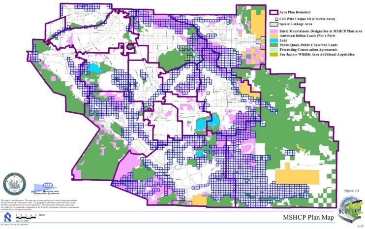
3.2.2 The MSHCP Conservation Area
➤ Bioregions
➤ Vegetation
| TABLE 3-1 ESTIMATE OF CONSERVATION BY VEGETATION COMMUNITY |
|||||||||||||||||||
|---|---|---|---|---|---|---|---|---|---|---|---|---|---|---|---|---|---|---|---|
| Vegetation | Total Acres in Plan Area1 | Total Acres in Existing Public/ Quasi-Public Lands | Total Acres of Additional Reserve Lands | Total Acres Conserved | Percent of Total Vegetation Community Acres Conserved in Plan Area | ||||||||||||||
| Agriculture | 169,480 | 11,480 | 8,540 | 20,020 | 12% | ||||||||||||||
| Chaparral | 434,950 | 207,380 | 64,900 | 272,280 | 63% | ||||||||||||||
| Cismontane Alkali Marsh | 1,260 | <5 | 40 | 40 | 3% | ||||||||||||||
| Coastal Sage Scrub | 156,450 | 34,560 | 47,160 | 81,720 | 52% | ||||||||||||||
| Desert Scrubs | 14,570 | 1,310 | 3,680 | 4,990 | 34% | ||||||||||||||
| Grassland | 154,140 | 22,810 | 20,010 | 42,820 | 28% | ||||||||||||||
| Meadows and Marshes | 1,020 | 330 | 180 | 510 | 50% | ||||||||||||||
| Montane Coniferous Forest | 29,910 | 20,480 | 20 | 20,500 | 69% | ||||||||||||||
| Playas and Vernal Pools | 7,910 | 2,920 | 3,830 | 6,750 | 85% | ||||||||||||||
| Riparian Scrub, Woodland, Forest | 15,030 | 7,270 | 3,920 | 11,190 | 74% | ||||||||||||||
| Riversidean Alluvial Fan Sage Scrub | 7,940 | 2,060 | 3,170 | 5,230 | 66% | ||||||||||||||
| Unknown | 1,350 | 1,230 | 10 | 1,240 | 92% | ||||||||||||||
| Water | 12,210 | 9,150 | 1,190 | 10,340 | 85% | ||||||||||||||
| Woodlands and Forests | 34,300 | 20,770 | 2,730 | 23,500 | 69% | ||||||||||||||
| Developed or Disturbed Land | 218,260 | 4,780 | - | 4,780 | 2% | ||||||||||||||
| TOTALS | 1,258,780 | 346,530 | 159,3802 | 505,910 | |||||||||||||||
1 This includes the following acreages of each Vegetation Community on American Indian Lands that, while within the Plan Area, are not a part of the Plan:
Total is not exact due to rounding. |
|||||||||||||||||||
➤ Soils
➤ Patch Size
➤ Edge Affected Land After Completion of Reserve Assembly
3.2.3 Cores and Linkages within the MSHCP Conservation Area
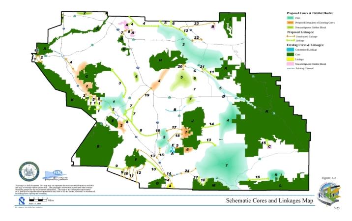
Index for Cores and Linkages
Existing Core A
| EXISTING CORE A | |||||||
|---|---|---|---|---|---|---|---|
| Approximate Dimension Data for Core | Planning Species | Adjacent Proposed General Plan Land Use |
Major Covered Activities Potentially Affecting Core | ||||
| Approx. Total (ac.) |
Approx. Edge (ac.) |
Approx. Interior (ac.) |
Approx. Perimeter/ Area Ratio (ft/ac) |
Approx. Distance to Nearest Connected Core (miles) |
|||
| 10,740 | 1,640 | 9,100 | 33 | 1.7 | Santa Ana sucker, arroyo chub, western pond turtle, Cooper's hawk, tricolored blackbird, burrowing owl, American bittern, cactus wren, northern harrier, western yellow-billed cuckoo, yellow warbler, white-tailed kite, southwestern willow flycatcher, California horned lark, peregrine falcon, yellow-breasted chat, loggerhead shrike, black-crowned night heron, osprey, double-crested cormorant, downy woodpecker, white-faced ibis, tree swallow, least Bell's vireo, bobcat, mountain lion, and Santa Ana River woollystar. | City (Corona, Norco, Riverside), Community Development, Open Space/Conservation | SR-71, River Road, Hammer, I-15, Schleisman, Van Buren, Mission, Market |
Existing Core B
| EXISTING CORE B | |||||||
|---|---|---|---|---|---|---|---|
| Approximate Dimension Data for Core | Planning Species | Adjacent Proposed General Plan Land Use |
Major Covered Activities Potentially Affecting Core | ||||
| Approx. Total (ac.) |
Approx. Edge (ac.) |
Approx. Interior (ac.) |
Approx. Perimeter/ Area Ratio (ft/ac) |
Approx. Distance to Nearest Connected Core (miles) |
|||
| 71,490 | 1,720 | 69,770 | 7 | 1.6 | Cooper's hawk, southern California rufous-crowned sparrow, Bell's sage sparrow, golden eagle, turkey vulture, yellow warbler, mountain quail, downy woodpecker, purple martin, California spotted owl, tree swallow, mountain lion, Palmer's grapplinghook, prostrate spine flower, graceful tarplant, and small-flowered microseris. | Rural Mountainous, Rural, Community Development, City (Lake Elsinore, Corona) | SR-74 |
Existing Core C
| EXISTING CORE C | |||||||
|---|---|---|---|---|---|---|---|
| Approximate Dimension Data for Core | Planning Species | Adjacent Proposed General Plan Land Use |
Major Covered Activities Potentially Affecting Core | ||||
| Approx. Total (ac.) |
Approx. Edge (ac.) |
Approx. Interior (ac.) |
Approx. Perimeter/ Area Ratio (ft/ac) |
Approx. Distance to Nearest Connected Core (miles) |
|||
| 15,610 | 890 | 14,720 | 19 | 1.6 | southern California rufous-crowned sparrow, Bell's sage sparrow, burrowing owl, cactus wren, northern harrier, white-tailed kite, loggerhead shrike, coastal California gnatcatcher, Stephens' kangaroo rat, bobcat, mountain lion, Munz's onion, slender-horned spine flower, and many-stemmed dudleya. | Rural, Rural Mountainous, Community Development | Hemet to Corona/Lake Elsinore, CETAP Corridor |
Existing Core D
| EXISTING CORE D | |||||||
|---|---|---|---|---|---|---|---|
| Approximate Dimension Data for Core | Planning Species | Adjacent Proposed General Plan Land Use |
Major Covered Activities Potentially Affecting Core | ||||
| Approx. Total (ac.) |
Approx. Edge (ac.) |
Approx. Interior (ac.) |
Approx. Perimeter/ Area Ratio (ft/ac) |
Approx. Distance to Nearest Connected Core (miles) |
|||
| 2,500 | 560 | 1,940 | 43 | 10.8 | Wilson's warbler | City (Riverside), Community Development | Alessandro Blvd. |
Existing Core E
| EXISTING CORE E | |||||||
|---|---|---|---|---|---|---|---|
| Approximate Dimension Data for Core | Planning Species | Adjacent Proposed General Plan Land Use |
Major Covered Activities Potentially Affecting Core | ||||
| Approx. Total (ac.) |
Approx. Edge (ac.) |
Approx. Interior (ac.) |
Approx. Perimeter/ Area Ratio (ft/ac) |
Approx. Distance to Nearest Connected Core (miles) |
|||
| 3,010 | 280 | 2,730 | 20 | 4.4 | Cooper's hawk, tricolored blackbird, southern California rufous-crowned sparrow, burrowing owl, American bittern, ferruginous hawk, Swainson's hawk, mountain plover, northern harrier, yellow warbler, white-tailed kite, California horned lark, peregrine falcon, bald eagle, yellow-breasted chat, loggerhead shrike, black-crowned night heron, mountain quail, osprey, double-crested cormorant, white-faced ibis, purple martin, tree swallow, least Bell's vireo, San Jacinto Valley crownscale, prostrate spine flower, Palmer's grapplinghook, and Engelmann oak. | City (Elsinore), Open Space, Conservation | None |
Existing Core F
| EXISTING CORE F | |||||||
|---|---|---|---|---|---|---|---|
| Approximate Dimension Data for Core | Planning Species | Adjacent Proposed General Plan Land Use |
Major Covered Activities Potentially Affecting Core | ||||
| Approx. Total (ac.) |
Approx. Edge (ac.) |
Approx. Interior (ac.) |
Approx. Perimeter/ Area Ratio (ft/ac) |
Approx. Distance to Nearest Connected Core (miles) |
|||
| 8,360 | 460 | 7,900 | 14 | 4.2 | vernal pool fairy shrimp, Santa Rosa Plateau fairy shrimp, Riverside fairy shrimp, California red-legged frog, western pond turtle, Cooper's hawk, sharp-shinned hawk, grasshopper sparrow, burrowing owl, cactus wren, turkey vulture, northern harrier, yellow warbler, southwestern willow flycatcher, California horned lark, merlin, loggerhead shrike, Lincoln's sparrow, MacGillivray's warbler, mountain quail, California spotted owl, Nashville warbler, Wilson's warbler, San Diego pocket mouse, bobcat, mountain lion, Rainbow manzanita, thread-leaved brodiaea, Orcutt's brodiaea, long-spined spine flower, San Diego button celery, graceful tarplant, vernal barley, California black walnut, Parish's meadowfoam, Palomar monkeyflower, little mousetail, spreading navarretia, California Orcutt grass, Fish's milkwort, Engelmann oak, and San Miguel savory. | Rural Mountainous, City (Murrieta) | Clinton Keith Road |
Existing Core G
| EXISTING CORE G | |||||||
|---|---|---|---|---|---|---|---|
| Approximate Dimension Data for Core | Planning Species | Adjacent Proposed General Plan Land Use |
Major Covered Activities Potentially Affecting Core | ||||
| Approx. Total (ac.) |
Approx. Edge (ac.) |
Approx. Interior (ac.) |
Approx. Perimeter/ Area Ratio (ft/ac) |
Approx. Distance to Nearest Connected Core (miles) |
|||
| 4,500 | 340 | 4,160 | 17 | 5.5 | arroyo chub, southern California rufous-crowned sparrow, Bell's sage sparrow, bobcat, mountain lion, and Rainbow manzanita. | Rural Mountainous | I-15 widen existing facility |
Existing Core H
| EXISTING CORE H | |||||||
|---|---|---|---|---|---|---|---|
| Approximate Dimension Data for Core | Planning Species | Adjacent Proposed General Plan Land Use |
Major Covered Activities Potentially Affecting Core | ||||
| Approx. Total (ac.) |
Approx. Edge (ac.) |
Approx. Interior (ac.) |
Approx. Perimeter/ Area Ratio (ft/ac) |
Approx. Distance to Nearest Connected Core (miles) |
|||
| 17,470 | 1,070 | 16,400 | 12 | 0 | western spadefoot, western pond turtle, coastal western whiptail, Belding's orange-throated whiptail, San Diego banded gecko, northern red diamond rattlesnake, San Diego horned lizard, granite spiny lizard, granite night lizard, burrowing owl, Cooper's hawk, sharp-shinned hawk, Southern California rufous-crowned sparrow, grasshopper sparrow, Bell's sage sparrow, golden eagle, American bittern, ferruginous hawk, Swainson's hawk, cactus wren, turkey vulture, yellow warbler, white-tailed kite, southwestern willow-flycatcher, peregrine falcon, bald eagle, yellow-breasted chat, loggerhead shrike, Lincoln's sparrow, black-crowned night heron, MacGillivray's warbler, osprey, double-crested cormorant, downy woodpecker, purple martin, tree swallow, northwestern San Diego pocket mouse, Stephens' kangaroo rat, San Diego black-tailed jackrabbit, bobcat, San Diego desert woodrat, Los Angeles pocket mouse, San Jacinto Valley crownscale, Davidson's saltscale, thread-leaved brodiaea, smooth tarplant, Coulter's goldfields, spreading navarretia, and Wright's trichocoronis. | Agriculture, Community Development, Cities (Moreno Valley and Perris) | Gilman Springs Road, Ramona Express-way, Bridge Street, CETAP Hemet to Corona/Lake Elsinore Alternative 1b. |
Existing Core I
| EXISTING CORE I | |||||||
|---|---|---|---|---|---|---|---|
| Approximate Dimension Data for Core | Planning Species | Adjacent Proposed General Plan Land Use |
Major Covered Activities Potentially Affecting Core | ||||
| Approx. Total (ac.) |
Approx. Edge (ac.) |
Approx. Interior (ac.) |
Approx. Perimeter/ Area Ratio (ft/ac) |
Approx. Distance to Nearest Connected Core (miles) |
|||
| 9,610 | 920 | 8,690 | 22 | 0.7* | San Bernardino mountain kingsnake, San Diego mountain kingsnake, Lincoln's sparrow, MacGillivray's warbler, mountain quail, Williamson's sapsucker, California spotted owl, Nashville warbler, Wilson's warbler, mountain lion, Plummer's mariposa lily, peninsular spine flower, and Hall's monardella. |
Indian Lands, Community Development,City (Banning) | None |
Existing Core J
| EXISTING CORE J | |||||||
|---|---|---|---|---|---|---|---|
| Approximate Dimension Data for Core | Planning Species | Adjacent Proposed General Plan Land Use |
Major Covered Activities Potentially Affecting Core | ||||
| Approx. Total (ac.) |
Approx. Edge (ac.) |
Approx. Interior (ac.) |
Approx. Perimeter/ Area Ratio (ft/ac) |
Approx. Distance to Nearest Connected Core (miles) |
|||
| 24,360 | 900 | 23,460 | 12 | 1.11 | Quino checkerspot butterfly, southern California rufous-crowned sparrow, grasshopper sparrow, Bell's sage sparrow, golden eagle, burrowing owl, cactus wren, turkey vulture, mountain plover, northern harrier, white-tailed kite, coastal California gnatcatcher, tree swallow, least Bell's vireo, bobcat, Los Angeles pocket mouse, mountain lion and long-spined spine flower. | Community Development, Rural, Rural Mountainous | Rawson Road, Borel Road, and Butterfield Stage Road |
Existing Core K
| EXISTING CORE K | |||||||
|---|---|---|---|---|---|---|---|
| Approximate Dimension Data for Core | Planning Species | Adjacent Proposed General Plan Land Use |
Major Covered Activities Potentially Affecting Core | ||||
| Approx. Total (ac.) |
Approx. Edge (ac.) |
Approx. Interior (ac.) |
Approx. Perimeter/ Area Ratio (ft/ac) |
Approx. Distance to Nearest Connected Core (miles) |
|||
| 149,750 | 3,160 | 146,590 | 6 | 0* | western pond turtle, northern red diamond rattlesnake, San Bernardino Mountain kingsnake, San Diego Mountain kingsnake, Cooper's hawk, northern goshawk, golden eagle, turkey vulture, black swift, yellow warbler, Lincoln's sparrow, Macgillvray's warbler, mountain quail, downy woodpecker, purple martin, Williamson's sapsucker, California spotted owl, tree swallow, Nashville warbler, Wilson's warbler, San Bernardino kangaroo rat, Stephens' kangaroo rat, mountain lion, Johnston's rock cress, Munz's mariposa lily, Plummer's mariposa lily, peninsular spine flower, slender-horned spine flower, San Jacinto Mountains bedstraw, California bedstraw, Mojave tarplant, graceful tarplant, Hall's monardella, California beardtongue | Rural and Rural Mountainous | SR-243, SR-74, SR-371, and Bautista Canyon Road |
Existing Core L
| EXISTING CORE L | |||||||
|---|---|---|---|---|---|---|---|
| Approximate Dimension Data for Core | Planning Species | Adjacent Proposed General Plan Land Use |
Major Covered Activities Potentially Affecting Core | ||||
| Approx. Total (ac.) |
Approx. Edge (ac.) |
Approx. Interior (ac.) |
Approx. Perimeter/ Area Ratio (ft/ac) |
Approx. Distance to Nearest Connected Core (miles) |
|||
| 24,750 | 590 | 24,160 | 12 | 0* | Quino checkerspot, Bell's sage sparrow, golden eagle nest site, cactus wren, coastal California gnatcatcher, least Bell's vireo, Aguanga kangaroo rat, Stephens' kangaroo rat, bobcat, Los Angeles pocket mouse, and mountain lion, . | Rural, Agriculture and Indian Lands | None |
Existing Core M
| EXISTING CORE M | |||||||
|---|---|---|---|---|---|---|---|
| Approximate Dimension Data for Core | Planning Species | Adjacent Proposed General Plan Land Use |
Major Covered Activities Potentially Affecting Core | ||||
| Approx. Total (ac.) |
Approx. Edge (ac.) |
Approx. Interior (ac.) |
Approx. Perimeter/ Area Ratio (ft/ac) |
Approx. Distance to Nearest Connected Core (miles) |
|||
| 10,460 | 180 | 10,280 | 14 | 3 | western pond turtle, granite night lizard, mountain lion, Jaeger's milk vetch, Nevin's barberry, Vail Lake ceanothus, long-spined spine flower, prostrate spine flower, beautiful hulsea, ocellated Humboldt lily, Palomar monkeyflower, and Hall's monardella. | Indian Lands, Open Space/ Conservation, Rural, Rural Mountainous | SR-79 |
Proposed Extension of Existing Core 1
| PROPOSED EXTENSION OF EXISTING CORE 1 | |||||||
|---|---|---|---|---|---|---|---|
| Approximate Dimension Data for Core | Planning Species | Adjacent Proposed General Plan Land Use |
Major Covered Activities Potentially Affecting Core | ||||
| Approx. Total (ac.) |
Approx. Edge (ac.) |
Approx. Interior (ac.) |
Approx. Perimeter/ Area Ratio (ft/ac) |
Approx. Distance to Nearest Connected Core (miles) |
|||
| 270 | 0* | 270 | 80 | N/A | Santa Ana sucker, arroyo chub, western pond turtle, Cooper's hawk, tricolored blackbird, American bittern, cactus wren, northern harrier, western yellow-billed cuckoo, yellow warbler, white-tailed kite, southwestern willow flycatcher, California horned lark, peregrine falcon, yellow-breasted chat, black-crowned night heron, double-crested cormorant, downy woodpecker, white-faced ibis, tree swallow, least Bell's vireo, and bobcat. | Open Space/ Conservation | None |
Proposed Extension of Existing Core 2
| PROPOSED EXTENSION OF EXISTING CORE 2 | |||||||
|---|---|---|---|---|---|---|---|
| Approximate Dimension Data for Core | Planning Species | Adjacent Proposed General Plan Land Use |
Major Covered Activities Potentially Affecting Core | ||||
| Approx. Total (ac.) |
Approx. Edge (ac.) |
Approx. Interior (ac.) |
Approx. Perimeter/ Area Ratio (ft/ac) |
Approx. Distance to Nearest Connected Core (miles) |
|||
| 8,100 | 540 | 7,560 | 29 | N/A | Cooper's hawk, southern California rufous-crowned sparrow, Bell's sage sparrow, yellow warbler, white-tailed kite, southwestern willow flycatcher, yellow-breasted chat, loggerhead shrike, downy woodpecker, coastal California gnatcatcher, least Bell's vireo, Stephens' kangaroo rat, bobcat, mountain lion, Munz's onion, long-spined spine flower, and many stemmed dudleya. | City (Corona), Community Development, Rural | Hemet to Corona/ Lake Elsinore, CETAP Corridor, Alternative 1B |
Proposed Extension of Existing Core 3
| PROPOSED EXTENSION OF EXISTING CORE 3 | |||||||
|---|---|---|---|---|---|---|---|
| Approximate Dimension Data for Core | Planning Species | Adjacent Proposed General Plan Land Use |
Major Covered Activities Potentially Affecting Core | ||||
| Approx. Total (ac.) |
Approx. Edge (ac.) |
Approx. Interior (ac.) |
Approx. Perimeter/ Area Ratio (ft/ac) |
Approx. Distance to Nearest Connected Core (miles) |
|||
| 1,290 | 410 | 880 | 63 | N/A | Riverside fairy shrimp, Quino checkerspot butterfly, western pond turtle, Bell's sage sparrow, American bittern, mountain plover, northern harrier, white-tailed kite, southwestern willow flycatcher, loggerhead shrike, black-crowned night heron, osprey, double-crested cormorant, white-faced ibis, least Bell's vireo, bobcat, Munz's onion, San Diego ambrosia, and smooth tarplant. | City (Lake Elsinore), Community Develop-ment, Rural, Open Space/Conservation | None |
Proposed Extension of Existing Core 4
| PROPOSED EXTENSION OF EXISTING CORE 4 | |||||||
|---|---|---|---|---|---|---|---|
| Approximate Dimension Data for Core | Planning Species | Adjacent Proposed General Plan Land Use |
Major Covered Activities Potentially Affecting Core | ||||
| Approx. Total (ac.) |
Approx. Edge (ac.) |
Approx. Interior (ac.) |
Approx. Perimeter/ Area Ratio (ft/ac) |
Approx. Distance to Nearest Connected Core (miles) |
|||
| 3,330 | 440 | 2,890 | 25 | N/A | arroyo toad, mountain plover, white-faced ibis, Los Angeles pocket mouse, San Jacinto Valley crownscale, Davidson's saltscale, thread-leaved brodiaea, Coulter's goldfields, Wright's trichocoronis, and spreading navarretia. | Community Development | Ramona Express-way, Nuevo Road, Ethanac Road, and San JacintoRoad |
Proposed Extension of Existing Core 5
| PROPOSED EXTENSION OF EXISTING CORE 5 | |||||||
|---|---|---|---|---|---|---|---|
| Approximate Dimension Data for Core | Planning Species | Adjacent Proposed General Plan Land Use |
Major Covered Activities Potentially Affecting Core | ||||
| Approx. Total (ac.) |
Approx. Edge (ac.) |
Approx. Interior (ac.) |
Approx. Perimeter/ Area Ratio (ft/ac) |
Approx. Distance to Nearest Connected Core (miles) |
|||
| 295 | 65 | 230 | 91 | N/A | Quino checkerspot, southern California rufous-crowned sparrow, grasshopper sparrow, Bell's sage sparrow, coastal California gnatcatcher, bobcat, and Los Angeles pocket mouse. | Rural | Butterfield Stage Road |
Proposed Extension of Existing Core 6
| PROPOSED EXTENSION OF EXISTING CORE 6 | |||||||
|---|---|---|---|---|---|---|---|
| Approximate Dimension Data for Core | Planning Species | Adjacent Proposed General Plan Land Use |
Major Covered Activities Potentially Affecting Core | ||||
| Approx. Total (ac.) |
Approx. Edge (ac.) |
Approx. Interior (ac.) |
Approx. Perimeter/ Area Ratio (ft/ac) |
Approx. Distance to Nearest Connected Core (miles) |
|||
| 1,175 | 85 | 1,090 | 31 | N/A | Quino checkerspot butterfly, southern California rufous-crowned sparrow, grasshopper sparrow, Bell's sage sparrow, golden eagle nest site, burrowing owl, cactus wren, turkey vulture, mountain plover, northern harrier, white-tailed kite, coastal California gnatcatcher, tree swallow, least Bell's vireo, Stephens' kangaroo rat, bobcat, Los Angeles pocket mouse, and mountain lion. | Agriculture | Borel Road and Buck Road |
Proposed Extension of Existing Core 7
| PROPOSED EXTENSION OF EXISTING CORE 7 | |||||||
|---|---|---|---|---|---|---|---|
| Approximate Dimension Data for Core | Planning Species | Adjacent Proposed General Plan Land Use |
Major Covered Activities Potentially Affecting Core | ||||
| Approx. Total (ac.) |
Approx. Edge (ac.) |
Approx. Interior (ac.) |
Approx. Perimeter/ Area Ratio (ft/ac) |
Approx. Distance to Nearest Connected Core (miles) |
|||
| 3,220 | 130 | 3,090 | 27 | N/A | Quino checkerspot butterfly, southern California rufous-crowned sparrow, grasshopper sparrow, Bell's sage sparrow, golden eagle nest site, cactus wren, turkey vulture, mountain plover, northern harrier, white-tailed kite, coastal California gnatcatcher, tree swallow, least Bell's vireo, Stephens' kangaroo rat, bobcat, Los Angeles pocket mouse, and mountain lion. | Community Development | Rawson Road |
Existing Constrained Linkage A
| EXISTING CONSTRAINED LINKAGE A | ||||||
|---|---|---|---|---|---|---|
| Approximate Dimension Data for Linkage | Planning Species | Adjacent Proposed General Plan Land Use |
Major Covered Activities Potentially Affecting Linkage | |||
| Approx. Total (ac.) |
Approx. Edge (ac.) |
Approx. Interior (ac.) |
Approx. Perimeter/ Area Ratio (ft/ac) |
|||
| 310 | 80 | 230 | 85 | vernal pool fairy shrimp, Riverside fairy shrimp, San Diego Ambrosia, small-flowered morning glory, Palmer's grapplinghook, spreading navarretia, and California Orcutt grass. | Community Development, City (Temecula), Open Space/ Conservation | Leon Road |
Existing Constrained Linkage B
| EXISTING CONSTRAINED LINKAGE B | ||||||
|---|---|---|---|---|---|---|
| Approximate Dimension Data for Linkage | Planning Species | Adjacent Proposed General Plan Land Use |
Major Covered Activities Potentially Affecting Linkage | |||
| Approx. Total (ac.) |
Approx. Edge (ac.) |
Approx. Interior (ac.) |
Approx. Perimeter/ Area Ratio (ft/ac) |
|||
| 325 | 320 | 5 | 329 | vernal pool fairy shrimp, Riverside fairy shrimp, Los Angeles pocket mouse, San Jacinto Valley crownscale, Parish's brittlescale, Davidson's saltscale, thread-leaved brodiaea, smooth tarplant, vernal barley, Coulter's goldfields, little mousetail, spreading navarretia, California Orcutt grass, and Wright's trichocoronis. | Community Development, City (Hemet) | Hemet to Corona/Lake Elsinore, CETAP Corridor, Briggs Road, Leon Road, Highway 79 Realignment Corridor |
Existing Constrained Linkage C
| EXISTING CONSTRAINED LINKAGE C | ||||||
|---|---|---|---|---|---|---|
| Approximate Dimension Data for Linkage | Planning Species | Adjacent Proposed General Plan Land Use |
Major Covered Activities Potentially Affecting Linkage | |||
| Approx. Total (ac.) |
Approx. Edge (ac.) |
Approx. Interior (ac.) |
Approx. Perimeter/ Area Ratio (ft/ac) |
|||
| 245 | 240 | 5 | 230 | arroyo toad, Los Angeles pocket mouse, mountain plover, white-faced ibis, San Jacinto Valley crownscale, Parish's brittlescale, Davidson's saltscale, thread-leaved brodiaea, Coulter's goldfields, and spreading navarretia. | Open Space/ Conservation, City (San Jacinto) | Highway 79 Realignment Corridor |
Existing Constrained Linkage D
| EXISTING CONSTRAINED LINKAGE D | ||||||
|---|---|---|---|---|---|---|
| Approximate Dimension Data for Linkage | Planning Species | Adjacent Proposed General Plan Land Use |
Major Covered Activities Potentially Affecting Linkage | |||
| Approx. Total (ac.) |
Approx. Edge (ac.) |
Approx. Interior (ac.) |
Approx. Perimeter/ Area Ratio (ft/ac) |
|||
| 120 | 110 | 10 | 271 | arroyo toad, mountain yellow-legged frog, western pond turtle, Cooper's hawk, southwestern willow flycatcher, least Bell's vireo, San Bernardino kangaroo rat, and slender-horned spine flower. | Community Development, Agriculture | Ramona Expressway |
Existing Constrained Linkage E
| EXISTING CONSTRAINED LINKAGE E | ||||||
|---|---|---|---|---|---|---|
| Approximate Dimension Data for Linkage | Planning Species | Adjacent Proposed General Plan Land Use |
Major Covered Activities Potentially Affecting Linkage | |||
| Approx. Total (ac.) |
Approx. Edge (ac.) |
Approx. Interior (ac.) |
Approx. Perimeter/ Area Ratio (ft/ac) |
|||
| 180 | 140 | 40 | 169 | southern California rufous-crowned sparrow, grasshopper sparrow, Bell's sage sparrow, California horned lark, bobcat, long-spined spine flower, Munz's onion and Palmer's grappling hook. | Community Development | Borel Road and Butterfield Stage Road |
Existing Linkage A
| EXISTING LINKAGE A | ||||||
|---|---|---|---|---|---|---|
| Approximate Dimension Data for Linkage | Planning Species | Adjacent Proposed General Plan Land Use |
Major Covered Activities Potentially Affecting Linkage | |||
| Approx. Total (ac.) |
Approx. Edge (ac.) |
Approx. Interior (ac.) |
Approx. Perimeter/ Area Ratio (ft/ac) |
|||
| 870 | 170 | 700 | 45 | Santa Ana sucker, Cooper's hawk, tricolored blackbird, burrowing owl, American bittern, ferruginous hawk, cactus wren, northern harrier, western yellow-billed cuckoo, yellow warbler, white-tailed kite, southwestern willow flycatcher, California horned lark, peregrine falcon, yellow-breasted chat, loggerhead shrike, black-crowned night heron, osprey, double-crested cormorant, downy woodpecker, white-faced ibis, tree swallow, least Bell's vireo, bobcat, and mountain lion. | Rural Mountainous, Indian Lands | None |
Existing Noncontiguous Habitat Block A
| EXISTING NONCONTIGUOUS HABITAT BLOCK A | |||||||
|---|---|---|---|---|---|---|---|
| Approximate Dimension Data for Block | Planning Species | Adjacent Proposed General Plan Land Use |
Major Covered Activities Potentially Affecting Block | ||||
| Approx. Total (ac.) |
Approx. Edge (ac.) |
Approx. Interior (ac.) |
Approx. Perimeter/ Area Ratio (ft/ac) |
Approx. Distance to Nearest Connected Core (miles) |
|||
| 2,650 | 540 | 2,110 | 44 | 1.7 | southern California rufous-crowned sparrow, Bell's sage sparrow, cactus wren, loggerhead shrike, Stephens' kangaroo rat, bobcat, and Nevin's barberry. | Rural Mountainous, City (Riverside, Moreno Valley), Open Space/ Conservation | Pigeon Pass Road, San Bernardino to Moreno Valley CETAP Corridor |
Existing Noncontiguous Habitat Block B
| EXISTING NONCONTIGUOUS HABITAT BLOCK B | |||||||
|---|---|---|---|---|---|---|---|
| Approximate Dimension Data for Block | Planning Species | Adjacent Proposed General Plan Land Use |
Major Covered Activities Potentially Affecting Block | ||||
| Approx. Total (ac.) |
Approx. Edge (ac.) |
Approx. Interior (ac.) |
Approx. Perimeter/ Area Ratio (ft/ac) |
Approx. Distance to Nearest Connected Core (miles) |
|||
| 660 | 160 | 500 | 46 | 8.8 | San Bernardino mountain kingsnake, Bell's sage sparrow, bobcat, and Los Angeles pocket mouse. | Rural Mountainous, Community Development | None |
Existing Noncontiguous Habitat Block C
| EXISTING NONCONTIGOUS HABITAT BLOCK C | |||||||
|---|---|---|---|---|---|---|---|
| Approximate Dimension Data for Block | Planning Species | Adjacent Proposed General Plan Land Use |
Major Covered Activities Potentially Affecting Block | ||||
| Approx. Total (ac.) |
Approx. Edge (ac.) |
Approx. Interior (ac.) |
Approx. Perimeter/ Area Ratio (ft/ac) |
Approx. Distance to Nearest Connected Core (miles) |
|||
| 660 | 110 | 550 | 33 | 1 | Quino checkerspot butterfly | Community Development to the east, and Rural to the south and west | Cary Road |
Proposed Core 1
| PROPOSED CORE 1 | |||||||
|---|---|---|---|---|---|---|---|
| Approximate Dimension Data for Core | Planning Species | Adjacent Proposed General Plan Land Use |
Major Covered Activities Potentially Affecting Core | ||||
| Approx. Total (ac.) |
Approx. Edge (ac.) |
Approx. Interior (ac.) |
Approx. Perimeter/ Area Ratio (ft/ac) |
Approx. Distance to Nearest Connected Core (miles) |
|||
| 7,470 | 1,120 | 6,350 | 30 | 0* | coastal California gnatcatcher, cactus wren, tri-colored blackbird, southwestern willow flycatcher, Munz's onion and many-stemmed dudleya. | City (Lake Elsinore), Rural Mountainous, Community Development, Open Space/ Conservation | I-15, Hemet to Corona/Lake Elsinore CETAP Corridor |
Proposed Core 2
| PROPOSED CORE 2 | |||||||
|---|---|---|---|---|---|---|---|
| Approximate Dimension Data for Core | Planning Species | Adjacent Proposed General Plan Land Use |
Major Covered Activities Potentially Affecting Core | ||||
| Approx. Total (ac.) |
Approx. Edge (ac.) |
Approx. Interior (ac.) |
Approx. Perimeter/ Area Ratio (ft/ac) |
Approx. Distance to Nearest Connected Core (miles) |
|||
| 5,050 | 910 | 4,140 | 35 | 1.1 | Quino checkerspot butterfly, western pond turtle, southern California rufous-crowned sparrow, grasshopper sparrow, Bell's sage sparrow, Swainson's hawk, California horned lark, coastal California gnatcatcher, bobcat, Los Angeles pocket mouse, Munz's onion, San Diego ambrosia, spreading navarretia, and California Orcutt grass. | City (Murrieta), Community Development, Rural | Menifee Road, Briggs Road, Whitewood Road, Clinton Keith Road, Los Alamos Auld Road |
Proposed Core 3
| PROPOSED CORE 3 | |||||||
|---|---|---|---|---|---|---|---|
| Approximate Dimension Data for Core | Planning Species | Adjacent Proposed General Plan Land Use |
Major Covered Activities Potentially Affecting Core | ||||
| Approx. Total (ac.) |
Approx. Edge (ac.) |
Approx. Interior (ac.) |
Approx. Perimeter/ Area Ratio (ft/ac) |
Approx. Distance to Nearest Connected Core (miles) |
|||
| 24,940 | 1,520 | 23,420 | 13 | 0* | southern California rufous-crowned sparrow, Bell's sage sparrow, cactus wren, loggerhead shrike, San Bernardino kangaroo rat, Stephens' kangaroo rat, bobcat, Los Angeles pocket mouse, mountain lion, Nevin's barberry | City (Beaumont, Cherry Valley, Moreno Valley), Open Space/ Conservation, Rural, Rural Mountainous, Community Development | SR-60, Lambs Canyon Road, San Timoteo Canyon Road, Gilman Springs Road |
Proposed Core 4
| PROPOSED CORE 4 | |||||||
|---|---|---|---|---|---|---|---|
| Approximate Dimension Data for Core | Planning Species | Generalized Adjacent Planned Land Use |
Major Covered Activities Potentially Affecting Core | ||||
| Approx. Total (ac.) |
Approx. Edge (ac.) |
Approx. Interior (ac.) |
Approx. Perimeter/ Area Ratio (ft/ac) |
Approx. Distance to Nearest Connected Core (miles) |
|||
| 11,890 | 550 | 11,340 | 14 | 0* | Quino checkerspot butterfly, arroyo toad, Bell's sage sparrow, cactus wren, loggerhead shrike, Stephens' kangaroo rat, bobcat, Los Angeles pocket mouse, and mountain lion. | Rural Mountainous, Open Space/Conservation, Agriculture, Community Development, Rural | None |
Proposed Core 5
| PROPOSED CORE 5 | |||||||
|---|---|---|---|---|---|---|---|
| Approximate Dimension Data for Core | Planning Species | Adjacent Proposed General Plan Land Use |
Major Covered Activities Potentially Affecting Core | ||||
| Approx. Total (ac.) |
Approx. Edge (ac.) |
Approx. Interior (ac.) |
Approx. Perimeter/ Area Ratio (ft/ac) |
Approx. Distance to Nearest Connected Core (miles) |
|||
| 3,220 | 700 | 2,520 | 58 | N/A | arroyo toad, mountain yellow-legged frog, Cooper's hawk, yellow warbler, southwestern willow flycatcher, least Bell's vireo, San Bernardino kangaroo rat, bobcat, mountain lion, slender-horned spine flower, and western pond turtle. | Indian Lands (Soboba Indian Reservation) | Ramona Expressway, SR-74 and Soboba Road |
Proposed Core 6
| PROPOSED CORE 6 | |||||||
|---|---|---|---|---|---|---|---|
| Approximate Dimension Data for Core | Planning Species | Adjacent Proposed General Plan Land Use |
Major Covered Activities Potentially Affecting Core | ||||
| Approx. Total (ac.) |
Approx. Edge (ac.) |
Approx. Interior (ac.) |
Approx. Perimeter/ Area Ratio (ft/ac) |
Approx. Distance to Nearest Connected Core (miles) |
|||
| 4,290 | 230 | 4,060 | 22 | 0* | Quino checkerspot butterfly, Bell's sage sparrow, golden eagle nest site, cactus wren, least Bell's vireo, Aguanga kangaroo rat, Stephens' kangaroo rat, bobcat, mountian lion, Los Angeles pocket mouse, Payson's jewelflower. | Indian Lands (Cahuilla Indian Reservation), Open Space/ Conservation and Rural | Cary Road, Ramsey Road and Tule Peak Road |
Proposed Core 7
| PROPOSED CORE 7 | |||||||
|---|---|---|---|---|---|---|---|
| Approximate Dimension Data for Core | Planning Species | Adjacent Proposed General Plan Land Use |
Major Covered Activities Potentially Affecting Core | ||||
| Approx. Total (ac.) |
Approx. Edge (ac.) |
Approx. Interior (ac.) |
Approx. Perimeter/ Area Ratio (ft/ac) |
Approx. Distance to Nearest Connected Core (miles) |
|||
| 50,000 | 1,490 | 48,510 | 7 | 0* | arroyo toad, California red-legged frog, Quino checkerspot butterfly, Cooper's hawk, tricolored blackbird, southern California rufous-crowned sparrow, Bell's sage sparrow, cactus wren, northern harrier, yellow warbler, white-tailed kite, loggerhead shrike, coastal California gnatcatcher, tree swallow, least Bell's vireo, Aguanga kangaroo rat, Stephens' kangaroo rat, bobcat, Los Angeles pocket mouse, mountain lion, Payson's jewelflower, and Parry's spine flower. | Rural, Rural Mountainous, Agriculture and Community Development | SR-79, SR-371, and Pauba Road |
Proposed Noncontiguous Habitat Block 1
| PROPOSED NONCONTIGUOUS HABITAT BLOCK 1 | |||||||
|---|---|---|---|---|---|---|---|
| Approximate Dimension Data for Block | Planning Species | Adjacent Proposed General Plan Land Use |
Major Covered Activities Potentially Affecting Block | ||||
| Approx. Total (ac.) |
Approx. Edge (ac.) |
Approx. Interior (ac.) |
Approx. Perimeter/ Area Ratio (ft/ac) |
Approx. Distance to Nearest Connected Core (miles) |
|||
| 290 | 100 | 190 | 89 | N/A | Delhi Sands flower-loving fly and Los Angeles pocket mouse. | Community Development | SR-60 |
Proposed Noncontiguous Habitat Block 2
| PROPOSED NONCONTIGUOUS HABITAT BLOCK 2 | |||||||
|---|---|---|---|---|---|---|---|
| Approximate Dimension Data for Block | Planning Species | Adjacent Proposed General Plan Land Use |
Major Covered Activities Potentially Affecting Block | ||||
| Approx. Total (ac.) |
Approx. Edge (ac.) |
Approx. Interior (ac.) |
Approx. Perimeter/ Area Ratio (ft/ac) |
Approx. Distance to Nearest Connected Core (miles) |
|||
| 1,230 | 160 | 1,070 | 38 | N/A | Delhi Sands flower-loving fly, southern California rufous-crowned sparrow, Bell's sage sparrow, loggerhead shrike, coastal California gnatcatcher, San Bernardino kangaroo rat, bobcat, and Los Angeles pocket mouse. | Community Development and Open Space/ Conservation | None |
Proposed Noncontiguous Habitat Block 3
| PROPOSED NONCONTIGUOUS HABITAT BLOCK 3 | |||||||
|---|---|---|---|---|---|---|---|
| Approximate Dimension Data for Block | Planning Species | Adjacent Proposed General Plan Land Use |
Major Covered Activities Potentially Affecting Block | ||||
| Approx. Total (ac.) |
Approx. Edge (ac.) |
Approx. Interior (ac.) |
Approx. Perimeter/ Area Ratio (ft/ac) |
Approx. Distance to Nearest Connected Core (miles) |
|||
| 185 | 65 | 120 | 114 | N/A | Delhi Sands flower-loving fly, Los Angeles pocket mouse | Community Development | None |
Proposed Noncontiguous Habitat Block 4
| PROPOSED NONCONTIGUOUS HABITAT BLOCK 4 | |||||||
|---|---|---|---|---|---|---|---|
| Approximate Dimension Data for Block | Planning Species | Adjacent Proposed General Plan Land Use |
Major Covered Activities Potentially Affecting Block | ||||
| Approx. Total (ac.) |
Approx. Edge (ac.) |
Approx. Interior (ac.) |
Approx. Perimeter/ Area Ratio (ft/ac) |
Approx. Distance to Nearest Connected Core (miles) |
|||
| 1,150 | 230 | 920 | 36 | N/A | Bell's sage sparrow, cactus wren, coastal California gnatcatcher, Stephens' kangaroo rat, and long-spined spine flower. | Community Development and Rural | None |
Proposed Noncontiguous Habitat Block 5
| PROPOSED NONCONTIGUOUS HABITAT BLOCK 5 | |||||||
|---|---|---|---|---|---|---|---|
| Approximate Dimension Data for Block | Planning Species | Adjacent Proposed General Plan Land Use |
Major Covered Activities Potentially Affecting Block | ||||
| Approx. Total (ac.) |
Approx. Edge (ac.) |
Approx. Interior (ac.) |
Approx. Perimeter/ Area Ratio (ft/ac) |
Approx. Distance to Nearest Connected Core (miles) |
|||
| 7,150 | 900 | 6,250 | 23 | 1.2 | Bell's sage sparrow, burrowing owl, bobcat and Los Angeles pocket mouse. | City (San Jacinto), Rural, Rural Mountainous, Agriculture, Community Development | Bridge Street, Hemet to Corona/Lake Elsinore CETAP Corridor |
Proposed Noncontiguous Habitat Block 6
| PROPOSED NONCONTIGUOUS HABITAT BLOCK 6 | |||||||
|---|---|---|---|---|---|---|---|
| Approximate Dimension Data for Block | Planning Species | Adjacent Proposed General Plan Land Use |
Major Covered Activities Potentially Affecting Block | ||||
| Approx. Total (ac.) |
Approx. Edge (ac.) |
Approx. Interior (ac.) |
Approx. Perimeter/ Area Ratio (ft/ac) |
Approx. Distance to Nearest Connected Core (miles) |
|||
| 330 | 110 | 220 | 62 | N/A | vernal pool fairy shrimp, burrowing owl, mountain plover, loggerhead shrike, Davidson's saltscale, thread-leaved brodiaea, vernal barley, little mousetail, spreading navarretia, and California Orcutt grass. | City (San Jacinto) | Highway 79 Realignment Corridor |
Proposed Noncontiguous Habitat Block 7
| PROPOSED NONCONTIGUOUS HABITAT BLOCK 7 | |||||||
|---|---|---|---|---|---|---|---|
| Approximate Dimension Data for Block | Planning Species | Adjacent Proposed General Plan Land Use |
Major Covered Activities Potentially Affecting Block | ||||
| Approx. Total (ac.) |
Approx. Edge (ac.) |
Approx. Interior (ac.) |
Approx. Perimeter/ Area Ratio (ft/ac) |
Approx. Distance to Nearest Connected Core (miles) |
|||
| 1,260 | 230 | 1,030 | 35 | N/A | vernal pool fairy shrimp, burrowing owl, mountain plover, loggerhead shrike, Munz's onion, spreading navarretia, and California Orcutt grass. | City (Hemet), Rural, Rural Mountainous, Agriculture | Highway 79 Realignment Corridor |
Proposed Constrained Linkage 1
| PROPOSED CONSTRAINED LINKAGE 1 | ||||||
|---|---|---|---|---|---|---|
| Approximate Dimension Data for Linkage | Planning Species | Adjacent Proposed General Plan Land Use |
Major Covered Activities Potentially Affecting Linkage | |||
| Approx. Total (ac.) |
Approx. Edge (ac.) |
Approx. Interior (ac.) |
Approx. Perimeter/ Area Ratio (ft/ac) |
|||
| 300 | 110 | 190 | 79 | Cooper's hawk, coastal California gnatcatcher, bobcat, and mountain lion. | Rural Mountainous, Community Development, City (Corona) | SR-91 |
Proposed Constrained Linkage 2
| PROPOSED CONSTRAINED LINKAGE 2 | ||||||
|---|---|---|---|---|---|---|
| Approximate Dimension Data for Linkage | Planning Species | Adjacent Proposed General Plan Land Use |
Major Covered Activities Potentially Affecting Linkage | |||
| Approx. Total (ac.) |
Approx. Edge (ac.) |
Approx. Interior (ac.) |
Approx. Perimeter/ Area Ratio (ft/ac) |
|||
| 200 | 110 | 90 | 106 | coast range newt, western pond turtle, bobcat, and mountain lion | City (Corona), Open Space/ Conservation | SR-91 |
Proposed Constrained Linkage 3
| PROPOSED CONSTRAINED LINKAGE 3 | ||||||
|---|---|---|---|---|---|---|
| Approximate Dimension Data for Linkage | Planning Species | Adjacent Proposed General Plan Land Use |
Major Covered Activities Potentially Affecting Linkage | |||
| Approx. Total (ac.) |
Approx. Edge (ac.) |
Approx. Interior (ac.) |
Approx. Perimeter/ Area Ratio (ft/ac) |
|||
| 80 | 60 | 20 | 201 | bobcat | Community Development | I-15 |
Proposed Constrained Linkage 4
| PROPOSED CONSTRAINED LINKAGE 4 | ||||||
|---|---|---|---|---|---|---|
| Approximate Dimension Data for Linkage | Planning Species | Adjacent Proposed General Plan Land Use |
Major Covered Activities Potentially Affecting Linkage | |||
| Approx. Total (ac.) |
Approx. Edge (ac.) |
Approx. Interior (ac.) |
Approx. Perimeter/ Area Ratio (ft/ac) |
|||
| 380 | 220 | 160 | 106 | yellow warbler, yellow-breasted chat, downy woodpecker, least Bell's vireo, Munz's onion, long-spined spine flower, and many stemmed dudleya | City (Corona), Open Space/ Conservation and Rural Mountainous | None |
Proposed Constrained Linkage 5
| PROPOSED CONSTRAINED LINKAGE 5 | ||||||
|---|---|---|---|---|---|---|
| Approximate Dimension Data for Linkage | Planning Species | Adjacent Proposed General Plan Land Use |
Major Covered Activities Potentially Affecting Linkage | |||
| Approx. Total (ac.) |
Approx. Edge (ac.) |
Approx. Interior (ac.) |
Approx. Perimeter/ Area Ratio (ft/ac) |
|||
| 25 | 10 | 15 | 188 | bobcat, mountain lion | Community Development | I-15 |
Proposed Constrained Linkage 6
| PROPOSED CONSTRAINED LINKAGE 6 | ||||||
|---|---|---|---|---|---|---|
| Approximate Dimension Data for Linkage | Planning Species | Adjacent Proposed General Plan Land Use |
Major Covered Activities Potentially Affecting Linkage | |||
| Approx. Total (ac.) |
Approx. Edge (ac.) |
Approx. Interior (ac.) |
Approx. Perimeter/ Area Ratio (ft/ac) |
|||
| 175 | 110 | 65 | 130 | Cooper's hawk, yellow warbler, white-tailed kite, southwestern willow flycatcher, yellow-breasted chat and least Bell's vireo | Urban Development, Agriculture | I-15 |
Proposed Constrained Linkage 7
| PROPOSED CONSTRAINED LINKAGE 7 | ||||||
|---|---|---|---|---|---|---|
| Approximate Dimension Data for Linkage | Planning Species | Adjacent Proposed General Plan Land Use |
Major Covered Activities Potentially Affecting Linkage | |||
| Approx. Total (ac.) |
Approx. Edge (ac.) |
Approx. Interior (ac.) |
Approx. Perimeter/ Area Ratio (ft/ac) |
|||
| 175 | 110 | 65 | 118 | Bell's sage sparrow, cactus wren, and bobcat | City (Riverside) and Community Development | I-215 |
Proposed Constrained Linkage 8
| PROPOSED CONSTRAINED LINKAGE 8 | ||||||
|---|---|---|---|---|---|---|
| Approximate Dimension Data for Linkage | Planning Species | Adjacent Proposed General Plan Land Use |
Major Covered Activities Potentially Affecting Linkage | |||
| Approx. Total (ac.) |
Approx. Edge (ac.) |
Approx. Interior (ac.) |
Approx. Perimeter/ Area Ratio (ft/ac) |
|||
| 270 | 50 | 220 | 69 | southern California rufous-crowned sparrow, Bell's sage sparrow, cactus wren, loggerhead shrike, and bobcat | Rural Mountainous and Open Space/ Conservation | None |
Proposed Constrained Linkage 9
| PROPOSED LINKAGE 9 | ||||||
|---|---|---|---|---|---|---|
| Approximate Dimension Data for Linkage | Planning Species | Adjacent Proposed General Plan Land Use |
Major Covered Activities Potentially Affecting Linkage | |||
| Approx. Total (ac.) |
Approx. Edge (ac.) |
Approx. Interior (ac.) |
Approx. Perimeter/ Area Ratio (ft/ac) |
|||
| 55 | 50 | 5 | 363 | Belding's orange-throated whiptail, southern California rufous-crowned sparrow, Bell's sage sparrow, cactus wren, andmountain lion. | Rural Mountainous | None |
Proposed Constrained Linkage 10
| PROPOSED CONSTRAINED LINKAGE 10 | ||||||
|---|---|---|---|---|---|---|
| Approximate Dimension Data for Linkage | Planning Species | Adjacent Proposed General Plan Land Use |
Major Covered Activities Potentially Affecting Linkage | |||
| Approx. Total (ac.) |
Approx. Edge (ac.) |
Approx. Interior (ac.) |
Approx. Perimeter/ Area Ratio (ft/ac) |
|||
| 105 | 100 | 5 | 244 | southern California rufous-crowned sparrow, Bell's sage sparrow, turkey vulture, loggerhead shrike, bobcat, mountain lion. | Rural Mountainous | None |
Proposed Constrained Linkage 11
| PROPOSED CONSTRAINED LINKAGE 11 | ||||||
|---|---|---|---|---|---|---|
| Approximate Dimension Data for Linkage | Planning Species | Adjacent Proposed General Plan Land Use |
Major Covered Activities Potentially Affecting Linkage | |||
| Approx. Total (ac.) |
Approx. Edge (ac.) |
Approx. Interior (ac.) |
Approx. Perimeter/ Area Ratio (ft/ac) |
|||
| 260 | 250 | 10 | 257 | southern California rufous-crowned sparrow, Bell's sage sparrow, bobcat, and mountain lion | Rural Mountainous | None |
Proposed Constrained Linkage 12
| PROPOSED CONSTRAINED LINKAGE 12 | ||||||
|---|---|---|---|---|---|---|
| Approximate Dimension Data for Linkage | Planning Species | Adjacent Proposed General Plan Land Use |
Major Covered Activities Potentially Affecting Linkage | |||
| Approx. Total (ac.) |
Approx. Edge (ac.) |
Approx. Interior (ac.) |
Approx. Perimeter/ Area Ratio (ft/ac) |
|||
| 730 | 560 | 170 | 196 | southern California rufous-crowned sparrow, grasshopper sparrow, Bell's sage sparrow, bobcat, mountain lion | Rural Mountainous, Community Development, Open Space/ Conservation | None |
Proposed Constrained Linkage 13
| PROPOSED CONSTRAINED LINKAGE 13 | ||||||
|---|---|---|---|---|---|---|
| Approximate Dimension Data for Linkage | Planning Species | Adjacent Proposed General Plan Land Use |
Major Covered Activities Potentially Affecting Linkage | |||
| Approx. Total (ac.) |
Approx. Edge (ac.) |
Approx. Interior (ac.) |
Approx. Perimeter/ Area Ratio (ft/ac) |
|||
| 1,400 | 700 | 700 | 105 | Cooper's hawk, yellow warbler, southwestern willow flycatcher, tree swallow, least Bell's vireo, and western pond turtle | City (Murrieta, Temecula) | None |
Proposed Constrained Linkage 14
| PROPOSED CONSTRAINED LINKAGE 14 | ||||||
|---|---|---|---|---|---|---|
| Approximate Dimension Data for Linkage | Planning Species | Adjacent Proposed General Plan Land Use |
Major Covered Activities Potentially Affecting Linkage | |||
| Approx. Total (ac.) |
Approx. Edge (ac.) |
Approx. Interior (ac.) |
Approx. Perimeter/ Area Ratio (ft/ac) |
|||
| 500 | 230 | 270 | 85 | California red-legged frog, arroyo chub, mountain lion, western pond turtle | City (Temecula) | None |
Proposed Constrained Linkage 15
| PROPOSED CONSTRAINED LINKAGE 15 | ||||||
|---|---|---|---|---|---|---|
| Approximate Dimension Data for Linkage | Planning Species | Adjacent Proposed General Plan Land Use |
Major Covered Activities Potentially Affecting Linkage | |||
| Approx. Total (ac.) |
Approx. Edge (ac.) |
Approx. Interior (ac.) |
Approx. Perimeter/ Area Ratio (ft/ac) |
|||
| 180 | 150 | 30 | 160 | western pond turtle, bobcat and Los Angeles pocket mouse | City (Temecula), Rural Mountainous | I-15 |
Proposed Constrained Linkage 16
| PROPOSED CONSTRAINED LINKAGE 16 | ||||||
|---|---|---|---|---|---|---|
| Approximate Dimension Data for Linkage | Planning Species | Adjacent Proposed General Plan Land Use |
Major Covered Activities Potentially Affecting Linkage | |||
| Approx. Total (ac.) |
Approx. Edge (ac.) |
Approx. Interior (ac.) |
Approx. Perimeter/ Area Ratio (ft/ac) |
|||
| 80 | 35 | 45 | 98 | Quino checkerspot butterfly, coastal California gnatcatcher, bobcat | City (Murrieta) | I-15 |
Proposed Constrained Linkage 17
| PROPOSED CONSTRAINED LINKAGE 17 | ||||||
|---|---|---|---|---|---|---|
| Approximate Dimension Data for Linkage | Planning Species | Adjacent Proposed General Plan Land Use |
Major Covered Activities Potentially Affecting Linkage | |||
| Approx. Total (ac.) |
Approx. Edge (ac.) |
Approx. Interior (ac.) |
Approx. Perimeter/ Area Ratio (ft/ac) |
|||
| 950 | 240 | 710 | 49 | Quino checkerspot butterfly, coastal California gnatcatcher, bobcat | Rural, Community Development | Washington Street, Leon Road, SR-79 |
Proposed Constrained Linkage 18
| PROPOSED CONSTRAINED LINKAGE 18 | ||||||
|---|---|---|---|---|---|---|
| Approximate Dimension Data for Linkage | Planning Species | Adjacent Proposed General Plan Land Use |
Major Covered Activities Potentially Affecting Linkage | |||
| Approx. Total (ac.) |
Approx. Edge (ac.) |
Approx. Interior (ac.) |
Approx. Perimeter/ Area Ratio (ft/ac) |
|||
| 310 | 250 | 60 | 146 | bobcat, Los Angeles pocket mouse | Community Development | Washington Street, Briggs Road, SR-79 |
Proposed Constrained Linkage 19
| PROPOSED CONSTRAINED LINKAGE 19 | ||||||
|---|---|---|---|---|---|---|
| Approximate Dimension Data for Linkage | Planning Species | Adjacent Proposed General Plan Land Use |
Major Covered Activities Potentially Affecting Linkage | |||
| Approx. Total (ac.) |
Approx. Edge (ac.) |
Approx. Interior (ac.) |
Approx. Perimeter/ Area Ratio (ft/ac) |
|||
| 510 | 250 | 260 | 92 | mountain plover, loggerhead shrike, white-faced ibis, bobcat, Los Angeles pocket mouse, San Jacinto Valley crownscale, Davidson's saltscale, thread-leaved brodiaea, vernal barley, Coulter's goldfields, spreading navarretia, and Wright's trichocoronis. | City (Perris) | Ethanac Road, I-215 |
Proposed Constrained Linkage 20
| PROPOSED CONSTRAINED LINKAGE 20 | ||||||
|---|---|---|---|---|---|---|
| Approximate Dimension Data for Linkage | Planning Species | Adjacent Proposed General Plan Land Use |
Major Covered Activities Potentially Affecting Linkage | |||
| Approx. Total (ac.) |
Approx. Edge (ac.) |
Approx. Interior (ac.) |
Approx. Perimeter/ Area Ratio (ft/ac) |
|||
| 360 | 90 | 270 | 60 | arroyo toad, western pond turtle, tricolored blackbird, mountain plover, white-faced ibis, Los Angeles pocket mouse, San Jacinto Valley crownscale, Parish's brittlescale, Davidson's saltscale, thread-leaved brodiaea, vernal barley, Coulter's goldfields, spreading navarretia, Wright's trichocoronis. | Agriculture | Bridge Street, Hemet to Corona/Lake Elsinore CETAP Corridor |
Proposed Constrained Linkage 21
| PROPOSED CONSTRAINED LINKAGE 21 | ||||||
|---|---|---|---|---|---|---|
| Approximate Dimension Data for Linkage | Planning Species | Adjacent Proposed General Plan Land Use |
Major Covered Activities Potentially Affecting Linkage | |||
| Approx. Total (ac.) |
Approx. Edge (ac.) |
Approx. Interior (ac.) |
Approx. Perimeter/ Area Ratio (ft/ac) |
|||
| 185 | 45 | 140 | 70 | arroyo toad, Belding's orange-throated whiptail, San Bernardino kangaroo rat, Stephens' kangaroo rat, bobcat, and Los Angeles pocket mouse | Open Space/ Conservation and Community Development | Gilman Springs |
Proposed Constrained Linkage 22
| PROPOSED CONSTRAINED LINKAGE 22 | ||||||
|---|---|---|---|---|---|---|
| Approximate Dimension Data for Linkage | Planning Species | Adjacent Proposed General Plan Land Use |
Major Covered Activities Potentially Affecting Linkage | |||
| Approx. Total (ac.) |
Approx. Edge (ac.) |
Approx. Interior (ac.) |
Approx. Perimeter/ Area Ratio (ft/ac) |
|||
| 400 | 140 | 260 | 68 | least Bell's vireo, Los Angeles pocket mouse, bobcat | City (Beaumont) | I-10, SR-60 and San Timoteo Canyon Road |
Proposed Constrained Linkage 23
| PROPOSED CONSTRAINED LINKAGE 23 | ||||||
|---|---|---|---|---|---|---|
| Approximate Dimension Data for Linkage | Planning Species | Adjacent Proposed General Plan Land Use |
Major Covered Activities Potentially Affecting Linkage | |||
| Approx. Total (ac.) |
Approx. Edge (ac.) |
Approx. Interior (ac.) |
Approx. Perimeter/ Area Ratio (ft/ac) |
|||
| 1,410 | 550 | 860 | 70 | Bell's sage sparrow, Los Angeles pocket mouse, bobcat, and San Bernardino mountain kingsnake | City (Calimesa) | I-10 |
Proposed Constrained Linkage 24
| PROPOSED CONSTRAINED LINKAGE 24 | ||||||
|---|---|---|---|---|---|---|
| Approximate Dimension Data for Linkage | Planning Species | Adjacent Proposed General Plan Land Use |
Major Covered Activities Potentially Affecting Linkage | |||
| Approx. Total (ac.) |
Approx. Edge (ac.) |
Approx. Interior (ac.) |
Approx. Perimeter/ Area Ratio (ft/ac) |
|||
| 340 | 230 | 110 | 125 | arroyo chub, California red-legged frog, coast range newt, western pond turtle, Cooper's hawk, yellow warbler, white-tailed kite, southwestern willow flycatcher, yellow-breasted chat, loggerhead shrike, downy woodpecker, tree swallow, least Bell's vireo, bobcat, and Los Angeles pocket mouse. | Community Development, Agricultural and Rural | Pauba Road |
Proposed Linkage 1
| PROPOSED LINKAGE 1 | ||||||
|---|---|---|---|---|---|---|
| Approximate Dimension Data for Linkage | Planning Species | Adjacent Proposed General Plan Land Use |
Major Covered Activities Potentially Affecting Linkage | |||
| Approx. Total (ac.) |
Approx. Edge (ac.) |
Approx. Interior (ac.) |
Approx. Perimeter/ Area Ratio (ft/ac) |
|||
| 2,310 | 380 | 1,930 | 48 | Cooper's hawk, Bell's sage sparrow, loggerhead shrike, mountain quail, coastal California gnatcatcher, Stephens' kangaroo rat, bobcat, and mountain lion. | City (Lake Elsinore), Open Space/ Conservation, Rural, Rural Mountainous, Community Development | I-15 |
Proposed Linkage 2
| PROPOSED LINKAGE 2 | ||||||
|---|---|---|---|---|---|---|
| Approximate Dimension Data for Linkage | Planning Species | Adjacent Proposed General Plan Land Use |
Major Covered Activities Potentially Affecting Linkage | |||
| Approx. Total (ac.) |
Approx. Edge (ac.) |
Approx. Interior (ac.) |
Approx. Perimeter/ Area Ratio (ft/ac) |
|||
| 160 | 90 | 70 | 107 | American bittern, mountain plover, southwestern willow flycatcher, black-crowned night heron, osprey, double-crested cormorant, white-faced ibis, and least Bell's vireo | City (Lake Elsinore) | None |
Proposed Linkage 3
| PROPOSED LINKAGE 3 | ||||||
|---|---|---|---|---|---|---|
| Approximate Dimension Data for Linkage | Planning Species | Adjacent Proposed General Plan Land Use |
Major Covered Activities Potentially Affecting Linkage | |||
| Approx. Total (ac.) |
Approx. Edge (ac.) |
Approx. Interior (ac.) |
Approx. Perimeter/ Area Ratio (ft/ac) |
|||
| 5,550 | 930 | 4,620 | 32 | Quino checkerspot butterfly, Munz's onion, many-stemmed dudleya, thread-leaved brodiaea, bobcat, Stephens' kangaroo rat, Belding's orange-throated whiptail, southern California rufous-crowned sparrow and Bell's sage sparrow | Rural, Rural Mountainous, Community Development, Open Space/ Conservation | None |
Proposed Linkage 4
| PROPOSED LINKAGE 4 | ||||||
|---|---|---|---|---|---|---|
| Approximate Dimension Data for Linkage | Planning Species | Adjacent Proposed General Plan Land Use |
Major Covered Activities Potentially Affecting Linkage | |||
| Approx. Total (ac.) |
Approx. Edge (ac.) |
Approx. Interior (ac.) |
Approx. Perimeter/ Area Ratio (ft/ac) |
|||
| 2,740 | 550 | 2,190 | 41 | Bell's sage sparrow, Stephens' kangaroo rat, bobcat, and Nevin's barberry. | Rural Mountainous, Open Space, Conservation, Rural, Community Development | San Bernardino to Moreno Valley CETAP Corridor, Reche Canyon Road |
Proposed Linkage 5
| PROPOSED LINKAGE 5 | ||||||
|---|---|---|---|---|---|---|
| Approximate Dimension Data for Linkage | Planning Species | Adjacent Proposed General Plan Land Use |
Major Covered Activities Potentially Affecting Linkage | |||
| Approx. Total (ac.) |
Approx. Edge (ac.) |
Approx. Interior (ac.) |
Approx. Perimeter/ Area Ratio (ft/ac) |
|||
| 210 | 90 | 120 | 89 | Cooper's hawk, yellow warbler, southwestern willow flycatcher, yellow-breasted chat, least Bell's vireo, bobcat, Los Angeles pocket mouse | Rural Mountainous | San Timoteo Canyon Road |
Proposed Linkage 6
| PROPOSED LINKAGE 6 | ||||||
|---|---|---|---|---|---|---|
| Approximate Dimension Data for Linkage | Planning Species | Adjacent Proposed General Plan Land Use |
Major Covered Activities Potentially Affecting Linkage | |||
| Approx. Total (ac.) |
Approx. Edge (ac.) |
Approx. Interior (ac.) |
Approx. Perimeter/ Area Ratio (ft/ac) |
|||
| 545 | 55 | 490 | 36 | Bell's sage sparrow, white-tailed kite, loggerhead shrike, Los Angeles pocket mouse, and bobcat. | Rural, Rural Mountainous, City (Calimesa) | None |
Proposed Linkage 7
| PROPOSED LINKAGE 7 | ||||||
|---|---|---|---|---|---|---|
| Approximate Dimension Data for Linkage | Planning Species | Adjacent Proposed General Plan Land Use |
Major Covered Activities Potentially Affecting Linkage | |||
| Approx. Total (ac.) |
Approx. Edge (ac.) |
Approx. Interior (ac.) |
Approx. Perimeter/ Area Ratio (ft/ac) |
|||
| 3,400 | 840 | 2,560 | 53 | Quino checkerspot butterfly, western pond turtle, burrowing owl, Cooper's hawk, southern California rufous-crowned sparrow, grasshopper sparrow, Bell's sage sparrow, yellow warbler, white-tailed kite, southwestern willow flycatcher, California horned lark, loggerhead shrike, mountain quail, coastal California gnatcatcher, tree swallow, least Bell's vireo, Stephens' kangaroo rat, and bobcat. | City (Lake Elsinore, Perris), Rural Mountainous, Community Development | Hemet to Corona/Lake Elsinore CETAP Corridor Alternatives SA and SE |
Proposed Linkage 8
| PROPOSED LINKAGE 8 | ||||||
|---|---|---|---|---|---|---|
| Approximate Dimension Data for Linkage | Planning Species | Adjacent Proposed General Plan Land Use |
Major Covered Activities Potentially Affecting Linkage | |||
| Approx. Total (ac.) |
Approx. Edge (ac.) |
Approx. Interior (ac.) |
Approx. Perimeter/ Area Ratio (ft/ac) |
|||
| 5,470 | 910 | 4,560 | 30 | Quino checkerspot butterfly, western pond turtle, southern California rufous-crowned sparrow, Bell's sage sparrow, southwestern willow flycatcher, loggerhead shrike, coastal California gnatcatcher, least Bell's vireo, Stephens' kangaroo rat, and bobcat. | Agriculture, Community Development | Widening of I-215 and of I-15 |
Proposed Linkage 9
| PROPOSED LINKAGE 9 | ||||||
|---|---|---|---|---|---|---|
| Approximate Dimension Data for Linkage | Planning Species | Adjacent Proposed General Plan Land Use |
Major Covered Activities Potentially Affecting Linkage | |||
| Approx. Total (ac.) |
Approx. Edge (ac.) |
Approx. Interior (ac.) |
Approx. Perimeter/ Area Ratio (ft/ac) |
|||
| 3,100 | 370 | 2,730 | 28 | vernal pool fairy shrimp, Santa Rosa plateau fairy shrimp, Riverside fairy shrimp, California red-legged frog, southern California rufous-crowned sparrow, loggerhead shrike, bobcat, mountain lion, California black walnut and Engelmann oak. | Rural Mountainous | None |
Proposed Linkage 10
| PROPOSED LINKAGE 10 | ||||||
|---|---|---|---|---|---|---|
| Approximate Dimension Data for Linkage | Planning Species | Generalized Adjacent Planned Land Use |
Major Covered Activities Potentially Affecting Linkage | |||
| Approx. Total (ac.) |
Approx. Edge (ac.) |
Approx. Interior (ac.) |
Approx. Perimeter/ Area Ratio (ft/ac) |
|||
| 1,520 | 400 | 1,120 | 51 | southern California rufous-crowned sparrow, grasshopper sparrow, Bell's sage sparrow, turkey vulture, mountain quail, bobcat, mountain lion, California black walnut, and Engelman oak. | Rural Mountainous, City (Murrieta, Temecula) | I-15 |
Proposed Linkage 11
| PROPOSED INKAGE 11 | ||||||
|---|---|---|---|---|---|---|
| Approximate Dimension Data for Linkage | Planning Species | Adjacent Proposed General Plan Land Use |
Major Covered Activities Potentially Affecting Linkage | |||
| Approx. Total (ac.) |
Approx. Edge (ac.) |
Approx. Interior (ac.) |
Approx. Perimeter/ Area Ratio (ft/ac) |
|||
| 1,670 | 190 | 1,480 | 32 | arroyo toad, southern California rufous-crowned sparrow, Bell's sage sparrow, cactus wren, loggerhead shrike, San Bernardino kangaroo rat, Stephens' kangaroo rat, bobcat, Los Angeles pocket mouse, and mountain lion. | Open Space/ Conservation, Community Development | Soboba Road |
Proposed Linkage 12
| PROPOSED LINKAGE 12 | ||||||
|---|---|---|---|---|---|---|
| Approximate Dimension Data for Linkage | Planning Species | Adjacent Proposed General Plan Land Use |
Major Covered Activities Potentially Affecting Linkage | |||
| Approx. Total (ac.) |
Approx. Edge (ac.) |
Approx. Interior (ac.) |
Approx. Perimeter/ Area Ratio (ft/ac) |
|||
| 1,530 | 190 | 1,340 | 48 | Cooper's hawk, Bell's sage sparrow, yellow warbler, white-tailed kite, southwestern willow flycatcher, yellow-breasted chat, loggerhead shrike, least Bell's vireo, San Bernardino kangaroo rat, Stephens' kangaroo rat, bobcat, and Los Angeles pocket mouse | Rural, Rural Mountainous, City (Calimesa), Open Space/ Conservation, Community Development | San Timoteo Canyon Road |
Proposed Linkage 13
| PROPOSED LINKAGE 13 | ||||||
|---|---|---|---|---|---|---|
| Approximate Dimension Data for Linkage | Planning Species | Adjacent Proposed General Plan Land Use |
Major Covered Activities Potentially Affecting Linkage | |||
| Approx. Total (ac.) |
Approx. Edge (ac.) |
Approx. Interior (ac.) |
Approx. Perimeter/ Area Ratio (ft/ac) |
|||
| 1,910 | 340 | 1,570 | 41 | Quino checkerspot butterfly, arroyo toad, western pond turtle, Cooper's hawk, tricolored blackbird, southern California rufous-crowned sparrow, grasshopper sparrow, Bell's sage sparrow, golden eagle nest site, burrowing owl, cactus wren, turkey vulture, northern harrier, white-tailed kite, loggerhead shrike, coastal California gnatcatcher, tree swallow, least Bell's vireo, Stephens' kangaroo rat, bobcat, Los Angeles pocket mouse, Jaeger's milk-vetch, and California muhly. | Rural, Rural Mountainous | None |
Proposed Linkage 14
| PROPOSED LINKAGE 14 | ||||||
|---|---|---|---|---|---|---|
| Approximate Dimension Data for Linkage | Planning Species | Adjacent Proposed General Plan Land Use |
Major Covered Activities Potentially Affecting Linkage | |||
| Approx. Total (ac.) |
Approx. Edge (ac.) |
Approx. Interior (ac.) |
Approx. Perimeter/ Area Ratio (ft/ac) |
|||
| 4,320 | 330 | 3,990 | 20 | Quino checkerspot butterfly, Bell's sage sparrow, cactus wren, Stephens' kangaroo rat, bobcat, Los Angeles pocket mouse, and mountain lion. | Rural Mountainous, Agriculture | None |
Proposed Linkage 15
| PROPOSED LINKAGE 15 | ||||||
|---|---|---|---|---|---|---|
| Approximate Dimension Data for Linkage | Planning Species | Adjacent Proposed General Plan Land Use |
Major Covered Activities Potentially Affecting Linkage | |||
| Approx. Total (ac.) |
Approx. Edge (ac.) |
Approx. Interior (ac.) |
Approx. Perimeter/ Area Ratio (ft/ac) |
|||
| 690 | 120 | 570 | 38 | Quino checkerspot butterfly, San Bernardino mountain kingsnake, bobcat and mountain lion. | Rural | None |
Proposed Linkage 16
| PROPOSED LINKAGE 16 | ||||||
|---|---|---|---|---|---|---|
| Approximate Dimension Data for Linkage | Planning Species | Adjacent Proposed General Plan Land Use |
Major Covered Activities Potentially Affecting Linkage | |||
| Approx. Total (ac.) |
Approx. Edge (ac.) |
Approx. Interior (ac.) |
Approx. Perimeter/ Area Ratio (ft/ac) |
|||
| 2,710 | 140 | 2,570 | 27 | Quino checkerspot butterfly, Bell's sage sparrow, golden eagle nest site, cactus wren, coastal California gnatcatcher, least Bell's vireo, Aguanga kangaroo rat, Stephens' kangaroo rat, bobcat, Los Angeles pocket mouse, and mountain lion. | Rural | None |
Proposed Linkage 17
| PROPOSED LINKAGE 17 | ||||||
|---|---|---|---|---|---|---|
| Approximate Dimension Data for Linkage | Planning Species | Adjacent Proposed General Plan Land Use |
Major Covered Activities Potentially Affecting Linkage | |||
| Approx. Total (ac.) |
Approx. Edge (ac.) |
Approx. Interior (ac.) |
Approx. Perimeter/ Area Ratio (ft/ac) |
|||
| 405 | 65 | 340 | 54 | Quino checkerspot butterfly, arroyo chub, arroyo toad, Cooper's hawk, tricolored blackbird, cactus wren, yellow warbler, white-tailed kite, prairie falcon, peregrine falcon, bald eagle, yellow-breasted chat, downy woodpecker, osprey, double-crested cormorant, purple martin, tree swallow, least Bell's vireo, Aguanga kangaroo rat, Stephens' kangaroo rat, bobcat, Los Angeles pocket mouse, bobcat, Nevin's barberry, Parry's spine flower, and slender-horned spine flower. | Open Space/ Conservation, Rural | SR-79 |
Proposed Linkage 18
| PROPOSED LINKAGE 18 | ||||||
|---|---|---|---|---|---|---|
| Size of Existing Core | Planning Species | Adjacent Proposed General Plan Land Use |
Major Covered Activities Potentially Affecting Linkage | |||
| Approx. Total (ac.) |
Approx.Edge (ac.) | Approx.Interior (ac.) | Approx. Perimeter/ Area Ratio (ft/ac) |
|||
| 210 | 40 | 170 | 90 | Quino checkerspot butterfly, arroyo chub, arroyo toad, Cooper's hawk, tricolored blackbird, cactus wren, yellow warbler, white-tailed kite, prairie falcon, peregrine falcon, bald eagle, yellow-breasted chat, downy woodpecker, osprey, double-crested cormorant, purple martin, tree swallow, least Bell's vireo, Aguanga kangaroo rat, Stephens' kangaroo rat, bobcat, Los Angeles pocket mouse, bobcat, Nevin's barberry, Parry's spine flower, and slender-horned spine flower. | Open Space/ Conservation, Rural | SR-79 |
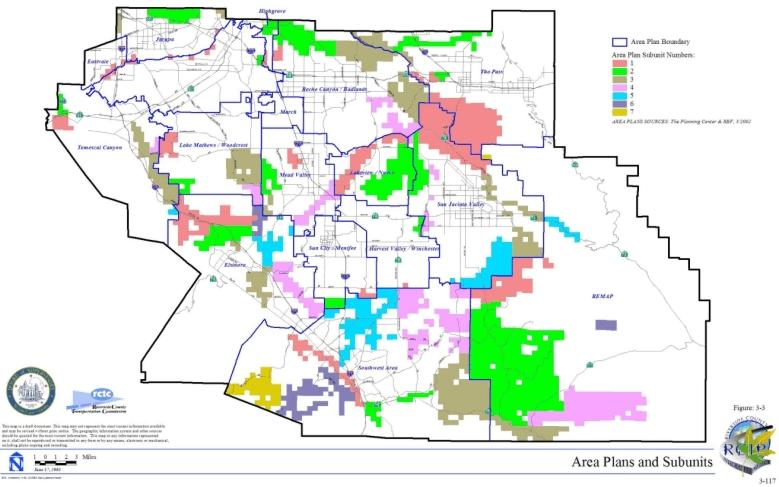
3.3 AREA PLANS
3.3.1 Introduction to Area Plans
Methods
| TABLE 3-2 TARGET ACREAGE RANGES BY AREA PLAN SUBUNIT |
|||
|---|---|---|---|
| SUBUNIT | Range of Acres within Additional Reserve Lands | ||
| Low | Midpoint | High | |
| Cities of Riverside and Norco | |||
| SU1 - Santa Ana River South | 75 | 140 | 200 |
| SU2 - Sycamore Canyon West | 15 | 25 | 40 |
| Subtotal within Area Plan | 90 | 165* | 240 |
| Eastvale Area Plan | |||
| SU1 - Santa Ana River Central | 145 | 220 | 290 |
| Subtotal within Area Plan | 145 | 220* | 290 |
| Elsinore Area Plan | |||
| SU1 - Estelle Mountain/Indian Canyon | 4,100 | 5,065 | 6,030 |
| SU2 - Alberhill | 1,760 | 2,385 | 3,010 |
| SU3 - Elsinore | 925 | 1,370 | 1,815 |
| SU4 - Sedco Hills | 2,415 | 3,130 | 3,845 |
| SU5 - Ramsgate | 1,645 | 2,090 | 2,535 |
| SU6 - Steele Peak | 855 | 1,070 | 1,280 |
| Subtotal within Area Plan | 11,700 | 15,110* | 18,515 |
| Harvest Valley / Winchester Area Plan | |||
| SU1 - French Valley/Diamond Valley Lake Connection | 130 | 135 | 145 |
| SU2 - Hemet Vernal Pool West | 300 | 380 | 460 |
| Subtotal within Area Plan | 430 | 515* | 605 |
| Highgrove Area Plan | |||
| SU1 - Sycamore Canyon/Box Springs Central | 95 | 140 | 180 |
| SU2 - Springbrook Wash North | 250 | 370 | 495 |
| Subtotal within Area Plan | 345 | 510* | 675 |
| Jurupa Area Plan | |||
| SU1 - Santa Ana River North | 135 | 190 | 245 |
| SU2 - Jurupa Mountains✝ | 445 | 750 | 1,055 |
| SU3 - Delhi Sands Area✝ | 310 | 440 | 570 |
| Subtotal within Area Plan | 890 | 1,380* | 1,870 |
| Lake Mathews / Woodcrest Area Plan | |||
| SU1 - Lake Mathews East | 1,140 | 1,410 | 1,680 |
| SU2 - Dawson Canyon | 815 | 950 | 1,090 |
| SU3 - Gavilan Hills West | 1,175 | 1,825 | 2,475 |
| SU4 - Good Hope West | 85 | 155 | 225 |
| Subtotal within Area Plan | 3,215 | 4,340* | 5,470 |
| Lakeview / Nuevo Area Plan | |||
| SU1 - San Jacinto River, Middle Reach | 2,605 | 3,315 | 4,025 |
| SU2 - Lakeview Mountains West | 4,045 | 5,130 | 6,210 |
| Subtotal within Area Plan | 6,650 | 8,445* | 10,235 |
| Mead Valley Area Plan | |||
| SU1 - Motte/Rimrock | 315 | 455 | 590 |
| SU2 - Gavilan Hills East | 485 | 750 | 1,015 |
| SU3 - Good Hope East | 290 | 390 | 495 |
| SU4 - San Jacinto River Lower | 795 | 1,165 | 1,535 |
| Subtotal within Area Plan | 1,885 | 2,760* | 3,635 |
| Riverside Extended Mountain Area Plan | |||
| SU1 - Cactus Valley | 6,020 | 6,805 | 7,590 |
| SU2 - Wilson Valley/Sage | 26,205 | 30,815 | 35,425 |
| SU3 - Temecula & Cottonwood Creeks | 1,480 | 2,115 | 2,745 |
| SU4 - Tule Creek/Anza Valley | 6,415 | 8,515 | 10,615 |
| SU5 - Upper San Jacinto River | 750 | 985 | 1,220 |
| SU6 - Tripp Flats | 520 | 680 | 840 |
| SU7 - Southern Badlands East | 10 | 20 | 35 |
| Subtotal within Area Plan | 41,400 | 49,935* | 58,470 |
| Reche Canyon / Badlands Area Plan | |||
| SU1 - Box Springs East | 175 | 265 | 350 |
| SU2 - Reche Canyon | 1,215 | 1,915 | 2,615 |
| SU3 - Badlands North | 8,270 | 9,580 | 10,895 |
| SU4 - San Jacinto Wildlife Area/Mystic Lake | 860 | 1,305 | 1,750 |
| Subtotal within Area Plan | 10,520 | 13,065* | 15,610 |
| San Jacinto Valley Area Plan | |||
| SU1 - Gilman Springs | 3,540 | 5,030 | 6,520 |
| SU2 - Lakeview Mountains East | 1,305 | 1,730 | 2,150 |
| SU3 - Upper San Jacinto River/Bautista Creek | 2,085 | 2,980 | 3,875 |
| SU4 - Hemet Vernal Pool Areas East | 940 | 1,190 | 1,445 |
| SU5 - Mica Butte | 3,670 | 4,570 | 5,475 |
| Subtotal within Area Plan | 11,540 | 15,500* | 19,465 |
| Southwest Area Plan | |||
| SU1 - Murrieta Creek | 640 | 1,055 | 1,465 |
| SU2 - Temecula & Pechanga Creeks | 365 | 600 | 840 |
| SU3 - Vail Lake | 10,065 | 11,500 | 12,930 |
| SU4 - Cactus Valley/SWRC-MSR/Johnson Ranch | 4,395 | 6,180 | 7,970 |
| SU5 - French Valley/Lower Sedco Hills | 4,360 | 5,880 | 7,395 |
| SU6 - Santa Rosa Plateau | 1,285 | 2,100 | 2,915 |
| SU7 - Tenaja Corridor | 1,390 | 2,115 | 2,845 |
| Subtotal within Area Plan | 22,500 | 29,430* | 36,360 |
| Sun City / Menifee Valley Area Plan | |||
| SU1 - Warm Springs Creek/French Valley Area | 395 | 480 | 565 |
| SU2 - Lower Sedco Hills | 725 | 875 | 1,020 |
| Subtotal within Area Plan | 1,120 | 1,355* | 1,585 |
| Temescal Canyon Area Plan | |||
| SU1 - Santa Ana River/Santa Ana Mountains | 250 | 400 | 550 |
| SU2 - Prado Basin | 200 | 300 | 395 |
| SU3 - Temescal Wash West | 2,790 | 3,600 | 4,415 |
| SU4 - La Sierra Hills/Lake Mathews West | 210 | 285 | 355 |
| SU5 - Temescal/Santa Ana Mountains | 35 | 60 | 85 |
| Subtotal within Area Plan | 3,485 | 4,645* | 5,800 |
| The Pass Area Plan | |||
| SU1 - Potrero/Badlands | 5,570 | 7,420 | 9,275 |
| SU2 - Badlands/San Bernardino National Forest | 1,105 | 1,650 | 2,195 |
| SU3 - San Timoteo Creek | 1,865 | 2,160 | 2,455 |
| Subtotal within Area Plan | 8,540 | 11,230* | 13,925 |
| * Totals do not include acreage adjustments for planned roadways. ✝ See also species-specific conservation objectives 1A, 1B and 1C for Delhi Sands flower-loving fly in Table 9-2 of this document for target acreages. |
|||
Results
Criteria Review Consistency Process
Criteria Review Consistency Prior to MSHCP Adoption
| Project Name* | Area Plan/Area Plan Subunit | Core or Linkage Designation | Cell(s) or Cell Group(s) | Acreage Conserved (acres) |
Approval Citation |
|---|---|---|---|---|---|
| TR30052 | SWAP/SU2 | Proposed Constrained Linkage 24 | 7274, 7275 | 13.9 | Board of Supervisors 9/25/01 |
| SP284 (Planning Area #1) APNs: 467-240-044, 047 and 049 |
SWAP/SU5 | Proposed Constrained Linkage 18 | 5572 | 17.7 | Board of Supervisors 3/13/01 |
| SP310 | SWAP/SU 4 and 5 | Proposed Constrained Linkage 17 | 5067, 5068, 5170, 5169 | 54.9 | Board of Supervisors 12/18/01 |
| TR29114/PM30239 | SWAP/SU5 | Proposed Constrained Linkage 18 | 5477 | 28.5 | Board of Supervisors 12/11/01 |
| TR29484/GPA521 | SWAP/SU5 | Proposed Core 2 | 5570 | 12.4 | Board of Supervisors 8/28/01 |
| PM29704 | Sun City/Menifee/ SU1 | Proposed Core 2 | 5066 | 9.0 | Board of Supervisors 4/17/02 |
| PM29228 | Sun City/Menifee SU1 | Proposed Core 2 | 5165 | 65.0 | Board of Supervisors 7/5/01 |
| SP323 | Highgrove SU2 |
Proposed Linkage 4 and Existing Noncontiguous Habitat Block A | 97, 101, 146, 148, 197 | 251.4 | Board of Supervisors 4/10/01 |
| SP327 | Lake Mathews/ SU2 Elsinore/SU1 Temescal Cyn/ SU3 |
Proposed Extension of Existing Core 2 | 3037, 3040, 3041, 3144, 3145, 3146, 3246, 3248, 3349, 3350, 3448 | 580.0 onsite 445.0 offsite |
MOU between County of Riverside and Sunny Sage LLC, Board of Supervisors 6/10/03 |
3.3.2 Eastvale Area Plan
➤ Target Acreages
➤ Applicable Cores and Linkages
➤ Area Plan Subunits
TABLE 3-3
CRITERIA FOR EASTVALE AREA PLAN
| Sub Unit |
Cell Group | Quadrat Number |
USGS Section | Quarter Section |
Criteria |
|---|---|---|---|---|---|
| SUBUNIT 1 - Santa Ana River Central | |||||
| 1 | 698 | 31 | NE | Conservation within this Cell will contribute to assembly of Existing Core A. Conservation within this Cell will focus on riparian scrub, woodland and forest and water habitats associated with Santa Ana River. Areas conserved within this Cell will be connected to riparian habitat proposed for conservation to the south in Cell #788 and to the east in Cell #699 of the Jurupa Area Plan. Conservation within this Cell will range from 35%-45% of the southeastern portion of the Cell. | |
| 1 | 786 | 36 | SE | Conservation within this Cell will contribute to assembly of Existing Core A. Conservation within this Cell will focus on riparian scrub, woodland and forest and water habitats associated with Santa Ana River. Areas conserved within this Cell will be connected to riparian habitat proposed for conservation to the south in Cell #876 and to the southwest in Cell #875. Conservation within this Cell will range from 20%-30% of the southern portion of the Cell. | |
| 1 | 788 | 31 | SE | Conservation within this Cell will contribute to assembly of Existing Core A. Conservation within this Cell will focus on riparian scrub, woodland and forest and water habitats associated with Santa Ana River. Areas conserved within this Cell will be connected to riparian habitat proposed for conservation to the north in Cell #698 and to the northwest in Cell #699 of the Jurupa Area Plan. Conservation within this Cell will range from 20%-30% of the northwestern portion of the Cell. | |
| 1 | 875 | 01 | NW | Conservation within this Cell will contribute to assembly of Existing Core A. Conservation within this Cell will focus on riparian scrub, woodland and forest and water habitats associated with Santa Ana River. Areas conserved within this Cell will be connected to riparian habitat proposed for conservation to the south in Cell #965, to the east in Cell #876 and to the portions of these Cells within the City of Norco. Conservation within this Cell will range from 10%-20% of the southern and eastern portion of the Cell. | |
| 1 | 876 | 01 | NE | Conservation within this Cell will contribute to assembly of Existing Core A. Conservation within this Cell will focus on riparian scrub, woodland and forest and water habitats associated with Santa Ana River. Areas conserved within this Cell will be connected to riparian habitat proposed for conservation to the north in Cell #786 and to the west in Cell #875 and to the portions of Cell #875 within the City of Norco. Conservation within this Cell will range from 25%-35% of the northern portion of the Cell. | |
| 1 | 964 | 02 | SE | Conservation within this Cell will contribute to assembly of Existing Core A. Conservation within this Cell will focus on riparian scrub, woodland and forest and water habitats associated with Santa Ana River. Areas conserved within this Cell will be connected to riparian habitat proposed for conservation to the east in Cell #965 and to the portion of Cell #964 within the City of Norco. Conservation within this Cell will be approximately 5% of the northeastern portion of the Cell. | |
| 1 | 965 | 01 | SW | Conservation within this Cell will contribute to assembly of Existing Core A. Conservation within this Cell will focus of riparian scrub, woodland and forest and water habitats associated with Santa Ana River. Areas conserved within this Cell will be connected to riparian habitat proposed for conservation to the north in Cell #875, to the west in Cell #964 and to the portions of these Cells within the City of Norco. Conservation within this Cell will be approximately 5% of the northwestern portion of the Cell. | |
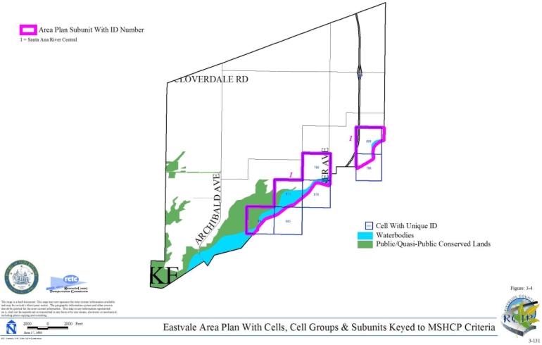
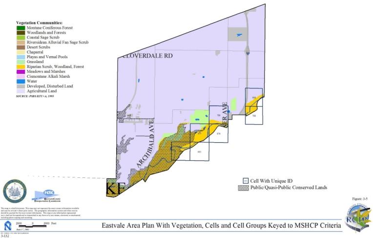
3.3.3 Elsinore Area Plan
➤ Target Acreages
➤ Applicable Cores and Linkages
➤ Area Plan Subunits
TABLE 3-4
CRITERIA FOR ELSINORE AREA PLAN
| Sub Unit |
Cell Group | Quadrat Number |
USGS Section | Quarter Section |
Criteria |
|---|---|---|---|---|---|
| SUBUNIT 1 - Estelle Mountain/Indian Canyon | |||||
| 1 | A | 3448 | 12 | NE | Conservation within this Cell Group will contribute to assembly of Proposed Extension of Existing Core 2. Conservation within this Cell Group will focus on riparian scrub, woodland, forest and Riversidean alluvial fan sage scrub habitat associated with Temescal Wash and adjacent upland habitat. Areas conserved within this Cell Group will be connected to riparian and upland habitat proposed for conservation in Cell #3351 to the north, to riparian habitat proposed for conservation in Cell Group C to the south and to coastal sage scrub and grassland habitat proposed for conservation in Cell #3450 to the east. Conservation within this Cell Group will range from 75%-85% of the Cell Group focusing in the eastern portion of the Cell Group. |
| 1 | A | 3449 | 07 | NW | |
| 1 | C | 3547 | 07 | SW | Conservation within this Cell Group east of I-15 will contribute to assembly of Proposed Extension of Existing Core 2 and conservation within this Cell Group west of I-15 will contribute to assembly of Proposed Linkage 1. Conservation within this Cell Group will focus on Riversidean alluvial fan sage scrub habitat associated with Temescal Wash and adjacent upland habitat. Areas conserved within this Cell Group will be connected to riparian and upland habitat proposed for conservation in Cell Group A to the north, to Riversidean alluvial fan sage scrub habitat proposed for conservation in Cell #3745 to the south and to upland habitat proposed for conservation in Cell Group D to the east. Conservation within this Cell Group will range from 55%-65% of the Cell Group focusing in the southern and northeastern portions of the Cell Group. |
| 1 | C | 3645 | 18 | NW | |
| 1 | D | 3548 | 07 | SE | Conservation within this Cell Group east of I-15 will contribute to assembly of Proposed Extension of Existing Core 2 and conservation within this Cell Group west of I-15 will contribute to assembly of Proposed Linkage 1 and Proposed Constrained Linkage 5. Conservation within this Cell Group east of I-15 will focus on riparian scrub, woodland and forest habitat associated with Temescal Wash and adjacent upland habitat. Conservation within this Cell Group west of I-15 will focus on chaparral habitat in a mosaic with other upland habitat. Areas conserved within this Cell Group will be connected to riparian and upland habitat proposed for conservation in Cell Groups C to the west, E to the east, K to the south and in Cell #3450 to the north. Conservation within this Cell Group will range from 80%-90% of the Cell Group focusing in the southern and northern portions of the Cell Group. |
| 1 | D | 3646 | 18 | NE | |
| 1 | E | 3549 | 08 | SW | Conservation within this Cell Group east of I-15 will contribute to assembly of Proposed Extension of Existing Core 2 and conservation within this Cell Group west of I-15 will contribute to assembly of Proposed Constrained Linkage 5. Conservation within this Cell Group east of I-15 will focus on riparian scrub, woodland and forest habitat associated with Temescal Wash and adjacent upland habitat. Conservation within this Cell Group west of I-15 will focus on chaparral habitat. Areas conserved within this Cell Group will be connected to riparian and upland habitat proposed for conservation in Cell Group F to the east and in Cell Group D to the west. Conservation within this Cell Group will range from 40%-50% of the Cell Group focusing in the northern portion of the Cell Group. |
| 1 | E | 3647 | 17 | NW | |
| 1 | F | 3550 | 08 | SE | Conservation within this Cell Group will contribute to assembly of Proposed Extension of Existing Core 2. Conservation within this Cell Group will focus on riparian habitat associated with Temescal Wash and adjacent coastal sage scrub and grassland habitat. Areas conserved within this Cell Group will be connected to riparian habitat proposed for conservation in Cell #3748 to the south and to riparian and coastal sage scrub habitat proposed for conservation in Cell Group E to the west. Conservation within this Cell Group will range from 65%-75% of the Cell Group focusing in the northern portion of the Cell Group. |
| 1 | F | 3648 | 17 | NE | |
| 1 | H | 3649 | 16 | NW | Conservation within this Cell Group will contribute to assembly of Proposed Constrained Linkage 6. Conservation within this Cell Group will focus on riparian habitat associated with Temescal Wash. Areas conserved within this Cell Group will be connected to riparian habitat proposed for conservation in Cell Group I to the east and in Cell #3748 to the west. Conservation within this Cell Group will range from 5%-15% of the Cell Group focusing in the southern portion of the Cell Group. |
| 1 | H | 3749 | 16 | SW | |
| 1 | I | 3650 | 16 | NE | Conservation within this Cell Group will contribute to assembly of Proposed Constrained Linkage 6. Conservation within this Cell Group will focus on riparian habitat associated with Temescal Wash. Areas conserved within this Cell Group will be connected to riparian habitat proposed for conservation in Cell Group J to the east and in Cell Group H to the west. Conservation within this Cell Group will be approximately 5% of the Cell Group focusing in the southern portion of the Cell Group. |
| 1 | I | 3750 | 16 | SE | |
| 1 | J | 3457 | 11 | NW | Conservation within this Cell Group will contribute to assembly of Proposed Core 1. Conservation within this Cell Group will focus on coastal sage scrub, chaparral, grassland, riparian scrub, woodland and forest habitat. Areas conserved within this Cell Group will be connected to upland habitat proposed for conservation in Cell #3853 and #3855, and Cell Group O all to the south, to coastal sage scrub habitat proposed for conservation in Cell Group L to the east, to riparian habitat proposed for conservation in Cell Group I to the west and to existing PQP Lands to the north and west. Conservation within this Cell Group will range from 75%-85% of the Cell Group focusing in the western and northern portions of the Cell Group. |
| 1 | J | 3458 | 11 | NE | |
| 1 | J | 3555 | 11 | SW | |
| 1 | J | 3556 | 11 | SE | |
| 1 | J | 3651 | 15 | NE | |
| 1 | J | 3652 | 14 | NW | |
| 1 | J | 3653 | 15 | NW | |
| 1 | J | 3654 | 14 | NE | |
| 1 | J | 3751 | 15 | SW | |
| 1 | J | 3752 | 15 | SE | |
| 1 | J | 3753 | 14 | SW | |
| 1 | J | 3756 | 14 | SE | |
| 1 | K | 3746 | 18 | SE | Conservation within this Cell Group will contribute to assembly of Proposed Linkage 1. Conservation within this Cell Group will focus on chaparral, Riversidean alluvial fan sage scrub, riparian scrub, woodland and forest habitat and agricultural land. Areas conserved within this Cell Group will be connected to chaparral and Riversidean alluvial fan sage scrub proposed for habitat in Cell Group D to the north, to chaparral habitat proposed for conservation in Cell #3745 and #3844 both to the west and to chaparral, woodland and forest habitat proposed for conservation in Cell Group R to the south. Conservation within this Cell Group will range from 70%-80% of the Cell Group focusing in the northwestern portion of the Cell Group. |
| 1 | K | 3846 | 19 | NE | |
| 1 | L | 3658 | 13 | NW | Conservation within this Cell Group will contribute to assembly of Proposed Core 1. Conservation within this Cell Group will focus on coastal sage scrub, chaparral and grassland habitat. Areas conserved within this Cell Group will be connected to coastal sage scrub habitat proposed for conservation in Cell Group J to the west, to upland habitat proposed for conservation in Cell Groups, P and Q to the south and to existing PQP Lands also to the south. Conservation within this Cell Group will range from 75%-85% of the Cell Group focusing in the western portion of the Cell Group. |
| 1 | L | 3671 | 17 | NW | |
| 1 | L | 3672 | 13 | NE | |
| 1 | L | 3673 | 18 | NE | |
| 1 | L | 3685 | 18 | NW | |
| 1 | L | 3759 | 13 | SW | |
| 1 | L | 3767 | 13 | SE | |
| 1 | L | 3774 | 18 | SE | |
| 1 | L | 3775 | 18 | SW | |
| 1 | N | 3849 | 21 | NW | Conservation within this Cell Group will contribute to assembly of Proposed Core 1. Conservation within this Cell Group will focus on Riversidean alluvial fan sage scrub and chaparral habitat. Areas conserved within this Cell Group will be connected to chaparral and Riversidean alluvial fan sage scrub habitat proposed for conservation in Cell Group S to the south and to chaparral habitat proposed for conservation in Cell Group H to the north. Conservation within this Cell Group will range from 35%-45% of the Cell Group focusing in the western portion of the Cell Group. |
| 1 | N | 3850 | 21 | NE | |
| 1 | R | 3946 | 19 | SW | Conservation within this Cell Group will contribute to assembly of Proposed Core 1. Conservation within this Cell Group will focus on chaparral, riparian scrub, woodland and forest habitat. Areas conserved within this Cell Group will be connected to chaparral and Riversidean alluvial fan sage scrub habitat proposed for conservation in Cell Group K to the north and to chaparral, woodland and forest habitat proposed for conservation in Cell #3949 to the east and in Cell #4050 to the south. Conservation within this Cell Group will range from 75%-85% of the Cell Group focusing in the southeastern portion of the Cell Group. |
| 1 | R | 3948 | 19 | SE | |
| 1 | S | 3951 | 21 | SW | Conservation within this Cell Group will contribute to assembly of Proposed Core 1. Conservation within this Cell Group will focus on chaparral and Riversidean alluvial fan sage scrub habitat. Areas conserved within this Cell Group will be connected to chaparral and Riversidean alluvial fan sage scrub habitat proposed for conservation in Cell Group N to the north, in Cell #3950 to the west and in Cell #4054 to the south. Conservation within this Cell Group will range from 45%-55% of the Cell Group focusing in the western portion of the Cell Group. |
| 1 | S | 3952 | 21 | SE | |
| 1 | 3249 | 06 | NW | Conservation within this Cell will contribute to assembly of Proposed Extension of Existing Core 2. Conservation within this Cell will focus on coastal sage scrub habitat. Areas conserved within this Cell will be connected to coastal sage scrub and riparian habitat proposed for conservation in Cell Group H in the Elsinore Area Plan to the west. Conservation within this Cell will be approximately 5% of the Cell focusing in the western central portion of the Cell. | |
| 1 | 3351 | 06 | SW | Conservation within this Cell will contribute to assembly of Proposed Extension of Existing Core 2. Conservation within this Cell will focus on riparian habitat associated with Temescal Wash and adjacent coastal sage scrub and grassland habitat. Areas conserved within this Cell will be connected to upland and riparian habitat proposed for conservation in Cell Group A to the south and in Cell Group I in the Elsinore Area Plan to the west. Conservation within this Cell will range from 45%-55% of the Cell focusing in the southern half of the Cell. | |
| 1 | 3450 | 07 | NE | Conservation within this Cell will contribute to assembly of Proposed Extension of Existing Core 2. Conservation within this Cell will focus on coastal sage scrub and grassland habitat. Areas conserved within this Cell will be connected to upland and riparian habitat proposed for conservation in Cell Group D to the south and to upland habitat proposed for conservation in Cell Group A to the west. Conservation within this Cell will range from 45%-55% of the Cell focusing in the southern half of the Cell. | |
| 1 | 3744 | 13 | SE | Conservation within this Cell will contribute to assembly of Proposed Linkage 1. Conservation within this Cell will focus on chaparral, Riversidean alluvial fan sage scrub, woodland and forest habitat. Areas conserved within this Cell will be connected chaparral and Riversidean alluvial fan sage scrub habitat proposed for conservation in Cell #3745 to the east. Conservation within this Cell will range from 35%-45% of the Cell focusing in the northern half of the Cell. | |
| 1 | 3745 | 18 | SW | Conservation within this Cell will contribute to assembly of Proposed Linkage 1. Conservation within this Cell will focus on chaparral and Riversidean alluvial fan sage scrub habitat. Areas conserved within this Cell will be connected to chaparral and Riversidean alluvial fan sage scrub habitat proposed for conservation in Cell #3744 to the west and in Cell Group C to the north, to riparian scrub, woodland and forest habitat and agricultural land proposed for conservation in Cell Group K to the east and to chaparral and adjacent habitat proposed for conservation in Cell #3844 to the south. Conservation within this Cell will be approximately 5% of the Cell focusing in the northwestern and southeastern portions of the Cell. | |
| 1 | 3748 | 17 | SE | Conservation within this Cell will contribute to assembly of Proposed Constrained Linkage 6. Conservation within this Cell will focus on riparian habitat associated with Temescal Wash and adjacent chaparral and coastal sage scrub habitat. Areas conserved within this Cell will be connected to upland and riparian habitat proposed for conservation in Cell Groups F to the north, H to the east and N to the southeast. Conservation within this Cell will range from 40%-50% of the Cell focusing in the eastern portion of the Cell. | |
| 1 | 3844 | 19 | NW | Conservation within this Cell will contribute to assembly of Proposed Linkage 1. Conservation within this Cell will focus on chaparral and adjacent habitat. Areas conserved within this Cell will be connected to chaparral habitat proposed for conservation in Cell #3745 to the north and to chaparral habitat and agricultural land proposed for conservation in Cell Group K to the east. Conservation within this Cell will be approximately 5% of the Cell focusing in the northeastern portion of the Cell. | |
| 1 | 3949 | 20 | SW | Conservation within this Cell will contribute to assembly of Proposed Linkage 1. Conservation within this Cell will focus on chaparral, woodland and forest habitat. Areas conserved within this Cell will be connected to chaparral habitat proposed for conservation in Cell #3950 to the east and to chaparral, woodland and forest habitat proposed for conservation in Cell Group R to the west. Conservation within this Cell will range from 65%-75% of the Cell focusing in the southern portion of the Cell. | |
| 1 | 3950 | 20 | SE | Conservation within this Cell will contribute to assembly of Proposed Linkage 1. Conservation within this Cell will focus on chaparral, Riversidean alluvial fan sage scrub, woodland and forest habitat. Areas conserved within this Cell will be connected to chaparral habitat proposed for conservation in Cell #3949 to the west and to chaparral and Riversidean alluvial fan sage scrub habitat proposed for conservation in Cell Group S to the east. Conservation within this Cell will range from 55%-65% of the Cell focusing in the southern portion of the Cell. | |
| 1 | 4048 | 30 | NW | Conservation within this Cell will contribute to assembly of Proposed Linkage 1. Conservation within this Cell will focus on chaparral habitat. Areas conserved within this Cell will be connected to chaparral habitat proposed for conservation in Cell #4050 to the east and in Cell #4148 to the south. Conservation within this Cell will range from 15%-25% of the Cell focusing in the southeastern portion of the Cell. | |
| 1 | 4050 | 30 | NE | Conservation within this Cell will contribute to assembly of Proposed Linkage 1. Conservation within this Cell will focus on chaparral, woodland and forest habitat. Areas conserved within this Cell will be connected to chaparral habitat proposed for conservation in Cell #4048 to the west. Conservation within this Cell will range from 45%-55% of the Cell focusing in the western half of the Cell. | |
| 1 | 4148 | 30 | SW | Conservation within this Cell will contribute to assembly of Proposed Linkage 1. Conservation within this Cell will focus on chaparral habitat. Areas conserved within this Cell will be connected to chaparral habitat proposed for conservation in Cell #4048 to the north. Conservation within this Cell will range from 20%-30% of the Cell focusing in the northeastern portion of the Cell. | |
| SUBUNIT 2 - Alberhill | |||||
| 2 | O | 3856 | 23 | NE | Conservation within this Cell Group will contribute to assembly of Proposed Core 1. Conservation within this Cell Group will focus on riparian scrub, woodland and forest habitat associated with Alberhill Creek and adjacent coastal sage scrub and chaparral habitat. Areas conserved within this Cell Group will be connected to coastal sage scrub, riparian scrub, woodland and forest habitat proposed for conservation in Cell Group J to the north, in Cell #3853 to the west and in Cell Group V to the south, and to chaparral and coastal sage scrub habitat proposed for conservation in Cell #3964 also to the south. Conservation within this Cell Group will range from 60%-70% of the Cell Group focusing in the western portion of the Cell Group. |
| 2 | O | 3859 | 24 | NW | |
| 2 | P | 3862 | 24 | NE | Conservation within this Cell Group will contribute to assembly of Proposed Core 1. Conservation within this Cell Group will focus on coastal sage scrub and chaparral habitat. Areas conserved within this Cell Group will be connected to upland habitat proposed for conservation in Cell Groups L to the north and Q to the east and in Cell #3966 and #3970 both to the south. Conservation within this Cell Group will range from 55%-65% of the Cell Group focusing in the eastern portion of the Cell Group. |
| 2 | P | 3864 | 19 | NW | |
| 2 | Q | 3869 | 19 | NE | Conservation within this Cell Group will contribute to assembly of Proposed Core 1. Conservation within this Cell Group will focus on chaparral, coastal sage scrub, riparian scrub, woodland and forest habitat. Areas conserved within this Cell Group will be connected to chaparral and coastal sage scrub habitat proposed for conservation in Cell Group P to the west, to upland habitat proposed for conservation in Cell #3970 also to the west, to chaparral habitat proposed for conservation in Cell Group L to the north, and to coastal sage scrub habitat proposed for conservation in Cell Group M to the east. Conservation within this Cell Group will range from 75%-85% of the Cell Group focusing in the northern portion of the Cell Group. |
| 2 | Q | 3976 | 19 | SE | |
| 2 | T | 3953 | 22 | SW | Conservation within this Cell Group will contribute to assembly of Proposed Core 1. Conservation within this Cell Group will focus on chaparral and coastal sage scrub habitat. Areas conserved within this Cell Group will be connected to chaparral and adjacent habitat proposed for conservation in Cell #4054 to the west, to coastal sage scrub habitat proposed for conservation in Cell #4155 to the south, and to chaparral and coastal sage scrub habitat proposed for conservation in Cell Group U to the east. Conservation within this Cell Group will range from 50%-60% of the Cell Group focusing in the southeastern portion of the Cell Group. |
| 2 | T | 4055 | 27 | NW | |
| 2 | U | 3954 | 22 | SE | Conservation within this Cell Group will contribute to assembly of Proposed Core 1. Conservation within this Cell Group will focus on chaparral and recovery of coastal sage scrub habitat. Areas conserved within this Cell Group will be connected to chaparral and coastal sage scrub habitat proposed for conservation in Cell Group T to the west and in Cell #4156 to the south and to chaparral and grassland habitat proposed for conservation in Cell #4057 to the east. Conservation within this Cell Group will range from 40%-50% of the Cell Group focusing in the western and central portions of the Cell Group. |
| 2 | U | 4056 | 27 | NE | |
| 2 | V | 3957 | 23 | SW | Conservation within this Cell Group will contribute to assembly of Proposed Core 1. Conservation within this Cell Group will focus on riparian scrub, woodland and forest habitat associated with Alberhill Creek and recovery of adjacent coastal sage scrub habitat. Areas conserved within this Cell Group will be connected to coastal sage scrub, riparian scrub, woodland and forest habitat proposed for conservation in Cell Group O to the north and in Cell #3964 to the east and to coastal sage scrub habitat proposed for conservation in Cell Group W to the south. Conservation within this Cell Group will range from 60%-70% of the Cell Group focusing in the eastern portion of the Cell Group. |
| 2 | V | 3959 | 23 | SE | |
| 2 | W | 4060 | 26 | NE | Conservation within this Cell Group will contribute to assembly of Proposed Core 1. Conservation within this Cell Group will focus on riparian scrub, woodland and forest habitat associated with Alberhill Creek and adjacent coastal sage scrub and grassland habitat. Areas conserved within this Cell Group will be connected to coastal sage scrub, riparian scrub, woodland and forest habitat proposed for conservation in Cell #3964 to the north, to coastal sage scrub habitat proposed for conservation in Cell #4057 to the west, and to grassland, riparian scrub, woodland and forest habitat proposed for conservation in Cell #4166 to the south. Conservation within this Cell Group will range from 80%-90% of the Cell Group focusing in the northwestern portion of the Cell Group. |
| 2 | W | 4067 | 25 | NW | |
| 2 | W | 4070 | 25 | NE | |
| 2 | 3853 | 23 | NW | Conservation within this Cell will contribute to assembly of Proposed Core 1. Conservation within this Cell will focus on riparian scrub, woodland and forest habitat associated with Alberhill Creek and recovery of adjacent coastal sage scrub habitat. Areas conserved within this Cell will be connected to coastal sage scrub, riparian scrub, woodland and forest habitat proposed for conservation in Cell Groups J to the north and O to the east. Conservation within this Cell will range from 80%-90% of the Cell focusing in the northeastern portion of the Cell. | |
| 2 | 3854 | 22 | NW | Conservation within this Cell will contribute to assembly of Proposed Core 1. Conservation within this Cell will focus on recovery of coastal sage scrub habitat. Areas conserved within this Cell will be connected to coastal sage scrub habitat proposed for conservation in Cell Group J to the north and in Cell #3855 to the east. Conservation within this Cell will range from 10%-20% of the Cell focusing in the northeastern portion of the Cell. | |
| 2 | 3855 | 22 | NE | Conservation within this Cell will contribute to assembly of Proposed Core 1. Conservation within this Cell will focus on recovery of coastal sage scrub habitat. Areas conserved within this Cell will be connected to coastal sage scrub, riparian scrub, woodland and forest habitat proposed for conservation in Cell Group J to the north. Conservation within this Cell will range from 25%-35% of the Cell focusing in the northern portion of the Cell. | |
| 2 | 3964 | 24 | SW | Conservation within this Cell will contribute to assembly of Proposed Core 1. Conservation within this Cell will focus on riparian scrub, woodland and forest habitat associated with Alberhill Creek and adjacent coastal sage scrub and chaparral habitat. Areas conserved within this Cell will be connected to coastal sage scrub, riparian scrub, woodland and forest habitat proposed for conservation in Cell Groups V to the west and W to the south and to chaparral and coastal sage scrub habitat proposed for conservation in Cell Group O to the north. Conservation within this Cell will range from 45%-55% of the Cell focusing in the western half of the Cell. | |
| 2 | 3966 | 24 | SE | Conservation within this Cell will contribute to assembly of Proposed Core 1. Conservation within this Cell will focus on coastal sage scrub and chaparral habitat. Areas conserved within this Cell will be connected to coastal sage scrub and chaparral habitat proposed for conservation in Cell Group P to the north and to upland habitat proposed for conservation in Cell #3970 to the east. Conservation within this Cell will range from 5%-15% of the Cell focusing in the northeastern portion of the Cell. | |
| 2 | 3970 | 19 | SW | Conservation within this Cell will contribute to assembly of Proposed Core 1. Conservation within this Cell will focus on coastal sage scrub habitat. Areas conserved within this Cell will be connected to chaparral habitat proposed for conservation in Cell Group P to the north and to coastal sage scrub habitat proposed for conservation in Cell #3966 to the west. Conservation within this Cell will range from 5%-15% of the Cell focusing in the northern portion of the Cell. | |
| 2 | 4054 | 28 | NE | Conservation within this Cell will contribute to assembly of Proposed Linkage 1. Conservation within this Cell will focus on chaparral and Riversidean alluvial fan sage scrub habitat. Areas conserved within this Cell will be connected to chaparral habitat proposed for conservation in Cell Groups S to the north and T to the east and to chaparral and Riversidean alluvial fan sage scrub habitat proposed for conservation in Cell #4154 to the south. Conservation within this Cell will range from 70%-80% of the Cell focusing in the northeastern portion of the Cell. | |
| 2 | 4057 | 26 | NW | Conservation within this Cell will contribute to assembly of Proposed Core 1. Conservation within this Cell will focus on coastal sage scrub, chaparral and grassland habitat. Areas conserved within this Cell will be connected to chaparral habitat proposed for conservation in Cell Group U to the west, to chaparral and grassland habitat proposed for conservation in Cell #4157 to the south and to coastal sage scrub habitat proposed for conservation in Cell Group W to the east. Conservation within this Cell will range from 80%-90% of the Cell focusing in the southeastern portion of the Cell. | |
| 2 | 4152 | 29 | SE | Conservation within this Cell will contribute to assembly of Proposed Linkage 1. Conservation within this Cell will focus on chaparral and Riversidean alluvial fan sage scrub habitat. Areas conserved within this Cell will be connected to chaparral and Riversidean alluvial fan sage scrub habitat proposed for conservation in Cell #4153 to the east. Conservation within this Cell will range from 15%-25% of the Cell focusing in the southeastern portion of the Cell. | |
| 2 | 4153 | 28 | SW | Conservation within this Cell will contribute to assembly of Proposed Linkage 1. Conservation within this Cell will focus on chaparral and Riversidean alluvial fan sage scrub habitat. Areas conserved within this Cell will be connected to chaparral and Riversidean alluvial fan sage scrub habitat proposed for conservation in Cell #4152 to the west, #4250 to the south and #4154 to the east. Conservation within this Cell will range from 60%-70% of the Cell focusing in the southern portion of the Cell. | |
| 2 | 4154 | 28 | SE | Conservation within this Cell will contribute to assembly of Proposed Linkage 1. Conservation within this Cell will focus on chaparral, Riversidean alluvial fan sage scrub and grassland habitat. Areas conserved within this Cell will be connected to chaparral and Riversidean alluvial fan sage scrub habitat proposed for conservation in Cell #4153 to the west, #4251 to the south and #4054 to the north. Conservation within this Cell will range from 75%-85% of the Cell focusing in the southeastern portion of the Cell. | |
| 2 | 4155 | 27 | SW | Conservation within this Cell will contribute to assembly of Proposed Core 1. Conservation within this Cell will focus on coastal sage scrub and chaparral habitat. Areas conserved within this Cell will be connected to coastal sage scrub habitat proposed for conservation in Cell Group T to the north and in Cell #4156 to the east. Conservation within this Cell will range from 20%-30% of the Cell focusing in the northeastern portion of the Cell. | |
| 2 | 4156 | 27 | SE | Conservation within this Cell will contribute to assembly of Proposed Core 1. Conservation within this Cell will focus on coastal sage scrub and chaparral habitat. Areas conserved within this Cell will be connected to coastal sage scrub habitat proposed for conservation in Cell #4155 to the west and to coastal sage scrub and chaparral habitat proposed for conservation in Cell Group U to the north and in Cell #4157 to the east. Conservation within this Cell will range from 65%-75% of the Cell focusing in the northeastern portion of the Cell. | |
| 2 | 4157 | 26 | SW | Conservation within this Cell will contribute to assembly of Proposed Core 1. Conservation within this Cell will focus on coastal sage scrub, chaparral and grassland habitat. Areas conserved within this Cell will be connected to coastal sage scrub and chaparral habitat proposed for conservation in Cell #4156 to the west and to chaparral and grassland habitat proposed for conservation in Cell #4057 to the north. Conservation within this Cell will range from 45%-55% of the Cell focusing in the western half of the Cell. | |
| 2 | 4250 | 33 | NW | Conservation within this Cell will contribute to assembly of Proposed Linkage 1. Conservation within this Cell will focus on chaparral and Riversidean alluvial fan sage scrub habitat. Areas conserved within this Cell will be connected to chaparral habitat proposed for conservation in Cell #4153 to the north and #4251 to the east. Conservation within this Cell will range from 45%-55% of the Cell focusing in the northern half of the Cell. | |
| 2 | 4251 | 33 | NE | Conservation within this Cell will contribute to assembly of Proposed Linkage 1. Conservation within this Cell will focus on chaparral, coastal sage scrub and Riversidean alluvial fan sage scrub habitat. Areas conserved within this Cell will be connected to chaparral habitat proposed for conservation in Cell #4154 to the north and #4250 to the west. Conservation within this Cell will range from 15%-25% of the Cell focusing in the northwestern portion of the Cell. | |
| SUBUNIT 3 - Elsinore | |||||
| 3 | 4166 | 25 | SW | Conservation within this Cell will contribute to assembly of Proposed Linkage 2. Conservation within this Cell will focus on meadow, marsh, riparian scrub, woodland and forest habitat along Alberhill Creek and adjacent grassland habitat. Areas conserved within this Cell will be connected to riparian scrub, woodland, forest and grassland habitat proposed for conservation in Cell Group W to the north and to meadow, marsh and grassland habitat proposed for conservation in Cell #4169 to the east. Conservation within this Cell will range from 15%-25% of the Cell focusing in the northeastern portion of the Cell. | |
| 3 | 4169 | 25 | SE | Conservation within this Cell will contribute to assembly of Proposed Linkage 2. Conservation within this Cell will focus on meadow and marsh habitat along Alberhill Creek and adjacent grassland habitat. Areas conserved within this Cell will be connected to meadow and marsh habitat proposed for conservation in Cell #4166 to the west and to meadow, marsh and grassland habitat proposed for conservation in Cell #4266 to the south. Conservation within this Cell will range from 10%-20% of the Cell focusing in the southwestern portion of the Cell. | |
| 3 | 4266 | 36 | NE | Conservation within this Cell will contribute to assembly of Proposed Linkage 2. Conservation within this Cell will focus on meadow, marsh, riparian scrub, woodland and forest habitat along Alberhill Creek and adjacent grassland habitat. Areas conserved within this Cell will be connected to meadow, marsh and grassland habitat proposed for conservation in Cell #4169 to the north. Conservation within this Cell will range from 30%-40% of the Cell focusing in the western portion of the Cell. | |
| 3 | 4646 | 09 | NW | Conservation within this Cell will contribute to assembly of Proposed Linkage 8. Conservation within this Cell will focus on riparian scrub, woodland and forest habitat along the San Jacinto River. Areas conserved within this Cell will be connected to riparian scrub, woodland and forest habitat proposed for conservation in Cell #4743 to the south and #4647 to the east. Conservation within this Cell will be approximately 5% of the Cell focusing in the southeastern portion of the Cell. | |
| 3 | 4647 | 09 | NE | Conservation within this Cell will contribute to assembly of Proposed Linkage 8. Conservation within this Cell will focus on riparian scrub, woodland and forest habitat along the San Jacinto River and adjacent coastal sage scrub habitat and on additional chaparral and coastal sage scrub habitat within the Cell. Areas conserved within this Cell will be connected to riparian scrub, woodland and forest habitat proposed for conservation in Cell #4646 to the west and #4648 to the east and to chaparral and coastal sage scrub habitat proposed for conservation in Cell Group C' to the north. Conservation within this Cell will range from 10%-20% of the Cell focusing in the southern and northeastern portions of the Cell. | |
| 3 | 4740 | 08 | SW | Conservation within this Cell will contribute to assembly of Proposed Extension of Existing Core 3. Conservation within this Cell will focus on grassland habitat associated with the San Jacinto River. Areas conserved within this Cell will be connected to grassland habitat proposed for conservation in Cell #4759 to the west, #4844 to the south and #4742 to the east. Conservation within this Cell will range from 70%-80% of the Cell focusing in the southeastern portion of the Cell. | |
| 3 | 4742 | 08 | SE | Conservation within this Cell will contribute to assembly of Proposed Extension of Existing Core 3. Conservation within this Cell will focus on grassland habitat associated with the San Jacinto River. Areas conserved within this Cell will be connected to grassland habitat proposed for conservation in Cell #4740 to the west, #4845 to the south and #4743 to the east. Conservation within this Cell will range from 30%-40% of the Cell focusing in the southern portion of the Cell. | |
| 3 | 4743 | 09 | SW | Conservation within this Cell will contribute to assembly of Proposed Extension of Existing Core 3 and Proposed Linkage 8. Conservation within this Cell will focus on riparian scrub, woodland, forest and grassland habitat associated with the San Jacinto River. Areas conserved within this Cell will be connected to riparian scrub, woodland and forest habitat proposed for conservation in Cell #4646 to the north and to grassland habitat proposed for conservation in Cell #4742 to the west and #4846 to the south. Conservation within this Cell will range from 45%-55% of the Cell focusing in the southern and northeastern portions of the Cell. | |
| 3 | 4759 | 07 | SE | Conservation within this Cell will contribute to assembly of Proposed Extension of Existing Core 3. Conservation within this Cell will focus on grassland habitat associated with the San Jacinto River. Areas conserved within this Cell will be connected to grassland habitat proposed for conservation in Cell #4740 to the east and #4843 to the south. Conservation within this Cell will range from 15%-25% of the Cell focusing in the eastern portion of the Cell. | |
| 3 | 4843 | 18 | NE | Conservation within this Cell will contribute to assembly of Proposed Extension of Existing Core 3. Conservation within this Cell will focus on grassland habitat associated with the San Jacinto River. Areas conserved within this Cell will be connected to grassland habitat proposed for conservation in Cell #4759 to the north and #4844 to the east. Conservation within this Cell will be approximately 5% of the Cell focusing in the northeastern portion of the Cell. | |
| 3 | 4844 | 17 | NW | Conservation within this Cell will contribute to assembly of Proposed Extension of Existing Core 3. Conservation within this Cell will focus on grassland habitat. Areas conserved within this Cell will be connected to grassland habitat proposed for conservation in Cell #4843 to the west, #4740 to the north and #4940 to the south. Conservation within this Cell will range from 35%-45% of the Cell focusing in the western portion of the Cell. | |
| 3 | 4845 | 17 | NE | Conservation within this Cell will contribute to assembly of Proposed Extension of Existing Core 3. Conservation within this Cell will focus on grassland habitat associated with the San Jacinto River. Areas conserved within this Cell will be connected to grassland habitat proposed for conservation in Cell #4742 to the north, #4846 to the east and #4939 to the south. Conservation within this Cell will range from 20%-30% of the Cell focusing in the northern and southeastern portions of the Cell. | |
| 3 | 4846 | 16 | NW | Conservation within this Cell will contribute to assembly of Proposed Extension of Existing Core 3. Conservation within this Cell will focus on grassland habitat associated with the San Jacinto River. Areas conserved within this Cell will be connected to grassland habitat proposed for conservation in Cell #4845 to the west, #4743 to the north and #4937 to the south. Conservation within this Cell will range from 65%-75% of the Cell focusing in the western portion of the Cell. | |
| 3 | 4937 | 16 | SW | Conservation within this Cell will contribute to assembly of Proposed Extension of Existing Core 3. Conservation within this Cell will focus on grassland habitat. Areas conserved within this Cell will be connected to grassland habitat proposed for conservation in Cell #4939 to the west and #4846 to the north. Conservation within this Cell will range from 30%-40% of the Cell focusing in the northwestern portion of the Cell. | |
| 3 | 4939 | 17 | SE | Conservation within this Cell will contribute to assembly of Proposed Extension of Existing Core 3. Conservation within this Cell will focus on grassland habitat. Areas conserved within this Cell will be connected to grassland habitat proposed for conservation in Cell #4845 to the north, #4937 to the east and 5033 to the south. Conservation within this Cell will range from 70%-80% of the Cell focusing in the northeastern portion of the Cell. | |
| 3 | 4940 | 17 | SW | Conservation within this Cell will contribute to assembly of Proposed Extension of Existing Core 3. Conservation within this Cell will focus on grassland habitat. Areas conserved within this Cell will be connected to grassland habitat proposed for conservation in Cell #4844 to the north. Conservation within this Cell will range from 15%-25% of the Cell focusing in the northwestern portion of the Cell. | |
| 3 | 5033 | 20 | NE | Conservation within this Cell will contribute to assembly of Proposed Extension of Existing Core 3. Conservation within this Cell will focus on grassland habitat. Areas conserved within this Cell will be connected to grassland habitat proposed for conservation in Cell #4939 to the north, #5036 to the west and #5140 to the south. Conservation within this Cell will range from 5%-15% of the Cell focusing in the southern and northeastern portions of the Cell. | |
| 3 | 5036 | 20 | NW | Conservation within this Cell will contribute to assembly of Proposed Extension of Existing Core 3. Conservation within this Cell will focus on grassland habitat. Areas conserved within this Cell will be connected to grassland habitat proposed for conservation in Cell #5038 to the west and #5033 to the east. Conservation within this Cell will range from 40%-50% of the Cell focusing in the southwestern portion of the Cell. | |
| 3 | 5038 | 19 | NE | Conservation within this Cell will contribute to assembly of Proposed Extension of Existing Core 3. Conservation within this Cell will focus on grassland habitat. Areas conserved within this Cell will be connected to grassland habitat proposed for conservation in Cell #5036 to the east. Conservation within this Cell will range from 35%-45% of the Cell focusing in the eastern central portion of the Cell. | |
| 3 | 5131 | 21 | SE | Conservation within this Cell will contribute to assembly of Proposed Extension of Existing Core 3. Conservation within this Cell will focus on grassland habitat. Areas conserved within this Cell will be connected to grassland habitat proposed for conservation in Cell #5137 to the west. Conservation within this Cell will range from 30%-40% of the Cell focusing in the southwestern portion of the Cell. | |
| 3 | 5137 | 21 | SW | Conservation within this Cell will contribute to assembly of Proposed Extension of Existing Core 3. Conservation within this Cell will focus on grassland habitat. Areas conserved within this Cell will be connected to grassland habitat proposed for conservation in Cell #5140 to the west, #5240 to the south and #5131 to the east. Conservation within this Cell will range from 65%-75% of the Cell focusing in the southern portion of the Cell. | |
| 3 | 5140 | 20 | SE | Conservation within this Cell will contribute to assembly of Proposed Extension of Existing Core 3. Conservation within this Cell will focus on grassland and chaparral habitat. Areas conserved within this Cell will be connected to grassland habitat proposed for conservation in Cell #5033 to the north and #5137 to the east. Conservation within this Cell will range from 40%-50% of the Cell focusing in the northeastern portion of the Cell. | |
| 3 | 5240 | 28 | NW | Conservation within this Cell will contribute to assembly of Proposed Extension of Existing Core 3. Conservation within this Cell will focus on grassland and coastal sage scrub habitat. Areas conserved within this Cell will be connected to grassland habitat proposed for conservation in Cell #5137 to the north and to coastal sage scrub habitat proposed for conservation in Cell #5342 to the south. Conservation within this Cell will range from 45%-55% of the Cell focusing in the northern and central portions of the Cell. | |
| 3 | 5342 | 28 | SW | Conservation within this Cell will contribute to assembly of Proposed Extension of Existing Core 3. Conservation within this Cell will focus on coastal sage scrub habitat. Areas conserved within this Cell will be connected to coastal sage scrub habitat proposed for conservation in Cell #5240 to the north. Conservation within this Cell will range from 5%-15% of the Cell focusing in the northern central portion of the Cell. | |
| SUBUNIT 4 - Sedco Hills | |||||
| 4 | D' | 4553 | 03 | SE | Conservation within this Cell Group will contribute to assembly of Proposed Linkage 8. Conservation within this Cell Group will focus on riparian scrub, woodland and forest habitat associated with the San Jacinto River and adjacent chaparral, coastal sage scrub and grassland habitat. Areas conserved within this Cell Group will be connected to coastal sage scrub habitat proposed for conservation in Cell #4550 to the west, to coastal sage scrub, grassland, riparian scrub, woodland and forest habitat proposed for conservation in Cell #4648 also to the west, to chaparral and coastal sage scrub habitat proposed for conservation in Cell Group F' to the south and to chaparral, coastal sage scrub, riparian scrub, woodland and forest habitat proposed for conservation in Cell Group E' to the east. Conservation within this Cell Group will range from 50%-60% of the Cell Group focusing in the southern portion of the Cell Group. |
| 4 | D' | 4649 | 10 | NE | |
| 4 | E' | 4556 | 02 | SW | Conservation within this Cell Group will contribute to assembly of Proposed Linkage 8. Conservation within this Cell Group will focus on riparian scrub, woodland and forest habitat associated with the San Jacinto River and adjacent chaparral, coastal sage scrub and grassland habitat. Areas conserved within this Cell Group will be connected to chaparral, coastal sage scrub, riparian scrub, woodland and forest habitat proposed for conservation in Cell Group D' to the west and in Cell #4559 to the east, to chaparral and coastal sage scrub habitat proposed for conservation in Cell Group G' to the south, and to chaparral, coastal sage scrub, and grassland habitat proposed for conservation in Cell Group F' also to the west and in Cell #4656 also to the east. Conservation within this Cell Group will range from 60%-70% of the Cell Group focusing in the southern and eastern portions of the Cell Group. |
| 4 | E' | 4651 | 11 | NW | |
| 4 | E' | 4749 | 11 | SW | |
| 4 | F' | 4747 | 10 | SE | Conservation within this Cell Group will contribute to assembly of Proposed Linkage 8. Conservation within this Cell Group will focus on chaparral, coastal sage scrub and grassland habitat. Areas conserved within this Cell Group will be connected to chaparral and coastal sage scrub habitat proposed for conservation in Cell Group D' to the north, in Cell #4745 and #4838 both to the west, and in Cell Groups E' and G' both to the east. Conservation within this Cell Group will range from 70%-80% of the Cell Group focusing in the northern portion of the Cell Group. |
| 4 | F' | 4847 | 15 | NE | |
| 4 | G' | 4848 | 14 | NW | Conservation within this Cell Group will contribute to assembly of Proposed Linkage 8. Conservation within this Cell Group will focus on chaparral and coastal sage scrub habitat. Areas conserved within this Cell Group will be connected to chaparral and coastal sage scrub habitat proposed for conservation in Cell Groups F' to the west, E' to the north and H' to the east. Conservation within this Cell Group will range from 65%-75% of the Cell Group focusing in the northern portion of the Cell Group. |
| 4 | G' | 4945 | 14 | SW | |
| 4 | G' | 5044 | 23 | NW | |
| 4 | H' | 4849 | 14 | NE | Conservation within this Cell Group will contribute to assembly of Proposed Linkage 8. Conservation within this Cell Group will focus on chaparral and coastal sage scrub habitat. Areas conserved within this Cell Group will be connected to chaparral and coastal sage scrub habitat proposed for conservation in Cell Groups G' to the west and I' to the east. Conservation within this Cell Group will range from 60%-70% of the Cell Group focusing in the northern portion of the Cell Group. |
| 4 | H' | 4946 | 14 | SE | |
| 4 | H' | 5045 | 23 | NE | |
| 4 | I' | 4951 | 13 | SW | Conservation within this Cell Group will contribute to assembly of Proposed Linkage 8. Conservation within this Cell Group will focus on chaparral and coastal sage scrub habitat. Areas conserved within this Cell Group will be connected to chaparral and coastal sage scrub habitat proposed for conservation in Cell Group H' to the west and to chaparral habitat proposed for conservation in Cell #5149 to the south and in Cell Group J' to the east. Conservation within this Cell Group will range from 50%-60% of the Cell Group focusing in the southern portion of the Cell Group. |
| 4 | I' | 5049 | 24 | NW | |
| 4 | J' | 5046 | 24 | NE | Conservation within this Cell Group will contribute to assembly of Proposed Linkage 8. Conservation within this Cell Group will focus on chaparral, coastal sage scrub, grassland, woodland and forest habitat. Areas conserved within this Cell Group will be connected to chaparral habitat proposed for conservation in Cell Group I' and in Cell #5149 both to the west and to chaparral, woodland and forest habitat proposed for conservation in Cell Group K' to the east. Conservation within this Cell Group will range from 50%-60% of the Cell Group focusing in the northern portion of the Cell Group. |
| 4 | J' | 5145 | 24 | SE | |
| 4 | J' | 5248 | 25 | NE | |
| 4 | K' | 5245 | 30 | NE | Conservation within this Cell Group will contribute to assembly of Proposed Linkage 8. Conservation within this Cell Group will focus on chaparral, coastal sage scrub, grassland, woodland and forest habitat. Areas conserved within this Cell Group will be connected to chaparral, coastal sage scrub, woodland and forest habitat proposed for conservation in Cell Group J' to the west and to coastal sage scrub habitat proposed for conservation in Cell Group L' to the south and in Cell #5352 to the east. Conservation within this Cell Group will range from 40%-50% of the Cell Group focusing in the southwestern portion of the Cell Group. |
| 4 | K' | 5247 | 30 | NW | |
| 4 | K' | 5350 | 30 | SW | |
| 4 | K' | 5351 | 30 | SE | |
| 4 | L' | 5455 | 31 | NE | Conservation within this Cell Group will contribute to assembly of Proposed Linkage 8. Conservation within this Cell Group will focus on coastal sage scrub, grassland, riparian scrub, woodland and forest habitat. Areas conserved within this Cell Group will be connected to coastal sage scrub and grassland habitat proposed for conservation in Cell #5559 to the east, to coastal sage scrub habitat proposed for conservation in Cell #5456 also to the east and to existing Public/Quasi-Public lands in Cell Group K' to the north. Conservation within this Cell Group will range from 60%-70% of the Cell Group focusing in the northeastern portion of the Cell Group. |
| 4 | L' | 5558 | 31 | SE | |
| 4 | 4550 | 03 | SW | Conservation within this Cell will contribute to assembly of Proposed Linkage 8. Conservation within this Cell will focus on coastal sage scrub habitat. Areas conserved within this Cell will be connected to coastal sage scrub habitat proposed for conservation in Cell Group C' to the west, in Cell #4648 to the south and in Cell Group D' to the east. Conservation within this Cell will range from 20%-30% of the Cell focusing in the southern portion of the Cell. | |
| 4 | 4559 | 02 | SE | Conservation within this Cell will contribute to assembly of Proposed Linkage 8. Conservation within this Cell will focus on riparian scrub, woodland and forest habitat associated with Cottonwood Canyon and adjacent chaparral and coastal sage scrub habitat. Areas conserved within this Cell will be connected to chaparral, coastal sage scrub, riparian scrub, woodland and forest habitat proposed for conservation in Cell Group E' to the west and to chaparral and coastal sage scrub habitat proposed for conservation in Cell #4656 to the south. Conservation within this Cell will range from 20%-30% of the Cell focusing in the southwestern portion of the Cell. | |
| 4 | 4648 | 10 | NW | Conservation within this Cell will contribute to assembly of Proposed Linkage 8. Conservation within this Cell will focus on riparian scrub, woodland and forest habitat associated with the San Jacinto River and adjacent grassland, coastal sage scrub and chaparral habitat. Areas conserved within this Cell will be connected to coastal sage scrub habitat proposed for conservation in Cell #4550 to the north, to riparian scrub, woodland and forest habitat proposed for conservation in Cell #4647 to the west, and to coastal sage scrub, riparian scrub, woodland and forest habitat proposed for conservation in Cell #4745 to the south and in Cell Group D' to the east. Conservation within this Cell will range from 50%-60% of the Cell focusing in the eastern portion of the Cell. | |
| 4 | 4656 | 11 | NE | Conservation within this Cell will contribute to assembly of Proposed Linkage 8. Conservation within this Cell will focus on chaparral, coastal sage scrub and grassland habitat. Areas conserved within this Cell will be connected to chaparral and coastal sage scrub habitat proposed for conservation in Cell #4559 to the north and to chaparral, coastal sage scrub and grassland habitat proposed for conservation in Cell Group E' to the west. Conservation within this Cell will range from 15%-25% of the Cell focusing in the northwestern portion of the Cell. | |
| 4 | 4745 | 10 | SW | Conservation within this Cell will contribute to assembly of Proposed Linkage 8. Conservation within this Cell will focus on riparian scrub, woodland and forest habitat associated with the San Jacinto River and adjacent coastal sage scrub and chaparral habitat. Areas conserved within this Cell will be connected to coastal sage scrub, riparian scrub, woodland and forest habitat proposed for conservation in Cell #4648 to the north and to coastal sage scrub and chaparral habitat proposed for conservation in Cell #4838 to the south and in Cell Group F' to the east. Conservation within this Cell will range from 70%-80% of the Cell focusing in the northern and eastern portions of the Cell. | |
| 4 | 4838 | 15 | NW | Conservation within this Cell will contribute to assembly of Proposed Linkage 8. Conservation within this Cell will focus on chaparral and coastal sage scrub habitat. Areas conserved within this Cell will be connected to chaparral and coastal sage scrub habitat proposed for conservation in Cell #4745 to the north and in Cell Group F' to the east. Conservation within this Cell will range from 15%-25% of the Cell focusing in the northeastern portion of the Cell. | |
| 4 | 5149 | 24 | SW | Conservation within this Cell will contribute to assembly of Proposed Linkage 8. Conservation within this Cell will focus on chaparral, woodland and forest habitat. Areas conserved within this Cell will be connected to chaparral habitat proposed for conservation in Cell Groups I' to the north and J' to the east. Conservation within this Cell will range from 70%-80% of the Cell focusing in the northern and eastern portions of the Cell. | |
| 4 | 5352 | 29 | SW | Conservation within this Cell will contribute to assembly of Proposed Linkage 8. Conservation within this Cell will focus on coastal sage scrub, riparian scrub, woodland and forest habitat. Areas conserved within this Cell will be connected to coastal sage scrub habitat proposed for conservation in Cell #5354 to the east and to existing Public/Quasi-Public lands in Cell Group K' to the west and in Cell #5456 to the south. Conservation within this Cell will range from 45%-55% of the Cell focusing in the southern portion of the Cell. | |
| 4 | 5354 | 29 | SE | Conservation within this Cell will contribute to assembly of Proposed Linkage 8. Conservation within this Cell will focus on coastal sage scrub, chaparral, riparian scrub, woodland and forest habitat. Areas conserved within this Cell will be connected to coastal sage scrub, riparian scrub, woodland and forest habitat proposed for conservation in Cell #5352 to the west, to existing Public/Quasi-Public lands in Cell #5457 to the south and to chaparral, coastal sage scrub, woodland and forest habitat proposed for conservation in Cell Group C in the Sun City/Menifee Area Plan to the east. Conservation within this Cell will range from 40%-50% of the Cell focusing in the southern portion of the Cell. | |
| 4 | 5456 | 32 | NW | Conservation within this Cell will contribute to assembly of Proposed Linkage 8. Conservation within this Cell will focus on coastal sage scrub habitat. Areas conserved within this Cell will be connected to coastal sage scrub habitat proposed for conservation in Cell Group L' to the west and in Cell #5457 to the east and to grassland habitat proposed for conservation in Cell #5559 to the south. Conservation within this Cell will range from 45%-55% of the Cell focusing in the southern portion of the Cell. | |
| 4 | 5457 | 32 | NE | Conservation within this Cell will contribute to assembly of Proposed Linkage 8. Conservation within this Cell will focus on coastal sage scrub, riparian scrub, woodland and forest habitat. Areas conserved within this Cell will be connected to coastal sage scrub habitat proposed for conservation in Cell #5456 to the west. Conservation within this Cell will range from 20%-30% of the Cell focusing in the southwestern portion of the Cell. | |
| 4 | 5559 | 32 | SW | Conservation within this Cell will contribute to assembly of Proposed Linkage 8. Conservation within this Cell will focus on coastal sage scrub and grassland habitat. Areas conserved within this Cell will be connected to coastal sage scrub habitat proposed for conservation in Cell #5456 to the north and to grassland, coastal sage scrub, riparian scrub, woodland and forest habitat proposed for conservation in Cell Group L' to the west. Conservation within this Cell will be approximately 5% of the Cell focusing in the northwestern portion of the Cell. | |
| SUBUNIT 5 - Ramsgate | |||||
| 5 | A' | 4365 | 33 | SE | Conservation within this Cell Group will contribute to assembly of Proposed Core 1. Conservation within this Cell Group will focus on chaparral and coastal sage scrub habitat. Areas conserved within this Cell Group will be connected to coastal sage scrub habitat proposed for conservation in Cell Group Z and in Cell #4272 both to the north and to chaparral and coastal sage scrub habitat proposed for conservation in Cell Group B' to the south. Conservation within this Cell Group will range from 80%-90% of the Cell Group focusing in the northern and western portions of the Cell Group. |
| 5 | A' | 4367 | 33 | SW | |
| 5 | B' | 4456 | 04 | NE | Conservation within this Cell Group will contribute to assembly of Proposed Linkage 8. Conservation within this Cell Group will focus on chaparral, coastal sage scrub and grassland habitat. Areas conserved within this Cell Group will be connected to chaparral and coastal sage scrub habitat proposed for conservation in Cell Groups A' to the north and C' to the south. Conservation within this Cell Group will range from 70%-80% of the Cell Group focusing in the eastern portion of the Cell Group. |
| 5 | B' | 4459 | 04 | NW | |
| 5 | C' | 4548 | 04 | SW | Conservation within this Cell Group will contribute to assembly of Proposed Linkage 8. Conservation within this Cell Group will focus on chaparral, coastal sage scrub and grassland habitat. Areas conserved within this Cell Group will be connected to chaparral and coastal sage scrub habitat proposed for conservation in Cell Group B' to the north and in Cell #4647 to the south and to upland habitat proposed for conservation in Cell #4550 to the east. Conservation within this Cell Group will range from 70%-80% of the Cell Group focusing in the eastern portion of the Cell Group. |
| 5 | C' | 4549 | 04 | SE | |
| 5 | X | 4076 | 29 | NW | Conservation within this Cell Group will contribute to assembly of Proposed Core 1. Conservation within this Cell Group will focus on chaparral, coastal sage scrub, grassland, riparian scrub, woodland and forest habitat. Areas conserved within this Cell Group will be connected to chaparral and coastal sage scrub habitat proposed for conservation in Cell Group M to the north and to coastal sage scrub, riparian scrub, woodland and forest habitat proposed for conservation in Cell Group Z to the south and in Cell #4178 to the east. Conservation within this Cell Group will range from 30%-40% of the Cell Group focusing in the northeastern portion of the Cell Group. |
| 5 | X | 4079 | 29 | NE | |
| 5 | X | 4180 | 29 | SE | |
| 5 | Y | 4171 | 27 | SE | Conservation within this Cell Group will contribute to assembly of Proposed Linkage 7. Conservation within this Cell Group will focus on coastal sage scrub and grassland habitat. Areas conserved within this Cell Group will be connected to coastal sage scrub and grassland habitat proposed for conservation in Cell #4174 and #4270 both to the west and in Cell #4071 to the north. Conservation within this Cell Group will range from 55%-65% of the Cell Group focusing in the northern portion of the Cell Group. |
| 5 | Y | 4268 | 34 | NE | |
| 5 | Z | 4273 | 33 | NW | Conservation within this Cell Group will contribute to assembly of Proposed Core 1. Conservation within this Cell Group will focus on riparian scrub, woodland and forest habitat and adjacent coastal sage scrub and grassland habitat. Areas conserved within this Cell Group will be connected to coastal sage scrub habitat proposed for conservation in Cell #4178 to the north and in Cell #4272 to the east, to coastal sage scrub, riparian scrub, woodland and forest habitat proposed for conservation in Cell Group X also to the north, and to coastal sage scrub and chaparral habitat proposed for conservation in Cell Group A' to the south. Conservation within this Cell Group will range from 55%-65% of the Cell Group focusing in the eastern portion of the Cell Group. |
| 5 | Z | 4276 | 32 | NE | |
| 5 | 3851 | 23 | NE | Conservation within this Cell will contribute to assembly of Proposed Linkage 7. Conservation within this Cell will focus on riparian scrub, woodland and forest habitat associated with the San Jacinto River and adjacent coastal sage scrub, chaparral and grassland habitat. Areas conserved within this Cell will be connected to chaparral, coastal sage scrub, riparian scrub, woodland and forest habitat proposed for conservation in Cell #3955 to the south. Conservation within this Cell will be approximately 90% of the Cell focusing in the eastern portion of the Cell. | |
| 5 | 3955 | 23 | SE | Conservation within this Cell will contribute to assembly of Proposed Linkage 7. Conservation within this Cell will focus on riparian scrub, woodland, forest and water habitat associated with the San Jacinto River and adjacent coastal sage scrub and chaparral habitat. Areas conserved within this Cell will be connected to chaparral, coastal sage scrub, grassland, riparian scrub, woodland and forest habitat proposed for conservation in Cell #3851 to the north. Conservation within this Cell will be approximately 90% of the Cell focusing in the eastern portion of the Cell. | |
| 5 | 3974 | 21 | SE | Conservation within this Cell will contribute to assembly of Proposed Core 1. Conservation within this Cell will focus on coastal sage scrub and grassland habitat. Areas conserved within this Cell will be connected to coastal sage scrub and grassland habitat proposed for conservation in Cell #4078 to the south. Conservation within this Cell will be approximately 5% of the Cell focusing in the southern central portion of the Cell. | |
| 5 | 4071 | 27 | NE | Conservation within this Cell will contribute to assembly of Proposed Linkage 7. Conservation within this Cell will focus on coastal sage scrub and grassland habitat. Areas conserved within this Cell will be connected to coastal sage scrub and grassland habitat proposed for conservation in Cell Group Y to the south. Conservation within this Cell will be range from 20%-30% of the Cell focusing in the southeastern portion of the Cell. | |
| 5 | 4078 | 28 | NE | Conservation within this Cell will contribute to assembly of Proposed Core 1. Conservation within this Cell will focus on riparian scrub, woodland, forest, coastal sage scrub and grassland habitat. Areas conserved within this Cell will be connected to coastal sage scrub and grassland habitat proposed for conservation in Cell #3974 to the north and to grassland habitat proposed for conservation in Cell #4176 to the south. Conservation within this Cell will range from 25%-35% of the Cell focusing in the central portion of the Cell. | |
| 5 | 4174 | 27 | SW | Conservation within this Cell will contribute to assembly of Proposed Linkage 7. Conservation within this Cell will focus on coastal sage scrub and grassland habitat. Areas conserved within this Cell will be connected to coastal sage scrub habitat proposed for conservation in Cell Group Y to the east and to grassland and coastal sage scrub habitat proposed for conservation in Cell #4270 to the south. Conservation within this Cell will be range from 55%-65% of the Cell focusing in the eastern portion of the Cell. | |
| 5 | 4176 | 28 | SE | Conservation within this Cell will contribute to assembly of Proposed Core 1. Conservation within this Cell will focus on coastal sage scrub and grassland habitat. Areas conserved within this Cell will be connected to coastal sage scrub, grassland, chaparral, riparian scrub, woodland and forest habitat proposed for conservation in Cell #4178 to the west, to grassland habitat proposed for conservation in Cell #4078 to the north and to coastal sage scrub habitat proposed for conservation in Cell #4272 to the south. Conservation within this Cell will be approximately 5% of the Cell focusing in the northwestern and southwestern portions of the Cell. | |
| 5 | 4178 | 28 | SW | Conservation within this Cell will contribute to assembly of Proposed Core 1. Conservation within this Cell will focus on riparian scrub, woodland and forest habitat and adjacent coastal sage scrub, chaparral and grassland habitat. Areas conserved within this Cell will be connected to coastal sage scrub, riparian scrub, woodland and forest habitat proposed for conservation in Cell Group X to the west, to coastal sage scrub habitat proposed for conservation in Cell Group Z to the south, and to coastal sage scrub and grassland habitat proposed for conservation in Cell #4176 to the east. Conservation within this Cell will range from 75%-85% of the Cell focusing in the southwesetern and northeastern portions of the Cell. | |
| 5 | 4270 | 34 | NW | Conservation within this Cell will contribute to assembly of Proposed Linkage 7. Conservation within this Cell will focus on grassland and coastal sage scrub habitat. Areas conserved within this Cell will be connected to coastal sage scrub and grassland habitat proposed for conservation in Cell #4174 to the north and in Cell Group Y to the east and to existing Public/Quasi-Public lands in Cell #4272 to the west. Conservation within this Cell will be range from 55%-65% of the Cell focusing in the northwestern portion of the Cell. | |
| 5 | 4272 | 33 | NE | Conservation within this Cell will contribute to assembly of Proposed Core 1. Conservation within this Cell will focus on coastal sage scrub and grassland habitat. Areas conserved within this Cell will be connected to coastal sage scrub habitat proposed for conservation in Cell Groups Z to the west and A' to the south and in Cell #4176 to the north. Conservation within this Cell will range from 45%-55% of the Cell focusing in the western portion of the Cell. | |
| SUBUNIT 6 - Steele Peak | |||||
| 6 | B | 3475 | 08 | NE | Conservation within this Cell Group will contribute to assembly of Proposed Core 1. Conservation within this Cell Group will focus on riparian scrub, woodland and forest habitat and adjacent chaparral and coastal sage scrub habitat. Areas conserved within this Cell Group will be connected to chaparral, coastal sage scrub, riparian scrub, woodland and forest habitat proposed for conservation in Cell Group G to the south and in Cell Group R in the Lake Mathews Area Plan to the north and to coastal sage scrub habitat proposed for conservation in Cell #3473 in the Mead Valley Area Plan to the east. Conservation within this Cell Group will range from 30%-40% of the Cell Group focusing in the eastern portion of the Cell Group. |
| 6 | B | 3477 | 08 | NW | |
| 6 | G | 3572 | 08 | SE | Conservation within this Cell Group will contribute to assembly of Proposed Core 1. Conservation within this Cell Group will focus on riparian scrub, woodland and forest habitat and adjacent coastal sage scrub and chaparral habitat. Areas conserved within this Cell Group will be connected to chaparral, coastal sage scrub, riparian scrub, woodland and forest habitat proposed for conservation in Cell Group B to the north and in Cell #3670 to the south and to coastal sage scrub habitat proposed for conservation in Cell Group J in the Mead Valley Area Plan to the east. Conservation within this Cell Group will range from 20%-30% of the Cell Group focusing in the eastern portion of the Cell Group. |
| 6 | G | 3574 | 08 | SW | |
| 6 | M | 3772 | 17 | SE | Conservation within this Cell Group will contribute to assembly of Proposed Core 1. Conservation within this Cell Group will focus on coastal sage scrub, chaparral and grassland habitat. Areas conserved within this Cell Group will be connected to chaparral and coastal sage scrub habitat proposed for conservation in Cell Group Q to the west, in Cell #3670 to the north and in Cell Group X to the south. Conservation within this Cell Group will range from 75%-85% of the Cell Group focusing in the southern portion of the Cell Group. |
| 6 | M | 3773 | 17 | SW | |
| 6 | M | 3875 | 20 | NE | |
| 6 | M | 3971 | 20 | SE | |
| 6 | M | 3977 | 20 | SW | |
| 6 | 3667 | 16 | NW | Conservation within this Cell will contribute to assembly of Proposed Core 1 and Proposed Linkage 3. Conservation within this Cell will focus on riparian scrub, woodland and forest habitat and adjacent coastal sage scrub, chaparral and grassland habitat. Areas conserved within this Cell will be connected to chaparral, coastal sage scrub, riparian scrub, woodland and forest habitat proposed for conservation in Cell #3670 to the west and to coastal sage scrub habitat proposed for conservation in Cell Group J in the Mead Valley Area Plan to the north. Conservation within this Cell will range from 75%-85% of the Cell focusing in the western and eastern central portions of the Cell. | |
| 6 | 3670 | 17 | NE | Conservation within this Cell will contribute to assembly of Proposed Core 1. Conservation within this Cell will focus on riparian scrub, woodland and forest habitat and adjacent coastal sage scrub and chaparral habitat. Areas conserved within this Cell will be connected to coastal sage scrub, riparian scrub, woodland and forest habitat proposed for conservation in Cell Group G to the north and in Cell #3667 to the east and to chaparral and coastal sage scrub habitat proposed for conservation in Cell Group M to the south. Conservation within this Cell will range from 65%-75% of the Cell focusing in the eastern portion of the Cell. | |
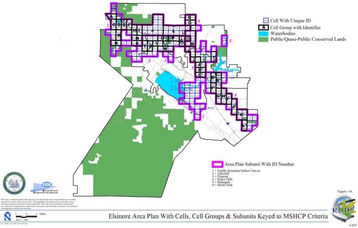
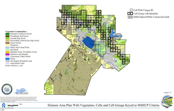
3.3.4 Harvest Valley/Winchester Area Plan
➤ Target Acreages
➤ Applicable Cores and Linkages
➤ Area Plan Subunits
TABLE 3-5
CRITERIA FOR VALLEY/WINCHESTER AREA PLAN
| Sub Unit |
Cell Group | Quadrat Number |
USGS Section | Quarter Section |
Criteria |
|---|---|---|---|---|---|
| SUBUNIT 1 - French Valley to Diamond Valley Lake Connection | |||||
| 1 | 4980 | 15 | SE | Conservation within this Cell will focus on assembly of Proposed Extension of Existing Core 7. Conservation within this Cell will focus on coastal sage scrub, grassland, chaparral, and agricultural land. Areas conserved within this Cell will be connected to grasslands and coastal sage scrub proposed for conservation in Cell Group S in the Southwest Area Plan to the south. Conservation within this Cell will be approximately 90% focusing on the southeastern portion of the Cell. | |
| SUBUNIT 2 - Hemet Vernal Pools West | |||||
| 2 | 3683 | 13 | NW | Conservation within this Cell will focus on assembly of Proposed Noncontiguous Habitat Block 7. Conservation within this Cell will focus on playas and vernal pools and a variety of upland habitat. Areas conserved within this Cell will be connected to wetlands proposed for conservation in Cell #3684 to the east and to uplands and wetlands proposed for conservation in Cell #3791 to the south. Conservation within this Cell will range from 65%-75% focusing on the eastern portion of the Cell. | |
| 2 | 3684 | 13 | NE | Conservation within this Cell will focus on assembly of Proposed Noncontiguous Habitat Block 7. Conservation within this Cell will focus on assembly of playas and vernal pools habitat. Areas conserved within this Cell will be connected to wetlands proposed for conservation in Cell #3683 to the west and in Cell Group D to the south and north in the San Jacinto Area Plan. Conservation within this Cell will range from 10%-20% focusing on the western portion of the Cell. | |
| 2 | 3791 | 13 | SW | Conservation within this Cell will focus on assembly of Proposed Noncontiguous Habitat Block 7. Conservation within this Cell will focus on playas and vernal pools and a variety of upland habitat. Areas conserved within this Cell will be connected to wetlands and uplands proposed for conservation in Cell #3683 to the north, and to wetlands proposed for conservation in Cell #3891 to the south and in Cell Group D to the east in the San Jacinto Area Plan. Conservation within this Cell will range from 55%-65% focusing on the central portion of the Cell. | |
| 2 | 3887 | 23 | NE | Conservation within this Cell will focus on assembly of Proposed Noncontiguous Habitat Block 7. Conservation within this Cell will focus on playas and vernal pools, coastal sage scrub, grassland, and chaparral. Areas conserved within this Cell will be connected to wetlands proposed for conservation to the east, northeast, and southeast in Cells #3891, #3791, and #4007. Conservation within this Cell will range from 45%-55% focusing on the eastern portion of the Cell. | |
| 2 | 3891 | 24 | NW | Conservation within this Cell will focus on assembly of Proposed Noncontiguous Habitat Block 7. Conservation within this Cell will focus on playas and vernal pool habitat. Areas conserved within this Cell will be connected to wetlands proposed for conservation in Cells #3791, #4007, and #3887 to the north, south, and west, and to wetlands proposed for conservation in Cell Group D to the east in the San Jacinto Area Plan. Conservation within this Cell will range from 45%-55% focusing on the western portion of the Cell. | |
| 2 | 4007 | 24 | SW | Conservation within this Cell will focus on assembly of Existing Constrained Linkage B. Conservation within this Cell will focus on playas and vernal pools. Areas conserved within this Cell will be connected to wetlands proposed for conservation to the north and northwest in Cells #3891 and #3887. Conservation within this Cell will range from 10%-20% focusing on the northwestern portion of the Cell. | |
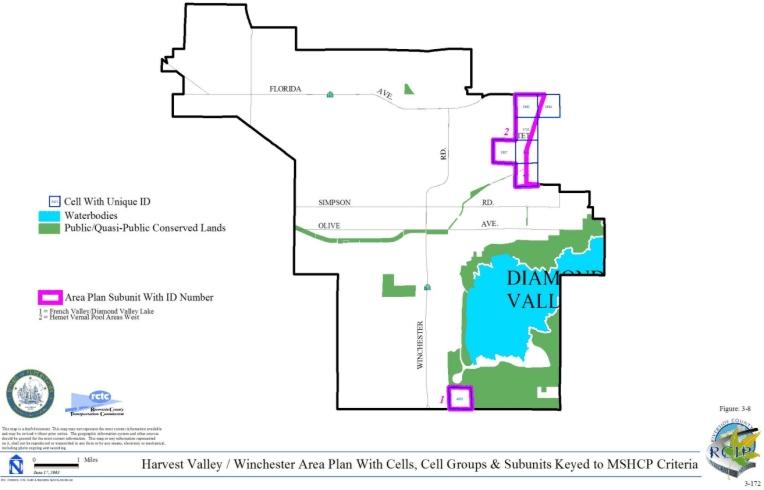
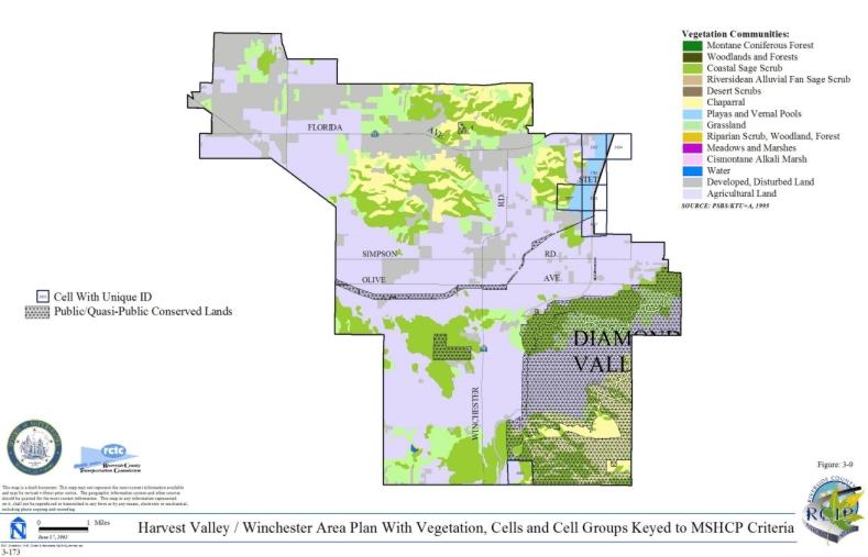
3.3.5 Highgrove Area Plan
➤ Target Acreages
➤ Applicable Cores and Linkages
➤ Area Plan Subunits
TABLE 3-6
CRITERIA FOR HIGHGROVE AREA PLAN
| Sub Unit |
Cell Group | Quadrat Number |
USGS Section | Quarter Section |
Criteria |
|---|---|---|---|---|---|
| SUBUNIT 1 - Sycamore Canyon/Box Springs Central | |||||
| 1 | 545 | 28 | NW | Conservation within this Cell will contribute to assembly of Proposed Constrained Linkage 7. Conservation within this Cell will focus on coastal sage scrub habitat. Areas conserved within this Cell will be connected to coastal sage scub habitat proposed for conservation to the south in Cell #635. Conservation within this Cell will range from 15%-25% of the southeastern portion of the Cell. | |
| 1 | 635 | 28 | SW | Conservation within this Cell will contribute to assembly of Proposed Constrained Linkage 7. Conservation within this Cell will focus on coastal sage scrub habitat. Areas conserved within this Cell will be connected to coastal sage scub habitat proposed for conservation to the south in Cell #721and to the north in Cell #545. Conservation within this Cell will range from 25%-35% of the central portion of the Cell. | |
| 1 | 721 | 33 | NW | Conservation within this Cell will contribute to assembly of Proposed Constrained Linkage 7. Conservation within this Cell will focus on coastal sage scrub habitat and riparian scrub, woodlands and forests. Areas conserved within this Cell will be connected to coastal sage scub habitat proposed for conservation to the north in Cell #635 and to the west in Cell #719 in the City of Riverside. Conservation within this Cell will range from 35%-45% of the northeastern and central portions of the Cell. | |
| SUBUNIT 2 - Springbrook Wash North | |||||
| 2 | 97 | 09 | NE | Conservation within this Cell will contribute to assembly of Proposed Linkage 4. Conservation within this Cell will focus on assembly of coastal sage scrub habitat. Areas conserved within this Cell will be connected to coastal sage scrub habitat proposed for conservation to the east in Cell #101. Conservation within this Cell will range from 40%-50% of the northern portion of the Cell. | |
| 2 | 101 | 10 | NW | Conservation within this Cell will contribute to assembly of Proposed Linkage 4. Conservation within this Cell will focus on coastal sage scrub and annual grasslands habitats. Areas conserved within this Cell will be connected to coastal sage scrub habitat proposed for conservation to the west in Cell #97 and to the east in Cell Group F of the Reche Canyon/Badlands Area Plan, and to annual grasslands proposed for conservation to the south in Cell #148. Conservation within this Cell will range from 65%-75% of the northern and eastern portions of the Cell. | |
| 2 | 146 | 09 | SW | Conservation within this Cell will contribute to assembly of Existing Noncontiguous Habitat Block A. Conservation within this Cell will focus on coastal sage scrub habitat. Areas conserved within this Cell will be connected to coastal sage scrub habitat and annual grasslands proposed for conservation to the south in Cell #196 and to annual grasslands proposed for conservation to the east in Cell #147. Conservation within this Cell will range from 5%-15% of the southern portion of the Cell. | |
| 2 | 147 | 09 | SE | Conservation within this Cell will contribute to assembly of Existing Noncontiguous Habitat Block A. Conservation within this Cell will focus on annual grassland, woodlands and forests habitats. Areas conserved within this Cell will be connected to annual grasslands proposed for conservation to the west in Cell #146 and to annual grasslands, woodlands and forests proposed for conservation to the south in Cell #197. Conservation within this Cell will be approximately 5% of the southwestern portion of the Cell. | |
| 2 | 148 | 10 | SW | Conservation within this Cell will contribute to assembly of Proposed Linkage 4. Conservation within this Cell will focus on annual grasslands habitat. Areas conserved within this Cell will be connected to coastal sage scrub habitat and annual grasslands proposed for conservation to the north in Cell #101 and to Cell Group E in the Reche Canyon/Badlands Area Plan. Conservation within this Cell will range from 5%-15% of the northeastern portion of the Cell. | |
| 2 | 196 | 16 | NW | Conservation within this Cell will contribute to assembly of Existing Noncontiguous Habitat Block A. Conservation within this Cell will focus on coastal sage scrub habitat and annual grasslands. Areas conserved within this Cell will be connected to conserved coastal sage scrub habitat occurring on Box Springs Reserve to the south and to annual grasslands and coastal sage scrub proposed for conservation to the east in Cell #197. Conservation within this Cell will range from 50%-60% of the eastern portion of the Cell. | |
| 2 | 197 | 16 | NE | Conservation within this Cell will contribute to assembly of Existing Noncontiguous Habitat Block A. Conservation within this Cell will focus on coastal sage scrub, annual grasslands, woodlands and forests habitats. Areas conserved within this Cell will be connected to conserved coastal sage scrub habitat occurring on Box Springs Reserve to the south, to annual grasslands and coastal sage scrub proposed for conservation to the west in Cell #196 and to annual grasslands proposed for conservation to the north in Cell #147. Conservation within this Cell will range from 45%-55% of the western portion of the Cell. | |
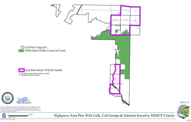
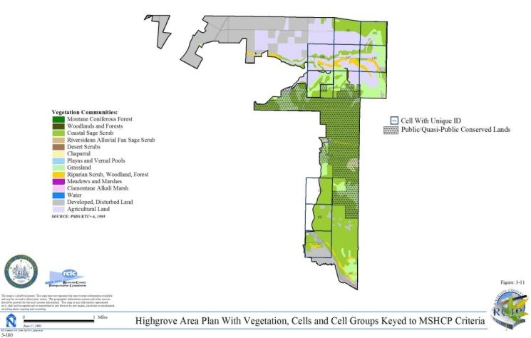
3.3.6 Jurupa Area Plan
➤ Target Acreages
➤ Applicable Cores and Linkages
➤ Area Plan Subunits
TABLE 3-7
CRITERIA FOR JURUPA AREA PLAN
| Sub Unit |
Cell Group | Quadrat Number |
USGS Section | Quarter Section |
Criteria |
|---|---|---|---|---|---|
| SUBUNIT 1 - Santa Ana River North | |||||
| 1 | 187 | 15 | NE | Conservation within this Cell will contribute to assembly of Existing Core A. Conservation within this Cell will focus on Riversidean alluvial fan sage scrub habitat and agricultural land along the Santa Ana River. Conservation within this Cell will range from 15%-25% of the Cell focusing in the eastern portion of the Cell. | |
| 1 | 610 | 29 | SE | Conservation within this Cell will contribute to assembly of Existing Core A. Conservation within this Cell will focus on riparian scrub, woodland, forest and water habitat and agricultural land adjacent to the Santa Ana River. Areas conserved within this Cell will be connected to agricultural land proposed for conservation adjacent to the Santa Ana River in Cell #699 to the southwest and to riparian scrub, woodland, forest and water habitat and agricultural land proposed for conservation along the Santa Ana River in Cell #700 to the south. Conservation within this Cell will range from 30%-40% of the Cell focusing in the southeastern portion of the Cell. | |
| 1 | 617 | 25 | SW | Conservation within this Cell will contribute to assembly of Existing Core A. Conservation within this Cell will focus on lands connecting existing conserved wetland habitat along the Santa Ana River based on existing land constraints. Areas conserved within this Cell will be connected to habitat proposed for conservation in Cell #617 in the Cities of Riverside and Norco to the south. Conservation within this Cell will be approximately 5% of the Cell focusing in the central portion of the Cell. | |
| 1 | 699 | 32 | NW | Conservation within this Cell will contribute to assembly of Existing Core A. Conservation within this Cell will focus on riparian scrub, woodland, forest and water habitat and agricultural land adjacent to the Santa Ana River. Areas conserved within this Cell will be connected to agricultural land proposed for conservation adjacent to the Santa Ana River in Cell #610 to the northeast and in Cell #700 to the east, and to riparian scrub, woodland, forest and water habitat and agricultural land proposed for conservation along the Santa Ana River in Cell #698 in the Eastvale Area Plan to the west and in Cell #699 in the Cities of Riverside and Norco to the south. Conservation within this Cell will range from 25%-35% of the Cell focusing in the northern portion of the Cell. | |
| 1 | 700 | 32 | NE | Conservation within this Cell will contribute to assembly of Existing Core A. Conservation within this Cell will focus on riparian scrub, woodland, forest and water habitat and agricultural land along the Santa Ana River. Areas conserved within this Cell will be connected to agricultural land proposed for conservation adjacent to the Santa Ana River in Cell #699 to the west, to riparian scrub, woodland, forest and water habitat and agricultural land proposed for conservation along the Santa Ana River in Cell #610 to the north, and to riparian scrub, woodland, forest and water habitat proposed for conservation in Cell #700 in the Cities of Riverside and Norco to the south. Conservation within this Cell will range from 25%-35% of the Cell focusing in the northern portion of the Cell. | |
| SUBUNIT 2 - Jurupa Mountains | |||||
| 2 | B | 10 | 03 | NW | Conservation within this Cell Group will contribute to assembly of Proposed Noncontiguous Habitat Block 2. Conservation within this Cell Group will focus on coastal sage scrub and grassland habitat. Areas conserved within this Cell Group will be connected to coastal sage scrub and grassland habitat proposed for conservation in Cell Group C to the east. Conservation within this Cell Group will range from 15%-25% of the Cell Group focusing in the northeastern portion of the Cell Group. See also species-specific conservation objectives 1A, 1B and 1C for Delhi Sands flower-loving fly in Table 9-2 of this document for Criteria for this Cell Group. |
| 2 | B | 12 | 03 | NE | |
| 2 | B | 39 | 03 | SE | |
| 2 | B | 42 | 03 | SW | |
| 2 | C | 14 | 2 | NW | Conservation within this Cell Group will contribute to assembly of Proposed Noncontiguous Habitat Block 2. Conservation within this Cell Group will focus on coastal sage scrub and chaparral habitat. Areas conserved within this Cell Group will be connected to coastal sage scrub and grassland habitat proposed for conservation in Cell Group B to the west and to chaparral and coastal sage scrub habitat proposed for conservation in Cell Group D to the east. Conservation within this Cell Group will range from 35%-45% of the Cell Group focusing in the northern portion of the Cell Group. |
| 2 | C | 40 | 02 | SW | |
| 2 | D | 16 | 2 | NE | Conservation within this Cell Group will contribute to assembly of Proposed Noncontiguous Habitat Block 2. Conservation within this Cell Group will focus on chaparral and coastal sage scrub habitat. Areas conserved within this Cell Group will be connected to coastal sage scrub and chaparral habitat proposed for conservation in Cell Group C to the west. Conservation within this Cell Group will range from 10%-20% of the Cell Group focusing in the northwestern portion of the Cell Group. |
| 2 | D | 44 | 02 | SE | |
| 2 | E | 17 | 01 | NW | Conservation within this Cell Group will contribute to assembly of Proposed Noncontiguous Habitat Block 2. Conservation within this Cell Group will focus on coastal sage scrub habitat. Areas conserved within this Cell Group will be connected to coastal sage scrub habitat proposed for conservation in Cell Group F to the east. Conservation within this Cell Group will range from 5%-15% of the Cell Group focusing in the northeastern portion of the Cell Group. |
| 2 | E | 18 | 01 | NE | |
| 2 | E | 45 | 01 | SW | |
| 2 | E | 46 | 01 | SE | |
| 2 | E | 75 | 12 | NE | |
| 2 | E | 76 | 12 | NW | |
| 2 | F | 15 | 06 | NW | Conservation within this Cell Group will contribute to assembly of Proposed Noncontiguous Habitat Block 2. Conservation within this Cell Group will focus on coastal sage scrub habitat. Areas conserved within this Cell Group will be connected to coastal sage scrub habitat proposed for conservation in Cell Group E to the west and to coastal sage scrub habitat proposed for conservation in Cell Group G to the east. Conservation within this Cell Group will range from 30%-40% of the Cell Group focusing in the northern portion of the Cell Group. |
| 2 | F | 47 | 06 | SW | |
| 2 | F | 78 | 07 | NW | |
| 2 | G | 8 | 05 | NW | Conservation within this Cell Group will contribute to assembly of Proposed Noncontiguous Habitat Block 2. Conservation within this Cell Group will focus on coastal sage scrub habitat. Areas conserved within this Cell Group will be connected to coastal sage scrub habitat proposed for conservation in Cell Group F to the west. Conservation within this Cell Group will range from 10%-20% of the Cell Group focusing in the northwestern portion of the Cell Group. See also species-specific conservation objectives 1A, 1B and 1C for Delhi Sands flower-loving fly in Table 9-2 of this document for Criteria for this Cell Group. |
| 2 | G | 9 | 06 | NE | |
| 2 | G | 11 | 05 | NE | |
| 2 | G | 48 | 06 | SE | |
| 2 | G | 49 | 05 | SW | |
| 2 | G | 50 | 05 | SE | |
| 2 | G | 80 | 07 | NE | |
| SUBUNIT 3 - Delhi Sands Area | |||||
| 3 | A | 68 | 07 | NW | See species-specific conservation objectives 1A, 1B and 1C for Delhi Sands flower-loving fly in Table 9-2 of this document for Criteria for this Cell Group. |
| 3 | A | 118 | 07 | SW | |
| 3 | 21 | 3 | NE | See species-specific conservation objectives 1A, 1B and 1C for Delhi Sands flower-loving fly in Table 9-2 of this document for Criteria for this Cell. | |
| 3 | 22 | 02 | NW | See species-specific conservation objectives 1A, 1B and 1C for Delhi Sands flower-loving fly in Table 9-2 of this document for Criteria for this Cell. | |
| 3 | 35 | 06 | SW | See species-specific conservation objectives 1A, 1B and 1C for Delhi Sands flower-loving fly in Table 9-2 of this document for Criteria for this Cell. | |
| 3 | 55 | 02 | SW | See species-specific conservation objectives 1A, 1B and 1C for Delhi Sands flower-loving fly in Table 9-2 of this document for Criteria for this Cell. | |
| 3 | 168 | 18 | NW | See species-specific conservation objectives 1A, 1B and 1C for Delhi Sands flower-loving fly in Table 9-2 of this document for Criteria for this Cell. | |
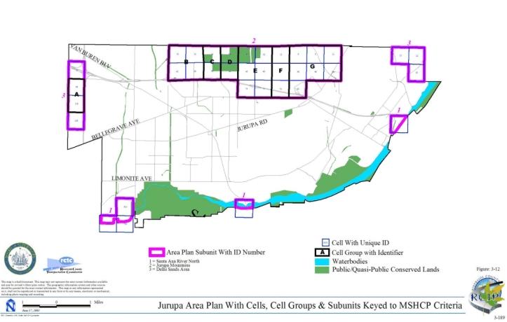
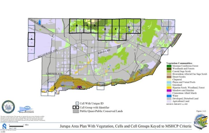
3.3.7 Lake Mathews/Woodcrest Area Plan
➤ Target Acreages
➤ Applicable Cores and Linkages
➤ Area Plan Subunits
TABLE 3-8
CRITERIA FOR MATHEWS/WOODCREST AREA PLAN
| Sub Unit |
Cell Group | Quadrat Number |
USGS Section | Quarter Section |
Criteria |
|---|---|---|---|---|---|
| SUBUNIT 1 - Lake Mathews East | |||||
| 1 | A | 2024 | 02 | NE | Conservation within this Cell Group will contribute to assembly of Proposed Extension of Existing Core 2. Conservation within this Cell Group will focus on coastal sage scrub and grassland habitat. Areas conserved within this Cell Group will be connected to coastal sage scrub and grassland habitat proposed for conservation in Cell Group B to the south. Conservation within this Cell Group will range from 45%-55% of the Cell Group focusing in the western portion of the Cell Group. |
| 1 | A | 2025 | 01 | NW | |
| 1 | B | 2117 | 03 | SE | Conservation within this Cell Group will contribute to assembly of Proposed Extension of Existing Core 2. Conservation within this Cell Group will focus on coastal sage scrub, grassland, riparian scrub, woodland and forest habitat. Areas conserved within this Cell Group will be connected to coastal sage scrub and grassland habitat proposed for conservation in Cell Group A to the north, in Cell #2121 to the east and in Cell #2117 in the Temescal Canyon Area Plan to the west, to coastal sage scrub habitat proposed for conservation in Cell #2407 to the south and in Cell #2308 in the Temescal Canyon Area Plan to the west, and to coastal sage scrub, grassland, riparian scrub, woodland and forest habitat proposed for conservation in Cell #2405 to the south and in Cell #2211 in the Temescal Canyon Area Plan to the west. Conservation within this Cell Group will range from 55%-65% of the Cell Group focusing in the northwestern portion of the Cell Group. |
| 1 | B | 2118 | 02 | SW | |
| 1 | B | 2119 | 02 | SE | |
| 1 | B | 2120 | 01 | SW | |
| 1 | B | 2211 | 10 | NE | |
| 1 | B | 2212 | 11 | NW | |
| 1 | B | 2213 | 11 | NE | |
| 1 | B | 2214 | 12 | NW | |
| 1 | B | 2308 | 10 | SE | |
| 1 | B | 2309 | 11 | SW | |
| 1 | B | 2310 | 11 | SE | |
| 1 | B | 2311 | 12 | SW | |
| 1 | 2026 | 01 | NE | Conservation within this Cell will contribute to assembly of Proposed Extension of Existing Core 2. Conservation within this Cell will focus on coastal sage scrub and grassland habitat adjacent to Lake Mathews. Areas conserved within this Cell will be connected to coastal sage scrub habitat proposed for conservation in Cell Group A to the west and to coastal sage scrub and grassland habitat proposed for conservation in Cell #2121 to the south. Conservation within this Cell will range from 65%-75% of the Cell focusing in the central portion of the Cell. | |
| 1 | 2121 | 01 | SE | Conservation within this Cell will contribute to assembly of Proposed Extension of Existing Core 2. Conservation within this Cell will focus on coastal sage scrub and grassland habitat adjacent to Lake Mathews. Areas conserved within this Cell will be connected to coastal sage scrub and grassland habitat proposed for conservation in Cell Group B to the west and in Cell #2026 to the north. Conservation within this Cell will range from 30%-40% of the Cell focusing in the northern and western portions of the Cell. | |
| 1 | 2405 | 14 | NW | Conservation within this Cell will contribute to assembly of Proposed Extension of Existing Core 2. Conservation within this Cell will focus on coastal sage scrub, grassland, riparian scrub, woodland, and forest habitat. Areas conserved within this Cell will be connected to coastal sage scrub, grassland, riparian scrub, woodland, and forest habitat proposed for conservation in Cell Group B to the north and to coastal sage scrub habitat proposed for conservation in Cell Group C in the Temescal Canyon Area Plan to the west. Conservation within this Cell be approximately 5% of the Cell focusing in the northern portion of the Cell. | |
| 1 | 2407 | 13 | NW | Conservation within this Cell will contribute to assembly of Proposed Extension of Existing Core 2. Conservation within this Cell will focus on coastal sage scrub, grassland, riparian scrub, woodland, and forest habitat. Areas conserved within this Cell will be connected to coastal sage scrub habitat proposed for conservation in Cell Group B to the north and to grassland habitat proposed for conservation in Cell #2408 to the east. Conservation within this Cell will range from 55%-65% of the Cell focusing in the central portion of the Cell. | |
| 1 | 2408 | 13 | NE | Conservation within this Cell will contribute to assembly of Proposed Extension of Existing Core 2. Conservation within this Cell will focus on grassland habitat. Areas conserved within this Cell will be connected to grassland habitat proposed for conservation in Cell #2407 to the west. Conservation within this Cell will range from 5%-15% of the Cell focusing in the central portion of the Cell. | |
| SUBUNIT 2 - Dawson Canyon | |||||
| 2 | C | 2936 | 30 | SW | Conservation within this Cell Group will contribute to assembly of Proposed Extension of Existing Core 2. Conservation within this Cell Group will focus on coastal sage scrub, chaparral, grassland, woodland and forest habitat. Areas conserved within this Cell Group will be connected to coastal sage scrub habitat proposed for conservation in Cell #2935 and in Cell Group G in the Temescal Canyon Area Plan both to the west. Conservation within this Cell Group will range from 75%-85% of the Cell Group focusing in the western portion of the Cell Group. |
| 2 | C | 2938 | 30 | SE | |
| 2 | C | 2941 | 29 | SW | |
| 2 | C | 3040 | 31 | NE | |
| 2 | C | 3145 | 31 | SW | |
| 2 | C | 3146 | 31 | SE | |
| 2 | 2935 | 25 | SE | Conservation within this Cell will contribute to assembly of Proposed Extension of Existing Core 2. Conservation within this Cell will focus on coastal sage scrub, grassland, riparian scrub, woodland, and forest habitat. Areas conserved within this Cell will be connected to coastal sage scrub habitat proposed for conservation in Cell Group C to the east and in Cell #2937 to the west and to coastal sage scrub and grassland habitat proposed for conservation in Cell Group F in the Temescal Canyon Area Plan to the south. Conservation within this Cell will range from 70%-80% of the Cell focusing in the northern and southern portions of the Cell. | |
| 2 | 2937 | 25 | SW | Conservation within this Cell will contribute to assembly of Proposed Extension of Existing Core 2. Conservation within this Cell will focus on coastal sage scrub habitat. Areas conserved within this Cell will be connected to coastal sage scrub habitat proposed for conservation in Cell #2935 to the east and to coastal sage scrub and grassland habitat proposed for conservation in Cell Group F in the Temescal Canyon Area Plan to the south. Conservation within this Cell will range from 10%-20% of the Cell focusing in the southeastern portion of the Cell. | |
| SUBUNIT 3 - Gavilan Hills West | |||||
| 3 | D | 2323 | 12 | SW | Conservation within this Cell Group will contribute to assembly of Proposed Linkage 3. Conservation within this Cell Group will focus on chaparral habitat. Areas conserved within this Cell Group will be connected to riparian scrub, woodland, and forest habitat proposed for conservation in Cell Group H to the south and to habitat proposed for conservation in Cell Group F to the east. Conservation within this Cell Group will be approximately 5% of the Cell Group focusing in the southeastern portion of the Cell Group. |
| 3 | D | 2419 | 13 | NW | |
| 3 | E | 2325 | 07 | SW | Conservation within this Cell Group will contribute to assembly of Proposed Linkage 3. Conservation within this Cell Group will focus on grassland, riparian scrub, woodland, and forest habitat. Areas conserved within this Cell Group will be connected to grassland habitat proposed for conservation in Cell Group G to the south and to grassland, riparian scrub, woodland and forest habitat proposed for conservation in Cell #2324 to the west. Conservation within this Cell Group will range from 10%-20% of the Cell Group focusing in the southwestern portion of the Cell Group. |
| 3 | E | 2326 | 07 | SE | |
| 3 | F | 2420 | 13 | NE | Conservation within this Cell Group will contribute to assembly of Proposed Linkage 3. Conservation within this Cell Group will focus on a mosaic of habitat types including chaparral, coastal sage scrub, grassland, woodland, and forest habitat. Areas conserved within this Cell Group will be connected to grassland and chaparral habitat proposed for conservation in Cell Group G to the east, to chaparral, coastal sage scrub, woodland and forest habitat proposed for conservation in Cell Group I also to the east, to chaparral and coastal sage scrub habitat proposed for conservation in Cell #2629 to the south and in Cell Group H to the west, and to chaparral habitat proposed for conservation in Cell Group D also to the west. Conservation within this Cell Group will range from 75%-85% of the Cell Group focusing in the southern portion of the Cell Group. |
| 3 | F | 2525 | 13 | SE | |
| 3 | G | 2421 | 18 | NW | Conservation within this Cell Group will contribute to assembly of Proposed Linkage 3. Conservation within this Cell Group will focus on a mosaic of habitat types including chaparral, coastal sage scrub, grassland, woodland, and forest habitat. Areas conserved within this Cell Group will be connected to grassland habitat proposed for conservation in Cell Group E to the north, to grassland and chaparral habitat proposed for conservation in Cell Group F to the west, and to grassland, chaparral, and coastal sage scrub habitat proposed for conservation in Cell Group I to the south. Conservation within this Cell Group will range from 20%-30% of the Cell Group focusing in the southwestern portion of the Cell Group. |
| 3 | G | 2422 | 18 | NE | |
| 3 | G | 2423 | 17 | NW | |
| 3 | G | 2428 | 17 | NE | |
| 3 | H | 2523 | 14 | SE | Conservation within this Cell Group will contribute to assembly of Proposed Linkage 3. Conservation within this Cell Group will focus on a mosaic of habitat types including chaparral, coastal sage scrub, riparian scrub, woodland, and forest habitat. Areas conserved within this Cell Group will be connected to chaparral habitat proposed for conservation in Cell Group D to the north, to coastal sage scrub and chaparral habitat proposed for conservation in Cell Group F to the east, and to chaparral, riparian scrub, woodland, and forest habitat proposed for conservation in Cell Group J to the south. Conservation within this Cell Group will range from 30%-40% of the Cell Group focusing in the eastern portion of the Cell Group. |
| 3 | H | 2524 | 13 | SW | |
| 3 | I | 2526 | 18 | SW | Conservation within this Cell Group will contribute to assembly of Proposed Linkage 3. Conservation within this Cell Group will focus on a mosaic of habitat types including chaparral, coastal sage scrub, grassland, woodland, and forest habitat. Areas conserved within this Cell Group will be connected to chaparral, coastal sage scrub, and grassland habitat proposed for conservation in Cell Group G to the north, to coastal sage scrub and chaparral habitat proposed for conservation in Cell Group F to the west and in Cell Group M to the south, and to chaparral, coastal sage scrub, woodland, and forest habitat proposed for conservation in Cell Group L to the south. Conservation within this Cell Group will range from 50%-60% of the Cell Group focusing in the western portion of the Cell Group. |
| 3 | I | 2527 | 18 | SE | |
| 3 | I | 2528 | 17 | SW | |
| 3 | I | 2535 | 17 | SE | |
| 3 | J | 2627 | 23 | NE | Conservation within this Cell Group will contribute to assembly of Proposed Linkage 3. Conservation within this Cell Group will focus on chaparral, riparian scrub, woodland, and forest habitat. Areas conserved within this Cell Group will be connected to chaparral, riparian scrub, woodland and forest habitat proposed for conservation in Cell Group H to the north and to chaparral habitat proposed for conservation in Cell #2629 to the east. Conservation within this Cell Group will be approximately 5% of the Cell Group focusing in the northeastern portion of the Cell Group. |
| 3 | J | 2628 | 24 | NW | |
| 3 | J | 2735 | 23 | SE | |
| 3 | J | 2736 | 24 | SW | |
| 3 | J | 2842 | 26 | NE | |
| 3 | J | 2843 | 25 | NW | |
| 3 | L | 2630 | 19 | NW | Conservation within this Cell Group will contribute to assembly of Proposed Linkage 3. Conservation within this Cell Group will focus on a mosaic of habitat types including chaparral, coastal sage scrub, grassland, woodland, and forest habitat. Areas conserved within this Cell Group will be connected to chaparral, coastal sage scrub, woodland and forest habitat proposed for conservation in Cell Group I to the north, to coastal sage scrub habitat proposed for conservation in Cell #2629 to the west, and to chaparral, grassland, woodland, and forest habitat proposed for conservation in Cell Group M to the east. Conservation within this Cell Group will range from 35%-45% of the Cell Group focusing in the northern portion of the Cell Group. |
| 3 | L | 2738 | 19 | SW | |
| 3 | L | 2846 | 30 | NW | |
| 3 | L | 2951 | 30 | SW | |
| 3 | M | 2631 | 19 | NE | Conservation within this Cell Group will contribute to assembly of Proposed Linkage 3. Conservation within this Cell Group will focus on a mosaic of habitat types including chaparral, coastal sage scrub, grassland, woodland, and forest habitat. Areas conserved within this Cell Group will be connected to chaparral, coastal sage scrub, woodland and forest habitat proposed for conservation in Cell Group I to the north and to chaparral, grassland, woodland, and forest habitat proposed for conservation in Cell Group N to the east and in Cell Group L to the west. Conservation within this Cell Group will range from 30%-40% of the Cell Group focusing in the northern portion of the Cell Group. |
| 3 | M | 2634 | 20 | NW | |
| 3 | M | 2740 | 20 | SW | |
| 3 | M | 2848 | 30 | NE | |
| 3 | M | 2853 | 29 | NW | |
| 3 | M | 2949 | 30 | SE | |
| 3 | M | 2950 | 29 | SW | |
| 3 | N | 2640 | 20 | NE | Conservation within this Cell Group will contribute to assembly of Proposed Linkage 3. Conservation within this Cell Group will focus on a mosaic of habitat types including chaparral, coastal sage scrub, grassland, woodland, and forest habitat. Areas conserved within this Cell Group will be connected to chaparral, grassland, woodland, and forest habitat proposed for conservation in Cell Group M to the west and to coastal sage scrub habitat proposed for conservation in Cell Group C in the Mead Valley Area Plan to the east. Conservation within this Cell Group will range from 40%-50% of the Cell Group focusing in the central portion of the Cell Group. |
| 3 | N | 2745 | 20 | SE | |
| 3 | N | 2858 | 29 | NE | |
| 3 | N | 2954 | 29 | SE | |
| 3 | 2324 | 12 | SE | Conservation within this Cell will contribute to assembly of Proposed Linkage 3. Conservation within this Cell will focus on riparian scrub, woodland, forest and grassland habitat adjacent to the Colorado River Aqueduct. Areas conserved within this Cell will be connected to riparian scrub, woodland, forest and grassland habitat proposed for conservation along the Colorado River Aqueduct in Cell Group E to the east. Conservation within this Cell will range from 25% - 35% of the Cell focusing in the central portion of the Cell. | |
| 3 | 2629 | 24 | NE | Conservation within this Cell will contribute to assembly of Proposed Linkage 3. Conservation within this Cell will focus on coastal sage scrub and chaparral habitat. Areas conserved within this Cell will be connected to chaparral habitat proposed for conservation in Cell Group J to the west, to coastal sage scrub and chaparral habitat proposed for conservation in Cell Group F to the north, and to woodland and forest habitat proposed for conservation in Cell Group L to the east. Conservation within this Cell will range from 5%-15% of the Cell focusing in the northern portion of the Cell. | |
| 3 | K | 2844 | 25 | NE | No new conservation is anticipated within this Cell Group. |
| 3 | K | 2948 | 25 | SE | |
| SUBUNIT 4 - Good Hope West | |||||
| 4 | O | 3051 | 31 | NE | Conservation within this Cell Group will contribute to assembly of Proposed Linkage 3. Conservation within this Cell Group will focus on chaparral and coastal sage scrub habitat. Areas conserved within this Cell Group will be connected to coastal sage scrub habitat proposed for conservation in Cell Group F in the Mead Valley Area Plan to the east. Conservation within this Cell Group will range from 5%-15% of the Cell Group focusing in the central and eastern portions of the Cell Group. |
| 4 | O | 3052 | 32 | NW | |
| 4 | O | 3054 | 32 | NE | |
| 4 | O | 3056 | 31 | NW | |
| 4 | P | 3158 | 32 | SW | Conservation within this Cell Group will contribute to assembly of Proposed Linkage 3. Conservation within this Cell Group will focus on chaparral and coastal sage scrub habitat. Conservation within this Cell Group will range from 10%-20% of the Cell Group focusing in the central portion of the Cell Group. |
| 4 | P | 3161 | 32 | SE | |
| 4 | Q | 3263 | 05 | NW | Conservation within this Cell Group will contribute to assembly of Proposed Linkage 3. Conservation within this Cell Group will focus on chaparral and grassland habitat. Areas conserved within this Cell Group will be connected to chaparral and coastal sage scrub habitat proposed for conservation in Cell Group H in the Mead Valley Area Plan to the northeast. Conservation within this Cell Group will range from 5%-15% of the Cell Group focusing in the northeastern portion of the Cell Group. |
| 4 | Q | 3267 | 05 | NE | |
| 4 | R | 3370 | 05 | SE | Conservation within this Cell Group will contribute to assembly of Proposed Core 1. Conservation within this Cell Group will focus on chaparral, coastal sage scrub, riparian scrub, woodland and forest habitat. Areas conserved within this Cell Group will be connected to chaparral, coastal sage scrub, riparian scrub, woodland and forest habitat proposed for conservation in Cell Group B in the Elsinore Area Plan to the south. Conservation within this Cell Group will range from 10%-20% of the Cell Group focusing in the southeastern portion of the Cell Group. |
| 4 | R | 3372 | 05 | SW | |
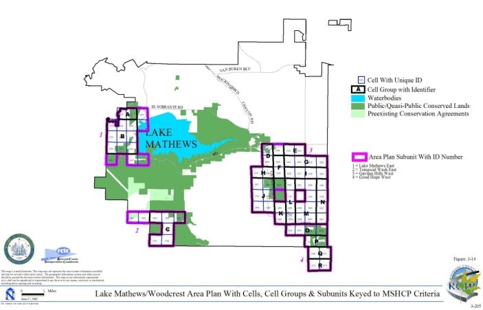
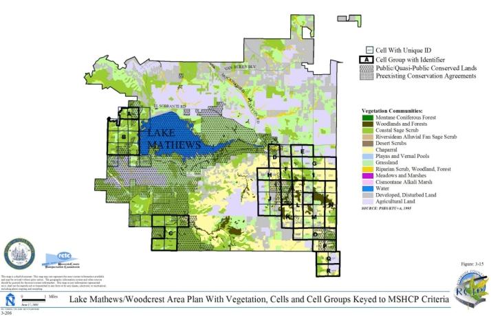
3.3.8 Lakeview/Nuevo Area Plan
➤ Target Acreages
➤ Applicable Cores and Linkages
➤ Area Plan Subunits
| San Jacinto Valley crownscale | 236 acres |
| thread-leaved brodiaea | 24 acres |
| spreading navarretia | 5 acres |
| Davidson's saltscale and Wright's trichochoronis (aggregate) | 0.2 acre |
| Coulter's goldfields | 33 acres |
TABLE 3-9
CRITERIA FOR LAKEVIEW/NUEVO AREA PLAN
| Sub Unit |
Cell Group | Quadrat Number |
USGS Section | Quarter Section |
Criteria |
|---|---|---|---|---|---|
| SUBUNIT 1 - San Jacinto River, Middle Reach | |||||
| 1 |
A |
3175 | 34 | SW | Conservation within this Cell Group will contribute to Proposed Extension of Existing Core 4. Conservation within this Cell Group will focus on assembly of playas/vernal pool habitat and agricultural land associated with the San Jacinto River. Areas conserved within this Cell Group will be connected to playas/vernal pool habitat and agricultural land proposed for conservation in Cell Group B to the north, to agricultural land proposed for conservation in Cell #3278 and #3279 in the Mead Valley Area Plan to the south, and to playas/vernal pool habitat proposed for conservation in Cell #3174 in the Mead Valley Area Plan to the west. Conservation within this Cell Group will range from 60%-70% of the Cell Group focusing in the western portion of the Cell Group. |
| 1 | A | 3176 | 34 | SE | |
| 1 | B | 2970 | 27 | SW | Conservation within this Cell Group will contribute to Proposed Extension of Existing Core 4. Conservation within this Cell Group will focus on assembly of playas/vernal pool and water habitat and agricultural land associated with the San Jacinto River. Areas conserved within this Cell Group will be connected to playas/vernal pool habitat and agricultural land proposed for conservation in Cell Group A to the south, to grassland, playas/vernal pool and water habitat and agricultural land proposed for conservation in Cell Group C and Cell #2867 to the north, and to agricultural land proposed for conservation in Cell Group G in the Mead Valley Area Plan to the west. Conservation within this Cell Group will range from 70%-80% of the Cell Group focusing in the western portion of the Cell Group. |
| 1 | B | 2971 | 27 | SE | |
| 1 | B | 2975 | 26 | SW | |
| 1 | B | 3070 | 34 | NW | |
| 1 | B | 3071 | 34 | NE | |
| 1 | B | 3072 | 35 | NW | |
| 1 | C | 2863 | 26 | NE | Conservation within this Cell Group will contribute to Proposed Extension of Existing Core 4. Conservation within this Cell Group will focus on assembly of a mosaic of habitat types including grassland, playas/vernal pool and water habitat and agricultural land associated with the San Jacinto River. Areas conserved within this Cell Group will be connected to water habitat and agricultural land proposed for conservation in Cell Group B to the south and southwest and to playas/vernal pool habitat and agricultural land proposed for conservation in Cell #2867 to the west and in Cell Group D to the north. Conservation within this Cell Group will range from 55%-65% of the Cell Group focusing in the western portion of the Cell Group. |
| 1 | C | 2865 | 26 | NW | |
| 1 | D | 2761 | 23 | SE | Conservation within this Cell Group will contribute to Proposed Extension of Existing Core 4. Conservation within this Cell Group will focus on assembly of playas/vernal pool, riparian scrub, woodland and forest habitat and agricultural land adjacent to the San Jacinto River. Areas conserved within this Cell Group will be connected to playas/vernal pool habitat and agricultural land proposed for conservation in Cell Group C to the south, to playas/vernal pool habitat proposed for conservation in Cell Group E to the north, and to playas/vernal pool, riparian scrub, woodland and forest habitat and agricultural land proposed for conservation in Cell #2760 to the east. Conservation within this Cell Group will range from 50%-60% of the Cell Group focusing in the eastern portion of the Cell Group. |
| 1 | D | 2762 | 23 | SW | |
| 1 | E | 2651 | 23 | NE | Conservation within this Cell Group will contribute to assembly of Proposed Extension of Existing Core 4. Conservation within this Cell Group will focus on playas/vernal pool habitat and agricultural land adjacent to the San Jacinto River. Areas conserved within this Cell Group will be connected to playas/vernal pool habitat and agricultural land proposed for conservation in Cell Group D to the southwest, in Cell Group F to the north and in Cell #2760 to the south. Conservation within this Cell Group will range from 70%-80% of the Cell Group focusing in the western portion of the Cell Group. |
| 1 | E | 2652 | 24 | NW | |
| 1 | F | 2547 | 14 | SE | Conservation within this Cell Group will contribute to assembly of Proposed Extension of Existing Core 4. Conservation within this Cell Group will focus on playas/vernal pool habitat and agricultural land adjacent to the San Jacinto River. Areas conserved within this Cell Group will be connected to playas/vernal pool habitat and agricultural land proposed for conservation in Cell Group E to the south and in Cell Group G to the north, and to agricultural land proposed for conservation in Cell #2549 to the east. Conservation within this Cell Group will range from 60%-70% of the Cell Group focusing in the eastern portion of the Cell Group. |
| 1 | F | 2548 | 13 | SW | |
| 1 | G | 2442 | 14 | NE | Conservation within this Cell Group will contribute to assembly of Proposed Extension of Existing Core 4. Conservation within this Cell Group will focus on playas/vernal pool habitat adjacent to the San Jacinto River. Areas conserved within this Cell Group will be connected to playas/vernal pool habitat proposed for conservation in Cell Groups F to the south, I to the north and H to the east. Conservation within this Cell Group will range from 50%-60% of the Cell Group focusing in the eastern portion of the Cell Group. |
| 1 | G | 2443 | 13 | NW | |
| 1 | H | 2444 | 13 | NE | Conservation within this Cell Group will contribute to assembly of Proposed Extension of Existing Core 4. Conservation within this Cell Group will focus on playas/vernal pool habitat and agricultural land adjacent to the San Jacinto River. Areas conserved within this Cell Group will be connected to playas/vernal pool habitat proposed for conservation in Cell Groups I to the northwest and G to the west, and to agricultural land proposed for conservation in Cell #2349 to the north and #2549 to the south. Conservation within this Cell Group will range from 55%-65% of the Cell Group focusing in the western portion of the Cell Group. |
| 1 | H | 2445 | 18 | NW | |
| 1 | I | 2347 | 12 | SW | Conservation within this Cell Group will contribute to assembly of Proposed Extension of Existing Core 4. Conservation within this Cell Group will focus on playas/vernal pool and grassland habitat adjacent to the San Jacinto River. Areas conserved within this Cell Group will be connected to grassland and playas/vernal pool habitat proposed for conservation in Cell #2251 to the north and to playas/vernal pool habitat proposed for conservation in Cell Groups G and H to the south and in Cell #2349 to the east. Conservation within this Cell Group will range from 60%-70% of the Cell Group focusing in the eastern portion of the Cell Group. |
| 1 | I | 2348 | 12 | SE | |
| 1 | J | 2067 | 04 | NW | Conservation within this Cell Group will contribute to assembly of Existing Core H. Conservation within this Cell Group will focus on playas/vernal pool habitat adjacent to the San Jacinto River. Areas conserved within this Cell Group will be connected to playas/vernal pool habitat proposed for conservation in Cell #2161 and #2066 to the west, and #2068 to the east. Conservation within this Cell Group will range from 55%-65% of the Cell Group focusing in the northern portion of the Cell Group. |
| 1 | J | 2162 | 04 | SW | |
| 1 | K | 2164 | 03 | SW | Conservation within this Cell Group will contribute to assembly of Proposed Constrained Linkage 20. Conservation within this Cell Group will focus on water, riparian scrub, woodland and forest habitat and agricultural land adjacent to the San Jacinto River. Areas conserved within this Cell Group will be connected to water habitat and agricultural land proposed for conservation in Cell #2070 to the north, to riparian scrub, woodland, and forest habitat and agricultural land proposed for conservation in Cell Group L to the south, and to agricultural land proposed for conservation in Cell #2166 in the San Jacinto Valley Area Plan to the east. Conservation within this Cell Group will range from 25%-35% of the Cell Group focusing in the eastern portion of the Cell Group. |
| 1 | K | 2165 | 03 | SE | |
| 1 | 2066 | 05 | NE | Conservation within this Cell will contribute to assembly of Existing Core H. Conservation within this Cell will focus on playas/vernal pool habitat adjacent to the San Jacinto River. Areas conserved within this Cell will be connected to playas/vernal pool habitat proposed for conservation in Cell #2161 to the south and Cell Group J to the east. Conservation within this Cell will range from 25%-35% of the Cell focusing in the southeastern portion of the Cell. | |
| 1 | 2068 | 04 | NE | Conservation within this Cell will contribute to assembly of Existing Core H. Conservation within this Cell will focus on playas/vernal pool habitat and agricultural land adjacent to the San Jacinto River. Areas conserved within this Cell will be connected to playas/vernal pool habitat proposed for conservation in Cell Group J to the west, to riparian scrub, woodland, and forest habitat proposed for conservation in Cell #2069 to the east, and to playas/vernal pool habitat proposed for conservation in Cell Group Z in the Reche Canyon/Badlands Area Plan to the north. Conservation within this Cell will range from 45%-55% of the Cell focusing in the northwestern portion of the Cell. | |
| 1 | 2069 | 03 | NW | Conservation within this Cell will contribute to assembly of Existing Core H. Conservation within this Cell will focus on wetland habitat associated with the San Jacinto River. Areas conserved within this Cell will be connected to agricultural land proposed for conservation in Cell #2068 to the west and to playas/vernal pool habitat proposed for conservation in Cell Group Z in the Reche Canyon/Badlands Area Plan to the north. Conservation within this Cell will range from 5%-15% of the Cell focusing in the northern portion of the Cell. | |
| 1 | 2070 | 03 | NE | Conservation within this Cell will contribute to assembly of Proposed Constrained Linkage 20. Conservation within this Cell will focus on water habitat and agricultural land adjacent to the San Jacinto River. Areas conserved within this Cell will be connected to water habitat and agricultural land proposed for conservation in Cell Group K to the south, to playas/vernal pool habitat and agricultural land proposed for conservation in Cell #2071 in the San Jacinto Valley Area Plan to the east, and to playas/vernal pool habitat proposed for conservation in Cell #2070 in the Reche Canyon/Badlands Area Plan to the north. Conservation within this Cell will range from 20%-30% of the Cell focusing in the southeastern portion of the Cell. | |
| 1 | 2161 | 05 | SE | Conservation within this Cell will contribute to assembly of Existing Core H. Conservation within this Cell will focus on playas/vernal pool habitat associated with the San Jacinto River. Areas conserved within this Cell will be connected to playas/vernal pool habitat proposed for conservation in Cell #2066 to the north and in Cell Group J to the east. Conservation within this Cell will range from 45%-55% of the Cell focusing in the eastern portion of the Cell. | |
| 1 | 2251 | 12 | NE | Conservation within this Cell will contribute to assembly of Proposed Extension of Existing Core 4. Conservation within this Cell will focus on playas/vernal pool and grassland habitat adjacent to the San Jacinto River. Areas conserved within this Cell will be connected to playas/vernal pool habitat proposed for conservation in Cell Group I to the south and in Cell #2252 to the east and #2349 to the southeast. Conservation within this Cell will range from 35%-45% of the Cell focusing in the southern portion of the Cell. | |
| 1 | 2252 | 07 | NW | Conservation within this Cell will contribute to assembly of Proposed Extension of Existing Core 4. Conservation within this Cell will focus on playas/vernal pool habitat and agricultural land adjacent to the San Jacinto River. Areas conserved within this Cell will be connected to playas/vernal pool habitat proposed for conservation in Cell Group I to the southwest and in Cell #2251 to the west and #2349 to the south and to agricultural land proposed for conservation in Cell #2253 to the east. Conservation within this Cell will range from 40%-50% of the Cell focusing in the southern portion of the Cell. | |
| 1 | 2253 | 07 | NE | Conservation within this Cell will contribute to assembly of Proposed Extension of Existing Core 4. Conservation within this Cell will focus on agricultural land adjacent to the San Jacinto River. Areas conserved within this Cell will be connected to agricultural land proposed for conservation in Cell #2252 to the west and #2349 to the southwest. Conservation within this Cell will range from 10%-20% of the Cell focusing in the southwestern portion of the Cell. | |
| 1 | 2349 | 07 | SW | Conservation within this Cell will contribute to assembly of Proposed Extension of Existing Core 4. Conservation within this Cell will focus on playas/vernal pool habitat and agricultural land adjacent to the San Jacinto River. Areas conserved within this Cell will be connected to playas/vernal pool habitat proposed for conservation in Cell Group I to the east and in Cell #2251 to the northwest and #2252 to the north, and to agricultural land proposed for conservation in Cell Group H to the south. Conservation within this Cell will range from 60%-70% of the Cell focusing in the western portion of the Cell. | |
| 1 | 2549 | 13 | SE | Conservation within this Cell will contribute to assembly of Proposed Extension of Existing Core 4. Conservation within this Cell will focus on agricultural land adjacent to the San Jacinto River. Areas conserved within this Cell will be connected to agricultural land proposed for conservation in Cell Groups H to the north and F to the west and to playas/vernal pool habitat proposed for conservation in Cell Group G to the northwest. Conservation within this Cell will range from 25%-35% of the Cell focusing in the northwestern portion of the Cell. | |
| 1 | 2760 | 24 | SW | Conservation within this Cell will contribute to assembly of Proposed Extension of Existing Core 4. Conservation within this Cell will focus on agricultural land and playas/vernal pool, riparian scrub, woodland, and forest habitat adjacent to the San Jacinto River. Areas conserved within this Cell will be connected to playas/vernal pool habitat and agricultural land proposed for conservation in Cell Group E to the north and to playas/vernal pool, riparian scrub, woodland, and forest habitat and agricultural land proposed for conservation in Cell Group D to the west. Conservation within this Cell will range from 10%-20% of the Cell focusing in the northwestern portion of the Cell. | |
| 1 | 2867 | 27 | NE | Conservation within this Cell will contribute to assembly of Proposed Extension of Existing Core 4. Conservation within this Cell will focus on playas/vernal pool habitat and agricultural land adjacent to the San Jacinto River. Areas conserved within this Cell will be connected to playas/vernal pool habitat and agricultural land proposed for conservation in Cell Groups B to the south, and C to the east. Conservation within this Cell will range from 40%-50% of the Cell focusing in the southeastern portion of the Cell. | |
| SUBUNIT 2 - Lakeview Mountains West | |||||
| 2 | L | 2258 | 10 | NW | Conservation within this Cell Group will contribute to assembly of Proposed Constrained Linkage 20 and Proposed Noncontiguous Habitat Block 5. Conservation within this Cell Group will focus on a mosaic of habitat types including chaparral, coastal sage scrub, grassland, riparian scrub, woodland and forest habitat. Areas conserved within this Cell Group will be connected to chaparral and coastal sage scrub habitat proposed for conservation in Cell #2555, #2767 and Cell Groups N, O, P all to the west and in Cell Groups N and B' in the San Jacinto Valley Area Plan to the east, to riparian scrub, woodland and forest habitat and agricultural land proposed for conservation in Cell Group K to the north and to chaparral habitat proposed for conservation in Cell Group A', Cell #2663 and #2768 in the San Jacinto Valley Area Plan to the east and in Cell #3187 in the San Jacinto Valley Area Plan to the south. Conservation within this Cell Group will range from 65%-75% of the Cell Group. |
| 2 | L | 2259 | 10 | NE | |
| 2 | L | 2355 | 10 | SW | |
| 2 | L | 2356 | 10 | SE | |
| 2 | L | 2357 | 11 | SW | |
| 2 | L | 2451 | 15 | NW | |
| 2 | L | 2452 | 15 | NE | |
| 2 | L | 2453 | 14 | NW | |
| 2 | L | 2556 | 15 | SW | |
| 2 | L | 2557 | 15 | SE | |
| 2 | L | 2558 | 14 | SW | |
| 2 | L | 2660 | 22 | NW | |
| 2 | L | 2661 | 22 | NE | |
| 2 | L | 2662 | 23 | NW | |
| 2 | L | 2663 | 23 | NE | |
| 2 | L | 2768 | 23 | SE | |
| 2 | L | 2771 | 22 | SW | |
| 2 | L | 2772 | 23 | SW | |
| 2 | L | 2773 | 22 | SE | |
| 2 | L | 2873 | 26 | NE | |
| 2 | L | 2876 | 26 | NW | |
| 2 | L | 2883 | 27 | NW | |
| 2 | L | 2983 | 26 | SW | |
| 2 | L | 2989 | 27 | SW | |
| 2 | L | 3084 | 35 | NW | |
| 2 | L | 3093 | 34 | NW | |
| 2 | M | 2658 | 21 | NW | Conservation within this Cell Group will contribute to assembly of Proposed Noncontiguous Habitat Block 5. Conservation within this Cell Group will focus on chaparral and coastal sage scrub habitat. Areas conserved within this Cell Group will be connected to chaparral and coastal sage scrub habitat proposed for conservation in Cell #2554 and #2555 to the north and #2767 to the south, and to chaparral and Riversidean alluvial fan sage scrub habitat proposed for conservation in Cell #2753 to the south. Conservation within this Cell Group will range from 65%-75% of the Cell Group focusing in the eastern portion of the Cell Group. |
| 2 | M | 2659 | 21 | NE | |
| 2 | N | 2845 | 29 | NE | Conservation within this Cell Group will contribute to assembly of Proposed Noncontiguous Habitat Block 5. Conservation within this Cell Group will focus on chaparral, coastal sage scrub, and grassland habitat. Areas conserved within this Cell Group will be connected to chaparral, coastal sage scrub, and grassland habitat proposed for conservation in Cell #2753 and #2767 to the north and Cell Group L to the east, and to chaparral and coastal sage scrub habitat proposed for conservation in Cell Group O to the south. Conservation within this Cell Group will range from 60%-70% of the Cell Group focusing in the eastern portion of the Cell Group. |
| 2 | N | 2879 | 28 | NW | |
| 2 | N | 2880 | 28 | NE | |
| 2 | O | 2965 | 29 | SW | Conservation within this Cell Group will contribute to assembly of Proposed Noncontiguous Habitat Block 5. Conservation within this Cell Group will focus on chaparral, coastal sage scrub, and grassland habitat. Areas conserved within this Cell Group will be connected to chaparral and coastal sage scrub habitat proposed for conservation in Cell Groups N to the north and P to the south and to coastal sage scrub and grassland habitat proposed for conservation in Cell Group L to the east. Conservation within this Cell Group will range from 70%-80% of the Cell Group focusing in the eastern portion of the Cell Group. |
| 2 | O | 2967 | 29 | SE | |
| 2 | O | 2974 | 28 | SW | |
| 2 | O | 2980 | 28 | SE | |
| 2 | P | 3082 | 32 | NE | Conservation within this Cell Group will contribute to assembly of Proposed Noncontiguous Habitat Block 5. Conservation within this Cell Group will focus on chaparral and coastal sage scrub habitat. Areas conserved within this Cell Group will be connected to chaparral and coastal sage scrub habitat proposed for conservation in Cell Group O to the north and in Cell #3078 to the west, to coastal sage scrub habitat proposed for conservation in Cell #3192 to the south, and to chaparral and Riversidean alluvial fan sage scrub proposed for conservation in Cell Group L to the east. Conservation within this Cell Group will range from 60%-70% of the Cell Group focusing in the eastern portion of the Cell Group. |
| 2 | P | 3088 | 33 | NW | |
| 2 | P | 3092 | 33 | NE | |
| 2 | Q | 2849 | 30 | NE | Conservation within this Cell Group will contribute to assembly of Proposed Noncontiguous Habitat Block 5. Conservation within this Cell Group will focus on grassland and coastal sage scrub habitat. Areas conserved within this Cell Group will be connected to chaparral and grassland habitat proposed for conservation in Cell #3078 to the east and to coastal sage scrub habitat proposed for conservation in Cell #3186 also to the east. Conservation within this Cell Group will be approximately 5% of the Cell Group focusing in the eastern portion of the Cell Group. |
| 2 | Q | 2964 | 30 | SE | |
| 2 | Q | 2976 | 30 | SW | |
| 2 | Q | 3074 | 36 | NE | |
| 2 | Q | 3075 | 31 | NW | |
| 2 | Q | 3077 | 31 | NE | |
| 2 | Q | 3183 | 31 | SW | |
| 2 | Q | 3184 | 31 | SE | |
| 2 | 2554 | 16 | SW | Conservation within this Cell will contribute to assembly of Proposed Noncontiguous Habitat Block 5. Conservation within this Cell will focus on coastal sage scrub and chaparral habitat. Areas conserved within this Cell will be connected to coastal sage scrub and chaparral habitat proposed for conservation in Cell #2555 to the east and in Cell Group M to the south and southeast. Conservation within this Cell will range from 40%-50% of the Cell focusing in the eastern portion of the Cell. | |
| 2 | 2555 | 16 | SE | Conservation within this Cell will contribute to assembly of Proposed Noncontiguous Habitat Block 5. Conservation within this Cell will focus on coastal sage scrub and chaparral habitat. Areas conserved within this Cell will be connected to coastal sage scrub and chaparral habitat proposed for conservation in Cell #2554 to the west and in Cell Group M to the south and southwest. Conservation within this Cell will range from 60%-70% of the Cell focusing in the southern portion of the Cell. | |
| 2 | 2753 | 21 | SW | Conservation within this Cell will contribute to assembly of Proposed Noncontiguous Habitat Block 5. Conservation within this Cell will focus on chaparral, coastal sage scrub and Riversidean alluvial fan sage scrub habitat. Areas conserved within this Cell will be connected to chaparral, coastal sage scrub and Riversidean alluvial fan sage scrub habitat proposed for conservation in Cell #2767 to the east and to chaparral habitat proposed for conservation in Cell Group M to the north and northeast and in Cell Group N to the south and southeast. Conservation within this Cell will range from 40%-50% of the Cell focusing in the eastern portion of the Cell. | |
| 2 | 2767 | 21 | SE | Conservation within this Cell will contribute to assembly of Proposed Noncontiguous Habitat Block 5. Conservation within this Cell will focus on chaparral, coastal sage scrub and Riversidean alluvial fan sage scrub habitat. Areas conserved within this Cell will be connected to chaparral, coastal sage scrub and Riversidean alluvial fan sage scrub habitat proposed for conservation in Cell #2753 to the west and Cell Group N to the south and southwest, to chaparral and coastal sage scrub habitat proposed for conservation in Cell Group M to the north and northwest, and to chaparral habitat proposed for conservation in Cell Group L to the east and southeast. Conservation within this Cell will range from 75%-85% of the Cell focusing in the northern portion of the Cell, as well as the western and southern edges of the Cell. | |
| 2 | 3078 | 32 | NW | Conservation within this Cell will contribute to assembly of Proposed Noncontiguous Habitat Block 5. Conservation within this Cell will focus on chaparral, coastal sage scrub and grassland habitat. Areas conserved within this Cell will be connected to grassland and coastal sage scrub habitat proposed for conservation in Cell Group Q to the west and southwest, to chaparral, coastal sage scrub and grassland habitat proposed for conservation in Cell #3186 to the south, and to chaparral and coastal sage scrub habitat proposed for conservation in Cell Groups P to the east and O to the north and northeast. Conservation within this Cell will range from 55%-65% of the Cell focusing in the southern portion of the Cell as well as the northeastern corner of the Cell. | |
| 2 | 3186 | 32 | SW | Conservation within this Cell will contribute to assembly of Proposed Noncontiguous Habitat Block 5. Conservation within this Cell will focus on chaparral, coastal sage scrub and grassland habitat. Areas conserved within this Cell will be connected to coastal sage scrub and grassland habitat proposed for conservation in Cell Group Q to the west and northwest, to chaparral, coastal sage scrub, and grassland habitat proposed for conservation in Cell #3078 to the north, to chaparral and coastal sage scrub habitat proposed for conservation in Cell #3188 to the east, and to coastal sage scrub habitat proposed for conservation in Cell #3295 to the south. Conservation within this Cell will range from 60%-70% of the Cell focusing in the southwestern portion of the Cell. | |
| 2 | 3188 | 32 | SE | Conservation within this Cell will contribute to assembly of Proposed Noncontiguous Habitat Block 5. Conservation within this Cell will focus on chaparral and coastal sage scrub habitat. Areas conserved within this Cell will be connected to coastal sage scrub and grassland habitat proposed for conservation in Cell #3192 to the east, to chaparral and coastal sage scrub habitat proposed for conservation in Cell #3186 to the west, and to coastal sage scrub habitat proposed for conservation in Cell #3292 to the south and #3295 to the southwest. Conservation within this Cell will range from 35%-45% of the Cell focusing in the southeastern half of the Cell. | |
| 2 | 3192 | 33 | SW | Conservation within this Cell will contribute to assembly of Proposed Noncontiguous Habitat Block 5. Conservation within this Cell will focus on coastal sage scrub, chaparral and grassland habitat. Areas conserved within this Cell will be connected to coastal sage scrub habitat proposed for conservation in Cell Group P to the north and to chaparral and coastal sage scrub habitat proposed for conservation in Cell #3188 to the west. Conservation within this Cell will range from 10%-20% of the Cell focusing in the northwestern portion of the Cell. | |
| 2 | 3292 | 05 | NE | Conservation within this Cell will contribute to assembly of Proposed Noncontiguous Habitat Block 5. Conservation within this Cell will focus on coastal sage scrub habitat. Areas conserved within this Cell will be connected to coastal sage scrub habitat proposed for conservation in Cell #3295 to the west and to chaparral and coastal sage scrub habitat proposed for conservation in Cell #3188 to the north. Conservation within this Cell will range from 15%-25% of the Cell focusing in the northwestern portion of the Cell. | |
| 2 | 3295 | 05 | NW | Conservation within this Cell will contribute to assembly of Proposed Noncontiguous Habitat Block 5. Conservation within this Cell will focus on coastal sage scrub and grassland habitat. Areas conserved within this Cell will be connected to coastal sage scrub habitat proposed for conservation in Cell #3292 to the east and to chaparral and coastal sage scrub habitat proposed for conservation in Cell #3186 to the north and #3188 to the northeast. Conservation within this Cell will range from 65%-75% of the Cell focusing in the northern portion of the Cell. | |
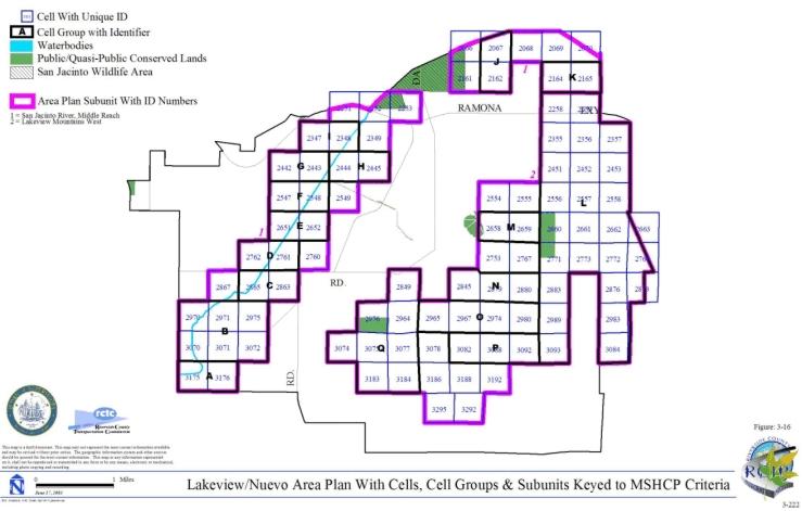
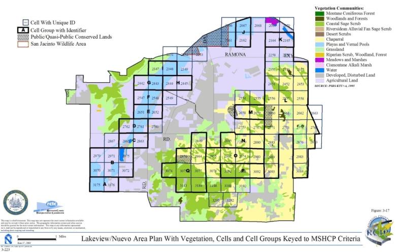
3.3.9 Mead Valley Area Plan
➤ Target Acreages
➤ Applicable Cores and Linkages
➤ Area Plan Subunits
| San Jacinto Valley crownscale | 236 acres |
| thread-leaved brodiaea | 24 acres |
| spreading navarretia | 5 acres |
| Davidson's saltscale and Wright's trichochoronis (aggregate) | 0.2 acre |
| Coulter's goldfields | 33 acres |
TABLE 3-10
CRITERIA FOR MEAD VALLEY AREA PLAN
| Sub Unit |
Cell Group | Quadrat Number |
USGS Section | Quarter Section |
Criteria |
|---|---|---|---|---|---|
| SUBUNIT 1 - Motte/Rimrock | |||||
| 1 | A | 2433 | 14 | NE | Conservation within this Cell Group will contribute to assembly of Proposed Noncontiguous Habitat Block 4. Conservation within this Cell Group will focus on assembly of coastal sage scrub habitat. Areas conserved within this Cell Group will be connected to coastal sage scrub habitat proposed for conservation in Cell #2334 to the north and to coastal sage scrub and grassland habitat proposed for conservation in Cell Group B to the east. Conservation within this Cell Group will range from 50%-60% of the Cell Group focusing in the northern portion of the Cell Group. |
| 1 | A | 2536 | 14 | SE | |
| 1 | B | 2432 | 13 | NW | Conservation within this Cell Group will contribute to assembly of Proposed Noncontiguous Habitat Block 4. Conservation within this Cell Group will focus on assembly of coastal sage scrub and grassland habitat. Areas conserved within this Cell Group will be connected to coastal sage scrub and grassland habitat proposed for conservation in Cell Group A to the west and to coastal sage scrub habitat proposed for conservation in Cell #2529 to the east and #2633 to the south. Conservation within this Cell Group will range from 70%-80% of the Cell Group focusing in the southern portion of the Cell Group. |
| 1 | B | 2533 | 13 | SW | |
| 1 | 2334 | 11 | SE | Conservation within this Cell will contribute to assembly of Proposed Noncontiguous Habitat Block 4. Conservation within this Cell will focus on assembly of coastal sage scrub habitat. Areas conserved within this Cell will be connected to coastal sage scrub habitat proposed for conservation in Cell Group A to the south. Conservation within this Cell will be approximately 5% of the Cell focusing in the southern portion of the Cell. | |
| 1 | 2529 | 13 | SE | Conservation within this Cell will contribute to assembly of Proposed Noncontiguous Habitat Block 4. Conservation within this Cell will focus on assembly of coastal sage scrub habitat. Areas conserved within this Cell will be connected to coastal sage scrub habitat proposed for conservation in Cell Group B to the west. Conservation within this Cell will range from 5%-15% of the Cell focusing in the western portion of the Cell. | |
| 1 | 2633 | 24 | NW | Conservation within this Cell will contribute to assembly of Proposed Noncontiguous Habitat Block 4. Conservation within this Cell will focus on assembly of coastal sage scrub habitat. Areas conserved within this Cell will be connected to coastal sage scrub habitat proposed for conservation in Cell Group B to the north. Conservation within this Cell will range from 10%-20% of the Cell focusing in the northeastern portion of the Cell. | |
| SUBUNIT 2 - Gavilan Hills East | |||||
| 2 | C | 2538 | 16 | SW | Conservation within this Cell Group will contribute to assembly of Proposed Linkage 3. Conservation within this Cell Group will focus on assembly of coastal sage scrub habitat. Areas conserved within this Cell Group will be connected to coastal sage scrub, chaparral, riparian scrub, woodland and forest habitat proposed for conservation in Cell Group F to the south and to chaparral, coastal sage scrub, woodland, and forest habitat proposed for conservation in Cell Group N in the Lake Mathews Area Plan to the west. Conservation within this Cell Group will range from 5%-15% of the Cell Group focusing in the southwestern portion of the Cell Group. |
| 2 | C | 2642 | 21 | NW | |
| 2 | C | 2747 | 21 | SW | |
| 2 | C | 2859 | 28 | NW | |
| 2 | D | 2635 | 21 | NE | Conservation within this Cell Group will contribute to assembly of Proposed Linkage 3. Conservation within this Cell Group will focus on assembly of chaparral, coastal sage scrub, and grassland habitat. Areas conserved within this Cell Group will be connected to coastal sage scrub habitat proposed for conservation in Cell #2956 to the southeast and in Cell Group E to the east. Conservation within this Cell Group will range from 30%-40% of the Cell Group focusing in the southern portion of the Cell Group. |
| 2 | D | 2741 | 21 | SE | |
| 2 | D | 2855 | 28 | NE | |
| 2 | E | 2742 | 22 | SW | Conservation within this Cell Group will contribute to assembly of Proposed Linkage 3. Conservation within this Cell Group will focus on assembly of coastal sage scrub habitat. Areas conserved within this Cell Group will be connected to coastal sage scrub and grassland habitat proposed for conservation in Cell Group D to the west and to coastal sage scrub habitat proposed for conservation in Cell #2956 to the south. Conservation within this Cell Group will be approximately 5% of the Cell Group focusing in the southwestern portion of the Cell Group. |
| 2 | E | 2852 | 27 | NW | |
| 2 | F | 2955 | 28 | SW | Conservation within this Cell Group will contribute to assembly of Proposed Linkage 3. Conservation within this Cell Group will focus on assembly of coastal sage scrub, chaparral, grassland, riparian scrub, woodland, and forest habitat. Areas conserved within this Cell Group will be connected to coastal sage scrub habitat proposed for conservation in Cell Group C to the north and in Cell Group O in the Lake Mathews Area Plan to the west, to coastal sage scrub and grassland habitat proposed for conservation in Cell Group H to the south, and to chaparral and coastal sage scrub habitat proposed for conservation in Cell Group N in the Lake Mathews Area Plan to the west. Conservation within this Cell Group will range from 60%-70% of the Cell Group focusing in the western and central portions of the Cell Group. |
| 2 | F | 3055 | 33 | NW | |
| 2 | H | 3164 | 33 | SW | Conservation within this Cell Group will contribute to assembly of Proposed Linkage 3. Conservation within this Cell Group will focus on assembly of coastal sage scrub, chaparral, and grassland habitat. Areas conserved within this Cell Group will be connected to coastal sage scrub habitat proposed for conservation in Cell Group F to the north and to chaparral habitat proposed for conservation in Cell Group Q in the Lake Mathews Area Plan to the southwest. Conservation within this Cell Group will range from 45%-55% of the Cell Group focusing in the western portion of the Cell Group. |
| 2 | H | 3166 | 33 | SE | |
| 2 | 2956 | 27 | SW | Conservation within this Cell will contribute to assembly of Proposed Linkage 3. Conservation within this Cell will focus on assembly of coastal sage scrub and grassland habitat. Areas conserved within this Cell will be connected to coastal sage scrub and grassland habitat proposed for conservation in Cell #3060 to the south, to coastal sage scrub habitat proposed for conservation in Cell Group E to the north, and to grassland habitat proposed for conservation in Cell Group D to the northwest. Conservation within this Cell will range from 40%-50% of the Cell focusing in the western and southern portions of the Cell. | |
| 2 | 3057 | 34 | NE | Conservation within this Cell will contribute to assembly of Proposed Linkage 3. Conservation within this Cell will focus on assembly of coastal sage scrub and grassland habitat. Areas conserved within this Cell will be connected to coastal sage scrub and grassland habitat proposed for conservation in Cell #3060 to the west and in Cell #2956 to the northwest. Conservation within this Cell will range from 15%-25% of the Cell focusing in the northwestern portion of the Cell. | |
| 2 | 3060 | 34 | NW | Conservation within this Cell will contribute to assembly of Proposed Linkage 3. Conservation within this Cell will focus on assembly of coastal sage scrub and grassland habitat. Areas conserved within this Cell will be connected to coastal sage scrub and grassland habitat proposed for conservation in Cell #3057 to the east and in Cell #2956 to the north. Conservation within this Cell will range from 35%-45% of the Cell focusing in the northeastern portion of the Cell. | |
| SUBUNIT 3 - Good Hope East | |||||
| 3 | I | 3268 | 04 | NE | Conservation within this Cell Group will contribute to assembly of Proposed Linkage 3. Conservation within this Cell Group will focus on assembly of coastal sage scrub, chaparral, and grassland habitat. Conservation within this Cell Group will range from 45%-55% of the Cell Group focusing in the southern portion of the Cell Group. |
| 3 | I | 3366 | 04 | SE | |
| 3 | J | 3564 | 09 | SE | Conservation within this Cell Group will contribute to assembly of Proposed Linkage 3 and of Proposed Core 1. Conservation within this Cell Group will focus on assembly of coastal sage scrub habitat to the west and chaparral habitat to the east. Areas conserved within this Cell Group will be connected to coastal sage scrub habitat proposed for conservation in Cell #3473 to the north, #3667 in the Elsinore Area Plan to the south, and in Cell Group G in the Elsinore Area Plan to the west. Conservation within this Cell Group will range from 55%-65% of the Cell Group focusing in the eastern portion and western edge of the Cell Group. |
| 3 | J | 3569 | 09 | SW | |
| 3 | 3473 | 09 | NW | Conservation within this Cell will contribute to assembly of Proposed Core 1. Conservation within this Cell will focus on assembly of coastal sage scrub habitat. Areas conserved within this Cell will be connected to coastal sage scrub habitat proposed for conservation in Cell Group J to the south and in Cell Group B in the Elsinore Area Plan to the west. Conservation within this Cell will range from 5%-15% of the Cell focusing in the southwestern portion of the Cell. | |
| SUBUNIT 4 - San Jacinto River Lower | |||||
| 4 | G | 2969 | 28 | SE | Conservation within this Cell Group will contribute to assembly of Proposed Extension of Existing Core 4. Conservation within this Cell Group will focus on assembly of agricultural land and playas/vernal pool habitat associated with the San Jacinto River. Areas conserved within this Cell Group will be connected to playas/vernal pool habitat proposed for conservation in Cell #3174 to the south and to playas/vernal pool habitat and agricultural land proposed for conservation in Cell Group B in the Lakeview/Nuevo Area Plan to the east. Conservation within this Cell Group will range from 50%-60% of the Cell Group focusing in the eastern portion of the Cell Group. |
| 4 | G | 3069 | 33 | NE | |
| 4 | K | 3656 | 13 | NW | Conservation within this Cell Group will contribute to assembly of Proposed Linkage 7. Conservation within this Cell Group will focus on assembly of coastal sage scrub, riparian scrub, woodland, forest, grassland and chaparral habitat associated with the San Jacinto River. Areas conserved within this Cell Group will be connected to coastal sage scrub, riparian scrub, woodland, forest, and chaparral habitat proposed for conservation along the San Jacinto River in Cell Group L to the east and to coastal sage scrub, riparian scrub, woodland, and forest habitat proposed for conservation in Cell #3851 in the Elsinore Area Plan to the southwest. Conservation within this Cell Group will range from 45%-55% of the Cell Group focusing in the southern portion of the Cell Group. |
| 4 | K | 3755 | 13 | SW | |
| 4 | L | 3659 | 13 | NE | Conservation within this Cell Group will contribute to assembly of Proposed Linkage 7 and of Proposed Constrained Linkage 19. Conservation within this Cell Group will focus on assembly of riparian scrub, woodland, forest, coastal sage scrub, chaparral and grassland habitat associated with the San Jacinto River. Areas conserved within this Cell Group will be connected to riparian scrub, woodland, forest and coastal sage scrub habitat proposed for conservation along the San Jacinto River in Cell Group K to the west, to riparian scrub, woodland, and forest habitat proposed for conservation along the San Jacinto River in Cell #3570 and #3665 to the northeast, and to chaparral habitat proposed for conservation in Cell #3760 to the east. Conservation within this Cell Group will range from 60%-70% of the Cell Group focusing in the southern and central portions of the Cell Group. |
| 4 | L | 3757 | 13 | SE | |
| 4 | 3173 | 33 | SW | Conservation within this Cell will contribute to assembly of Proposed Constrained Linkage 19. Conservation within this Cell will focus on assembly of grassland habitat associated with the San Jacinto River and west of I-215. Areas conserved within this Cell will be connected along the San Jacinto River to playas/vernal pool habitat proposed for conservation in Cell #3174 to the east and to grassland habitat and agricultural land proposed for conservation in Cell #3277 to the south. Conservation within this Cell will range from 10%-20% of the Cell focusing in the southeastern portion of the Cell. | |
| 4 | 3174 | 33 | SE | Conservation within this Cell will contribute to assembly of Proposed Extension of Existing Core 4. Conservation within this Cell will focus on assembly of playas/vernal pool habitat associated with the San Jacinto River and east of the Perris Valley Storm Drain. Areas conserved within this Cell will be connected to agricultural land proposed for conservation in Cell Group G to the north, Cell #3278 to the south and in Cell #3277 to the southwest, to grassland habitat proposed for conservation in Cell #3173 to the west, and to playas/vernal pool habitat proposed for conservation in Cell Group A in the Lakeview/Nuevo Area Plan to the east. Conservation within this Cell will range from 65%-75% of the Cell focusing in the eastern portion of the Cell. | |
| 4 | 3276 | 05 | NE | Conservation within this Cell will contribute to assembly of Proposed Constrained Linkage 19. Conservation within this Cell will focus on assembly of grassland habitat associated with the San Jacinto River. Areas conserved within this Cell will be connected to grassland habitat and agricultural land proposed for conservation in Cell #3277 to the east and to agricultural land proposed for conservation in Cell #3378 to the south. Conservation within this Cell will range from 45%-55% of the Cell focusing in the southern portion of the Cell. | |
| 4 | 3277 | 04 | NW | Conservation within this Cell will contribute to assembly of Proposed Constrained Linkage 19. Conservation within this Cell will focus on assembly of grassland habitat and agricultural land associated with the San Jacinto River. Areas conserved within this Cell will be connected to grassland habitat proposed for conservation in Cell #3276 to the west and in Cell #3173 to the north, and to agricultural land proposed for conservation in Cell #3174 to the northeast and in Cell #3378 to the southwest. Conservation within this Cell will range from 35%-45% of the Cell focusing in the northwestern portion of the Cell. | |
| 4 | 3278 | 04 | NE | Conservation within this Cell will contribute to assembly of Proposed Extension of Existing Core 4. Conservation within this Cell will focus on assembly of agricultural land associated with the San Jacinto River and east of Highway 74. Areas conserved within this Cell will be connected to playas/vernal pool habitat proposed for conservation in Cell #3174 to the north and in Cell Group A in the Lakeview/Nuevo Area Plan to the northeast and to agricultural land proposed for conservation in Cell #3279 to the east. Conservation within this Cell will range from 45%-55% of the Cell focusing in the northeastern portion of the Cell. | |
| 4 | 3279 | 03 | NW | Conservation within this Cell will contribute to assembly of Proposed Extension of Existing Core 4. Conservation within this Cell will focus on assembly of agricultural land associated with the San Jacinto River. Areas conserved within this Cell will be connected to agricultural land proposed for conservation in Cell #3278 to the west and to playas/vernal pool habitat proposed for conservation in Cell Group A in the Lakeview/Nuevo Area Plan to the north. Conservation within this Cell will range from 30%-40% of the Cell focusing in the western portion of the Cell. | |
| 4 | 3377 | 05 | SW | Conservation within this Cell will contribute to assembly of Proposed Constrained Linkage 19. Conservation within this Cell will focus on assembly of agricultural land associated with the San Jacinto River. Areas conserved within this Cell will be connected to agricultural land proposed for conservation in Cell #3378 to the east and to habitat proposed for conservation in Cell #3467 to the south. Conservation within this Cell will range from 5%-15% of the Cell focusing in the southeastern portion of the Cell. | |
| 4 | 3378 | 05 | SE | Conservation within this Cell will contribute to assembly of Proposed Constrained Linkage 19. Conservation within this Cell will focus on assembly of agricultural land associated with the San Jacinto River. Areas conserved within this Cell will be connected to agricultural land proposed for conservation in Cell #3377 to the west, to grassland habitat proposed for conservation in Cell #3276 to the north, and to agricultural land proposed for conservation in Cell #3277 to the northeast. Conservation within this Cell will range from 30%-40% of the Cell focusing in the northwestern portion of the Cell. | |
| 4 | 3467 | 08 | NW | Conservation within this Cell will contribute to assembly of Proposed Constrained Linkage 19. Conservation within this Cell will focus on assembly of grassland and other habitat contributing to conservation along the San Jacinto River. Areas conserved within this Cell will be connected to agricultural land proposed for conservation in Cell #3377 to the north and #3470 to the west. Conservation within this Cell will be approximately 5% of the Cell focusing in the northwestern portion of the Cell. | |
| 4 | 3470 | 07 | NE | Conservation within this Cell will contribute to assembly of Proposed Constrained Linkage 19. Conservation within this Cell will focus on assembly of agricultural land associated with the San Jacinto River. Areas conserved within this Cell will be connected to grassland and other habitat proposed for conservation in Cell #3467 to the east and to agricultural land proposed for conservation in Cell #3565 to the south. Conservation within this Cell will range from 5%-15% of the Cell focusing in the southeastern portion of the Cell. | |
| 4 | 3565 | 07 | SE | Conservation within this Cell will contribute to assembly of Proposed Constrained Linkage 19. Conservation within this Cell will focus on assembly of agricultural land associated with the San Jacinto River. Areas conserved within this Cell will be connected to agricultural land proposed for conservation in Cell #3570 to the west and in Cell #3470 to the north, and to grassland habitat proposed for conservation in Cell #3467 to the northeast. Conservation within this Cell will range from 20%-30% of the Cell focusing in the northwestern portion of the Cell. | |
| 4 | 3570 | 07 | SW | Conservation within this Cell will contribute to assembly of Proposed Constrained Linkage 19. Conservation within this Cell will focus on assembly of riparian scrub, woodland, forest and coastal sage scrub habitat and agricultural land associated with the San Jacinto River. Areas conserved within this Cell will be connected to agricultural land proposed for conservation in Cell #3565 to the east and to riparian scrub, woodland, forest and grassland habitat proposed for conservation in Cell #3665 to the south. Conservation within this Cell will range from 15%-25% of the Cell focusing in the central portion of the Cell. | |
| 4 | 3665 | 18 | NW | Conservation within this Cell will contribute to assembly of Proposed Constrained Linkage 19 and Proposed Linkage 7. Conservation within this Cell will focus on assembly of riparian scrub, woodland, forest and grassland habitat associated with the San Jacinto River, and also chaparral, coastal sage scrub and grassland habitat in the southern portion of the Cell. Areas conserved within this Cell will be connected to riparian scrub, woodland, forest and coastal sage scrub habitat proposed for conservation in Cell #3570 to the north, to riparian scrub, woodland, forest and grassland habitat proposed for conservation in Cell Group L to the west, and to chaparral, coastal sage scrub, and grassland habitat proposed for conservation in Cell #3760 to the south. Conservation within this Cell will be approximately 5% of the Cell focusing in the northwestern portion and in the southern portion of the Cell. | |
| 4 | 3760 | 18 | SW | Conservation within this Cell will contribute to assembly of Proposed Linkage 7. Conservation within this Cell will focus on assembly of chaparral and coastal sage scrub habitat. Areas conserved within this Cell will be connected to chaparral and coastal sage scrub habitat proposed for conservation in Cell Group L to the west and to chaparral, coastal sage scrub and grassland habitat proposed for conservation in Cell #3665 to the north. Conservation within this Cell will range from 20%-30% of the Cell focusing in the northern portion of the Cell. | |
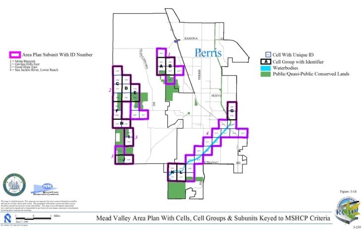
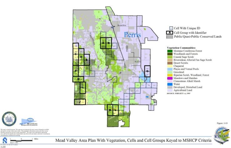
3.3.10 The Pass Area Plan
➤ Target Acreages
➤ Applicable Cores and Linkages
➤ Area Plan Subunits
TABLE 3-11
CRITERIA FOR THE PASS AREA PLAN
| Sub Unit |
Cell Group | Quadrat Number |
USGS Section | Quarter Section |
Criteria | ||||||||||||||||||||||||||||||||||||||||||||||||||||||||||||||||||||
|---|---|---|---|---|---|---|---|---|---|---|---|---|---|---|---|---|---|---|---|---|---|---|---|---|---|---|---|---|---|---|---|---|---|---|---|---|---|---|---|---|---|---|---|---|---|---|---|---|---|---|---|---|---|---|---|---|---|---|---|---|---|---|---|---|---|---|---|---|---|---|---|---|---|
| SUBUNIT 1 - Potrero/Badlands | |||||||||||||||||||||||||||||||||||||||||||||||||||||||||||||||||||||||||
| 1 | A | 1609 | 19 | SW | Conservation within this Cell Group will contribute to assembly of Proposed Core 3 and Existing Core K. Conservation within this Cell Group will focus on chaparral, coastal sage scrub, Riversidean alluvial fan sage scrub and water. Areas conserved within this Cell Group will be connected to uplands and water proposed for conservation in Cell Group B to the west. Conservation within this Cell Group will range from 40%-50% focusing on the northern and southern portions of the Cell Group. | ||||||||||||||||||||||||||||||||||||||||||||||||||||||||||||||||||||
| 1 | A | 1708 | 30 | NE | |||||||||||||||||||||||||||||||||||||||||||||||||||||||||||||||||||||
| 1 | A | 1710 | 30 | NW | |||||||||||||||||||||||||||||||||||||||||||||||||||||||||||||||||||||
| 1 | A | 1799 | 30 | SW | |||||||||||||||||||||||||||||||||||||||||||||||||||||||||||||||||||||
| 1 | A | 1897 | 31 | NW | |||||||||||||||||||||||||||||||||||||||||||||||||||||||||||||||||||||
| 1 | A | 1899 | 31 | NE | |||||||||||||||||||||||||||||||||||||||||||||||||||||||||||||||||||||
| 1 | A | 2000 | 31 | SW | |||||||||||||||||||||||||||||||||||||||||||||||||||||||||||||||||||||
| 1 | A | 2002 | 31 | SE | |||||||||||||||||||||||||||||||||||||||||||||||||||||||||||||||||||||
| 1 | A | 2094 | 06 | NW | |||||||||||||||||||||||||||||||||||||||||||||||||||||||||||||||||||||
| 1 | A | 2181 | 06 | SW | |||||||||||||||||||||||||||||||||||||||||||||||||||||||||||||||||||||
| 1 | B | 1311 | 18 | NW | Conservation within this Cell Group will contribute to assembly of Proposed Core 3. Conservation within this Cell Group will focus on chaparral, coastal sage scrub, Riversidean alluvial fan sage scrub, water, and riparian scrub, woodland, forest. Areas conserved within this Cell Group will be connected to uplands and water proposed for conservation in Cell Group A to the east, in Cell Group P in the San Jacinto Area Plan to the south, and in Cell Groups F and G in the San Jacinto Area Plan to the west, and to uplands proposed for conservation in Cell Groups S, R, O, and Cells #2270 in the San Jacinto Area Plan to the south and in Cell Group M in the San Jacinto Area Plan to the west. Conservation within this Cell Group will range from 45%-55% focusing on the central portions of the Cell Group. | ||||||||||||||||||||||||||||||||||||||||||||||||||||||||||||||||||||
| 1 | B | 1314 | 18 | NE | |||||||||||||||||||||||||||||||||||||||||||||||||||||||||||||||||||||
| 1 | B | 1401 | 18 | SW | |||||||||||||||||||||||||||||||||||||||||||||||||||||||||||||||||||||
| 1 | B | 1403 | 18 | SE | |||||||||||||||||||||||||||||||||||||||||||||||||||||||||||||||||||||
| 1 | B | 1404 | 16 | SE | |||||||||||||||||||||||||||||||||||||||||||||||||||||||||||||||||||||
| 1 | B | 1405 | 15 | SW | |||||||||||||||||||||||||||||||||||||||||||||||||||||||||||||||||||||
| 1 | B | 1410 | 17 | SW | |||||||||||||||||||||||||||||||||||||||||||||||||||||||||||||||||||||
| 1 | B | 1412 | 16 | SW | |||||||||||||||||||||||||||||||||||||||||||||||||||||||||||||||||||||
| 1 | B | 1413 | 17 | SE | |||||||||||||||||||||||||||||||||||||||||||||||||||||||||||||||||||||
| 1 | B | 1499 | 22 | NE | |||||||||||||||||||||||||||||||||||||||||||||||||||||||||||||||||||||
| 1 | B | 1500 | 23 | NW | |||||||||||||||||||||||||||||||||||||||||||||||||||||||||||||||||||||
| 1 | B | 1501 | 23 | NE | |||||||||||||||||||||||||||||||||||||||||||||||||||||||||||||||||||||
| 1 | B | 1502 | 20 | NW | |||||||||||||||||||||||||||||||||||||||||||||||||||||||||||||||||||||
| 1 | B | 1505 | 20 | NE | |||||||||||||||||||||||||||||||||||||||||||||||||||||||||||||||||||||
| 1 | B | 1507 | 21 | NE | |||||||||||||||||||||||||||||||||||||||||||||||||||||||||||||||||||||
| 1 | B | 1508 | 22 | NW | |||||||||||||||||||||||||||||||||||||||||||||||||||||||||||||||||||||
| 1 | B | 1512 | 21 | NW | |||||||||||||||||||||||||||||||||||||||||||||||||||||||||||||||||||||
| 1 | B | 1593 | 22 | SE | |||||||||||||||||||||||||||||||||||||||||||||||||||||||||||||||||||||
| 1 | B | 1594 | 23 | SW | |||||||||||||||||||||||||||||||||||||||||||||||||||||||||||||||||||||
| 1 | B | 1595 | 23 | SE | |||||||||||||||||||||||||||||||||||||||||||||||||||||||||||||||||||||
| 1 | B | 1596 | 24 | S | |||||||||||||||||||||||||||||||||||||||||||||||||||||||||||||||||||||
| 1 | B | 1597 | 22 | SW | |||||||||||||||||||||||||||||||||||||||||||||||||||||||||||||||||||||
| 1 | B | 1599 | 21 | SE | |||||||||||||||||||||||||||||||||||||||||||||||||||||||||||||||||||||
| 1 | B | 1600 | 20 | SE | |||||||||||||||||||||||||||||||||||||||||||||||||||||||||||||||||||||
| 1 | B | 1601 | 21 | SW | |||||||||||||||||||||||||||||||||||||||||||||||||||||||||||||||||||||
| 1 | B | 1689 | 27 | NE | |||||||||||||||||||||||||||||||||||||||||||||||||||||||||||||||||||||
| 1 | B | 1690 | 26 | NW | |||||||||||||||||||||||||||||||||||||||||||||||||||||||||||||||||||||
| 1 | B | 1691 | 25 | N | |||||||||||||||||||||||||||||||||||||||||||||||||||||||||||||||||||||
| 1 | B | 1693 | 26 | NE | |||||||||||||||||||||||||||||||||||||||||||||||||||||||||||||||||||||
| 1 | B | 1694 | 27 | NW | |||||||||||||||||||||||||||||||||||||||||||||||||||||||||||||||||||||
| 1 | B | 1695 | 28 | NE | |||||||||||||||||||||||||||||||||||||||||||||||||||||||||||||||||||||
| 1 | B | 1786 | 27 | SE | |||||||||||||||||||||||||||||||||||||||||||||||||||||||||||||||||||||
| 1 | B | 1787 | 26 | SW | |||||||||||||||||||||||||||||||||||||||||||||||||||||||||||||||||||||
| 1 | B | 1788 | 27 | SW | |||||||||||||||||||||||||||||||||||||||||||||||||||||||||||||||||||||
| 1 | B | 1789 | 26 | SE | |||||||||||||||||||||||||||||||||||||||||||||||||||||||||||||||||||||
| 1 | B | 1792 | 28 | SE | |||||||||||||||||||||||||||||||||||||||||||||||||||||||||||||||||||||
| 1 | B | 1794 | 25 | S | |||||||||||||||||||||||||||||||||||||||||||||||||||||||||||||||||||||
| 1 | B | 1884 | 33 | NW | |||||||||||||||||||||||||||||||||||||||||||||||||||||||||||||||||||||
| 1 | B | 1886 | 33 | NE | |||||||||||||||||||||||||||||||||||||||||||||||||||||||||||||||||||||
| 1 | B | 1887 | 34 | NW | |||||||||||||||||||||||||||||||||||||||||||||||||||||||||||||||||||||
| 1 | B | 1888 | 34 | NE | |||||||||||||||||||||||||||||||||||||||||||||||||||||||||||||||||||||
| 1 | B | 1889 | 35 | NW | |||||||||||||||||||||||||||||||||||||||||||||||||||||||||||||||||||||
| 1 | B | 1890 | 35 | NE | |||||||||||||||||||||||||||||||||||||||||||||||||||||||||||||||||||||
| 1 | B | 1891 | 36 | N | |||||||||||||||||||||||||||||||||||||||||||||||||||||||||||||||||||||
| 1 | B | 1981 | 33 | SW | |||||||||||||||||||||||||||||||||||||||||||||||||||||||||||||||||||||
| 1 | B | 1983 | 33 | SE | |||||||||||||||||||||||||||||||||||||||||||||||||||||||||||||||||||||
| 1 | B | 1986 | 34 | SW | |||||||||||||||||||||||||||||||||||||||||||||||||||||||||||||||||||||
| 1 | B | 1987 | 34 | SE | |||||||||||||||||||||||||||||||||||||||||||||||||||||||||||||||||||||
| 1 | B | 1988 | 35 | SW | |||||||||||||||||||||||||||||||||||||||||||||||||||||||||||||||||||||
| 1 | B | 1989 | 35 | SE | |||||||||||||||||||||||||||||||||||||||||||||||||||||||||||||||||||||
| 1 | B | 1990 | 36 | S | |||||||||||||||||||||||||||||||||||||||||||||||||||||||||||||||||||||
| 1 | B | 2079 | 04 | NW | |||||||||||||||||||||||||||||||||||||||||||||||||||||||||||||||||||||
| 1 | B | 2080 | 04 | NE | |||||||||||||||||||||||||||||||||||||||||||||||||||||||||||||||||||||
| 1 | B | 2081 | 03 | NE | |||||||||||||||||||||||||||||||||||||||||||||||||||||||||||||||||||||
| 1 | B | 2082 | 03 | NW | |||||||||||||||||||||||||||||||||||||||||||||||||||||||||||||||||||||
| 1 | B | 2083 | 02 | NW | |||||||||||||||||||||||||||||||||||||||||||||||||||||||||||||||||||||
| 1 | B | 2084 | 02 | NE | |||||||||||||||||||||||||||||||||||||||||||||||||||||||||||||||||||||
| 1 | B | 2085 | 01 | N | |||||||||||||||||||||||||||||||||||||||||||||||||||||||||||||||||||||
| 1 | B | 2174 | 04 | SW | |||||||||||||||||||||||||||||||||||||||||||||||||||||||||||||||||||||
| 1 | B | 2175 | 04 | SE | |||||||||||||||||||||||||||||||||||||||||||||||||||||||||||||||||||||
| 1 | B | 2176 | 03 | SW | |||||||||||||||||||||||||||||||||||||||||||||||||||||||||||||||||||||
| 1 | B | 2177 | 03 | SE | |||||||||||||||||||||||||||||||||||||||||||||||||||||||||||||||||||||
| 1 | B | 2178 | 02 | SW | |||||||||||||||||||||||||||||||||||||||||||||||||||||||||||||||||||||
| 1 | B | 2179 | 02 | SE | |||||||||||||||||||||||||||||||||||||||||||||||||||||||||||||||||||||
| 1 | B | 2180 | 01 | S | |||||||||||||||||||||||||||||||||||||||||||||||||||||||||||||||||||||
| 1 | B | 2272 | 11 | NW | |||||||||||||||||||||||||||||||||||||||||||||||||||||||||||||||||||||
| 1 | B | 2273 | 11 | NE | |||||||||||||||||||||||||||||||||||||||||||||||||||||||||||||||||||||
| 1 | B | 2369 | 11 | SW | |||||||||||||||||||||||||||||||||||||||||||||||||||||||||||||||||||||
| 1 | B | 2370 | 11 | SE | |||||||||||||||||||||||||||||||||||||||||||||||||||||||||||||||||||||
| 1 | C | 1014 | 06 | SE | Conservation within this Cell Group will contribute to assembly of Proposed Core 3 and Proposed Constrained Linkage 22. Conservation within this Cell Group will focus on coastal sage scrub, chaparral, grassland, and Riversidean alluvial fan sage scrub. Areas conserved within this Cell Group will be connected to uplands proposed for conservation in Cells #937 and #934 to the north and northeast. Conservation within this Cell Group will range from 35%-45% focusing on the western portion of the Cell Group. | ||||||||||||||||||||||||||||||||||||||||||||||||||||||||||||||||||||
| 1 | C | 1024 | 06 | SW | |||||||||||||||||||||||||||||||||||||||||||||||||||||||||||||||||||||
| 1 | 933 | 02 | NW | Conservation within this Cell will contribute to assembly of Proposed Core 3. Conservation within this Cell Group will focus on chaparral, coastal sage scrub, and water. Areas conserved within this Cell Group will be connected to chaparral and wetland habitat proposed for conservation in Cell #936 to the east. Conservation within this Cell Group will range from 20%-30% focusing on the southeastern portion of the cell. | |||||||||||||||||||||||||||||||||||||||||||||||||||||||||||||||||||||
| 1 | 936 | 02 | NE | Conservation within this Cell will contribute to assembly of Proposed Core 3. Conservation within this Cell Group will focus on grassland, chaparral, and coastal sage scrub. Areas conserved within this Cell Group will be connected to uplands proposed for conservation in Cells #933 and #1030 to the west and south. Conservation within this Cell Group will range from 10%-20% focusing on the southwestern portion of the Cell Group. | |||||||||||||||||||||||||||||||||||||||||||||||||||||||||||||||||||||
| 1 | 937 | 06 | NW | Conservation within this Cell will contribute to assembly of Proposed Constrained Linkage 22. Conservation within this Cell will focus on grassland and Riversidean alluvial fan sage scrub. Areas conserved within this Cell will be connected to uplands proposes for conservation in Cell Group C and Cell #934 to the south and east. Conservation within this Cell will range from 40%-50% focusing on the southern portion of the Cell. | |||||||||||||||||||||||||||||||||||||||||||||||||||||||||||||||||||||
| 1 | 1030 | 02 | SE | Conservation within this Cell will contribute to assembly of Proposed Core 3. Conservation within this Cell will focus on chaparral, coastal sage scrub, and grassland. Areas conserved within this Cell will be connected to uplands proposed for conservation in Cells #1032 and #936 to the east and north. Conservation within this Cell will range from 15%-25% focusing on the northeastern portion of the Cell. | |||||||||||||||||||||||||||||||||||||||||||||||||||||||||||||||||||||
| 1 | 1032 | 01 | SW | Conservation within this Cell will contribute to assembly of Proposed Core 3. Conservation within this Cell will focus on chaparral, coastal sage scrub, and grassland. Areas conserved within this Cell will be connected to uplands proposed for conservation in Cells #1030 and #1125 to the west and southeast, and to chaparral and coastal sage scrub habitat proposed for conservation in Cell Group A' in the Reche Canyon/Badlands Area Plan to the south. Conservation within this Cell will range from 45%-55% focusing on the southwestern portion of the Cell. | |||||||||||||||||||||||||||||||||||||||||||||||||||||||||||||||||||||
| 1 | 1125 | 12 | NE | Conservation within this Cell will contribute to assembly of Proposed Core 3. Conservation within this Cell will focus on chaparral and coastal sage scrub. Areas conserved within this Cell will be connected to uplands proposed for conservation in Cell #1032 to the northwest and in Cell Group A' in the Reche Canyon/Badlands Area Plan to the west and south. Conservation within this Cell will range from 15%-25% focusing on the northwestern portion of the Cell. | |||||||||||||||||||||||||||||||||||||||||||||||||||||||||||||||||||||
| SUBUNIT 2 - Badlands/San Bernardino National Forest | |||||||||||||||||||||||||||||||||||||||||||||||||||||||||||||||||||||||||
| 2 | D | 409 | 23 | NW | Conservation within this Cell Group will contribute to assembly of Existing Noncontiguous Habitat Block B. Conservation within this Cell Group will focus on woodlands and forests and chaparral. Conservation within this Cell Group will range from 5%-15% focusing on the northern portion of the Cell Group. | ||||||||||||||||||||||||||||||||||||||||||||||||||||||||||||||||||||
| 2 | D | 497 | 23 | SW | |||||||||||||||||||||||||||||||||||||||||||||||||||||||||||||||||||||
| 2 | 227 | 13 | NE | Conservation within this Cell will contribute to assembly of Existing Core 1. Conservation within this Cell will focus on chaparral and woodlands and forests. Conservation within this Cell will range from 45%-55% focusing on the eastern portion of the Cell. | |||||||||||||||||||||||||||||||||||||||||||||||||||||||||||||||||||||
| 2 | 238 | 15 | NW | Conservation within this Cell will contribute to assembly of Proposed Constrained Linkage 23. Conservation within this Cell will focus on chaparral. Areas conserved within this Cell will be connected to chaparral habitat proposed for conservation to the east and south in Cells #240 and #313. Conservation within this Cell will be approximately 5% focusing on the southeastern portion of the Cell. | |||||||||||||||||||||||||||||||||||||||||||||||||||||||||||||||||||||
| 2 | 240 | 15 | NE | Conservation within this Cell will contribute to assembly of Proposed Constrained Linkage 23. Conservation within this Cell will focus on chaparral. Areas conserved within this Cell will be connected to chaparral habitat proposed for conservation to the west and south in Cells #238 and #324, and to habitat proposed for conservation to the east in Cell #241. Conservation within this Cell will range from 35%-45% focusing on the southern portion of the Cell. | |||||||||||||||||||||||||||||||||||||||||||||||||||||||||||||||||||||
| 2 | 241 | 14 | NW | Conservation within this Cell will contribute to assembly of Proposed Constrained Linkage 23. Conservation within this Cell will focus on chaparral, and woodlands and forests. Areas conserved within this Cell will be connected to chaparral habitat proposed for conservation to the west and east in Cells #240 and #243. Conservation within this Cell will range from 40%-50% focusing on the southern portion of the Cell. | |||||||||||||||||||||||||||||||||||||||||||||||||||||||||||||||||||||
| 2 | 243 | 14 | NE | Conservation within this Cell will contribute to assembly of Proposed Constrained Linkage 23. Conservation within this Cell will focus on chaparral and woodlands and forests. Areas conserved within this Cell will be connected to chaparral habitat proposed for conservation to the west in Cell #241. Conservation within this Cell will range from 30%-40% focusing on the southern portion of the Cell. | |||||||||||||||||||||||||||||||||||||||||||||||||||||||||||||||||||||
| 2 | 311 | 15 | SE | Conservation within this Cell will contribute to assembly of Proposed Constrained Linkage 23. Conservation within this Cell will focus on chaparral and grassland. Areas conserved within this Cell will be connected to chaparral and grassland habitat proposed for conservation to the east and south in Cells #323 and #412. Conservation within this Cell will range from 5%-15% focusing on the southern portion of the Cell. | |||||||||||||||||||||||||||||||||||||||||||||||||||||||||||||||||||||
| 2 | 312 | 16 | SE | Conservation within this Cell will contribute to assembly of Proposed Constrained Linkage 23. Conservation within this Cell will focus on chaparral and woodlands and forest. Areas conserved within this Cell will be connected to chaparral and woodlands and forest proposed for conservation to the east and west in Cells #313 and #329. Conservation within this Cell will range from 30%-40% focusing on the northern portion of the Cell. | |||||||||||||||||||||||||||||||||||||||||||||||||||||||||||||||||||||
| 2 | 313 | 15 | SW | Conservation within this Cell will contribute to assembly of Proposed Constrained Linkage 23. Conservation within this Cell will focus on chaparral and woodlands and forest. Areas conserved within this Cell will be connected to chaparral and woodlands and forest proposed for conservation to the west in Cell #312 and to chaparral habitat proposed for conservation in Cells #324 and #238 to the east and north. Conservation within this Cell will range from 25%-35% focusing on the northern portion of the Cell. | |||||||||||||||||||||||||||||||||||||||||||||||||||||||||||||||||||||
| 2 | 323 | 14 | SW | Conservation within this Cell will contribute to assembly of Proposed Constrained Linkage 23. Conservation within this Cell will focus on chaparral and grassland. Areas conserved within this Cell will be connected to chaparral and grassland habitat proposed for conservation to the south, east, and west in Cells #417, #326, and #311. Conservation within this Cell will range from 5%-15% focusing on the southern portion of the Cell. | |||||||||||||||||||||||||||||||||||||||||||||||||||||||||||||||||||||
| 2 | 324 | 15 | SE | Conservation within this Cell will contribute to assembly of Proposed Constrained Linkage 23. Conservation within this Cell will focus on chaparral. Areas conserved within this Cell will be connected to chaparral habitat proposed for conservation to the west and north in Cells #313 and #240. Conservation within this Cell will range from 5%-15% focusing on the northern portion of the Cell. | |||||||||||||||||||||||||||||||||||||||||||||||||||||||||||||||||||||
| 2 | 326 | 14 | SE | Conservation within this Cell will contribute to assembly of Proposed Constrained Linkage 23. Conservation within this Cell will focus on coastal sage scrub, chaparral, and grassland. Areas conserved within this Cell will be connected to uplands proposed for conservation to the south and west in Cells #411 and #323. Conservation within this Cell will be approximately 5% focusing on the southern portion of the Cell. | |||||||||||||||||||||||||||||||||||||||||||||||||||||||||||||||||||||
| 2 | 329 | 16 | SW | Conservation within this Cell will contribute to assembly of Proposed Constrained Linkage 23. Conservation within this Cell will focus on chaparral and woodlands and forest. Areas conserved within this Cell will be connected to chaparral and woodlands and forest proposed for conservation to the east and south in Cells #312 and #404. Conservation within this Cell will range from 65%-75% focusing on the central and southern portion of the Cell. | |||||||||||||||||||||||||||||||||||||||||||||||||||||||||||||||||||||
| 2 | 396 | 22 | NW | Conservation within this Cell will contribute to assembly of Proposed Constrained Linkage 23. Conservation within this Cell will focus on coastal sage scrub, chaparral, woodlands and forest, grassland, and Riversidean alluvial fan sage scrub. Areas conserved within this Cell will be connected to uplands proposed for conservation to the east and south in Cells #412 and #480. Conservation within this Cell will range from 55%-65% focusing on the central portion of the Cell. | |||||||||||||||||||||||||||||||||||||||||||||||||||||||||||||||||||||
| 2 | 404 | 21 | NW | Conservation within this Cell will contribute to assembly of Proposed Constrained Linkage 23. Conservation within this Cell will focus on chaparral and woodlands and forest. Areas conserved within this Cell will be connected to chaparral and woodlands and forest proposed for conservation to the north and west in Cells #329 and #413. Conservation within this Cell will range from 25%-35% focusing on the northwestern portion of the Cell. | |||||||||||||||||||||||||||||||||||||||||||||||||||||||||||||||||||||
| 2 | 407 | 24 | NE | Conservation within this Cell will contribute to assembly of Proposed Constrained Linkage 23. Conservation within this Cell will focus on chaparral and grassland. Areas conserved within this Cell will be connected to uplands proposed for conservation to the east and west in Cells #411 and #408. Conservation within this Cell will range from 30%-40% focusing on the northern portion of the Cell. | |||||||||||||||||||||||||||||||||||||||||||||||||||||||||||||||||||||
| 2 | 408 | 19 | NW | Conservation within this Cell will contribute to assembly of Proposed Constrained Linkage 23. Conservation within this Cell will focus on chaparral, Riversidean alluvial fan sage scrub, and woodlands and forests. Areas conserved within this Cell will be connected to uplands proposed for conservation to the east and west in Cells #414 and #407. Conservation within this Cell will range from 35%-45% focusing on the northern portion of the Cell. | |||||||||||||||||||||||||||||||||||||||||||||||||||||||||||||||||||||
| 2 | 410 | 24 | NW | Conservation within this Cell will contribute to assembly of Proposed Constrained Linkage 23. Conservation within this Cell will focus on chaparral and grassland. Areas conserved within this Cell will be connected to chaparral habitat proposed for conservation to the east in Cell #407 and to habitat proposed for conservation to the west in Cell #411. Conservation within this Cell will range from 30%-40% focusing on the northern portion of the Cell. | |||||||||||||||||||||||||||||||||||||||||||||||||||||||||||||||||||||
| 2 | 411 | 23 | NE | Conservation within this Cell will contribute to assembly of Proposed Constrained Linkage 23. Conservation within this Cell will focus on grassland and chaparral. Areas conserved within this Cell will be connected to uplands proposed for conservation to the north, and west in Cells #326, and #417, and to habitat proposed for conservation in Cell #410 to the east. Conservation within this Cell will range from 30%-40% focusing on the northern portion of the Cell. | |||||||||||||||||||||||||||||||||||||||||||||||||||||||||||||||||||||
| 2 | 412 | 22 | NE | Conservation within this Cell will contribute to assembly of Proposed Constrained Linkage 23. Conservation within this Cell will focus on grassland, chaparral, woodlands and forest, and coastal sage scrub. Areas conserved within this Cell will be connected to chaparral and grasslands proposed for conservation to the north and east in Cells #311 and #417, and to a variety of uplands proposed for conservation in Cell #396. Conservation within this Cell will range from 35%-45% focusing on the northern portion of the Cell. | |||||||||||||||||||||||||||||||||||||||||||||||||||||||||||||||||||||
| 2 | 413 | 20 | NE | Conservation within this Cell will contribute to assembly of Proposed Constrained Linkage 23. Conservation within this Cell will focus on grassland, chaparral, and woodlands and forest. Areas conserved within this Cell will be connected to chaparral and woodlands and forest proposed for conservation to the east and west in Cells #404 and #416. Conservation within this Cell will range from 80%-90% focusing on the central portion of the Cell. | |||||||||||||||||||||||||||||||||||||||||||||||||||||||||||||||||||||
| 2 | 414 | 19 | NE | Conservation within this Cell will contribute to assembly of Proposed Constrained Linkage 23. Conservation within this Cell will focus on chaparral and woodlands and forest. Areas conserved within this Cell will be connected to chaparral and woodlands and forest proposed for conservation to the east in Cell #416 and a mosaic of upland habitat proposed for conservation to the west in Cell #408. Conservation within this Cell will range from 40%-50% focusing on the central portion of the Cell. | |||||||||||||||||||||||||||||||||||||||||||||||||||||||||||||||||||||
| 2 | 416 | 20 | NW | Conservation within this Cell will contribute to assembly of Proposed Constrained Linkage 23. Conservation within this Cell will focus on chaparral and woodlands and forest. Areas conserved within this Cell will be connected to chaparral and woodlands and forest proposed for conservation to the east and west in Cells #413 and #414. Conservation within this Cell will range from 60%-70% focusing on the central portion of the Cell. | |||||||||||||||||||||||||||||||||||||||||||||||||||||||||||||||||||||
| 2 | 417 | 23 | NW | Conservation within this Cell will contribute to assembly of Proposed Constrained Linkage 23. Conservation within this Cell will focus on chaparral and grassland. Areas conserved within this Cell will be connected to chaparral and woodlands and forest proposed for conservation to the north, east and west in Cells #323, #411 and #412. Conservation within this Cell will range from 25%-35% focusing on the northern portion of the Cell. | |||||||||||||||||||||||||||||||||||||||||||||||||||||||||||||||||||||
| 2 | 479 | 21 | SE | Conservation within this Cell will contribute to assembly of Proposed Constrained Linkage 23. Conservation within this Cell will focus on coastal sage scrub, grassland, chaparral, and a small area of riparian scrub, woodland, forest associated with San Timoteo Creek. Areas conserved within this Cell will be connected to uplands proposed for conservation to the east in Cell #480, and to uplands and wetlands proposed for conservation in Cell Group F to the west. Conservation within this Cell will range from 55%-65% focusing on the eastern and southern portions of the Cell. | |||||||||||||||||||||||||||||||||||||||||||||||||||||||||||||||||||||
| 2 | 480 | 22 | SW | Conservation within this Cell will contribute to assembly of Proposed Constrained Linkage 23. Conservation within this Cell will focus on grassland, chaparral, Riversidean alluvial fan sage scrub, and coastal sage scrub. Areas conserved within this Cell will be connected to uplands proposed for conservation to the north and west in Cells #396 and #479. Conservation within this Cell will range from 20%-30% focusing on the northwestern portion of the Cell. | |||||||||||||||||||||||||||||||||||||||||||||||||||||||||||||||||||||
| 2 | 934 | 06 | NE | Conservation within this Cell will contribute to assembly of Proposed Constrained Linkage 22. Conservation within this Cell will focus on grassland and Riversidean alluvial fan sage scrub. Areas conserved within this Cell will be connected to grassland and Riversidean alluvial fan sage scrub habitat proposed for conservation to the east, west, and southwest in Cells #935, #937, and Cell Group C. Conservation within this Cell will range from 40%-50% focusing on the southern portion of the Cell. | |||||||||||||||||||||||||||||||||||||||||||||||||||||||||||||||||||||
| 2 | 935 | 05 | NW | Conservation within this Cell will contribute to assembly of Proposed Constrained Linkage 22. Conservation within this Cell will focus on grassland, chaparral, and Riversidean alluvial fan sage scrub. Areas conserved within this Cell will be connected to grassland, chaparral and Riversidean alluvial fan sage scrub habitat proposed for conservation to the east and west in Cells #940 and #934. Conservation within this Cell will range from 40%-50% focusing on the southern portion of the Cell. | |||||||||||||||||||||||||||||||||||||||||||||||||||||||||||||||||||||
| 2 | 940 | 05 | NE | Conservation within this Cell will contribute to assembly of Proposed Constrained Linkage 22. Conservation within this Cell will focus on grassland, chaparral, and Riversidean alluvial fan sage scrub. Areas conserved within this Cell will be connected to grassland, chaparral and Riversidean alluvial fan sage scrub habitat proposed for conservation to the west in Cell #935. Conservation within this Cell will range from 30%-40% focusing on the southern portion of the Cell. | |||||||||||||||||||||||||||||||||||||||||||||||||||||||||||||||||||||
| 2 | 1015 | 05 | SW | Conservation within this Cell will contribute to assembly of Proposed Constrained Linkage 22. Conservation within this Cell will focus on chaparral. Areas conserved within this Cell will be connected to chaparral and Riversidean alluvial fan sage scrub habitat proposed for conservation to the north in Cell #935. Conservation within this Cell will be approximately 5% focusing on the northern portion of the Cell. | |||||||||||||||||||||||||||||||||||||||||||||||||||||||||||||||||||||
| SUBUNIT 3 - San Timoteo Creek | |||||||||||||||||||||||||||||||||||||||||||||||||||||||||||||||||||||||||
| 3 | E | 225 | 17 | NW | Conservation within this Cell Group will contribute to assembly of Proposed Linkage 6 and Proposed Linkage 12. Conservation within this Cell Group will focus on riparian scrub, woodland, forest associated with San Timoteo Creek, and coastal sage scrub, grassland, and chaparral. Areas conserved within this Cell will be connected to riparian scrub, woodland, forest and a variety of upland habitat proposed for conservation to the east and west in Cell Groups F and G and to uplands proposed for conservation in Cell Group T in the Reche Canyon/Badlands Area Plan to the south. Conservation within this Cell will range from 75%-85% focusing on the central and southern portions of the Cell Group. | ||||||||||||||||||||||||||||||||||||||||||||||||||||||||||||||||||||
| 3 | E | 233 | 18 | NE | |||||||||||||||||||||||||||||||||||||||||||||||||||||||||||||||||||||
| 3 | E | 301 | 18 | SE | |||||||||||||||||||||||||||||||||||||||||||||||||||||||||||||||||||||
| 3 | E | 302 | 17 | SW | |||||||||||||||||||||||||||||||||||||||||||||||||||||||||||||||||||||
| 3 | E | 383 | 20 | NW | |||||||||||||||||||||||||||||||||||||||||||||||||||||||||||||||||||||
| 3 | E | 387 | 19 | NE | |||||||||||||||||||||||||||||||||||||||||||||||||||||||||||||||||||||
| 3 | E | 475 | 19 | SE | |||||||||||||||||||||||||||||||||||||||||||||||||||||||||||||||||||||
| 3 | E | 476 | 20 | SW | |||||||||||||||||||||||||||||||||||||||||||||||||||||||||||||||||||||
| 3 | F | 384 | 20 | NE | Conservation within this Cell Group will contribute to assembly of Proposed Linkage 12 and Proposed Core 3. Conservation within this Cell Group will focus on riparian scrub, woodland, forest associated with San Timoteo Creek, and coastal sage scrub, grassland, and chaparral. Areas conserved within this Cell will be connected to riparian scrub, woodland, forest and a variety of upland habitat proposed for conservation to the east and west in Cell #567 and Cell Group E, and to wetlands and uplands proposed for conservation in Cell Group T in the Reche Canyon/Badlands Area Plan to the south. Conservation within this Cell will range from 50%-60% focusing on the central and northern portions of the Cell Group. | ||||||||||||||||||||||||||||||||||||||||||||||||||||||||||||||||||||
| 3 | F | 477 | 20 | SE | |||||||||||||||||||||||||||||||||||||||||||||||||||||||||||||||||||||
| 3 | F | 478 | 21 | SW | |||||||||||||||||||||||||||||||||||||||||||||||||||||||||||||||||||||
| 3 | F | 566 | 28 | NW | |||||||||||||||||||||||||||||||||||||||||||||||||||||||||||||||||||||
| 3 | G | 300 | 18 | SW | Conservation within this Cell Group will contribute to assembly of Proposed Linkage 12. Conservation within this Cell Group will focus on riparian scrub, woodland, forest associated with San Timoteo Creek, and coastal sage scrub, grassland, and chaparral. Areas conserved within this Cell Group will be connected to riparian scrub, woodland, forest and a variety of upland habitat proposed for conservation to the east and west in Cell Groups E and H, and to uplands proposed for conservation in Cell Group T in the Reche Canyon/Badlands Area Plan to the south. Conservation within this Cell will range from 50%-60% focusing on the central and southern portions of the Cell Group. | ||||||||||||||||||||||||||||||||||||||||||||||||||||||||||||||||||||
| 3 | G | 388 | 19 | NW | |||||||||||||||||||||||||||||||||||||||||||||||||||||||||||||||||||||
| 3 | H | 299 | 13 | SE | Conservation within this Cell Group will contribute to assembly of Proposed Linkage 12. Conservation within this Cell Group will focus on riparian scrub, woodland, forest associated with San Timoteo Creek, and coastal sage scrub, grassland, and chaparral. Areas conserved within this Cell Group will be connected to riparian scrub, woodland, forest and a variety of upland habitat proposed for conservation to the east in Cell Group G, and in Cells #385 and #298 to the west, and to uplands proposed for conservation in Cell Group T in Reche Canyon/Badlands Area Plan to the south. Conservation within this Cell Group will range from 20%-30% focusing on the southern portions of the Cell Group. | ||||||||||||||||||||||||||||||||||||||||||||||||||||||||||||||||||||
| 3 | H | 386 | 24 | NE | |||||||||||||||||||||||||||||||||||||||||||||||||||||||||||||||||||||
| 3 | 212 | 14 | NW | Conservation within this Cell will contribute to assembly of Proposed Linkage 5. Conservation within this Cell will focus on riparian scrub, woodland, forest associated with San Timoteo Creek, and grassland. Areas conserved within this Cell will be connected to riparian scrub, woodland, forest and a variety of upland habitat proposed for conservation to the east in Cell #213. Conservation within this Cell will range from 10%-20% focusing on the northeast portion of the Cell. | |||||||||||||||||||||||||||||||||||||||||||||||||||||||||||||||||||||
| 3 | 213 | 14 | NE | Conservation within this Cell will contribute to assembly of Proposed Linkage 5. Conservation within this Cell will focus on riparian scrub, woodland, forest associated with San Timoteo Creek, grassland, and Riversidean alluvial fan sage scrub. Areas conserved within this Cell will be connected to riparian scrub, woodland, forest and a variety of upland habitat proposed for conservation to the south and west in Cells #297 and #212. Conservation within this Cell will range from 30%-40% focusing on the western portion of the Cell. | |||||||||||||||||||||||||||||||||||||||||||||||||||||||||||||||||||||
| 3 | 297 | 14 | SE | Conservation within this Cell will contribute to assembly of Proposed Linkage 5. Conservation within this Cell will focus on riparian scrub, woodland, forest associated with San Timoteo Creek, grassland, and Riversidean alluvial fan sage scrub. Areas conserved within this Cell will be connected to riparian scrub, woodland, forest and a variety of upland habitat proposed for conservation to the east and north in Cells #298 and #213, and to chaparral and grassland habitat proposed for conservation in Cell Group T in the Reche Canyon/Badlands Area Plan to the south. Conservation within this Cell will range from 20%-30% focusing on the northeastern portion of the Cell. | |||||||||||||||||||||||||||||||||||||||||||||||||||||||||||||||||||||
| 3 | 298 | 13 | SW | Conservation within this Cell will contribute to assembly of Proposed Linkage 5. Conservation within this Cell will focus on riparian scrub, woodland, forest associated with San Timoteo Creek, and grassland, and chaparral. Areas conserved within this Cell will be connected to riparian scrub, woodland, forest and a variety of upland habitat proposed for conservation to the east, west, and south in Cell Group H and Cells #297 and #385. Conservation within this Cell will range from 55%-65% focusing on the central portion of the Cell. | |||||||||||||||||||||||||||||||||||||||||||||||||||||||||||||||||||||
| 3 | 385 | 24 | NW | Conservation within this Cell will contribute to assembly of Proposed Linkage 5. Conservation within this Cell will focus on riparian scrub, woodland, forest associated with San Timoteo Creek and grassland. Areas conserved within this Cell will be connected to riparian scrub, woodland, forest and grassland habitat proposed for conservation to the east and north in Cell Group H and Cell #298. Conservation within this Cell will be approximately 5% focusing on the northeastern portion of the Cell. | |||||||||||||||||||||||||||||||||||||||||||||||||||||||||||||||||||||
| 3 | 567 | 28 | NE | Conservation within this Cell will contribute to assembly of Proposed Linkage 12. Conservation within this Cell will focus on riparian scrub, woodland, forest associated with San Timoteo Creek, grassland and coastal sage scrub. Areas conserved within this Cell will be connected to riparian scrub, woodland, forest and a mosaic of upland habitat proposed for conservation to the east and north in Cells #569 and #479, and west in Cell Group F. Conservation within this Cell will range from 10%-20% focusing on the northern portion of the Cell. | |||||||||||||||||||||||||||||||||||||||||||||||||||||||||||||||||||||
| 3 | 569 | 27 | NW | Conservation within this Cell will contribute to assembly of Proposed Linkage 12. Conservation within this Cell will focus on riparian scrub, woodland, forest associated with San Timoteo Creek, and grassland. Areas conserved within this Cell will be connected to uplands proposed for conservation to the east and north in Cells #572 and #480 and to riparian habitat proposed for conservation to the west in Cell #567. Conservation within this Cell will range from 30%-40% focusing on the central portion of the Cell. | |||||||||||||||||||||||||||||||||||||||||||||||||||||||||||||||||||||
| 3 | 572 | 27 | NE | Conservation within this Cell will contribute to assembly of Proposed Linkage 12. Conservation within this Cell will focus on grassland. Areas conserved within this Cell will be connected to uplands proposed for conservation to the south and west in Cells #662 and #569. Conservation within this Cell will range from 20%-30% focusing on the southern portion of the Cell. | |||||||||||||||||||||||||||||||||||||||||||||||||||||||||||||||||||||
| 3 | 662 | 27 | SE | Conservation within this Cell will contribute to assembly of Proposed Linkage 12. Conservation within this Cell will focus on grassland, and chaparral. Areas conserved within this Cell will be connected to uplands proposed for conservation to the north and east in Cells #572 and #663. Conservation within this Cell will range from 35%-45% focusing on the northeastern portion of the Cell. | |||||||||||||||||||||||||||||||||||||||||||||||||||||||||||||||||||||
| 3 | 663 | 26 | SW | Conservation within this Cell will contribute to assembly of Proposed Linkage 12. Conservation within this Cell will focus on grassland, coastal sage scrub, and chaparral. Areas conserved within this Cell will be connected to uplands proposed for conservation to the south and west in Cells #753 and #662. Conservation within this Cell will range from 60%-70% focusing on the central portion of the Cell. | |||||||||||||||||||||||||||||||||||||||||||||||||||||||||||||||||||||
| 3 | 753 | 35 | NW | Conservation within this Cell will contribute to assembly of Proposed Linkage 12 and Proposed Core 3. Conservation within this Cell will focus on grassland, coastal sage scrub, and woodlands and forest. Areas conserved within this Cell will be connected to a variety of uplands proposed for conservation to the north in Cell #663. Conservation within this Cell will range from 30%-40% focusing on the northeastern portion of the Cell. | |||||||||||||||||||||||||||||||||||||||||||||||||||||||||||||||||||||
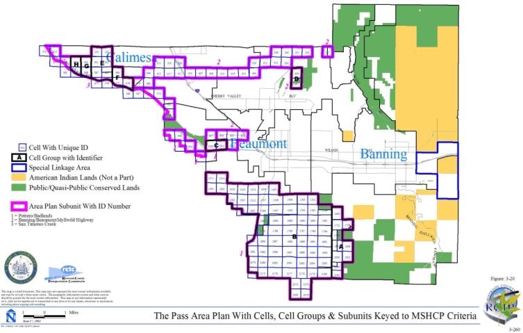
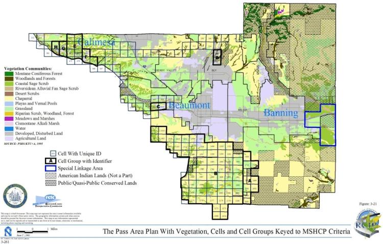
3.3.11 Reche Canyon/Badlands Area Plan
➤ Target Acreages
➤ Applicable Cores and Linkages
➤ Area Plan Subunits
TABLE 3-12
CRITERIA FOR RECHE CANYON/BADLANDS AREA PLAN
| Sub Unit |
Cell Group | Quadrat Number |
USGS Section | Quarter Section |
Criteria |
|---|---|---|---|---|---|
| SUBUNIT 1 - Box Springs East | |||||
| 1 | A | 547 | 27 | NW | Conservation within this Cell Group will contribute to assembly of Proposed Constrained Linkage 8. Conservation within this Cell Group will focus on coastal sage scrub and grassland habitat. Areas conserved within this Cell Group will be connected to coastal sage scrub habitat proposed for conservation in Cell Group B to the east. Conservation within this Cell Group will range from 35%-45% of the Cell Group focusing in the northern portion of the Cell Group. |
| 1 | A | 637 | 27 | SW | |
| 1 | B | 457 | 22 | SE | Conservation within this Cell Group will contribute to assembly of Proposed Constrained Linkage 8. Conservation within this Cell Group will focus on coastal sage scrub and grassland habitat. Areas conserved within this Cell Group will be connected to coastal sage scrub habitat proposed for conservation in Cell Group A to the west. Conservation within this Cell Group will range from 20%-30% of the Cell Group focusing in the central portion of the Cell Group. |
| 1 | B | 548 | 27 | NE | |
| 1 | B | 640 | 27 | SE | |
| SUBUNIT 2 - Reche Canyon | |||||
| 2 | C | 283 | 15 | SE |
Conservation within this Cell Group will contribute to assembly of Proposed Linkage 4. Conservation within this Cell Group will focus on coastal sage scrub and grassland habitat. Areas conserved within this Cell Group will be connected to coastal sage scrub habitat proposed for conservation in Cell #282 to the west and in Cell Groups D to the north and H to the east. Conservation within this Cell Group will range from 45%-55% of the Cell Group focusing in the northwestern portion of the Cell Group. |
| 2 | C | 284 | 14 | SW | |
| 2 | D | 199 | 15 | NE | Conservation within this Cell Group will contribute to assembly of Proposed Linkage 4. Conservation within this Cell Group will focus on chaparral, coastal sage scrub and grassland habitat. Areas conserved within this Cell Group will be connected to chaparral and coastal sage scrub habitat proposed for conservation in Cell Group E to the north and in Cell #201 to the east, and to coastal sage scrub and grassland habitat proposed for conservation in Cell Group C to the south. Conservation within this Cell Group will range from 65%-75% of the Cell Group focusing in the eastern portion of the Cell Group. |
| 2 | D | 200 | 14 | NW | |
| 2 | E | 149 | 10 | SE | Conservation within this Cell Group will contribute to assembly of Proposed Linkage 4. Conservation within this Cell Group will focus on chaparral, coastal sage scrub and grassland habitat. Areas conserved within this Cell Group will be connected to chaparral and coastal sage scrub habitat proposed for conservation in Cell Group D to the south, to chaparral habitat proposed for conservation in Cell Group G to the east, to coastal sage scrub and grassland habitat proposed for conservation in Cell Group F to the north, and to grassland habitat proposed for conservation in Cell #148 in the Highgrove Area Plan to the west. Conservation within this Cell Group will range from 65%-75% of the Cell Group focusing in the eastern half and western edge of the Cell Group. |
| 2 | E | 150 | 11 | SW | |
| 2 | F | 98 | 10 | NE | Conservation within this Cell Group will contribute to assembly of Proposed Linkage 4. Conservation within this Cell Group will focus on coastal sage scrub and grassland habitat. Areas conserved within this Cell Group will be connected to coastal sage scrub and grassland habitat proposed for conservation in Cell Group E to the south, and to coastal sage scrub habitat proposed for conservation in Cell #101 in the Highgrove Area Plan to the west. Conservation within this Cell Group will range from 50%-60% of the Cell Group focusing in the western portion of the Cell Group. |
| 2 | F | 99 | 11 | NW | |
| 2 | G | 100 | 11 | NE | Conservation within this Cell Group will contribute to assembly of Proposed Linkage 4. Conservation within this Cell Group will focus on chaparral habitat. Areas conserved within this Cell Group will be connected to chaparral and coastal sage scrub habitat proposed for conservation in Cell Group E to the west and in Cell #201 to the south. Conservation within this Cell Group will be approximately 5% of the Cell Group focusing in the southwestern portion of the Cell Group. |
| 2 | G | 151 | 11 | SE | |
| 2 | H | 285 | 14 | SE | Conservation within this Cell Group will contribute to assembly of Proposed Linkage 4. Conservation within this Cell Group will focus on chaparral and coastal sage scrub habitat. Areas conserved within this Cell Group will be connected to chaparral and coastal sage scrub habitat proposed for conservation in Cell #201 to the north and in Cell #286 to the east, and to coastal sage scrub habitat proposed for conservation in Cell Group C to the west. Conservation within this Cell Group will range from 20%-30% of the Cell Group focusing in the southern portion of the Cell Group. |
| 2 | H | 369 | 23 | NE | |
| 2 | I | 371 | 24 | NW | Conservation within this Cell Group will contribute to assembly of Proposed Linkage 4. Conservation within this Cell Group will focus on chaparral and coastal sage scrub habitat. Areas conserved within this Cell Group will be connected to chaparral and coastal sage scrub habitat proposed for conservation in Cell #286 to the north and Cell Group L to the east. Conservation within this Cell Group will range from 5%-15% of the Cell Group focusing in the northeastern portion of the Cell Group. |
| 2 | I | 459 | 24 | SW | |
| 2 | J | 152 | 12 | SW | Conservation within this Cell Group will contribute to assembly of Proposed Linkage 4. Conservation within this Cell Group will focus on chaparral habitat. Areas conserved within this Cell Group will be connected to chaparral habitat proposed for conservation in Cell #201 to the west and #286 to the south. Conservation within this Cell Group will be approximately 5% of the Cell Group focusing in the southwestern portion of the Cell Group. |
| 2 | J | 202 | 13 | NW | |
| 2 | K | 153 | 12 | SE | Conservation within this Cell Group will contribute to assembly of Proposed Linkage 4. Conservation within this Cell Group will focus on chaparral habitat. Areas conserved within this Cell Group will be connected to chaparral habitat proposed for conservation in Cell #286 to the west and in Cell Group L to the south. Conservation within this Cell Group will be approximately 5% of the Cell Group focusing in the southwestern portion of the Cell Group. |
| 2 | K | 203 | 13 | NE | |
| 2 | K | 287 | 13 | SE | |
| 2 | L | 372 | 24 | NE | Conservation within this Cell Group will contribute to assembly of Proposed Linkage 4. Conservation within this Cell Group will focus on chaparral and coastal sage scrub habitat. Areas conserved within this Cell Group will be connected to chaparral and coastal sage scrub habitat proposed for conservation in Cell Group I to the west and to chaparral habitat proposed for conservation in Cell Groups K to the north and M to the east. Conservation within this Cell Group will range from 25%-35% of the Cell Group focusing in the northern portion of the Cell Group. |
| 2 | L | 460 | 24 | SE | |
| 2 | L | 551 | 25 | NE | |
| 2 | M | 204 | 18 | NW | Conservation within this Cell Group will contribute to assembly of Proposed Linkage 4. Conservation within this Cell Group will focus on chaparral, coastal sage scrub and grassland habitat. Areas conserved within this Cell Group will be connected to chaparral habitat proposed for conservation in Cell Group L to the west and in Cell Group N to the east. Conservation within this Cell Group will range from 5%-15% of the Cell Group focusing in the central portion of the Cell Group. |
| 2 | M | 288 | 18 | SW | |
| 2 | M | 373 | 19 | NW | |
| 2 | M | 462 | 19 | SW | |
| 2 | M | 553 | 30 | NW | |
| 2 | N | 205 | 18 | NE | Conservation within this Cell Group will contribute to assembly of Proposed Linkage 4. Conservation within this Cell Group will focus on chaparral and coastal sage scrub habitat. Areas conserved within this Cell Group will be connected to chaparral habitat proposed for conservation in Cell Group M to the west and to chaparral and coastal sage scrub habitat proposed for conservation in Cell #381 to the east. Conservation within this Cell Group will range from 5%-15% of the Cell Group focusing in the southern portion of the Cell Group. |
| 2 | N | 289 | 18 | SE | |
| 2 | N | 374 | 19 | NE | |
| 2 | O | 468 | 21 | SW | Conservation within this Cell Group will contribute to assembly of Proposed Linkage 4. Conservation within this Cell Group will focus on chaparral and coastal sage scrub habitat. Areas conserved within this Cell Group will be connected to chaparral habitat proposed for conservation in Cell Group P to the east, to chaparral and coastal sage scrub habitat proposed for conservation in Cell #470 to the west, and to chaparral and grassland habitat proposed for conservation in Cell #379 to the north. Conservation within this Cell Group will range from 5%-15% of the Cell Group focusing in the northern portion of the Cell Group. |
| 2 | O | 561 | 28 | NW | |
| 2 | P | 467 | 21 | SE | Conservation within this Cell Group will contribute to assembly of Proposed Linkage 4. Conservation within this Cell Group will focus on chaparral and coastal sage scrub habitat. Areas conserved within this Cell Group will be connected to chaparral habitat proposed for conservation in Cell Group O to the west and in Cell Group Q to the east, and to chaparral and coastal sage scrub habitat proposed for conservation in Cell #378 to the north. Conservation within this Cell Group will range from 15%-25% of the Cell Group focusing in the northern portion of the Cell Group. |
| 2 | P | 559 | 28 | NE | |
| 2 | 201 | 14 | NE | Conservation within this cell will contribute to assembly of Proposed Linkage 4. Conservation within this cell will focus on chaparral and coastal sage scrub habitat. Areas conserved within this cell will be connected to chaparral habitat proposed for conservation in Cell Groups G to the north and J to the east, and to chaparral and coastal sage scrub habitat proposed for conservation in Cell Groups H to the south and D to the west. Conservation within this cell will range from 70%-80% of the cell focusing in the southwestern portion of the cell. | |
| 2 | 282 | 15 | SW | Conservation within this cell will contribute to assembly of Proposed Linkage 4. Conservation within this cell will focus on coastal sage scrub habitat. Areas conserved within this cell will be connected to coastal sage scrub habitat proposed for conservation in Cell Group C to the east. Conservation within this cell will range from 10%-20% of the cell focusing in the southeastern portion of the cell. | |
| 2 | 286 | 13 | SW | Conservation within this cell will contribute to assembly of Proposed Linkage 4. Conservation within this cell will focus on chaparral and coastal sage scrub habitat. Areas conserved within this cell will be connected to chaparral habitat proposed for conservation in Cell #201 to the northwest and in Cell Groups J to the north, K to the east and L to the southeast, and to chaparral and coastal sage scrub habitat proposed for conservation in Cell Group I to the south and in Cell Group H to the west. Conservation within this cell will range from 60%-70% of the cell focusing in the southwestern portion of the cell. | |
| 2 | 368 | 22 | NE | Conservation within this cell will contribute to assembly of Proposed Linkage 4. Conservation within this cell will focus on a mosaic of upland habitat types including chaparral, coastal sage scrub, and grassland habitat. Areas conserved within this cell will be connected to coastal sage scrub habitat proposed for conservation in Cell Group C to the north. Conservation within this cell will range from 15%-25% of the cell focusing in the northwestern portion of the cell. | |
| 2 | 378 | 21 | NE | Conservation within this cell will contribute to assembly of Proposed Linkage 4. Conservation within this cell will focus on a mosaic of upland habitat types including chaparral, coastal sage scrub, and grassland habitat. Areas conserved within this cell will be connected to grassland habitat proposed for conservation in Cell #379 to the west and to chaparral and coastal sage scrub habitat proposed for conservation in Cell Groups P to the south and Q to the east. Conservation within this cell will range from 55%-65% of the cell focusing in the southern portion of the cell. | |
| 2 | 379 | 21 | NW | Conservation within this cell will contribute to assembly of Proposed Linkage 4. Conservation within this cell will focus on chaparral and grassland habitat. Areas conserved within this cell will be connected to coastal sage scrub and grassland habitat proposed for conservation in Cell #378 to the east, to chaparral and coastal sage scrub habitat proposed for conservation in Cell Group O to the south, and to chaparral habitat proposed for conservation in Cell #380 to the west. Conservation within this cell will range from 30%-40% of the cell focusing in the southern portion of the cell. | |
| 2 | 380 | 20 | NE | Conservation within this cell will contribute to assembly of Proposed Linkage 4. Conservation within this cell will focus on chaparral and coastal sage scrub habitat. Areas conserved within this cell will be connected to chaparral habitat proposed for conservation in Cell #379 to the east and Cell #381 to the west and to chaparral and coastal sage scrub habitat proposed for conservation in Cell #470 to the south. Conservation within this cell will range from 40%-50% of the cell focusing in the southern portion of the cell. | |
| 2 | 381 | 20 | NW | Conservation within this cell will contribute to assembly of Proposed Linkage 4. Conservation within this cell will focus on chaparral and coastal sage scrub habitat. Areas conserved within this cell will be connected to chaparral habitat proposed for conservation in Cell #380 to the east and to chaparral and coastal sage scrub habitat proposed for conservation in Cell #469 to the south and in Cell Group N to the west. Conservation within this cell will range from 45%-55% of the cell focusing in the southern portion of the cell. | |
| 2 | 469 | 20 | SW | Conservation within this cell will contribute to assembly of Proposed Linkage 4. Conservation within this cell will focus on a mosaic of upland habitat types including chaparral, coastal sage scrub and grassland habitat. Areas conserved within this cell will be connected to chaparral and coastal sage scrub habitat proposed for conservation in Cell #381 to the north and to grassland habitat proposed for conservation in Cell #470 to the east. Conservation within this cell will range from 10%-20% of the cell focusing in the northern portion of the cell. | |
| 2 | 470 | 20 | SE | Conservation within this cell will contribute to assembly of Proposed Linkage 4. Conservation within this cell will focus on a mosaic of upland habitat types including chaparral, coastal sage scrub and grassland habitat. Areas conserved within this cell will be connected to chaparral and grassland habitat proposed for conservation in Cell #469 to the west, to chaparral and coastal sage scrub habitat proposed for conservation in Cell #380 to the north, and to coastal sage scrub habitat proposed for conservation in Cell Group O to the east. Conservation within this cell will range from 30%-40% of the cell focusing in the northern portion of the cell. | |
| SUBUNIT 3 - Badlands North | |||||
| 3 | A' | 1125 | 12 | NE | Conservation within this Cell Group will contribute to assembly of Proposed Core 3. Conservation within this Cell Group will focus on chaparral, coastal sage scrub, and grassland habitat. Areas conserved within this Cell Group will be connected to chaparral and coastal sage scrub habitat proposed for conservation in Cell Groups Y to the west and B' to the south and in Cell #1125 in the Pass Area Plan to the north and to chaparral, coastal sage scrub, and grassland habitat proposed for conservation in Cell #1032 in the Pass Area Plan also to the north. Conservation within this Cell Group will range from 55%-65% of the Cell Group focusing in the western portion of the Cell Group. |
| 3 | A' | 1126 | 12 | NW | |
| 3 | B' | 1215 | 10 | SE | Conservation within this Cell Group will contribute to assembly of Proposed Core 3. Conservation within this Cell Group will focus on chaparral, coastal sage scrub, grassland, riparian scrub, woodland, and forest habitat. Areas conserved within this Cell Group will be connected to chaparral, coastal sage scrub, and grassland habitat proposed for conservation in Cell Groups Y and A' both to the north and to chaparral, coastal sage scrub, grassland, riparian scrub, woodland, and forest habitat proposed for conservation in Cell Group C' to the south. Conservation within this Cell Group will range from 70%-80% of the Cell Group focusing in the central portion of the Cell Group. |
| 3 | B' | 1216 | 11 | SW | |
| 3 | B' | 1219 | 11 | SE | |
| 3 | B' | 1222 | 12 | SW | |
| 3 | C' | 1304 | 15 | NE | Conservation within this Cell Group will contribute to assembly of Proposed Core 3. Conservation within this Cell Group will focus on chaparral, coastal sage scrub, grassland, riparian scrub, woodland, and forest habitat. Areas conserved within this Cell Group will be connected to chaparral and coastal sage scrub habitat proposed for conservation in Cell Group X to the west, to chaparral, coastal sage scrub, grassland, and Riversidean alluvial fan sage scrub habitat proposed for conservation in Cell Group E' to the south, and to chaparral, coastal sage scrub, grassland, riparian scrub, woodland, and forest habitat proposed for conservation in Cell Group B' to the north. Conservation within this Cell Group will range from 55%-65% of the Cell Group focusing in the western portion of the Cell Group. |
| 3 | C' | 1305 | 14 | NW | |
| 3 | C' | 1306 | 15 | NW | |
| 3 | C' | 1310 | 13 | NE | |
| 3 | C' | 1312 | 14 | NE | |
| 3 | C' | 1315 | 13 | NW | |
| 3 | E' | 1390 | 16 | SE | Conservation within this Cell Group will contribute to assembly of Proposed Core 3. Conservation within this Cell Group will focus on chaparral, coastal sage scrub, grassland, and Riversidean alluvial fan sage scrub habitat. Areas conserved within this Cell Group will be connected to chaparral, coastal sage scrub and grassland habitat proposed for conservation in Cell Group X to the north, to chaparral, coastal sage scrub, grassland, riparian scrub, woodland, and forest habitat proposed for conservation in Cell Group C' also to the north, and to chaparral, coastal sage scrub, grassland, Riversidean alluvial fan sage scrub habitat proposed for conservation in Cell Group F' to the south. Conservation within this Cell Group will range from 45%-55% of the Cell Group focusing in the western portion of the Cell Group. |
| 3 | E' | 1392 | 15 | SW | |
| 3 | E' | 1393 | 15 | SE | |
| 3 | E' | 1396 | 14 | SW | |
| 3 | E' | 1399 | 14 | SE | |
| 3 | E' | 1400 | 13 | SE | |
| 3 | E' | 1402 | 13 | SW | |
| 3 | F' | 1478 | 22 | NW | Conservation within this Cell Group will contribute to assembly of Proposed Core 3. Conservation within this Cell Group will focus on chaparral, coastal sage scrub, grassland, and Riversidean alluvial fan sage scrub habitat. Areas conserved within this Cell Group will be connected to chaparral, coastal sage scrub, grassland, and Riversidean alluvial fan sage scrub habitat proposed for conservation in Cell Group E' to the north, to chaparral, coastal sage scrub, and Riversidean alluvial fan sage scrub habitat proposed for conservation in Cell Group G' to the south, and to chaparral and coastal sage scrub habitat proposed for conservation in Cell Group A in the San Jacinto Valley Area Plan to the east. Conservation within this Cell Group will range from 65%-75% of the Cell Group focusing in the central portion of the Cell Group. |
| 3 | F' | 1485 | 22 | NE | |
| 3 | F' | 1492 | 23 | NW | |
| 3 | F' | 1494 | 23 | NE | |
| 3 | G' | 1584 | 22 | SE | Conservation within this Cell Group will contribute to assembly of Proposed Core 3. Conservation within this Cell Group will focus on chaparral, coastal sage scrub, riparian scrub, woodland, forest and Riversidean alluvial fan sage scrub habitat. Areas conserved within this Cell Group will be connected to chaparral, coastal sage scrub, and Riversidean alluvial fan sage scrub habitat proposed for conservation in Cell Group F' to the north, to chaparral, coastal sage scrub, riparian scrub, woodland and forest habitat proposed for conservation in Cell Group H' to the south, and to chaparral and coastal sage scrub habitat proposed for conservation in Cell Group A in the San Jacinto Valley Area Plan to the east. Conservation within this Cell Group will range from 75%-85% of the Cell Group focusing in the eastern portion of the Cell Group. |
| 3 | G' | 1587 | 23 | SW | |
| 3 | G' | 1588 | 23 | SE | |
| 3 | H' | 1652 | 26 | NE | Conservation within this Cell Group will contribute to assembly of Proposed Core 3. Conservation within this Cell Group will focus on chaparral, coastal sage scrub, grassland, riparian scrub, woodland, and forest habitat. Areas conserved within this Cell Group will be connected to chaparral, coastal sage scrub, riparian scrub, woodland and forest habitat proposed for conservation in Cell Group G' to the north, to coastal sage scrub habitat proposed for conservation in Cell #1762 to the south, and to chaparral and coastal sage scrub habitat proposed for conservation in Cell Group A in the San Jacinto Valley Area Plan to the east. Conservation within this Cell Group will range from 55%-65% of the Cell Group focusing in the eastern portion of the Cell Group. |
| 3 | H' | 1666 | 26 | NW | |
| 3 | Q | 377 | 22 | NW | Conservation within this Cell Group will contribute to assembly of Proposed Linkage 4. Conservation within this Cell Group will focus on chaparral and coastal sage scrub habitat. Areas conserved within this Cell Group will be connected to chaparral and coastal sage scrub habitat proposed for conservation in Cell Group P to the west and in Cell #378 also to the west, and to chaparral, coastal sage scrub and grassland habitat proposed for conservation in Cell Group R to the east. Conservation within this Cell Group will range from 30%-40% of the Cell Group focusing in the northern portion of the Cell Group. |
| 3 | Q | 466 | 22 | SW | |
| 3 | Q | 558 | 27 | NW | |
| 3 | R | 375 | 22 | NE | Conservation within this Cell Group will contribute to assembly of Proposed Linkage 4. Conservation within this Cell Group will focus on chaparral, coastal sage scrub and grassland habitat. Areas conserved within this Cell Group will be connected to chaparral habitat proposed for conservation in Cell Group Q to the west and to chaparral and grassland habitat proposed for conservation in Cell Group S to the east. Conservation within this Cell Group will range from 45%-55% of the Cell Group focusing in the northern portion of the Cell Group. |
| 3 | R | 464 | 22 | SE | |
| 3 | S | 376 | 23 | NW | Conservation within this Cell Group will contribute to assembly of Proposed Core 3. Conservation within this Cell Group will focus on chaparral, coastal sage scrub, grassland and Riversidean alluvial fan sage scrub habitat. Areas conserved within this Cell Group will be connected to chaparral and grassland habitat proposed for conservation in Cell Group R to the west, to chaparral habitat proposed for conservation in Cell #555 also to the west, and to chaparral, coastal sage scrub and grassland habitat proposed for conservation in Cell Group T to the east. Conservation within this Cell Group will range from 70%-80% of the Cell Group focusing in the northern portion of the Cell Group. |
| 3 | S | 465 | 23 | SW | |
| 3 | S | 556 | 26 | NW | |
| 3 | S | 650 | 26 | SW | |
| 3 | T | 298 | 13 | SW | Conservation within this Cell Group will contribute to assembly of Proposed Core 3. Conservation within this Cell Group will focus on chaparral, coastal sage scrub, grassland, Riversidean alluvial fan sage scrub and water habitat. Areas conserved within this Cell Group will be connected to chaparral, coastal sage scrub and grassland habitat proposed for conservation in Cell Group S to the west, to chaparral and grassland habitat proposed for conservation in Cell Group U to the east, to chaparral, coastal sage scrub, and Riversidean alluvial fan sage scrub habitat proposed for conservation in Cell #661 also to the east, and to grassland habitat adjacent to San Timoteo Creek proposed for conservation in Cell #298 and #385 and Cell Groups E, F, G, and H in the Pass Area Plan to the north. Conservation within this Cell Group will range from 80%-90% of the Cell Group focusing in the central portion of the Cell Group. |
| 3 | T | 382 | 23 | NE | |
| 3 | T | 385 | 24 | NW | |
| 3 | T | 386 | 24 | NE | |
| 3 | T | 388 | 19 | NW | |
| 3 | T | 471 | 23 | SE | |
| 3 | T | 472 | 24 | SW | |
| 3 | T | 473 | 24 | SE | |
| 3 | T | 474 | 19 | SW | |
| 3 | T | 475 | 19 | SE | |
| 3 | T | 476 | 20 | SW | |
| 3 | T | 477 | 20 | SE | |
| 3 | T | 562 | 26 | NE | |
| 3 | T | 563 | 25 | NW | |
| 3 | T | 564 | 25 | NE | |
| 3 | T | 565 | 30 | NW | |
| 3 | T | 568 | 29 | NE | |
| 3 | T | 570 | 30 | NE | |
| 3 | T | 571 | 29 | NW | |
| 3 | T | 652 | 26 | SE | |
| 3 | T | 653 | 25 | SW | |
| 3 | T | 654 | 25 | SE | |
| 3 | T | 655 | 30 | SE | |
| 3 | T | 656 | 29 | SW | |
| 3 | T | 657 | 30 | SW | |
| 3 | T | 660 | 29 | SE | |
| 3 | T | 743 | 31 | NE | |
| 3 | T | 746 | 31 | NW | |
| 3 | T | 747 | 36 | NE | |
| 3 | T | 831 | 31 | SE | |
| 3 | T | 836 | 31 | SW | |
| 3 | T | 841 | 36 | SE | |
| 3 | U | 478 | 21 | SW | Conservation within this Cell Group will contribute to assembly of Proposed Core 3. Conservation within this Cell Group will focus on chaparral, grassland, Riversidean alluvial fan sage scrub and water habitat. Areas conserved within this Cell Group will be connected to chaparral and grassland habitat proposed for conservation in Cell Group T to the west, to chaparral, coastal sage scrub, grassland and Riversidean alluvial fan sage scrub habitat proposed for conservation in Cell #661 to the south, to chaparral, grassland, and water habitat proposed for conservation in Cell #567 to the east, and to grassland habitat proposed for conservation in Cell Group F in the Pass Area Plan to the north. Conservation within this Cell Group will range from 25%-35% of the Cell Group focusing in the central portion of the Cell Group. |
| 3 | U | 566 | 28 | NW | |
| 3 | V | 928 | 3 | NW | Conservation within this Cell Group will contribute to assembly of Proposed Core 3. Conservation within this Cell Group will focus on chaparral, coastal sage scrub, riparian scrub, woodland, and forest habitat. Areas conserved within this Cell Group will be connected to chaparral and coastal sage scrub habitat proposed for conservation in Cell Groups W to the east and X to the southwest. Conservation within this Cell Group will range from 65%-75% of the Cell Group focusing in the southern portion of the Cell Group. |
| 3 | V | 1025 | 03 | SW | |
| 3 | W | 931 | 03 | NE | Conservation within this Cell Group will contribute to assembly of Proposed Core 3. Conservation within this Cell Group will focus on chaparral, coastal sage scrub, and Riversidean alluvial fan sage scrub habitat. Areas conserved within this Cell Group will be connected to chaparral and coastal sage scrub habitat proposed for conservation in Cell Group V to the west and to chaparral habitat proposed for conservation in Cell #933 in the Pass Area Plan to the east. Conservation within this Cell Group will range from 70%-80% of the Cell Group focusing in the southern portion of the Cell Group. |
| 3 | W | 1026 | 03 | SE | |
| 3 | X | 1114 | 09 | NW | Conservation within this Cell Group will contribute to assembly of Proposed Core 3. Conservation within this Cell Group will focus on chaparral, coastal sage scrub, and grassland habitat. Areas conserved within this Cell Group will be connected to chaparral and coastal sage scrub habitat proposed for conservation in Cell Groups C' to the east and V to the northeast and to chaparral and grassland habitat proposed for conservation in Cell Group E' to the south. Conservation within this Cell Group will range from 65%-75% of the Cell Group focusing in the northeastern portion of the Cell Group. |
| 3 | X | 1117 | 09 | NE | |
| 3 | X | 1204 | 09 | SW | |
| 3 | X | 1209 | 09 | SE | |
| 3 | X | 1297 | 16 | NW | |
| 3 | X | 1302 | 16 | NE | |
| 3 | Y | 1121 | 10 | NE | Conservation within this Cell Group will contribute to assembly of Proposed Core 3. Conservation within this Cell Group will focus on chaparral, coastal sage scrub, grassland, riparian scrub, woodland, and forest habitat. Areas conserved within this Cell Group will be connected to chaparral, coastal sage scrub, and grassland habitat proposed for conservation in Cell Groups A' to the east and B' to the south. Conservation within this Cell Group will range from 70%-80% of the Cell Group focusing in the eastern half and southwestern corner of the Cell Group. |
| 3 | Y | 1122 | 11 | NW | |
| 3 | Y | 1124 | 11 | NE | |
| 3 | 555 | 27 | NE | Conservation within this cell will contribute to assembly of Proposed Core 3. Conservation within this cell will focus on chaparral habitat. Areas conserved within this cell will be connected to chaparral habitat proposed for conservation in Cell Group S to the east. Conservation within this cell will range from 10%-20% of the cell focusing in the southeastern portion of the cell. | |
| 3 | 567 | 28 | NE | Conservation within this cell will contribute to assembly of Proposed Core 3. Conservation within this cell will focus on chaparral, grassland, and water habitat associated with the San Timoteo Creek. Areas conserved within this cell will be connected to water habitat proposed for conservation in Cell Group U to the west, to grassland, riparian scrub, woodland, and forest habitat proposed for conservation in Cell #567 in the Pass Area Plan to the north, and to riparian scrub, woodland and forest habitat proposed for conservation in Cell #569 in the Pass Area Plan to the east. Conservation within this cell will range from 15%-25% of the cell focusing in the northwestern portion of the cell. | |
| 3 | 661 | 28 | SW | Conservation within this cell will contribute to assembly of Proposed Core 3. Conservation within this cell will focus on chaparral, coastal sage scrub and Riversidean alluvial fan sage scrub habitat. Areas conserved within this cell will be connected to chaparral and coastal sage scrub habitat proposed for conservation in Cell Group T to the west and to chaparral, grassland and Riversidean alluvial fan sage scrub habitat proposed for conservation in Cell Group U to the north. Conservation within this cell will range from 45%-55% of the cell focusing in the northern portion of the cell. | |
| 3 | 1762 | 26 | SE | Conservation within this cell will contribute to assembly of Proposed Core 3. Conservation within this cell will focus on coastal sage scrub habitat. Areas conserved within this cell will be connected to coastal sage scrub habitat proposed for conservation in Cell Group H' to the north and in Cell Group H in the San Jacinto Valley Area Plan to the east. Conservation within this cell will range from 20%-30% of the cell focusing in the northeastern portion of the cell. | |
| SUBUNIT 4 - San Jacinto Wildlife Area/Mystic Lake | |||||
| 4 | D' | 1364 | 18 | SW | Conservation within this Cell Group will contribute to assembly of Existing Core H. Conservation within this Cell Group will focus on agricultural land. Conservation within this Cell Group will be approximately 5% of the Cell Group focusing in the southeastern portion of the Cell Group. |
| 4 | D' | 1370 | 18 | SE | |
| 4 | D' | 1377 | 17 | SW | |
| 4 | D' | 1386 | 17 | SE | |
| 4 | D' | 1389 | 16 | SW | |
| 4 | D' | 1477 | 21 | NW | |
| 4 | D' | 1482 | 20 | NW | |
| 4 | D' | 1483 | 19 | NE | |
| 4 | D' | 1577 | 19 | SE | |
| 4 | I' | 1875 | 33 | NE | Conservation within this Cell Group will contribute to assembly of Existing Core H. Conservation within this Cell Group will focus on playas/vernal pool and water habitat. Areas conserved within this Cell Group will be connected to playas/vernal pool habitat proposed for conservation in Cell Group Z to the south, to playas/vernal pool and water habitat proposed for conservation in Cell #1874 to the west, and to playas/vernal pool and water habitat and agricultural land proposed for conservation in Cell #1780 to the north. Conservation within this Cell Group will range from 50%-60% of the Cell Group focusing in the western portion of the Cell Group. |
| 4 | I' | 1877 | 34 | NW | |
| 4 | Z | 1973 | 33 | SE | Conservation within this Cell Group will contribute to assembly of Existing Core H. Conservation within this Cell Group will focus on playas/vernal pool habitat. Areas conserved within this Cell Group will be connected to playas/vernal pool habitat proposed for conservation in Cell Group I' to the north and in Cell #2070 to the south, to playas/vernal pool habitat and agricultural land proposed for conservation in Cell #2068 in the Lakeview/Nuevo Area Plan to the south, and to meadow, marsh, and cismontane alkali marsh habitat proposed for conservation in Cell #2069 in the Lakeview/Nuevo Area Plan also to the south. Conservation within this Cell Group will range from 60%-70% of the Cell Group focusing in the western portion of the Cell Group. |
| 4 | Z | 1974 | 34 | SW | |
| 4 | Z | 1975 | 34 | SE | |
| 4 | 1682 | 28 | NW | Conservation within this cell will contribute to assembly of Existing Core H. Conservation within this cell will focus on playas/vernal pool and water habitat and agricultural land. Areas conserved within this cell will be connected to playas/vernal pool and water habitat and agricultural land proposed for conservation in Cell #1683 to the east and #1778 to the south. Conservation within this cell will range from 45%-55% of the cell focusing in the eastern portion of the cell. | |
| 4 | 1683 | 28 | NE | Conservation within this cell will contribute to assembly of Existing Core H. Conservation within this cell will focus on playas/vernal pool and water habitat and agricultural land. Areas conserved within this cell will be connected to playas/vernal pool and water habitat and agricultural land proposed for conservation in Cell #1682 to the west and to water habitat proposed for conservation in Cell #1780 to the south. Conservation within this cell will range from 10%-20% of the cell focusing in the western portion of the cell. | |
| 4 | 1778 | 28 | SW | Conservation within this cell will contribute to assembly of Existing Core H. Conservation within this cell will focus on pool and water habitat and agricultural land. Areas conserved within this cell will be connected to playas/vernal pool and water habitat and agricultural land proposed for conservation in Cell #1682 to the north and #1780 to the east, and to playas/vernal pool and water habitat proposed for conservation in Cell #1874 to the south. Conservation within this cell will range from 10%-20% of the cell focusing in the northeastern and southeastern portions of the cell. | |
| 4 | 1780 | 28 | SE | Conservation within this cell will contribute to assembly of Existing Core H. Conservation within this cell will focus on playas/vernal pool and water habitat and agricultural land. Areas conserved within this cell will be connected to playas/vernal pool and water habitat proposed for conservation in Cell Group I' to the south, to playas/vernal pool and water habitat and agricultural land proposed for conservation in Cell #1778 to the west and to water habitat proposed for conservation in Cell #1683 to the north. Conservation within this cell will range from 45%-55% of the cell focusing in the southwestern half of the cell. | |
| 4 | 1873 | 32 | NE | Conservation within this cell will contribute to assembly of Existing Core H. Conservation within this cell will focus on playas/vernal pool habitat. Areas conserved within this cell will be connected to playas/vernal pool habitat proposed for conservation in Cell #1874 to the east. Conservation within this cell will range from 5%-15% of the cell focusing in the eastern portion of the cell. | |
| 4 | 1874 | 33 | NW | Conservation within this cell will contribute to assembly of Existing Core H. Conservation within this cell will focus on playas/vernal pool and water habitat. Areas conserved within this cell will be connected to playas/vernal pool habitat proposed for conservation in Cell #1873 to the west and to playas/vernal pool and water habitat proposed for conservation in Cell #1778 to the north and in Cell Group I' to the east. Conservation within this cell will range from 70%-80% of the cell focusing in the southwestern to northeastern portion of the cell. | |
| 4 | 1879 | 35 | NW | Conservation within this cell will contribute to assembly of Proposed Core 3. Conservation within this cell will focus on playas/vernal pool habitat. Areas conserved within this cell will be connected to playas/vernal pool habitat proposed for conservation in Cell #1880 to the east and #1976 to the south. Conservation within this cell will be approximately 5% of the cell focusing in the southeastern portion of the cell. | |
| 4 | 1880 | 35 | NE | Conservation within this cell will contribute to assembly of Proposed Core 3. Conservation within this cell will focus on playas/vernal pool habitat. Areas conserved within this cell will be connected to playas/vernal pool habitat proposed for conservation in Cell #1879 to the west, #1977 to the south, and #1881 to the east. Conservation within this cell will range from 60%-70% of the cell focusing in the southeastern portion of the cell. | |
| 4 | 1881 | 36 | NW | Conservation within this cell will contribute to assembly of Proposed Core 3. Conservation within this cell will focus on playas/vernal pool and grassland habitat. Areas conserved within this cell will be connected to playas/vernal pool habitat proposed for conservation in Cell #1880 to the west and to grassland, chaparral, and coastal sage scrub habitat proposed for conservation in Cell #1881 in the San Jacinto Valley Area Plan to the east. Conservation within this cell will range from 35%-45% of the cell focusing in the western portion of the cell. | |
| 4 | 1976 | 35 | SW | Conservation within this cell will contribute to assembly of Proposed Core 3. Conservation within this cell will focus on playas/vernal pool habitat. Areas conserved within this cell will be connected to playas/vernal pool habitat proposed for conservation in Cell #1879 to the north and #1977 to the east. Conservation within this cell will range from 5%-15% of the cell focusing in the northeastern portion of the cell. | |
| 4 | 1977 | 35 | SE | Conservation within this cell will contribute to assembly of Proposed Core 3. Conservation within this cell will focus on playas/vernal pool habitat. Areas conserved within this cell will be connected to playas/vernal pool habitat proposed for conservation in Cell #1880 to the north and #1976 to the west. Conservation within this cell will range from 50%-60% of the cell focusing in the northwestern portion of the cell. | |
| 4 | 2070 | 3 | NE | Conservation within this cell will contribute to assembly of Existing Core H. Conservation within this cell will focus on playas/vernal pool habitat. Areas conserved within this cell will be connected to playas/vernal pool habitat proposed for conservation in Cell Group Z to the north and northwest and to agricultural land proposed for conservation in Cell #2070 in the Lakeview/Nuevo Area Plan to the south. Conservation within this cell will range from 45%-55% of the cell focusing in the northeastern portion of the cell. | |
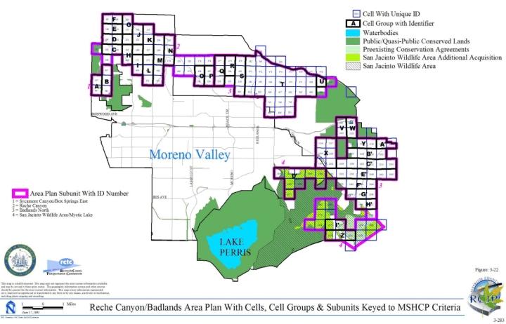
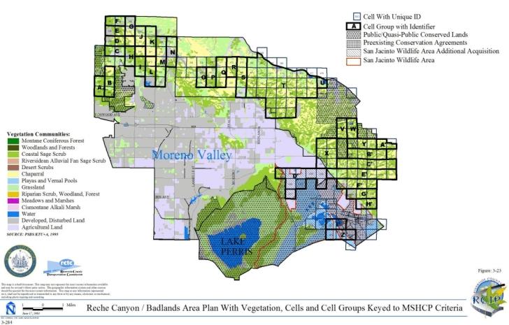
3.3.12 REMAP Area Plan
➤ Target Acreages
➤ Applicable Cores and Linkages
➤ Area Plan Subunits
TABLE 3-13
CRITERIA FOR REMAP AREA PLAN
| Sub Unit |
Cell Group | Quadrat Number |
USGS Section |
Quarter Section |
Criteria |
|---|---|---|---|---|---|
| SUBUNIT 1 - Cactus Valley | |||||
| 1 | C | 4500 | 04 | NW | Conservation within this Cell Group will contribute to assembly of Proposed Core 4. Conservation within this Cell Group will focus on chaparral, coastal sage scrub, woodland and forest habitat. Areas conserved within this Cell Group will be connected to chaparral and coastal sage scrub habitat proposed for conservation in Cell Groups D to the east and I to the south, to chaparral, coastal sage scrub, woodland and forest habitat proposed for conservation in Cell Group L' in the San Jacinto Area Plan to the west, and to chaparral habitat proposed for conservation in Cell Group F' in the San Jacinto Area Plan to the north. Conservation within this Cell Group will be approximately 90% of the Cell Group focusing in the southern portion of the Cell Group. |
| 1 | C | 4546 | 04 | SW | |
| 1 | C | 4638 | 09 | NW | |
| 1 | C | 4734 | 09 | SW | |
| 1 | D | 4485 | 04 | NE | Conservation within this Cell Group will contribute to assembly of Proposed Core 4. Conservation within this Cell Group will focus on chaparral, coastal sage scrub, woodland and forest habitat. Areas conserved within this Cell Group will be connected to chaparral and coastal sage scrub habitat proposed for conservation in Cell Groups C to the west and E to the east and to chaparral habitat proposed for conservation in Cell Group H to the south. Conservation within this Cell Group will range from 75%-85% of the Cell Group focusing in the southern portion of the Cell Group. |
| 1 | D | 4560 | 04 | SE | |
| 1 | D | 4640 | 09 | NE | |
| 1 | D | 4736 | 09 | SE | |
| 1 | D'' | 4626 | 01 | SE | Conservation within this Cell Group will contribute to assembly of Proposed Core 4. Conservation within this Cell Group will focus on chaparral and Riversidean alluvial fan sage scrub habitat. Areas conserved within this Cell Group will be connected to chaparral and Riversidean alluvial fan sage scrub habitat proposed for conservation in Cell #4511 to the north. Conservation within this Cell Group will range from 50%-60% of the Cell Group focusing in the western portion of the Cell Group. |
| 1 | D'' | 4627 | 01 | SW | |
| 1 | E | 4486 | 03 | NW | Conservation within this Cell Group will contribute to assembly of Proposed Core 4. Conservation within this Cell Group will focus on chaparral, coastal sage scrub, riparian scrub, woodland and forest habitat. Areas conserved within this Cell Group will be connected to chaparral habitat proposed for conservation in Cell Group D to the west and in Cell Group K' in the San Jacinto Area Plan to the north. Conservation within this Cell Group will be approximately 90% of the Cell Group. |
| 1 | E | 4488 | 03 | NE | |
| 1 | E | 4620 | 03 | SW | |
| 1 | E | 4622 | 03 | SE | |
| 1 | F | 4912 | 15 | NW | Conservation within this Cell Group will contribute to assembly of Proposed Core 4. Conservation within this Cell Group will focus on chaparral, grassland, woodland and forest habitat. Areas conserved within this Cell Group will be connected to chaparral habitat proposed for conservation in Cell Group G to the east and to chaparral, woodland, and forest habitat proposed for conservation in Cell Group H to the west. Conservation within this Cell Group will range from 80%-90% of the Cell Group focusing in the northern portion of the Cell Group. |
| 1 | F | 5010 | 15 | SW | |
| 1 | F | 5111 | 22 | NW | |
| 1 | G | 4913 | 15 | NE | Conservation within this Cell Group will contribute to assembly of Proposed Core 4. Conservation within this Cell Group will focus on chaparral, woodland and forest habitat. Areas conserved within this Cell Group will be connected to chaparral habitat proposed for conservation in Cell Group F to the west. Conservation within this Cell Group will range from 75%-85% of the Cell Group focusing in the northern portion of the Cell Group. |
| 1 | G | 5011 | 15 | SE | |
| 1 | G | 5108 | 22 | NE | |
| 1 | H | 4832 | 16 | NE | Conservation within this Cell Group will contribute to assembly of Proposed Core 4. Conservation within this Cell Group will focus on chaparral, woodland and forest habitat. Areas conserved within this Cell Group will be connected to chaparral and coastal sage scrub habitat proposed for conservation in Cell Group D to the north, to chaparral, woodland, and forest habitat proposed for conservation in Cell Group I to the west, and to chaparral, grassland, woodland, and forest habitat proposed for conservation in Cell Group F to the east. Conservation within this Cell Group will be approximately 90% of the Cell Group focusing in the northern portion of the Cell Group. |
| 1 | H | 4930 | 16 | SE | |
| 1 | H | 5028 | 21 | NE | |
| 1 | I | 4830 | 16 | NW | Conservation within this Cell Group will contribute to assembly of Proposed Core 4. Conservation within this Cell Group will focus on chaparral, coastal sage scrub, woodland and forest habitat. Areas conserved within this Cell Group will be connected to chaparral and coastal sage scrub habitat proposed for conservation in Cell Group C to the north, to chaparral, woodland, and forest habitat proposed for conservation in Cell Group H to the east, and to chaparral, grassland, woodland, and forest habitat proposed for conservation in Cell Group J to the west. Conservation within this Cell Group will range from 75%-85% of the Cell Group focusing in the northern portion of the Cell Group. |
| 1 | I | 4929 | 16 | SW | |
| 1 | I | 5029 | 21 | NW | |
| 1 | I | 5127 | 21 | SW | |
| 1 | J | 4825 | 18 | NW | Conservation within this Cell Group will contribute to assembly of Proposed Core 4. Conservation within this Cell Group will focus on chaparral, coastal sage scrub, grassland, woodland and forest habitat. Areas conserved within this Cell Group will be connected to chaparral, woodland, and forest habitat proposed for conservation in Cell Groups K to the west and I to the east, and to upland habitat proposed for conservation in Cell Groups I', E', J', L' in the San Jacinto Area Plan to the north and in Cell Groups O' and S' in the San Jacinto Area Plan to the west. Conservation within this Cell Group will range from 60%-70% of the Cell Group focusing in the northern portion of the Cell Group. |
| 1 | J | 4826 | 18 | NE | |
| 1 | J | 4827 | 17 | NW | |
| 1 | J | 4828 | 17 | NE | |
| 1 | J | 4922 | 18 | SW | |
| 1 | J | 4925 | 17 | SW | |
| 1 | J | 4927 | 17 | SE | |
| 1 | J | 5022 | 19 | NW | |
| 1 | J | 5023 | 19 | NE | |
| 1 | J | 5025 | 20 | NW | |
| 1 | J | 5027 | 20 | NE | |
| 1 | J | 5119 | 19 | SW | |
| 1 | J | 5121 | 19 | SE | |
| 1 | J | 5122 | 20 | SW | |
| 1 | J | 5125 | 20 | SE | |
| 1 | J | 5219 | 30 | NE | |
| 1 | J | 5220 | 29 | NW | |
| 1 | J | 5221 | 30 | NW | |
| 1 | K | 5083 | 23 | NE | Conservation within this Cell Group will contribute to assembly of Proposed Linkage 14. Conservation within this Cell Group will focus on chaparral, coastal sage scrub, grassland, Riversidean alluvial fan sage scrub, riparian scrub, woodland and forest habitat. Areas conserved within this Cell Group will be connected to chaparral, coastal sage scrub, woodland, and forest habitat proposed for conservation in Cell Group J to the east, to chaparral, grassland, Riversidean alluvial fan sage scrub, riparian scrub, woodland and forest habitat proposed for conservation in Cell Group S' in the San Jacinto Area Plan to the north, and to chaparral and grassland habitat proposed for conservation in Cell Group K in the Southwest Area Plan to the west. Conservation within this Cell Group will range from 70%-80% of the Cell Group focusing in the northern portion of the Cell Group. |
| 1 | K | 5084 | 24 | NW | |
| 1 | K | 5085 | 23 | NW | |
| 1 | K | 5094 | 24 | NE | |
| 1 | K | 5180 | 23 | SE | |
| 1 | K | 5181 | 24 | SW | |
| 1 | K | 5185 | 23 | SW | |
| 1 | K | 5194 | 24 | SE | |
| 1 | K | 5277 | 25 | NW | |
| 1 | K | 5290 | 25 | NE | |
| 1 | 4511 | 01 | NW | Conservation within this Cell will contribute to assembly of Proposed Core 4. Conservation within this Cell will focus on chaparral and Riversidean alluvial fan sage scrub habitat. Areas conserved within this Cell will be connected to chaparral habitat proposed for conservation in Cell Group D" to the south and to chaparral and Riversidean alluvial fan sage scrub habitat proposed for conservation in Cell Group N' in the San Jacinto Area Plan to the northwest. Conservation within this Cell will range from 40%-50% of the Cell focusing in the southwestern portion of the Cell. | |
| SUBUNIT 2 - Wilson Valley/Sage | |||||
| 2 | A' | 6009 | 07 | SE | Conservation within this Cell Group will contribute to assembly of Proposed Core 7. Conservation within this Cell Group will focus on chaparral, grassland, riparian scrub, woodland and forest habitat. Areas conserved within this Cell Group will be connected to chaparral, woodland and forest habitat proposed for conservation in Cell Group Z to the north and to chaparral, grassland, riparian scrub, woodland and forest habitat proposed for conservation in Cell Group B' to the south. Conservation within this Cell Group will range from 60%-70% of the Cell Group focusing in the western portion of the Cell Group. |
| 2 | A' | 6010 | 07 | SW | |
| 2 | A' | 6015 | 12 | SE | |
| 2 | B' | 6024 | 11 | SE | Conservation within this Cell Group will contribute to assembly of Proposed Core 7. Conservation within this Cell Group will focus on chaparral, coastal sage scrub, grassland, Riversidean alluvial fan sage scrub, riparian scrub, woodland and forest habitat. Areas conserved within this Cell Group will be connected to chaparral, grassland, riparian scrub, woodland and forest habitat proposed for conservation in Cell Group A' to the north, to chaparral habitat proposed for conservation in Cell Group Y also to the north, to chaparral, woodland and forest habitat proposed for conservation in Cell Group C' to the west, and to chaparral, coastal sage scrub, riparian scrub, woodland and forest habitat proposed for conservation in Cell Group D' to the south. Conservation within this Cell Group will range from 80%-90% of the Cell Group focusing in the eastern portion of the Cell Group. |
| 2 | B' | 6114 | 13 | NE | |
| 2 | B' | 6122 | 13 | NW | |
| 2 | B' | 6131 | 14 | NE | |
| 2 | B' | 6211 | 13 | SE | |
| 2 | B' | 6214 | 13 | SW | |
| 2 | B' | 6218 | 14 | SE | |
| 2 | B' | 6312 | 24 | NE | |
| 2 | B' | 6313 | 24 | NW | |
| 2 | B' | 6316 | 23 | NE | |
| 2 | B' | 6322 | 23 | NW | |
| 2 | C' | 6028 | 11 | SW | Conservation within this Cell Group will contribute to assembly of Proposed Core 7. Conservation within this Cell Group will focus on chaparral, woodland and forest habitat. Areas conserved within this Cell Group will be connected to chaparral, woodland and forest habitat proposed for conservation in Cell Groups Y to the north and B' to the east, and to chaparral habitat proposed for conservation in Cell #6089 to the west. Conservation within this Cell Group will range from 65%-75% of the Cell Group focusing in the northern portion of the Cell Group. |
| 2 | C' | 6134 | 14 | NW | |
| 2 | D' | 6385 | 22 | SW | Conservation within this Cell Group will contribute to assembly of Proposed Core 7. Conservation within this Cell Group will focus on chaparral, coastal sage scrub, grassland, Riversidean alluvial fan sage scrub, riparian scrub, woodland and forest habitat. Areas conserved within this Cell Group will be connected to chaparral, coastal sage scrub, grassland, Riversidean alluvial fan sage scrub, riparian scrub, woodland and forest habitat proposed for conservation in Cell Group B' to the north, to chaparral, coastal sage scrub, grassland, and Riversidean alluvial fan sage scrub habitat proposed for conservation in Cell Group E' to the south, and to chaparral and desert scrub habitat proposed for conservation in Cell Group V to the west. Conservation within this Cell Group will range from 70%-80% of the Cell Group focusing in the eastern portion of the Cell Group. |
| 2 | D' | 6394 | 22 | SE | |
| 2 | D' | 6417 | 23 | SE | |
| 2 | D' | 6418 | 24 | SW | |
| 2 | D' | 6420 | 24 | SE | |
| 2 | D' | 6421 | 23 | SW | |
| 2 | E' | 6488 | 30 | NW | Conservation within this Cell Group will contribute to assembly of Proposed Core 7. Conservation within this Cell Group will focus on chaparral, coastal sage scrub, desert scrub, grassland, Riversidean alluvial fan sage scrub, riparian scrub, woodland and forest habitat. Areas conserved within this Cell Group will be connected to coastal sage scrub and grassland habitat proposed for conservation in Cell Group F' to the west, to coastal sage scrub habitat proposed for conservation in Cell Groups U to the north, P', Q', S' and U' to the south, to chaparral and coastal sage scrub habitat proposed for conservation in Cell Groups E", G", R' and T' to the south, to chaparral, coastal sage scrub, desert scrub, and grassland habitat proposed for conservation in Cell Group V to the north, to chaparral, coastal sage scrub, grassland, and Riversidean alluvial fan sage scrub habitat proposed for conservation in Cell Group D' also to the north, and to chaparral, coastal sage scrub, grassland, riparian scrub, woodland, and forest habitat proposed for conservation in Cell Group D in the Southwest Area Plan also to the west. Conservation within this Cell Group will range from 80%-90% of the Cell Group focusing in the western portion of the Cell Group. |
| 2 | E' | 6489 | 30 | NE | |
| 2 | E' | 6490 | 29 | NW | |
| 2 | E' | 6491 | 29 | NE | |
| 2 | E' | 6492 | 28 | NW | |
| 2 | E' | 6493 | 28 | NE | |
| 2 | E' | 6495 | 27 | NW | |
| 2 | E' | 6504 | 27 | NE | |
| 2 | E' | 6515 | 26 | NW | |
| 2 | E' | 6517 | 26 | NE | |
| 2 | E' | 6520 | 25 | NW | |
| 2 | E' | 6524 | 25 | NE | |
| 2 | E' | 6597 | 30 | SE | |
| 2 | E' | 6598 | 29 | SW | |
| 2 | E' | 6599 | 29 | SE | |
| 2 | E' | 6600 | 28 | SW | |
| 2 | E' | 6601 | 28 | SE | |
| 2 | E' | 6602 | 27 | SW | |
| 2 | E' | 6608 | 27 | SE | |
| 2 | E' | 6609 | 26 | SW | |
| 2 | E' | 6610 | 26 | SE | |
| 2 | E' | 6611 | 25 | SW | |
| 2 | E' | 6612 | 25 | SE | |
| 2 | E' | 6704 | 31 | NW | |
| 2 | E' | 6705 | 31 | NE | |
| 2 | E' | 6706 | 32 | NW | |
| 2 | E' | 6707 | 32 | NE | |
| 2 | E' | 6708 | 33 | NW | |
| 2 | E' | 6711 | 33 | NE | |
| 2 | E' | 6713 | 34 | NW | |
| 2 | E' | 6716 | 34 | NE | |
| 2 | E' | 6717 | 35 | NE | |
| 2 | E' | 6718 | 36 | NW | |
| 2 | E' | 6719 | 35 | NW | |
| 2 | E' | 6720 | 36 | NE | |
| 2 | E' | 6811 | 31 | SW | |
| 2 | E' | 6812 | 31 | SE | |
| 2 | E' | 6813 | 32 | SW | |
| 2 | E' | 6814 | 32 | SE | |
| 2 | E' | 6815 | 33 | SW | |
| 2 | E' | 6818 | 33 | SE | |
| 2 | E' | 6821 | 34 | SW | |
| 2 | E' | 6823 | 34 | SE | |
| 2 | E' | 6824 | 35 | SE | |
| 2 | E' | 6825 | 36 | SW | |
| 2 | E' | 6826 | 35 | SW | |
| 2 | E' | 6827 | 36 | SE | |
| 2 | E' | 6828 | 31 | SW | |
| 2 | E' | 6905 | 06 | NW | |
| 2 | E' | 6908 | 06 | NE | |
| 2 | E' | 6912 | 05 | NW | |
| 2 | E' | 6916 | 05 | NE | |
| 2 | E' | 6922 | 04 | NW | |
| 2 | E' | 6931 | 03 | NW | |
| 2 | E' | 6932 | 01 | NE | |
| 2 | E' | 6933 | 06 | NW | |
| 2 | E' | 6934 | 01 | NW | |
| 2 | E' | 6935 | 02 | NE | |
| 2 | E' | 6936 | 03 | NE | |
| 2 | E' | 6937 | 02 | NW | |
| 2 | E' | 6976 | 06 | SW | |
| 2 | E' | 6980 | 06 | SE | |
| 2 | E' | 6990 | 05 | SW | |
| 2 | E' | 6994 | 05 | SE | |
| 2 | E' | 6997 | 04 | SW | |
| 2 | E' | 6998 | 04 | SE | |
| 2 | E' | 7002 | 03 | SW | |
| 2 | E' | 7004 | 03 | SE | |
| 2 | E' | 7007 | 02 | SW | |
| 2 | E' | 7009 | 02 | SE | |
| 2 | E' | 7017 | 01 | SW | |
| 2 | E' | 7018 | 06 | SW | |
| 2 | E' | 7019 | 01 | SE | |
| 2 | E' | 7094 | 07 | NW | |
| 2 | E' | 7095 | 07 | NE | |
| 2 | E' | 7096 | 08 | NW | |
| 2 | E' | 7098 | 08 | NE | |
| 2 | E' | 7100 | 09 | NW | |
| 2 | E' | 7103 | 09 | NE | |
| 2 | E' | 7106 | 10 | NW | |
| 2 | E' | 7112 | 10 | NE | |
| 2 | E' | 7114 | 11 | NW | |
| 2 | E' | 7115 | 11 | NE | |
| 2 | E' | 7120 | 12 | NW | |
| 2 | E' | 7123 | 12 | NE | |
| 2 | E' | 7130 | 07 | NW | |
| 2 | E' | 7187 | 07 | SW | |
| 2 | E' | 7189 | 07 | SE | |
| 2 | E' | 7192 | 08 | SW | |
| 2 | E' | 7197 | 08 | SE | |
| 2 | E' | 7200 | 09 | SW | |
| 2 | E' | 7206 | 09 | SE | |
| 2 | E' | 7209 | 10 | SW | |
| 2 | E' | 7218 | 10 | SE | |
| 2 | E' | 7223 | 12 | SE | |
| 2 | E' | 7224 | 07 | SW | |
| 2 | E' | 7225 | 12 | SW | |
| 2 | E' | 7227 | 11 | SE | |
| 2 | E' | 7229 | 11 | SW | |
| 2 | E' | 7291 | 18 | NW | |
| 2 | E' | 7292 | 18 | NE | |
| 2 | E' | 7293 | 17 | NW | |
| 2 | E' | 7294 | 17 | NE | |
| 2 | E' | 7295 | 16 | NW | |
| 2 | E' | 7296 | 16 | NE | |
| 2 | E' | 7297 | 15 | NW | |
| 2 | E' | 7307 | 15 | NE | |
| 2 | E' | 7314 | 13 | NE | |
| 2 | E' | 7315 | 18 | NW | |
| 2 | E' | 7320 | 14 | NW | |
| 2 | E' | 7325 | 13 | NW | |
| 2 | E' | 7332 | 14 | NE | |
| 2 | E' | 7334 | 18 | NE | |
| 2 | E' | 7381 | 18 | SW | |
| 2 | E' | 7382 | 18 | SE | |
| 2 | E' | 7383 | 17 | SW | |
| 2 | E' | 7384 | 17 | SE | |
| 2 | E' | 7385 | 16 | SW | |
| 2 | E' | 7386 | 16 | SE | |
| 2 | E' | 7387 | 15 | SW | |
| 2 | E' | 7393 | 13 | SE | |
| 2 | E' | 7394 | 18 | SW | |
| 2 | E' | 7399 | 13 | SW | |
| 2 | E' | 7400 | 15 | SE | |
| 2 | E' | 7408 | 14 | SE | |
| 2 | E' | 7411 | 14 | SW | |
| 2 | E' | 7413 | 18 | SE | |
| 2 | E' | 7485 | 22 | NW | |
| 2 | F' | 6487 | 25 | NE | Conservation within this Cell Group will contribute to assembly of Proposed Core 7. Conservation within this Cell Group will focus on chaparral, coastal sage scrub, grassland, riparian scrub, woodland and forest habitat. Areas conserved within this Cell Group will be connected to chaparral habitat proposed for conservation in Cell Group G' to the west, to coastal sage scrub and grassland habitat proposed for conservation in Cell Group E' to the east, and to grassland habitat proposed for conservation in Cell Group D in the Southwest Area Plan to the south. Conservation within this Cell Group will range from 45%-55% of the Cell Group focusing in the southern portion of the Cell Group. |
| 2 | F' | 6595 | 25 | SE | |
| 2 | F' | 6703 | 36 | NE | |
| 2 | F' | 6810 | 36 | SE | |
| 2 | G' | 6486 | 25 | NW | Conservation within this Cell Group will contribute to assembly of Proposed Core 7. Conservation within this Cell Group will focus on chaparral, coastal sage scrub, Riversidean alluvial fan sage scrub, riparian scrub, woodland and forest habitat. Areas conserved within this Cell Group will be connected to coastal sage scrub and grassland habitat proposed for conservation in Cell Group H' to the west, to chaparral habitat proposed for conservation in Cell Group F' to the east, and to chaparral, coastal sage scrub, woodland and forest habitat proposed for conservation in Cell Group D in the Southwest Area Plan to the south. Conservation within this Cell Group will range from 45%-55% of the Cell Group focusing in the southern portion of the Cell Group. |
| 2 | G' | 6594 | 25 | SW | |
| 2 | G' | 6702 | 36 | NW | |
| 2 | G' | 6804 | 36 | SW | |
| 2 | G'' | 7468 | 19 | NE | Conservation within this Cell Group will contribute to assembly of Proposed Core 7. Conservation within this Cell Group will focus on chaparral and coastal sage scrub habitat. Areas conserved within this Cell Group will be connected to chaparral, coastal sage scrub and grassland habitat proposed for conservation in Cell Group E' to the north, to chaparral and coastal sage scrub habitat proposed for conservation in Cell Group H" to the south, to chaparral habitat proposed for conservation in Cell Group F" also to the south, and to chaparral, coastal sage scrub, riparian scrub, woodland and forest habitat proposed for conservation in Cell Group D in the Southwest Area Plan to the west. Conservation within this Cell Group will range from 60%-70% of the Cell Group focusing in the eastern portion of the Cell Group. |
| 2 | G'' | 7469 | 20 | NW | |
| 2 | G'' | 7470 | 19 | NW | |
| 2 | G'' | 7471 | 20 | NE | |
| 2 | G'' | 7474 | 21 | NW | |
| 2 | H' | 6485 | 26 | NE | Conservation within this Cell Group will contribute to assembly of Proposed Core 7. Conservation within this Cell Group will focus on chaparral, coastal sage scrub and grassland habitat. Areas conserved within this Cell Group will be connected to coastal sage scrub habitat proposed for conservation in Cell Group G' to the east and in Cell Group D in the Southwest Area Plan to the south, and to chaparral, coastal sage scrub, and grassland habitat proposed for conservation in Cell Group I' to the west. Conservation within this Cell Group will range from 45%-55% of the Cell Group focusing in the southern portion of the Cell Group. |
| 2 | H' | 6593 | 26 | SE | |
| 2 | H' | 6701 | 35 | NE | |
| 2 | H' | 6802 | 35 | SE | |
| 2 | H'' | 7555 | 20 | SW | Conservation within this Cell Group will contribute to assembly of Proposed Core 7. Conservation within this Cell Group will focus on chaparral, coastal sage scrub, riparian scrub, woodland and forest habitat. Areas conserved within this Cell Group will be connected to chaparral and coastal sage scrub habitat proposed for conservation in Cell Groups G" to the north, F" to the west, and J' and K' both to the south. Conservation within this Cell Group will range from 55%-65% of the Cell Group focusing in the central portion of the Cell Group. |
| 2 | H'' | 7558 | 20 | SE | |
| 2 | H'' | 7579 | 21 | SW | |
| 2 | H'' | 7581 | 21 | SE | |
| 2 | I' | 6483 | 26 | NW | Conservation within this Cell Group will contribute to assembly of Proposed Core 7. Conservation within this Cell Group will focus on chaparral, coastal sage scrub, grassland, woodland and forest habitat. Areas conserved within this Cell Group will be connected to chaparral, coastal sage scrub, and grassland habitat proposed for conservation in Cell Group H' to the east and to chaparral and coastal sage scrub habitat proposed for conservation in Cell Group B in the Southwest Area Plan to the west and in Cell Group D also in the Southwest Area Plan to the south. Conservation within this Cell Group will range from 45%-55% of the Cell Group focusing in the southern portion of the Cell Group. |
| 2 | I' | 6591 | 26 | SW | |
| 2 | I' | 6699 | 35 | NW | |
| 2 | I' | 6800 | 35 | SW | |
| 2 | K' | 7667 | 28 | NE | Conservation within this Cell Group will contribute to assembly of Proposed Core 7. Conservation within this Cell Group will focus on chaparral and coastal sage scrub habitat. Areas conserved within this Cell Group will be connected to coastal sage scrub and chaparral habitat proposed for conservation in Cell Group H" to the north and to coastal sage scrub habitat proposed for conservation in Cell #7737 to the south. Conservation within this Cell Group will range from 65%-75% of the Cell Group focusing in the eastern portion of the Cell Group. |
| 2 | K' | 7668 | 28 | NW | |
| 2 | L | 5322 | 30 | SE | Conservation within this Cell Group will contribute to assembly of Proposed Linkage 13. Conservation within this Cell Group will focus on chaparral, coastal sage scrub, grassland, riparian scrub, woodland and forest habitat. Areas conserved within this Cell Group will be connected to chaparral and coastal sage scrub habitat proposed for conservation in Cell Groups M to the west and S to the south. Conservation within this Cell Group will range from 5%-15% of the Cell Group focusing in the southwestern portion of the Cell Group. |
| 2 | L | 5324 | 30 | SW | |
| 2 | L | 5384 | 25 | SW | |
| 2 | L | 5385 | 25 | SE | |
| 2 | L | 5426 | 31 | NW | |
| 2 | L | 5491 | 36 | NW | |
| 2 | L | 5506 | 36 | NE | |
| 2 | L | 5528 | 31 | SW | |
| 2 | L | 5598 | 36 | SW | |
| 2 | L | 5602 | 36 | SE | |
| 2 | L | 5632 | 06 | NW | |
| 2 | L | 5697 | 01 | NE | |
| 2 | L | 5699 | 01 | NW | |
| 2 | L | 5731 | 06 | SW | |
| 2 | L | 5749 | 01 | SW | |
| 2 | L | 5750 | 01 | SE | |
| 2 | L | 5846 | 12 | NW | |
| 2 | L | 5847 | 12 | NE | |
| 2 | L | 5848 | 07 | NW | |
| 2 | M | 5490 | 35 | NE | Conservation within this Cell Group will contribute to assembly of Proposed Linkage 13. Conservation within this Cell Group will focus on chaparral, coastal sage scrub, grassland, woodland and forest habitat. Areas conserved within this Cell Group will be connected to chaparral, coastal sage scrub, and grassland habitat proposed for conservation in Cell Group L to the east, to chaparral and coastal sage scrub habitat proposed for conservation in Cell Group N to the west, and to chaparral, coastal sage scrub, woodland, and forest habitat proposed for conservation in Cell Group Q to the south. Conservation within this Cell Group will range from 50%-60% of the Cell Group focusing in the southern portion of the Cell Group. |
| 2 | M | 5597 | 35 | SE | |
| 2 | M | 5698 | 02 | NE | |
| 2 | M | 5748 | 02 | SE | |
| 2 | M | 5845 | 11 | NE | |
| 2 | N | 5496 | 35 | NW | Conservation within this Cell Group will contribute to assembly of Proposed Linkage 13. Conservation within this Cell Group will focus on chaparral, coastal sage scrub, grassland, woodland and forest habitat. Areas conserved within this Cell Group will be connected to chaparral and coastal sage scrub habitat proposed for conservation in Cell Group M to the east and in Cell Group L in the Southwest Area Plan to the west, and to chaparral, coastal sage scrub, and grassland habitat proposed for conservation in Cell Group M also in the Southwest Area Plan to the west. Conservation within this Cell Group will range from 35%-45% of the Cell Group focusing in the southern portion of the Cell Group. |
| 2 | N | 5600 | 35 | SW | |
| 2 | N | 5695 | 02 | NW | |
| 2 | N | 5747 | 02 | SW | |
| 2 | N | 5844 | 11 | NW | |
| 2 | P | 5948 | 11 | SW | Conservation within this Cell Group will contribute to assembly of Proposed Core 7. Conservation within this Cell Group will focus on chaparral, coastal sage scrub, woodland and forest habitat. Areas conserved within this Cell Group will be connected to chaparral, coastal sage scrub, woodland and forest habitat proposed for conservation in Cell Group Q to the east. Conservation within this Cell Group will range from 5%-15% of the Cell Group focusing in the northern portion of the Cell Group. |
| 2 | P | 6053 | 14 | NW | |
| 2 | P | 6161 | 14 | SW | |
| 2 | P | 6268 | 23 | NW | |
| 2 | P | 6375 | 23 | SW | |
| 2 | Q | 5950 | 11 | SE | Conservation within this Cell Group will contribute to assembly of Proposed Core 7. Conservation within this Cell Group will focus on chaparral, coastal sage scrub, grassland, woodland and forest habitat. Areas conserved within this Cell Group will be connected to chaparral, coastal sage scrub, woodland and forest habitat proposed for conservation in Cell Group P to the west, to chaparral and coastal sage scrub habitat proposed for conservation in Cell Group R to the east, and to chaparral, coastal sage scrub, grassland, woodland and forest habitat proposed for conservation in Cell Group M to the north. Conservation within this Cell Group will range from 35%-45% of the Cell Group focusing in the northern portion of the Cell Group. |
| 2 | Q | 6055 | 14 | NE | |
| 2 | Q | 6162 | 14 | SE | |
| 2 | Q | 6269 | 23 | NE | |
| 2 | Q | 6376 | 23 | SE | |
| 2 | R | 5951 | 12 | SW | Conservation within this Cell Group will contribute to assembly of Proposed Core 7. Conservation within this Cell Group will focus on chaparral, coastal sage scrub, grassland, woodland and forest habitat. Areas conserved within this Cell Group will be connected to chaparral, coastal sage scrub, grassland, woodland and forest habitat proposed for conservation in Cell Groups Q to the west and S to the east. Conservation within this Cell Group will range from 30%-40% of the Cell Group focusing in the northern portion of the Cell Group. |
| 2 | R | 6056 | 13 | NW | |
| 2 | R | 6163 | 13 | SW | |
| 2 | R | 6270 | 24 | NW | |
| 2 | R | 6377 | 24 | SW | |
| 2 | S | 5952 | 12 | SE | Conservation within this Cell Group will contribute to assembly of Proposed Core 7. Conservation within this Cell Group will focus on chaparral, coastal sage scrub, grassland, riparian scrub, woodland and forest habitat. Areas conserved within this Cell Group will be connected to chaparral, coastal sage scrub, grassland, woodland and forest habitat proposed for conservation in Cell Group R to the west, to chaparral, coastal sage scrub, and grassland habitat proposed for conservation in Cell Group T to the east, and to chaparral and coastal sage scrub habitat proposed for conservation in Cell Group L to the north. Conservation within this Cell Group will range from 40%-50% of the Cell Group focusing in the northern portion of the Cell Group. |
| 2 | S | 6057 | 13 | NE | |
| 2 | S | 6164 | 13 | SE | |
| 2 | S | 6271 | 24 | NE | |
| 2 | S | 6378 | 24 | SE | |
| 2 | T | 5953 | 07 | SW | Conservation within this Cell Group will contribute to assembly of Proposed Core 7. Conservation within this Cell Group will focus on chaparral, coastal sage scrub, and grassland habitat. Areas conserved within this Cell Group will be connected to chaparral, coastal sage scrub, and grassland habitat proposed for conservation in Cell Groups S to the west and U to the east. Conservation within this Cell Group will range from 50%-60% of the Cell Group focusing in the northern portion of the Cell Group. |
| 2 | T | 6060 | 18 | NW | |
| 2 | T | 6167 | 18 | SW | |
| 2 | T | 6272 | 19 | NW | |
| 2 | T | 6379 | 19 | SW | |
| 2 | U | 5634 | 06 | NE | Conservation within this Cell Group will contribute to assembly of Proposed Core 7. Conservation within this Cell Group will focus on chaparral, coastal sage scrub, desert scrub, and grassland habitat. Areas conserved within this Cell Group will be connected to chaparral, coastal sage scrub, and grassland habitat proposed for conservation in Cell Group T to the west, to chaparral and coastal sage scrub habitat proposed for conservation in Cell Group E' to the south, to chaparral, coastal sage scrub, desert scrub and grassland habitat proposed for conservation in Cell Group V to the east, and to chaparral and grassland habitat proposed for conservation in Cell Group W also to the east. Conservation within this Cell Group will range from 55%-65% of the Cell Group focusing in the southern portion of the Cell Group. |
| 2 | U | 5732 | 06 | SE | |
| 2 | U | 5849 | 07 | NE | |
| 2 | U | 5954 | 07 | SE | |
| 2 | U | 6058 | 18 | NE | |
| 2 | U | 6165 | 18 | SE | |
| 2 | U | 6273 | 19 | NE | |
| 2 | U | 6380 | 19 | SE | |
| 2 | V | 6059 | 17 | NW | Conservation within this Cell Group will contribute to assembly of Proposed Core 7. Conservation within this Cell Group will focus on chaparral, coastal sage scrub, desert scrub, grassland, Riversidean alluvial fan sage scrub, riparian scrub, woodland and forest habitat. Areas conserved within this Cell Group will be connected to chaparral, coastal sage scrub, desert scrub and grassland habitat proposed for conservation in Cell Groups U to the west and E' to the south, to chaparral and grassland habitat proposed for conservation in Cell Group W to the north, to chaparral habitat proposed for conservation in Cell Group D' to the east and to coastal sage scrub and grassland habitat proposed for conservation in Cell #6064 also to the east. Conservation within this Cell Group will range from 80%-90% of the Cell Group focusing in the western portion of the Cell Group. |
| 2 | V | 6061 | 17 | NE | |
| 2 | V | 6062 | 16 | NW | |
| 2 | V | 6063 | 16 | NE | |
| 2 | V | 6166 | 17 | SW | |
| 2 | V | 6168 | 17 | SE | |
| 2 | V | 6169 | 16 | SW | |
| 2 | V | 6170 | 16 | SE | |
| 2 | V | 6274 | 20 | NW | |
| 2 | V | 6275 | 20 | NE | |
| 2 | V | 6276 | 21 | NW | |
| 2 | V | 6277 | 21 | NE | |
| 2 | V | 6381 | 20 | SW | |
| 2 | V | 6382 | 20 | SE | |
| 2 | V | 6383 | 21 | SW | |
| 2 | V | 6384 | 21 | SE | |
| 2 | W | 5850 | 08 | NW | Conservation within this Cell Group will contribute to assembly of Proposed Core 7. Conservation within this Cell Group will focus on chaparral, grassland, woodland and forest habitat. Areas conserved within this Cell Group will be connected to chaparral and grassland habitat proposed for conservation in Cell Group U to the west, to chaparral, coastal sage scrub, desert scrub and grassland habitat proposed for conservation in Cell Group V to the south, and to chaparral habitat proposed for conservation in Cell Group X to the east. Conservation within this Cell Group will range from 75%-85% of the Cell Group focusing in the southern portion of the Cell Group. |
| 2 | W | 5851 | 08 | NE | |
| 2 | W | 5852 | 09 | NW | |
| 2 | W | 5853 | 09 | NE | |
| 2 | W | 5955 | 08 | SW | |
| 2 | W | 5956 | 08 | SE | |
| 2 | W | 5957 | 09 | SW | |
| 2 | W | 5958 | 09 | SE | |
| 2 | X | 5854 | 10 | NW | Conservation within this Cell Group will contribute to assembly of Proposed Core 7. Conservation within this Cell Group will focus on chaparral, coastal sage scrub, woodland and forest habitat. Areas conserved within this Cell Group will be connected to chaparral, woodland and forest habitat proposed for conservation in Cell #5885 to the east, to chaparral, coastal sage scrub, woodland and forest habitat proposed for conservation in Cell #6064 to the south, and to chaparral habitat proposed for conservation in Cell Group W to the west. Conservation within this Cell Group will range from 75%-85% of the Cell Group focusing in the southern portion of the Cell Group. |
| 2 | X | 5959 | 10 | SW | |
| 2 | Y | 5914 | 11 | NE | Conservation within this Cell Group will contribute to assembly of Proposed Core 7. Conservation within this Cell Group will focus on chaparral, woodland and forest habitat. Areas conserved within this Cell Group will be connected to chaparral, woodland and forest habitat proposed for conservation in Cell Group C' to the south and to chaparral habitat proposed for conservation in Cell Group B' also to the south and in Cell #5915 to the east. Conservation within this Cell Group will be approximately 90% of the Cell Group focusing in the southern portion of the Cell Group. |
| 2 | Y | 5923 | 11 | NW | |
| 2 | Z | 5916 | 12 | NE | Conservation within this Cell Group will contribute to assembly of Proposed Core 7. Conservation within this Cell Group will focus on chaparral, grassland, woodland and forest habitat. Areas conserved within this Cell Group will be connected to chaparral, woodland and forest habitat proposed for conservation in Cell Group A' to the south. Conservation within this Cell Group will range from 65%-75% of the Cell Group focusing in the western portion of the Cell Group. |
| 2 | Z | 5917 | 07 | NW | |
| 2 | Z | 5919 | 07 | NE | |
| 2 | 5885 | 10 | NE | Conservation within this Cell will contribute to assembly of Proposed Core 7. Conservation within this Cell will focus on chaparral, woodland and forest habitat. Areas conserved within this Cell will be connected to chaparral, woodland and forest habitat proposed for conservation in Cell Group X to the west. Conservation within this Cell will range from 20%-30% of the Cell focusing in the western portion of the Cell. | |
| 2 | 5915 | 12 | NW | Conservation within this Cell will contribute to assembly of Proposed Core 7. Conservation within this Cell will focus on chaparral habitat. Areas conserved within this Cell will be connected to chaparral habitat proposed for conservation in Cell Group Y to the west. Conservation within this Cell will be approximately 5% of the Cell focusing in the western portion of the Cell Group. | |
| 2 | 6064 | 15 | NW | Conservation within this Cell will contribute to assembly of Proposed Core 7. Conservation within this Cell will focus on chaparral, coastal sage scrub, grassland, woodland and forest habitat. Areas conserved within this Cell will be connected to chaparral, coastal sage scrub, woodland and forest habitat proposed for conservation in Cell Group X to the north, to chaparral habitat proposed for conservation in Cell #6089 to the east, and to chaparral, coastal sage scrub, and grassland habitat proposed for conservation in Cell Group V to the west. Conservation within this Cell will range from 60%-70% of the Cell focusing in the northern portion of the Cell. | |
| 2 | 6089 | 15 | NE | Conservation within this Cell will contribute to assembly of Proposed Core 7. Conservation within this Cell will focus on chaparral habitat. Areas conserved within this Cell will be connected to chaparral habitat proposed for conservation in Cell #6064 to the west and to chaparral habitat proposed for conservation in Cell Group C' to the east. Conservation within this Cell will range from 50%-60% of the Cell focusing in the northern portion of the Cell. | |
| 2 | 7665 | 27 | NW | Conservation within this Cell will contribute to assembly of Proposed Core 7. Conservation within this Cell will focus on chaparral and coastal sage scrub habitat. Areas conserved within this Cell will be connected to chaparral and coastal sage scrub habitat proposed for conservation in Cell Group M' to the south, to chaparral habitat proposed for conservation in Cell #7663 to the east, and to coastal sage scrub habitat proposed for conservation in Cell Group K' to the west. Conservation within this Cell will range from 50%-60% of the Cell focusing in the southern portion of the Cell. | |
| SUBUNIT 3 - Temecula and Cottonwood Creeks | |||||
| 3 | F'' | 7553 | 19 | SW | Conservation within this Cell Group will contribute to assembly of Proposed Core 7. Conservation within this Cell Group will focus on chaparral, riparian scrub, woodland and forest habitat. Areas conserved within this Cell Group will be connected to chaparral and coastal sage scrub habitat proposed for conservation in Cell Groups G" to the north and H" to the east, to chaparral, riparian scrub, woodland and forest habitat proposed for conservation in Cell Group J' to the south, and to chaparral habitat proposed for conservation in Cell Group D in the Southwest Area Plan to the west. Conservation within this Cell Group will range from 55%-65% of the Cell Group focusing in the western portion of the Cell Group. |
| 3 | F'' | 7554 | 19 | SE | |
| 3 | J' | 7640 | 30 | NE | Conservation within this Cell Group will contribute to assembly of Proposed Core 7. Conservation within this Cell Group will focus on chaparral, coastal sage scrub, grassland, riparian scrub, woodland and forest habitat. Areas conserved within this Cell Group will be connected to chaparral, riparian scrub, woodland and forest habitat proposed for conservation in Cell Group F" to the north, to chaparral and coastal sage scrub habitat proposed for conservation in Cell Group H" also to the north, and to chaparral, coastal sage scrub, grassland, riparian scrub, woodland and forest habitat proposed for conservation in Cell Group L' to the south. Conservation within this Cell Group will range from 70%-80% of the Cell Group focusing in the western portion of the Cell Group. |
| 3 | J' | 7641 | 29 | NW | |
| 3 | J' | 7653 | 29 | NE | |
| 3 | L' | 7721 | 29 | SW | Conservation within this Cell Group will contribute to assembly of Proposed Core 7. Conservation within this Cell Group will focus on chaparral, coastal sage scrub, grassland, riparian scrub, woodland and forest habitat. Areas conserved within this Cell Group will be connected to chaparral, coastal sage scrub, grassland, riparian scrub, woodland and forest habitat proposed for conservation in Cell Group J' to the north and in Cell #7737 to the east, and to chaparral, riparian scrub, woodland and forest habitat proposed for conservation in Cell #7809 to the south. Conservation within this Cell Group will range from 60%-70% of the Cell Group focusing in the western portion of the Cell Group. |
| 3 | L' | 7731 | 29 | SE | |
| 3 | L' | 7741 | 28 | SW | |
| 3 | M' | 7738 | 27 | SW | Conservation within this Cell Group will contribute to assembly of Proposed Core 7. Conservation within this Cell Group will focus on chaparral, coastal sage scrub, grassland, and Riversidean alluvial fan sage scrub habitat. Areas conserved within this Cell Group will be connected to chaparral, coastal sage scrub, grassland, Riversidean alluvial fan sage scrub, riparian scrub, woodland and forest habitat proposed for conservation in Cell #7737 and #7805 both to the west, to grassland and Riversidean alluvial fan sage scrub habitat proposed for conservation in Cell #7881 to the south, to Riversidean alluvial fan sage scrub habitat proposed for conservation in Cell #7813 to the east, to chaparral, coastal sage scrub, and grassland habitat proposed for conservation in Cell #7743 also to the east, and to chaparral and coastal sage scrub habitat proposed for conservation in Cell #7665 to the north. Conservation within this Cell Group will range from 80%-90% of the Cell Group focusing in the northern portion of the Cell Group. |
| 3 | M' | 7806 | 34 | NW | |
| 3 | N' | 7744 | 26 | SW | Conservation within this Cell Group will contribute to assembly of Proposed Core 7. Conservation within this Cell Group will focus on chaparral and coastal sage scrub habitat. Areas conserved within this Cell Group will be connected to coastal sage scrub and Riversidean alluvial fan sage scrub habitat proposed for conservation in Cell #7813 to the northwest. Conservation within this Cell Group will range from 15%-25% of the Cell Group focusing in the southern portion of the Cell Group. |
| 3 | N' | 7745 | 26 | SE | |
| 3 | N' | 7824 | 35 | NW | |
| 3 | N' | 7826 | 35 | NE | |
| 3 | N' | 7888 | 35 | SW | |
| 3 | N' | 7891 | 35 | SE | |
| 3 | O' | 7746 | 25 | SE | Conservation within this Cell Group will contribute to assembly of Proposed Core 7. Conservation within this Cell Group will focus on chaparral, coastal sage scrub, grassland, and Riversidean alluvial fan sage scrub habitat. Conservation within this Cell Group will range from 5%-15% of the Cell Group focusing in the northwestern portion of the Cell Group. |
| 3 | O' | 7747 | 30 | SW | |
| 3 | O' | 7748 | 25 | SW | |
| 3 | O' | 7756 | 30 | SE | |
| 3 | O' | 7761 | 29 | SW | |
| 3 | O' | 7802 | 36 | NE | |
| 3 | O' | 7803 | 31 | NW | |
| 3 | O' | 7819 | 36 | NW | |
| 3 | O' | 7886 | 36 | SE | |
| 3 | O' | 7889 | 36 | SW | |
| 3 | 7737 | 28 | SE | Conservation within this Cell will contribute to assembly of Proposed Core 7. Conservation within this Cell will focus on chaparral, coastal sage scrub, grassland, Riversidean alluvial fan sage scrub, riparian scrub, woodland and forest habitat. Areas conserved within this Cell will be connected to chaparral, coastal sage scrub, grassland, riparian scrub, woodland and forest habitat proposed for conservation in Cell Group L' to the west, to chaparral, coastal sage scrub, grassland, and Riversidean alluvial fan sage scrub habitat proposed for conservation in Cell Group M' to the east, and to Riversidean alluvial fan sage scrub, riparian scrub, woodland and forest habitat proposed for conservation in Cell #7805 to the south. Conservation within this Cell will range from 75%-85% of the Cell focusing in the northern and southern portions of the Cell. | |
| 3 | 7743 | 27 | SE | Conservation within this Cell will contribute to assembly of Proposed Core 7. Conservation within this Cell will focus on chaparral, coastal sage scrub, grassland, and Riversidean alluvial fan sage scrub habitat. Areas conserved within this Cell will be connected to chaparral and coastal sage scrub habitat proposed for conservation in Cell #7663 to the north, to chaparral, coastal sage scrub, and Riversidean alluvial fan sage scrub habitat proposed for conservation in Cell Group M' to the west, and to coastal sage scrub and Riversidean alluvial fan sage scrub habitat proposed for conservation in Cell #7813 to the south. Conservation within this Cell will range from 70%-80% of the Cell focusing in the northwestern portion of the Cell. | |
| 3 | 7805 | 33 | NE | Conservation within this Cell will contribute to assembly of Proposed Core 7. Conservation within this Cell will focus on chaparral, coastal sage scrub, grassland, Riversidean alluvial fan sage scrub, riparian scrub, woodland and forest habitat. Areas conserved within this Cell will be connected to chaparral habitat proposed for conservation in Cell #7809 to the west, to Riversidean alluvial fan sage scrub, riparian scrub, woodland and forest habitat proposed for conservation in Cell #7737 to the north, to grassland and Riversidean alluvial fan sage scrub habitat proposed for conservation in Cell Group M' to the east, and to chaparral, coastal sage scrub, grassland, and Riversidean alluvial fan sage scrub habitat proposed for conservation in Cell #7880 to the south. Conservation within this Cell will range from 65%-75% of the Cell focusing in the eastern portion of the Cell. | |
| 3 | 7809 | 33 | NW | Conservation within this Cell will contribute to assembly of Proposed Core 7. Conservation within this Cell will focus on chaparral, coastal sage scrub, riparian scrub, woodland and forest habitat. Areas conserved within this Cell will be connected to chaparral, riparian scrub, woodland and forest habitat proposed for conservation in Cell Group L' to the north, and to riparian scrub, woodland, and forest habitat proposed for conservation in Cell #7805 to the east. Conservation within this Cell will range from 50%-60% of the Cell focusing in the southwestern portion of the Cell. | |
| 3 | 7813 | 34 | NE | Conservation within this Cell will contribute to assembly of Proposed Core 7. Conservation within this Cell will focus on coastal sage scrub and Riversidean alluvial fan sage scrub habitat. Areas conserved within this Cell will be connected to Riversidean alluvial fan sage scrub habitat proposed for conservation in Cell Group M' to the west, to coastal sage scrub and Riversidean alluvial fan sage scrub habitat proposed for conservation in Cell #7743 to the north, and to chaparral, coastal sage scrub, and Riversidean alluvial fan sage scrub habitat proposed for conservation in Cell Group N' to the southeast. Conservation within this Cell will range from 35%-45% of the Cell focusing in the northeastern portion of the Cell. | |
| 3 | 7880 | 33 | SE | Conservation within this Cell will contribute to assembly of Proposed Core 7. Conservation within this Cell will focus on chaparral, coastal sage scrub, grassland and Riversidean alluvial fan sage scrub habitat. Areas conserved within this Cell will be connected to chaparral, coastal sage scrub, grassland, and Riversidean alluvial fan sage scrub habitat proposed for conservation in Cell #7805 to the north, and to chaparral and Riversidean alluvial fan sage scrub habitat proposed for conservation in Cell #7881 to the east. Conservation within this Cell will range from 35%-45% of the Cell focusing in the northern portion of the Cell. | |
| 3 | 7881 | 34 | SW | Conservation within this Cell will contribute to assembly of Proposed Core 7. Conservation within this Cell will focus on chaparral, grassland and Riversidean alluvial fan sage scrub habitat. Areas conserved within this Cell will be connected to grassland and Riversidean alluvial fan sage scrub habitat proposed for conservation in Cell Group M' to the north, and to chaparral and Riversidean alluvial fan sage scrub habitat proposed for conservation in Cell #7880 to the west. Conservation within this Cell will range from 60%-70% of the Cell focusing in the northeastern portion of the Cell. | |
| SUBUNIT 4 - Tule Creek/Anza Valley | |||||
| 4 | A'' | 7153 | 11 | NW | Conservation within this Cell Group will contribute to assembly of Proposed Core 6. Conservation within this Cell Group will focus on chaparral, grassland, desert scrub, riparian scrub, woodland and forest habitat. Areas conserved within this Cell Group will be connected to chaparral, grassland, and desert scrub habitat proposed for conservation in Cell Group B" to the south. Conservation within this Cell Group will range from 30%-40% of the Cell Group focusing in the eastern portion of the Cell Group. |
| 4 | A'' | 7155 | 10 | NE | |
| 4 | A'' | 7156 | 11 | NE | |
| 4 | A'' | 7157 | 12 | NW | |
| 4 | A'' | 7159 | 12 | NE | |
| 4 | A'' | 7160 | 07 | NW | |
| 4 | A'' | 7162 | 07 | NE | |
| 4 | A'' | 7163 | 08 | NW | |
| 4 | A'' | 7165 | 08 | NE | |
| 4 | A'' | 7167 | 09 | NW | |
| 4 | A'' | 7247 | 12 | SE | |
| 4 | A'' | 7248 | 07 | SW | |
| 4 | A'' | 7249 | 10 | SE | |
| 4 | A'' | 7250 | 07 | SE | |
| 4 | A'' | 7251 | 08 | SW | |
| 4 | A'' | 7253 | 12 | SW | |
| 4 | A'' | 7255 | 08 | SE | |
| 4 | A'' | 7256 | 11 | SE | |
| 4 | A'' | 7257 | 11 | SW | |
| 4 | A'' | 7263 | 09 | SW | |
| 4 | A'' | 7265 | 09 | SE | |
| 4 | B'' | 7306 | 15 | NE | Conservation within this Cell Group will contribute to assembly of Proposed Linkage 16 and Proposed Core 6. Conservation within this Cell Group will focus on chaparral, grassland, desert scrub, riparian scrub, woodland and forest habitat. Areas conserved within this Cell Group will be connected to chaparral, grassland, and Riversidean alluvial fan sage scrub habitat proposed for conservation in Cell Group Z' to the west, to chaparral, desert scrub, grassland, riparian scrub, woodland and forest habitat proposed for conservation in Cell Group A" to the north, and to chaparral habitat proposed for conservation in Cell Group C" to the east and to the south. Conservation within this Cell Group will range from 65%-75% of the Cell Group focusing in the southeastern portion of the Cell Group. |
| 4 | B'' | 7321 | 13 | NE | |
| 4 | B'' | 7322 | 18 | NW | |
| 4 | B'' | 7326 | 18 | NE | |
| 4 | B'' | 7327 | 17 | NW | |
| 4 | B'' | 7329 | 17 | NE | |
| 4 | B'' | 7330 | 16 | NW | |
| 4 | B'' | 7331 | 16 | NE | |
| 4 | B'' | 7341 | 13 | NW | |
| 4 | B'' | 7345 | 14 | NE | |
| 4 | B'' | 7347 | 14 | NW | |
| 4 | B'' | 7390 | 17 | SE | |
| 4 | B'' | 7403 | 17 | SW | |
| 4 | B'' | 7416 | 18 | SE | |
| 4 | B'' | 7418 | 15 | SE | |
| 4 | B'' | 7419 | 18 | SW | |
| 4 | B'' | 7421 | 13 | SE | |
| 4 | B'' | 7427 | 13 | SW | |
| 4 | B'' | 7431 | 14 | SE | |
| 4 | B'' | 7432 | 14 | SW | |
| 4 | B'' | 7507 | 22 | NE | |
| 4 | B'' | 7513 | 19 | NE | |
| 4 | B'' | 7519 | 19 | NW | |
| 4 | B'' | 7521 | 23 | NW | |
| 4 | B'' | 7522 | 23 | NE | |
| 4 | B'' | 7523 | 24 | NE | |
| 4 | B'' | 7527 | 24 | NW | |
| 4 | B'' | 7571 | 20 | SW | |
| 4 | B'' | 7575 | 19 | SE | |
| 4 | B'' | 7580 | 24 | SE | |
| 4 | B'' | 7585 | 24 | SW | |
| 4 | B'' | 7599 | 22 | SE | |
| 4 | B'' | 7600 | 23 | SE | |
| 4 | B'' | 7602 | 23 | SW | |
| 4 | C'' | 7472 | 20 | NE | Conservation within this Cell Group will contribute to assembly of Proposed Core 6. Conservation within this Cell Group will focus on chaparral and grassland habitat. Areas conserved within this Cell Group will be connected to chaparral habitat proposed for conservation in Cell Group B" to the west and to the north. Conservation within this Cell Group will range from 70%-80% of the Cell Group focusing in the eastern portion of the Cell Group. |
| 4 | C'' | 7473 | 21 | NW | |
| 4 | C'' | 7490 | 21 | NE | |
| 4 | C'' | 7566 | 20 | SE | |
| 4 | C'' | 7568 | 21 | SW | |
| 4 | C'' | 7593 | 21 | SE | |
| 4 | E'' | 7497 | 22 | NE | Conservation within this Cell Group will contribute to assembly of Proposed Core 7. Conservation within this Cell Group will focus on chaparral, coastal sage scrub, and grassland habitat. Areas conserved within this Cell Group will be connected to chaparral and coastal sage scrub habitat proposed for conservation in Cell Group E' to the west and to the north, and to chaparral, coastal sage scrub, and grassland habitat proposed for conservation in Cell Group P' to the east. Conservation within this Cell Group will range from 50%-60% of the Cell Group focusing in the northern portion of the Cell Group. |
| 4 | E'' | 7591 | 22 | SE | |
| 4 | P' | 7501 | 23 | NW | Conservation within this Cell Group will contribute to assembly of Proposed Core 7. Conservation within this Cell Group will focus on chaparral, coastal sage scrub, grassland, Riversidean alluvial fan sage scrub, riparian scrub, woodland and forest habitat. Areas conserved within this Cell Group will be connected to chaparral and coastal sage scrub habitat proposed for conservation in Cell Group E" to the west, to coastal sage scrub habitat proposed for conservation in Cell Group E' to the north, and to chaparral, coastal sage scrub, and Riversidean alluvial fan sage scrub habitat proposed for conservation in Cell Group Q' to the east. Conservation within this Cell Group will range from 60%-70% of the Cell Group focusing in the northern portion of the Cell Group. |
| 4 | P' | 7595 | 23 | SW | |
| 4 | P' | 7664 | 26 | NW | |
| 4 | Q' | 7489 | 23 | NE | Conservation within this Cell Group will contribute to assembly of Proposed Core 7. Conservation within this Cell Group will focus on chaparral, coastal sage scrub, grassland, and Riversidean alluvial fan sage scrub habitat. Areas conserved within this Cell Group will be connected to chaparral, coastal sage scrub, and Riversidean alluvial fan sage scrub habitat proposed for conservation in Cell Group P' to the west, to coastal sage scrub habitat proposed for conservation in Cell Group E' to the north, and to chaparral, coastal sage scrub, grassland and Riversidean alluvial fan sage scrub habitat proposed for conservation in Cell Group R' to the east. Conservation within this Cell Group will range from 50%-60% of the Cell Group focusing in the northern portion of the Cell Group. |
| 4 | Q' | 7586 | 23 | SE | |
| 4 | Q' | 7666 | 26 | NE | |
| 4 | R' | 7480 | 24 | NW | Conservation within this Cell Group will contribute to assembly of Proposed Core 7. Conservation within this Cell Group will focus on chaparral, coastal sage scrub, grassland, and Riversidean alluvial fan sage scrub habitat. Areas conserved within this Cell Group will be connected to chaparral, coastal sage scrub, grassland and Riversidean alluvial fan sage scrub habitat proposed for conservation in Cell Group Q' to the west, and to chaparral, coastal sage scrub, and Riversidean alluvial fan sage scrub habitat proposed for conservation in Cell Group S' to the east. Conservation within this Cell Group will range from 65%-75% of the Cell Group focusing in the northern portion of the Cell Group. |
| 4 | R' | 7587 | 24 | SW | |
| 4 | S' | 7475 | 24 | NE | Conservation within this Cell Group will contribute to assembly of Proposed Core 7. Conservation within this Cell Group will focus on chaparral, coastal sage scrub, and Riversidean alluvial fan sage scrub habitat. Areas conserved within this Cell Group will be connected to chaparral, coastal sage scrub, and Riversidean alluvial fan sage scrub habitat proposed for conservation in Cell Groups R' to the west and T' to the east, and to coastal sage scrub habitat proposed for conservation in Cell Group E' to the north. Conservation within this Cell Group will range from 65%-75% of the Cell Group focusing in the northern portion of the Cell Group. |
| 4 | S' | 7589 | 24 | SE | |
| 4 | T' | 7476 | 19 | NW | Conservation within this Cell Group will contribute to assembly of Proposed Core 7. Conservation within this Cell Group will focus on chaparral, coastal sage scrub, Riversidean alluvial fan sage scrub, riparian scrub, woodland and forest habitat. Areas conserved within this Cell Group will be connected to chaparral, coastal sage scrub, and Riversidean alluvial fan sage scrub habitat proposed for conservation in Cell Group S' to the west, to chaparral and coastal sage scrub habitat proposed for conservation in Cell Group E' to the north, and to chaparral, coastal sage scrub, riparian scrub, woodland and forest habitat proposed for conservation in Cell Group U' to the east. Conservation within this Cell Group will range from 65%-75% of the Cell Group focusing in the northern portion of the Cell Group. |
| 4 | T' | 7594 | 19 | SW | |
| 4 | U' | 7503 | 19 | NE | Conservation within this Cell Group will contribute to assembly of Proposed Core 7 and Proposed Linkage 16. Conservation within this Cell Group will focus on chaparral, coastal sage scrub, riparian scrub, woodland and forest habitat. Areas conserved within this Cell Group will be connected to chaparral, coastal sage scrub, riparian scrub, woodland and forest habitat proposed for conservation in Cell Groups T' to the west and V' to the east, and to chaparral and coastal sage scrub habitat proposed for conservation in Cell Group E' to the north. Conservation within this Cell Group will range from 50%-60% of the Cell Group focusing in the northern portion of the Cell Group. |
| 4 | U' | 7605 | 19 | SE | |
| 4 | V' | 7124 | 08 | NW | Conservation within this Cell Group will contribute to assembly of Proposed Linkage 16. Conservation within this Cell Group will focus on chaparral, coastal sage scrub, riparian scrub, woodland and forest habitat. Areas conserved within this Cell Group will be connected to chaparral, coastal sage scrub, riparian scrub, woodland and forest habitat proposed for conservation in Cell Group U' to the west and to chaparral, grassland, riparian scrub, woodland and forest habitat proposed for conservation in Cell Group W' to the east. Conservation within this Cell Group will range from 5%-15% of the Cell Group focusing in the southern portion of the Cell Group. |
| 4 | V' | 7226 | 08 | SW | |
| 4 | V' | 7324 | 17 | NW | |
| 4 | V' | 7412 | 17 | SW | |
| 4 | V' | 7509 | 20 | NW | |
| 4 | V' | 7603 | 20 | SW | |
| 4 | W' | 7024 | 05 | SE | Conservation within this Cell Group will contribute to assembly of Proposed Linkage 16. Conservation within this Cell Group will focus on chaparral, coastal sage scrub, grassland, riparian scrub, woodland and forest habitat. Areas conserved within this Cell Group will be connected to chaparral, riparian scrub, woodland and forest habitat proposed for conservation in Cell Group V' to the west and to chaparral, coastal sage scrub, grassland, desert scrub, riparian scrub, woodland and forest habitat proposed for conservation in Cell Group X' to the east. Conservation within this Cell Group will range from 10%-20% of the Cell Group focusing in the southern portion of the Cell Group. |
| 4 | W' | 7118 | 08 | NE | |
| 4 | W' | 7214 | 08 | SE | |
| 4 | W' | 7300 | 17 | NE | |
| 4 | W' | 7388 | 17 | SE | |
| 4 | W' | 7481 | 20 | NE | |
| 4 | W' | 7583 | 20 | SE | |
| 4 | X' | 7113 | 09 | NW | Conservation within this Cell Group will contribute to assembly of Proposed Linkage 16. Conservation within this Cell Group will focus on chaparral, coastal sage scrub, grassland, desert scrub, riparian scrub, woodland and forest habitat. Areas conserved within this Cell Group will be connected to chaparral, coastal sage scrub, grassland, riparian scrub, woodland and forest habitat proposed for conservation in Cell Group W' to the west and to chaparral and grassland habitat proposed for conservation in Cell Group Y' to the east. Conservation within this Cell Group will range from 20%-30% of the Cell Group focusing in the southern portion of the Cell Group. |
| 4 | X' | 7239 | 09 | SW | |
| 4 | X' | 7301 | 16 | NW | |
| 4 | X' | 7389 | 16 | SW | |
| 4 | X' | 7482 | 21 | NW | |
| 4 | X' | 7584 | 21 | SW | |
| 4 | X' | 7675 | 28 | NW | |
| 4 | Y' | 7151 | 09 | NE | Conservation within this Cell Group will contribute to assembly of Proposed Linkage 16. Conservation within this Cell Group will focus on chaparral, grassland, desert scrub, Riversidean alluvial fan sage scrub, riparian scrub, woodland and forest habitat. Areas conserved within this Cell Group will be connected to chaparral and grassland habitat proposed for conservation in Cell Group X' to the west and to chaparral, grassland, desert scrub, and Riversidean alluvial fan sage scrub habitat proposed for conservation in Cell Group Z' to the east. Conservation within this Cell Group will range from 40%-50% of the Cell Group focusing in the southern portion of the Cell Group. |
| 4 | Y' | 7241 | 09 | SE | |
| 4 | Y' | 7302 | 16 | NE | |
| 4 | Y' | 7392 | 16 | SE | |
| 4 | Y' | 7486 | 21 | NE | |
| 4 | Y' | 7588 | 21 | SE | |
| 4 | Y' | 7672 | 28 | NE | |
| 4 | Z' | 7152 | 10 | NW | Conservation within this Cell Group will contribute to assembly of Proposed Linkage 16. Conservation within this Cell Group will focus on chaparral, grassland, desert scrub, and Riversidean alluvial fan sage scrub habitat. Areas conserved within this Cell Group will be connected to chaparral, grassland, desert scrub, and Riversidean alluvial fan sage scrub habitat proposed for conservation in Cell Group Y' to the west and to chaparral and grassland habitat proposed for conservation in Cell Group B" to the east. Conservation within this Cell Group will range from 40%-50% of the Cell Group focusing in the southern portion of the Cell Group. |
| 4 | Z' | 7242 | 10 | SW | |
| 4 | Z' | 7303 | 15 | NW | |
| 4 | Z' | 7395 | 15 | SW | |
| 4 | Z' | 7488 | 22 | NW | |
| 4 | Z' | 7590 | 22 | SW | |
| 4 | 7663 | 27 | NE | Conservation within this Cell will contribute to assembly of Proposed Core 7. Conservation within this Cell will focus on chaparral and coastal sage scrub habitat. Areas conserved within this Cell will be connected to chaparral and coastal sage scrub habitat proposed for conservation in Cell #7743 to the south, and to chaparral habitat proposed for conservation in Cell #7665 to the west. Conservation within this Cell will range from 55%-65% of the Cell focusing in the southern portion of the Cell. | |
| SUBUNIT 5 - Upper San Jacinto River | |||||
| 5 | A | 3828 | 18 | SE | Conservation within this Cell Group will contribute to assembly of Proposed Core 5. Conservation within this Cell Group will focus on chaparral, grassland, Riversidean alluvial fan sage scrub, riparian scrub, woodland and forest habitat. Areas conserved within this Cell Group will be connected to chaparral habitat proposed for conservation in Cell #3826 to the west and to chaparral, riparian scrub, woodland and forest habitat proposed for conservation in Cell #3935 to the east. Conservation within this Cell Group will range from 75%-85% of the Cell Group focusing in the southern portion of the Cell Group. |
| 5 | A | 3931 | 19 | NE | |
| 5 | B | 4038 | 21 | SW | Conservation within this Cell Group will contribute to assembly of Proposed Core 5. Conservation within this Cell Group will focus on chaparral, woodland and forest habitat. Areas conserved within this Cell Group will be connected to coastal sage scrub habitat proposed for conservation in Cell #4037 to the west. Conservation within this Cell Group will range from 45%-55% of the Cell Group focusing in the southern portion of the Cell Group. |
| 5 | B | 4141 | 28 | NW | |
| 5 | 3723 | 13 | NW | Conservation within this Cell will contribute to assembly of Proposed Core 5. Conservation within this Cell will focus on chaparral, grassland, Riversidean alluvial fan sage scrub, riparian scrub, woodland and forest habitat. Areas conserved within this Cell will be connected to grassland and Riversidean alluvial fan sage scrub habitat proposed for conservation in Cell #3725 to the east and to chaparral, Riversidean alluvial fan sage scrub, riparian scrub, woodland and forest habitat proposed for conservation in Cell #3721 in the San Jacinto Area Plan to the west. Conservation within this Cell will range from 10%-20% of the Cell focusing in the southwestern portion of the Cell. Conservation within this Cell will range from 40%-50% of the Cell focusing in the central portion of the Cell. | |
| 5 | 3725 | 13 | NE | Conservation within this Cell will contribute to assembly of Proposed Core 5. Conservation within this Cell will focus on chaparral, grassland, Riversidean alluvial fan sage scrub,and water habitat. Areas conserved within this Cell will be connected to grassland and Riversidean alluvial fan sage scrub habitat proposed for conservation in Cell #3723 to the west, to chaparral and grassland habitat proposed for conservation in Cell #3726 to the east, and to chaparral habitat proposed for conservation in Cell #3824 to the south. Conservation within this Cell will range from 55%-65% of the Cell focusing in the southwestern portion of the Cell. | |
| 5 | 3726 | 18 | NW | Conservation within this Cell will contribute to assembly of Proposed Core 5. Conservation within this Cell will focus on chaparral and grassland habitat and agricultural land. Areas conserved within this Cell will be connected to chaparral and grassland habitat proposed for conservation in Cell #3725 to the west and to agricultural land proposed for conservation in Cell #3826 to the south. Conservation within this Cell will range from 5%-15% of the Cell focusing in the southwestern portion of the Cell. | |
| 5 | 3824 | 13 | SE | Conservation within this Cell will contribute to assembly of Proposed Core 5. Conservation within this Cell will focus on chaparral habitat. Areas conserved within this Cell will be connected to chaparral, grassland and Riversidean alluvial fan sage scrub habitat proposed for conservation in Cell #3725 to the north and to chaparral habitat and agricultural land proposed for conservation in Cell #3826 to the east. Conservation within this Cell will range from 20%-30% of the Cell focusing in the northeastern portion of the Cell. | |
| 5 | 3826 | 18 | SW | Conservation within this Cell will contribute to assembly of Proposed Core 5. Conservation within this Cell will focus on chaparral and grassland habitat and agricultural land. Areas conserved within this Cell will be connected to chaparral habitat and agricultural land proposed for conservation in Cell #3824 to the west, to chaparral habitat proposed for conservation in Cell Group A to the east, and to grassland habitat proposed for conservation in Cell 3726 to the north. Conservation within this Cell will range from 60%-70% of the Cell focusing in the northeastern portion of the Cell. | |
| 5 | 3935 | 20 | NW | Conservation within this Cell will contribute to assembly of Proposed Core 5. Conservation within this Cell will focus on chaparral, grassland, riparian scrub, woodland and forest habitat. Areas conserved within this Cell will be connected to chaparral and Riversidean alluvial fan sage scrub habitat proposed for conservation in Cell Group A to the west and to chaparral, grassland, riparian scrub, woodland and forest habitat proposed for conservation in Cell #4035 to the south. Conservation within this Cell will range from 45%-55% of the Cell focusing in the southern portion of the Cell. | |
| 5 | 4035 | 20 | SW | Conservation within this Cell will contribute to assembly of Proposed Core 5. Conservation within this Cell will focus on chaparral, coastal sage scrub, grassland, riparian scrub, woodland and forest habitat. Areas conserved within this Cell will be connected to grassland, riparian scrub, woodland and forest habitat proposed for conservation in Cell #4037 to the east and to chaparral, grassland, riparian scrub, woodland and forest habitat proposed for conservation in Cell #3935 to the north. Conservation within this Cell will range from 45%-55% of the Cell focusing in the northern portion of the Cell. | |
| 5 | 4037 | 20 | SE | Conservation within this Cell will contribute to assembly of Proposed Core 5. Conservation within this Cell will focus on chaparral, coastal sage scrub, grassland, riparian scrub, woodland and forest habitat. Areas conserved within this Cell will be connected to grassland, riparian scrub, woodland and forest habitat proposed for conservation in Cell #4035 to the west and to chaparral habitat proposed for conservation in Cell Group B to the east. Conservation within this Cell will range from 70%-80% of the Cell focusing in the southwestern portion of the Cell. | |
| SUBUNIT 6 - Tripp Flats | |||||
| 6 | O | 5721 | 01 | NW | Conservation within this Cell Group will contribute to assembly of Proposed Linkage 15. Conservation within this Cell Group will focus on chaparral, grassland, and Riversidean alluvial fan sage scrub habitat. Areas conserved within this Cell Group will be connected to chaparral habitat proposed for conservation in Cell #5716 to the west and to chaparral and grassland habitat proposed for conservation in Cell #5828 and #5835 both to the south. Conservation within this Cell Group will range from 60%-70% of the Cell Group focusing in the western portion of the Cell Group. |
| 6 | O | 5725 | 01 | NE | |
| 6 | 5709 | 02 | NW | Conservation within this Cell will contribute to assembly of Proposed Linkage 15. Conservation within this Cell will focus on chaparral habitat. Areas conserved within this Cell will be connected to chaparral habitat proposed for conservation in Cell #5716 to the east and #5810 to the south. Conservation within this Cell will range from 5%-15% of the Cell focusing in the southeastern portion of the Cell. | |
| 6 | 5716 | 02 | NE | Conservation within this Cell will contribute to assembly of Proposed Linkage 15. Conservation within this Cell will focus on chaparral, coastal sage scrub and grassland habitat. Areas conserved within this Cell will be connected to chaparral habitat proposed for conservation in Cell #5709 to the west, #5824 to the south, and in Cell Group O to the east. Conservation within this Cell will range from 70%-80% of the Cell focusing in the southeastern portion of the Cell. | |
| 6 | 5810 | 02 | SW | Conservation within this Cell will contribute to assembly of Proposed Linkage 15. Conservation within this Cell will focus on chaparral habitat. Areas conserved within this Cell will be connected to chaparral habitat proposed for conservation in Cell #5709 to the north and #5824 to the east. Conservation within this Cell will range from 5%-15% of the Cell focusing in the northeastern portion of the Cell. | |
| 6 | 5824 | 02 | SE | Conservation within this Cell will contribute to assembly of Proposed Linkage 15. Conservation within this Cell will focus on chaparral habitat. Areas conserved within this Cell will be connected to chaparral habitat proposed for conservation in Cell #5810 to the west, #5716 to the north, and #5828 to the east. Conservation within this Cell will range from 65%-75% of the Cell focusing in the northeastern portion of the Cell. | |
| 6 | 5828 | 01 | SW | Conservation within this Cell will contribute to assembly of Proposed Linkage 15. Conservation within this Cell will focus on chaparral and grassland habitat. Areas conserved within this Cell will be connected to chaparral habitat proposed for conservation in Cell #5824 to the west and in Cell Group O to the north and to chaparral and grassland habitat proposed for conservation in Cell #5835 to the east. Conservation within this Cell will range from 75%-85% of the Cell focusing in the northwestern portion of the Cell. | |
| 6 | 5835 | 01 | SE | Conservation within this Cell will contribute to assembly of Proposed Linkage 15. Conservation within this Cell will focus on chaparral and grassland habitat. Areas conserved within this Cell will be connected to chaparral and grassland habitat proposed for conservation in Cell #5828 to the west and to chaparral, grassland and Riversidean alluvial fan sage scrub habitat proposed for conservation in Cell Group O to the north. Conservation within this Cell will range from 40%-50% of the Cell focusing in the northern portion of the Cell. | |
| SUBUNIT 7 - Southern Badlands East | |||||
| 7 | 2469 | 13 | NW | Conservation within this Cell will contribute to assembly of Proposed Linkage 11. Conservation within this Cell will focus on chaparral and coastal sage scrub habitat. Areas conserved within this Cell will be connected to chaparral and coastal sage scrub habitat proposed for conservation in Cell Groups S to the west and T to the south both in the San Jacinto Area Plan. Conservation within this Cell will range from 10%-20% of the Cell focusing in the southwestern portion of the Cell. | |
| 7 | 2471 | 13 | NE | No new conservation is anticipated within this Cell. | |
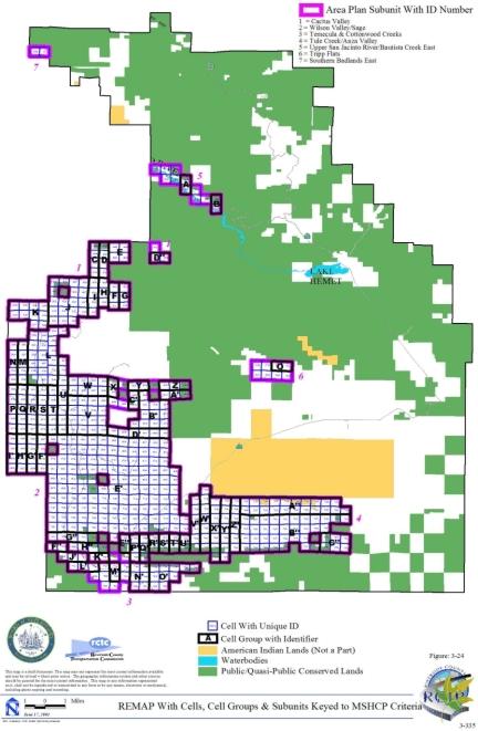
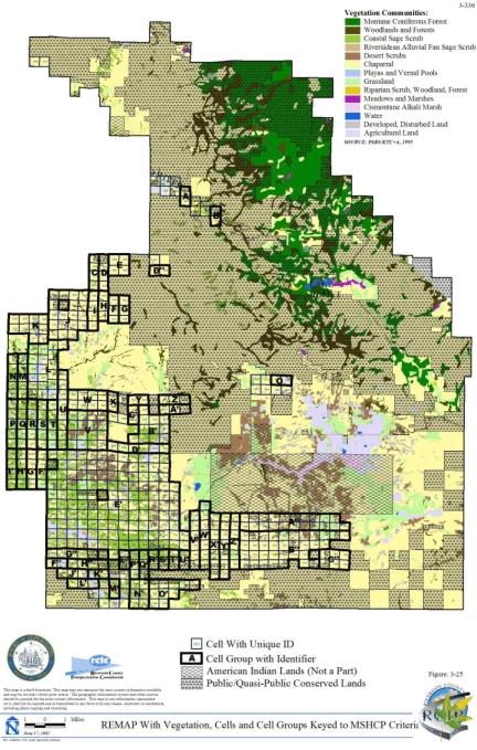
3.3.13 San Jacinto Valley Area Plan
➤ Target Acreages
➤ Applicable Cores and Linkages
➤ Area Plan Subunits
TABLE 3-14
CRITERIA FOR SAN JACINTO VALLEY AREA PLAN
| Sub Unit |
Cell Group | Quadrat Number |
USGS Section |
Quarter Section |
Criteria |
|---|---|---|---|---|---|
| SUBUNIT 1 - Gilman Springs | |||||
| 1 | A | 1495 | 24 | NW | Conservation within this Cell Group will contribute to assembly of Proposed Core 3. Conservation within this Cell Group will focus on chaparral and coastal sage scrub habitat. Areas conserved within this Cell Group will be connected to chaparral and coastal sage scrub habitat proposed for conservation in Cell Group B to the east, in Cell Group H to the south and in Cell Groups F', G' and H' in the Reche Canyon/Badlands Area Plan to the west. Conservation within this Cell Group will range from 50%-60% of the Cell Group focusing in the southern portion of the Cell Group. |
| 1 | A | 1589 | 24 | SW | |
| 1 | A | 1653 | 25 | NW | |
| 1 | B | 1496 | 24 | NE | Conservation within this Cell Group will contribute to assembly of Proposed Core 3. Conservation within this Cell Group will focus on chaparral and coastal sage scrub habitat. Areas conserved within this Cell Group will be connected to chaparral and coastal sage scrub habitat proposed for conservation in Cell Group C to the east and in Cell Groups A and H to the west and to chaparral, coastal sage scrub, grassland, riparian scrub, woodland and forest habitat proposed for conservation in Cell Group I to the south. Conservation within this Cell Group will range from 40%-50% of the Cell Group focusing in the southern portion of the Cell Group. |
| 1 | B | 1590 | 24 | SE | |
| 1 | B | 1687 | 25 | NE | |
| 1 | B | 1784 | 25 | SE | |
| 1 | C | 1497 | 19 | NW | Conservation within this Cell Group will contribute to assembly of Proposed Core 3. Conservation within this Cell Group will focus on chaparral and coastal sage scrub habitat. Areas conserved within this Cell Group will be connected to chaparral and coastal sage scrub habitat proposed for conservation in Cell Groups B to the west, D to the east and J to the south. Conservation within this Cell Group will range from 20%-30% of the Cell Group focusing in the southern portion of the Cell Group. |
| 1 | C | 1591 | 19 | SW | |
| 1 | C | 1688 | 30 | NW | |
| 1 | C | 1785 | 30 | SW | |
| 1 | D | 1498 | 19 | NE | Conservation within this Cell Group will contribute to assembly of Proposed Core 3. Conservation within this Cell Group will focus on chaparral, coastal sage scrub, grassland, riparian scrub, woodland and forest habitat. Areas conserved within this Cell Group will be connected to chaparral and coastal sage scrub habitat proposed for conservation in Cell Group E to the east and in Cell Groups C and J to the west and to chaparral, coastal sage scrub and grassland habitat proposed for conservation in Cell Group K to the south. Conservation within this Cell Group will range from 25%-35% of the Cell Group focusing in the southern portion of the Cell Group. |
| 1 | D | 1592 | 19 | SE | |
| 1 | D | 1692 | 30 | NE | |
| 1 | D | 1793 | 30 | SE | |
| 1 | D | 1893 | 31 | NE | |
| 1 | E | 1598 | 20 | SW | Conservation within this Cell Group will contribute to assembly of Proposed Core 3. Conservation within this Cell Group will focus on chaparral and coastal sage scrub habitat. Areas conserved within this Cell Group will be connected to chaparral and coastal sage scrub habitat proposed for conservation in Cell Group D to the west and to chaparral, coastal sage scrub, riparian scrub, woodland and forest habitat proposed for conservation in Cell Groups F to the east and L to the south. Conservation within this Cell Group will range from 20%-30% of the Cell Group focusing in the southern portion of the Cell Group. |
| 1 | E | 1698 | 29 | NW | |
| 1 | E | 1795 | 29 | SW | |
| 1 | E | 1892 | 32 | NW | |
| 1 | F | 1600 | 20 | SE | Conservation within this Cell Group will contribute to assembly of Proposed Core 3. Conservation within this Cell Group will focus on chaparral, coastal sage scrub, riparian scrub, woodland and forest habitat. Areas conserved within this Cell Group will be connected to chaparral and coastal sage scrub habitat proposed for conservation in Cell Groups E to the west, M to the south, and Cell Group B in the Pass Area Plan to the east, and to chaparral, coastal sage scrub, riparian scrub, woodland and forest habitat proposed for conservation in Cell Group L also to the west and in Cell Group G to the east. Conservation within this Cell Group will range from 30%-40% of the Cell Group focusing in the southern portion of the Cell Group. |
| 1 | F | 1697 | 29 | NE | |
| 1 | F | 1790 | 29 | SE | |
| 1 | F | 1883 | 32 | NE | |
| 1 | F | 1980 | 32 | SE | |
| 1 | G | 1599 | 21 | SE | Conservation within this Cell Group will contribute to assembly of Proposed Core 3. Conservation within this Cell Group will focus on chaparral, coastal sage scrub, riparian scrub, woodland and forest habitat. Areas conserved within this Cell Group will be connected to coastal sage scrub, riparian scrub, woodland and forest habitat proposed for conservation in Cell Group F to the west and to chaparral and coastal sage scrub habitat proposed for conservation in Cell Group B in the Pass Area Plan to the south. Conservation within this Cell Group will be approximately 5% of the Cell Group focusing in the southern portion of the Cell Group. |
| 1 | G | 1696 | 28 | NW | |
| 1 | G | 1791 | 28 | SW | |
| 1 | G | 1884 | 33 | NW | |
| 1 | H | 1763 | 25 | SW | Conservation within this Cell Group will contribute to assembly of Proposed Core 3. Conservation within this Cell Group will focus on chaparral, coastal sage scrub, grassland, riparian scrub, woodland and forest habitat. Areas conserved within this Cell Group will be connected to chaparral and coastal sage scrub habitat proposed for conservation in Cell Group B to the east, to coastal sage scrub and grassland habitat proposed for conservation in Cell Group I also to the east, to coastal sage scrub habitat proposed for conservation in Cell #1762 in the Reche Canyon/Badlands Area Plan to the west, and to grassland habitat proposed for conservation in Cell #1881 in the Reche Canyon/Badlands Area Plan also to the west. Conservation within this Cell Group will range from 25%-35% of the Cell Group focusing in the northern portion of the Cell Group. |
| 1 | H | 1881 | 36 | NW | |
| 1 | H | 1978 | 36 | SW | |
| 1 | H | 2073 | 01 | NW | |
| 1 | H | 2168 | 01 | SW | |
| 1 | I | 1882 | 36 | NE | Conservation within this Cell Group will contribute to assembly of Proposed Core 3. Conservation within this Cell Group will focus on chaparral, coastal sage scrub, grassland, riparian scrub, woodland and forest habitat. Areas conserved within this Cell Group will be connected to chaparral and coastal sage scrub habitat proposed for conservation in Cell Group J to the east and to coastal sage scrub and grassland habitat proposed for conservation in Cell Groups H to the west and B to the north. Conservation within this Cell Group will range from 15%-25% of the Cell Group focusing in the northern portion of the Cell Group. |
| 1 | I | 1979 | 36 | SE | |
| 1 | I | 2075 | 01 | NE | |
| 1 | I | 2169 | 01 | SE | |
| 1 | J | 1885 | 31 | NW | Conservation within this Cell Group will contribute to assembly of Proposed Core 3 and Existing Constrained Linkage C. Conservation within this Cell Group will focus on chaparral, coastal sage scrub and grassland habitat associated with the Badlands and on riparian scrub, woodland and forest habitat associated with the San Jacinto River. Areas conserved within this Cell Group will be connected to chaparral and coastal sage scrub habitat proposed for conservation in Cell Groups I to the west, C to the north, and D to the east, to chaparral, coastal sage scrub, and grassland habitat proposed for conservation in Cell Group K also to the east, and to riparian scrub, woodland and forest habitat also proposed for conservation in Cell Group K to the east. Conservation within this Cell Group will range from 20%-30% of the Cell Group focusing in the northern and southern portions of the Cell Group. |
| 1 | J | 1982 | 31 | SW | |
| 1 | J | 2078 | 06 | NW | |
| 1 | J | 2170 | 06 | SW | |
| 1 | J | 2264 | 07 | NW | |
| 1 | K | 1985 | 31 | SE | Conservation within this Cell Group will contribute to assembly of Proposed Core 3 and Existing Constrained Linkage C. Conservation within this Cell Group will focus on chaparral, coastal sage scrub and grassland habitat associated with the Badlands and on riparian scrub, woodland, and forest habitat associated with the San Jacinto River. Areas conserved within this Cell Group will be connected to chaparral and coastal sage scrub habitat proposed for conservation in Cell Group L to the east, to chaparral, coastal sage scrub, and grassland habitat proposed for conservation in Cell Groups D to the north and J to the west, and to riparian scrub, woodland, and forest habitat also proposed for conservation in Cell Group J to the west. Conservation within this Cell Group will range from 25%-35% of the Cell Group focusing in the northern and southern portions of the Cell Group. |
| 1 | K | 2077 | 06 | NE | |
| 1 | K | 2171 | 06 | SE | |
| 1 | K | 2265 | 07 | NE | |
| 1 | L | 1984 | 32 | SW | Conservation within this Cell Group will contribute to assembly of Proposed Core 3. Conservation within this Cell Group will focus on chaparral, coastal sage scrub, riparian scrub, woodland and forest habitat. Areas conserved within this Cell Group will be connected to chaparral and coastal sage scrub habitat proposed for conservation in Cell Groups K to the west, and F and M to the east and to chaparral, coastal sage scrub, riparian scrub, woodland and forest habitat proposed for conservation in Cell Group E to the north. Conservation within this Cell Group will range from 40%-50% of the Cell Group focusing in the northern portion of the Cell Group. |
| 1 | L | 2076 | 05 | NW | |
| 1 | L | 2172 | 05 | SW | |
| 1 | L | 2266 | 08 | NW | |
| 1 | L | 2363 | 08 | SW | |
| 1 | M | 2074 | 05 | NE | Conservation within this Cell Group will contribute to assembly of Proposed Core 3. Conservation within this Cell Group will focus on chaparral and coastal sage scrub habitat. Areas conserved within this Cell Group will be connected to chaparral and coastal sage scrub habitat proposed for conservation in Cell Groups L to the west, F to the north, O to the east, and in Cell Group B in the Pass Area Plan also to the east. Conservation within this Cell Group will range from 35%-45% of the Cell Group focusing in the northern portion of the Cell Group. |
| 1 | M | 2173 | 05 | SE | |
| 1 | M | 2267 | 08 | NE | |
| 1 | M | 2364 | 08 | SE | |
| 1 | O | 2174 | 04 | SW | Conservation within this Cell Group will contribute to assembly of Proposed Core 3 and Proposed Constrained Linkage 21. Conservation within this Cell Group will focus on chaparral, coastal sage scrub, Riversidean alluvial fan sage scrub, grassland, and water habitat. Areas conserved within this Cell Group will be connected to chaparral and coastal sage scrub habitat proposed for conservation in Cell Groups M to the west and P to the east, to Riversidean alluvial fan sage scrub and grassland habitat proposed for conservation in Cell #2365 to the south, and to chaparral, coastal sage scrub, riparian scrub, woodland and forest habitat proposed for conservation in Cell Group B in the Pass Area Plan to the north. Conservation within this Cell Group will range from 70%-80% of the Cell Group focusing in the southern portion of the Cell Group. |
| 1 | O | 2268 | 09 | NW | |
| 1 | P | 2269 | 09 | NE | Conservation within this Cell Group will contribute to assembly of Proposed Core 3 and Proposed Linkage 11. Conservation within this Cell Group will focus on chaparral, coastal sage scrub, and grassland habitat. Areas conserved within this Cell Group will be connected to chaparral and coastal sage scrub habitat proposed for conservation in Cell Groups O to the west and Q to the east and in Cell #2270 also to the east, and to chaparral, coastal sage scrub, and grassland habitat proposed for conservation in Cell Group B in the Pass Area Plan to the north. Conservation within this Cell Group will range from 70%-80% of the Cell Group focusing in the northern portion of the Cell Group. |
| 1 | P | 2366 | 09 | SE | |
| 1 | Q | 2367 | 10 | SW | Conservation within this Cell Group will contribute to assembly of Proposed Linkage 11. Conservation within this Cell Group will focus on chaparral and coastal sage scrub habitat associated with the Badlands and on habitat along the San Jacinto River. Areas conserved within this Cell Group will be connected to chaparral and coastal sage scrub habitat proposed for conservation in Cell Groups P to the west, R to the east and in Cell #2270 to the north and to Riversidean alluvial fan sage scrub habitat proposed for conservation along the San Jacinto River in Cell #2462 to the west and #2568 to the south. Conservation within this Cell Group will range from 75%-85% of the Cell Group focusing in the northern portion and southwestern corner of the Cell Group. |
| 1 | Q | 2463 | 15 | NW | |
| 1 | R | 2368 | 10 | SE | Conservation within this Cell Group will contribute to assembly of Proposed Linkage 11. Conservation within this Cell Group will focus on chaparral and coastal sage scrub habitat. Areas conserved within this Cell Group will be connected to chaparral and coastal sage scrub habitat proposed for conservation in Cell Group Q to the west, to coastal sage scrub habitat proposed for conservation in Cell #2569 to the south and in Cell Group S to the east, and to chaparral habitat proposed for conservation in Cell Group B in the Pass Area Plan also to the east. Conservation within this Cell Group will range from 65%-75% of the Cell Group focusing in the southern portion of the Cell Group. |
| 1 | R | 2464 | 15 | NE | |
| 1 | S | 2465 | 14 | NW | Conservation within this Cell Group will contribute to assembly of Proposed Linkage 11. Conservation within this Cell Group will focus on chaparral and coastal sage scrub habitat. Areas conserved within this Cell Group will be connected to coastal sage scrub habitat proposed for conservation in Cell Groups R to the west and T to the south, and to chaparral and coastal sage scrub habitat proposed for conservation in Cell #2469 in the Riverside Extended Mountain Area Plan to the east and in Cell Group B in the Pass Area Plan to the north. Conservation within this Cell Group will range from 70%-80% of the Cell Group focusing in the southwestern portion of the Cell Group. |
| 1 | S | 2468 | 14 | NE | |
| 1 | T | 2570 | 14 | SW | Conservation within this Cell Group will contribute to assembly of Proposed Linkage 11 and Proposed Core 5. Conservation within this Cell Group will focus on chaparral, coastal sage scrub and Riversidean alluvial fan sage scrub habitat. Areas conserved within this Cell Group will be connected to chaparral and coastal sage scrub habitat proposed for conservation in Cell Group S to the north, to chaparral habitat proposed for conservation in Cell #2469 in the Riverside Extended Mountain Area Plan also to the north, to coastal sage scrub habitat proposed for conservation in Cell Group W to the south, to coastal sage scrub and Riversidean alluvial fan sage scrub habitat proposed for conservation in Cell #2674 also to the south, and to coastal sage scrub, grassland and Riversidean alluvial fan sage scrub habitat proposed for conservation in Cell #2569 to the west. Conservation within this Cell Group will range from 65%-75% of the Cell Group focusing in the western portion of the Cell Group. |
| 1 | T | 2571 | 14 | SE | |
| 1 | T | 2574 | 13 | SW | |
| 1 | T | 2576 | 13 | SE | |
| 1 | W | 2675 | 23 | NE | Conservation within this Cell Group will contribute to assembly of Proposed Linkage 11 and Proposed Core 5. Conservation within this Cell Group will focus on coastal sage scrub, Riversidean alluvial fan sage scrub, riparian scrub, woodland, and forest habitat. Areas conserved within this Cell Group will be connected to chaparral and coastal sage scrub habitat proposed for conservation in Cell Group T to the north and to coastal sage scrub and Riversidean alluvial fan sage scrub habitat proposed for conservation in Cell #2674 to the west and in Cell #2787 to the south. Conservation within this Cell Group will range from 50%-60% of the Cell Group focusing in the western portion of the Cell Group. |
| 1 | W | 2678 | 24 | NW | |
| 1 | 2270 | 10 | NW | Conservation within this Cell will contribute to assembly of Proposed Linkage 11 and Proposed Core 3. Conservation within this Cell will focus on chaparral and coastal sage scrub habitat. Areas conserved within this Cell will be connected to chaparral, coastal sage scrub, and grassland habitat proposed for conservation in Cell Group P to the west, to chaparral and coastal sage scrub habitat proposed for conservation in Cell Group Q to the south, and to chaparral habitat proposed for conservation in Cell Group B in the Pass Area Plan to the north. Conservation within this Cell will range from 20%-30% of the Cell focusing in the northwestern and southwestern portions of the Cell. | |
| 1 | 2365 | 09 | SW | Conservation within this Cell will contribute to assembly of Proposed Constrained Linkage 21 and Existing Constrained Linkage C. Conservation within this Cell will focus on grassland, Riversidean alluvial fan sage scrub, riparian scrub, woodland and forest habitat associated with the San Jacinto River. Areas conserved within this Cell will be connected to Riversidean alluvial fan sage scrub habitat proposed for conservation in Cell #2461 to the south and to Riversidean alluvial fan sage scrub, chaparral and grassland habitat proposed for conservation in Cell Group O to the north. Conservation within this Cell will range from 55%-65% of the Cell focusing in the western portion of the Cell. | |
| 1 | 2461 | 16 | NW | Conservation within this Cell will contribute to assembly of Existing Constrained Linkage C. Conservation within this Cell will focus on Riversidean alluvial fan sage scrub habitat along the San Jacinto River. Areas conserved within this Cell will be connected to Riversidean alluvial fan sage scrub habitat proposed for conservation in Cell #2462 to the east and to Riversidean alluvial fan sage scrub, riparian scrub, woodland and forest habitat proposed for conservation in Cell #2365 to the north. Conservation within this Cell will range from 5%-15% of the Cell focusing in the northeastern portion of the Cell. | |
| 1 | 2462 | 16 | NE | Conservation within this Cell will contribute to assembly of Existing Constrained Linkage C. Conservation within this Cell will focus on Riversidean alluvial fan sage scrub habitat along the San Jacinto River. Areas conserved within this Cell will be connected to Riversidean alluvial fan sage scrub habitat proposed for conservation in Cell #2461 to the west and to habitat proposed for conservation along the San Jacinto River in Cell Group Q to the east. Conservation within this Cell will range from 15%-25% of the Cell focusing in the central portion of the Cell. | |
| 1 | 2568 | 15 | SW | Conservation within this Cell will contribute to assembly of Proposed Core 5. Conservation within this Cell will focus on Riversidean alluvial fan sage scrub, grassland, riparian scrub, woodland and forest habitat and agricultural land adjacent to the San Jacinto River. Areas conserved within this Cell will be connected to grassland habitat proposed for conservation in Cell #2569 to the east and to habitat proposed for conservation along the San Jacinto River in Cell Group Q to the north. Conservation within this Cell will range from 35%-45% of the Cell focusing in the northern portion of the Cell. | |
| 1 | 2569 | 15 | SE | Conservation within this Cell will contribute to assembly of Proposed Core 5 and Proposed Linkage 11. Conservation within this Cell will focus on Riversidean alluvial fan sage scrub, grassland, coastal sage scrub, riparian scrub, woodland and forest habitat associated with the San Jacinto River. Areas conserved within this Cell will be connected to grassland habitat proposed for conservation in Cell #2568 to the west and to Riversidean alluvial fan sage scrub, coastal sage scrub, chaparral and grassland habitat proposed for conservation in Cell Group T to the east. Conservation within this Cell will range from 35%-45% of the Cell focusing in the central and eastern portions of the Cell. | |
| 1 | 2674 | 23 | NW | Conservation within this Cell will contribute to assembly of Proposed Core 5 and Proposed Linkage 11. Conservation within this Cell will focus on Riversidean alluvial fan sage scrub, coastal sage scrub, grassland, riparian scrub, woodland and forest habitat associated with the San Jacinto River. Areas conserved within this Cell will be connected to coastal sage scrub and Riversidean alluvial fan sage scrub habitat proposed for conservation in Cell Group W to the east and in Cell Group T to the north. Conservation within this Cell will range from 40%-50% of the Cell focusing in the northern portion of the Cell. | |
| 1 | 2787 | 24 | SW | Conservation within this Cell will contribute to assembly of Proposed Linkage 11. Conservation within this Cell will focus on Riversidean alluvial fan sage scrub, chaparral, and coastal sage scrub habitat associated with the San Jacinto River. Areas conserved within this Cell will be connected to coastal sage scrub habitat proposed for conservation in Cell Group W to the north. Conservation within this Cell will range from 45%-55% of the Cell focusing in the northern portion of the Cell. | |
| 1 | 2271 | 10 | NE | No new conservation is anticipated within this Cell. | |
| SUBUNIT 2 - Lakeview Mountains East | |||||
| 2 | A' | 2978 | 26 | SE | Conservation within this Cell Group will contribute to assembly of Proposed Noncontiguous Habitat Block 5. Conservation within this Cell Group will focus on chaparral and coastal sage scrub habitat. Areas conserved within this Cell Group will be connected to chaparral and coastal sage scrub habitat proposed for conservation in Cell Groups Y to the north, B' to the south and in Cell Group L in the Lakeview/Nuevo Area Plan to the west. Conservation within this Cell Group will range from 65%-75% of the Cell Group focusing in the western portion of the Cell Group. |
| 2 | A' | 2979 | 25 | SW | |
| 2 | A' | 2981 | 25 | SE | |
| 2 | B' | 3079 | 35 | NE | Conservation within this Cell Group will contribute to assembly of Proposed Noncontiguous Habitat Block 5. Conservation within this Cell Group will focus on chaparral and coastal sage scrub habitat. Areas conserved within this Cell Group will be connected to chaparral and coastal sage scrub habitat proposed for conservation in Cell Group A' to the north and in Cell Group L in the Lakeview/Nuevo Area Plan to the west and to chaparral habitat proposed for conservation in Cell #3180 to the south. Conservation within this Cell Group will range from 45%-55% of the Cell Group focusing in the western portion of the Cell Group. |
| 2 | B' | 3080 | 36 | NW | |
| 2 | N | 2072 | 02 | NE | Conservation within this Cell Group will contribute to assembly of Proposed Noncontiguous Habitat Block 5. Conservation within this Cell Group will focus on chaparral, coastal sage scrub, and grassland habitat. Areas conserved within this Cell Group will be connected to chaparral and coastal sage scrub habitat proposed for conservation in Cell Group U to the east, to chaparral habitat proposed for conservation in Cell #2663 to the south, and to chaparral, coastal sage scrub, and grassland habitat proposed for conservation in Cell Group L in the Lakeview/Nuevo Area Plan to the west. Conservation within this Cell Group will range from 25%-35% of the Cell Group focusing in the southern portion of the Cell Group. |
| 2 | N | 2167 | 02 | SE | |
| 2 | N | 2261 | 11 | NE | |
| 2 | N | 2358 | 11 | SE | |
| 2 | N | 2454 | 14 | NE | |
| 2 | N | 2559 | 14 | SE | |
| 2 | U | 2560 | 13 | SW | Conservation within this Cell Group will contribute to assembly of Proposed Noncontiguous Habitat Block 5. Conservation within this Cell Group will focus on chaparral and coastal sage scrub habitat. Areas conserved within this Cell Group will be connected to chaparral and coastal sage scrub habitat proposed for conservation in Cell Groups X to the south, N to the west and in Cell #2663 also to the west. Conservation within this Cell Group will range from 55%-65% of the Cell Group focusing in the southwestern portion of the Cell Group. |
| 2 | U | 2664 | 24 | NW | |
| 2 | X | 2769 | 24 | SW | Conservation within this Cell Group will contribute to assembly of Proposed Noncontiguous Habitat Block 5. Conservation within this Cell Group will focus on chaparral and coastal sage scrub habitat. Areas conserved within this Cell Group will be connected to chaparral and coastal sage scrub habitat proposed for conservation in Cell Groups U to the north and Y to the south and to chaparral habitat proposed for conservation in Cell #2768 to the west. Conservation within this Cell Group will range from 60%-70% of the Cell Group focusing in the western portion of the Cell Group. |
| 2 | X | 2770 | 24 | SE | |
| 2 | Y | 2874 | 25 | NW | Conservation within this Cell Group will contribute to assembly of Proposed Noncontiguous Habitat Block 5. Conservation within this Cell Group will focus on chaparral and coastal sage scrub habitat. Areas conserved within this Cell Group will be connected to chaparral and coastal sage scrub habitat proposed for conservation in Cell Groups X to the north and A' to the south. Conservation within this Cell Group will range from 65%-75% of the Cell Group focusing in the western portion of the Cell Group. |
| 2 | Y | 2875 | 25 | NE | |
| 2 | 2663 | 23 | NE | Conservation within this Cell will contribute to assembly of Proposed Noncontiguous Habitat Block 5. Conservation within this Cell will focus on chaparral and coastal sage scrub habitat. Areas conserved within this Cell will be connected to chaparral habitat proposed for conservation in Cell #2768 to the south, in Cell Group N to the north, and in Cell Group L in the Lakeview/Nuevo Area Plan to the west and to chaparral and coastal sage scrub habitat proposed for conservation in Cell Group U to the east. Conservation within this Cell will range from 75%-85% of the Cell focusing in the northeastern portion of the Cell. | |
| 2 | 2768 | 23 | SE | Conservation within this Cell will contribute to assembly of Proposed Noncontiguous Habitat Block 5. Conservation within this Cell will focus on chaparral habitat. Areas conserved within this Cell will be connected to chaparral habitat proposed for conservation in Cell #2663 to the north, in Cell Group X to the east and in Cell Group L in the Lakeview/Nuevo Area Plan to the west. Conservation within this Cell will range from 30%-40% of the Cell focusing in the eastern portion of the Cell. | |
| 2 | 3180 | 35 | SE | Conservation within this Cell will contribute to assembly of Proposed Noncontiguous Habitat Block 5. Conservation within this Cell will focus on chaparral and coastal sage scrub habitat. Areas conserved within this Cell will be connected to chaparral and coastal sage scrub habitat proposed for conservation in Cell #3187 to the west and in Cell Group B' to the north. Conservation within this Cell will range from 15%-25% of the Cell focusing in the northwestern portion of the Cell. | |
| 2 | 3187 | 35 | SW | Conservation within this Cell will contribute to assembly of Proposed Noncontiguous Habitat Block 5. Conservation within this Cell will focus on chaparral and coastal sage scrub habitat. Areas conserved within this Cell will be connected to chaparral and coastal sage scrub habitat proposed for conservation in Cell #3180 to the east and to chaparral habitat proposed for conservation in Cell Group L in the Lakeview/Nuevo Area Plan to the north. Conservation within this Cell will range from 40%-50% of the Cell focusing in the northeastern portion of the Cell. | |
| SUBUNIT 3 - Upper San Jacinto River/Bautista Creek | |||||
| 3 | C' | 3610 | 10 | SW | Conservation within this Cell Group will contribute to assembly of Proposed Core 5. Conservation within this Cell Group will focus on coastal sage scrub, Riversidean alluvial fan sage scrub, riparian scrub, woodland and forest habitat. Areas conserved within this Cell Group will be connected to Riversidean alluvial fan sage scrub habitat proposed for conservation in Cell #3497 to the north and to coastal sage scrub and Riversidean alluvial fan sage scrub habitat proposed for conservation in Cell #3615 to the east. Conservation within this Cell Group will range from 40%-50% of the Cell Group focusing in the northern portion of the Cell Group. |
| 3 | C' | 3614 | 10 | SE | |
| 3 | F' | 4119 | 28 | NW | Conservation within this Cell Group will contribute to assembly of Proposed Core 4. Conservation within this Cell Group will focus on chaparral, grassland, woodland and forest habitat. Areas conserved within this Cell Group will be connected to chaparral and grassland habitat proposed for conservation in Cell Group G' to the east and to chaparral habitat proposed for conservation in Cell Group L' to the west and in Cell Group C in the Riverside Extended Mountain Area Plan to the south. Conservation within this Cell Group will range from 75%-85% of the Cell Group focusing in the southern portion of the Cell Group. |
| 3 | F' | 4222 | 28 | SW | |
| 3 | F' | 4318 | 33 | NW | |
| 3 | F' | 4408 | 33 | SW | |
| 3 | G' | 4120 | 28 | NE | Conservation within this Cell Group will contribute to assembly of Proposed Core 4. Conservation within this Cell Group will focus on chaparral, coastal sage scrub, and grassland habitat. Areas conserved within this Cell Group will be connected to chaparral, grassland, woodland and forest habitat proposed for conservation in Cell Group F' to the west and to chaparral and grassland habitat proposed for conservation in Cell Group K' to the east. Conservation within this Cell Group will range from 70%-80% of the Cell Group focusing in the southern portion of the Cell Group. |
| 3 | G' | 4219 | 28 | SE | |
| 3 | G' | 4311 | 33 | NE | |
| 3 | G' | 4400 | 33 | SE | |
| 3 | H' | 4116 | 27 | NE | Conservation within this Cell Group will contribute to assembly of Proposed Core 4. Conservation within this Cell Group will focus on chaparral, Riversidean alluvial fan sage scrub, and grassland habitat and agricultural land. Areas conserved within this Cell Group will be connected to chaparral habitat proposed for conservation in Cell Group K' to the west and in Cell #4313 to the south and to Riversidean alluvial fan sage scrub habitat and agricultural land proposed for conservation in Cell #4217 to the east. Conservation within this Cell Group will range from 55%-65% of the Cell Group focusing in the southern portion of the Cell Group. |
| 3 | H' | 4216 | 27 | SE | |
| 3 | K' | 4218 | 27 | SW | Conservation within this Cell Group will contribute to assembly of Proposed Core 4. Conservation within this Cell Group will focus on chaparral, grassland, riparian scrub, woodland and forest habitat. Areas conserved within this Cell Group will be connected to chaparral and grassland habitat proposed for conservation in Cell Group G' to the west, to chaparral, riparian scrub, woodland and forest habitat proposed for conservation in Cell Group N' to the east, and to chaparral habitat proposed for conservation in Cell #4313 to the east, in Cell Group H' also to the east, and in Cell Group E in the Riverside Extended Mountain Area Plan to the south. Conservation within this Cell Group will range from 55%-65% of the Cell Group focusing in the southern portion of the Cell Group. |
| 3 | K' | 4312 | 34 | NW | |
| 3 | K' | 4401 | 34 | SW | |
| 3 | M' | 4315 | 35 | NW | Conservation within this Cell Group will contribute to assembly of Proposed Core 4. Conservation within this Cell Group will focus on chaparral and Riversidean alluvial fan sage scrub habitat and agricultural land. Areas conserved within this Cell Group will be connected to Riversidean alluvial fan sage scrub habitat and agricultural land proposed for conservation in Cell #4217 to the north and to chaparral and Riversidean alluvial fan sage scrub habitat proposed for conservation in Cell Group N' to the south. Conservation within this Cell Group will range from 45%-55% of the Cell Group focusing in the central portion of the Cell Group. |
| 3 | M' | 4319 | 35 | NE | |
| 3 | N' | 4405 | 34 | SE | Conservation within this Cell Group will contribute to assembly of Proposed Core 4. Conservation within this Cell Group will focus on chaparral, coastal sage scrub, Riversidean alluvial fan sage scrub, riparian scrub, woodland and forest habitat. Areas conserved within this Cell Group will be connected to chaparral and Riversidean alluvial fan sage scrub habitat and agricultural land proposed for conservation in Cell Group M' to the north, to chaparral, riparian scrub, woodland and forest habitat proposed for conservation in Cell Group K' to the west, and to chaparral habitat proposed for conservation in Cell #4511 in the Riverside Extended Mountain Area Plan to the southeast. Conservation within this Cell Group will range from 55%-65% of the Cell Group focusing in the eastern portion and western edge of the Cell Group. |
| 3 | N' | 4407 | 35 | SW | |
| 3 | N' | 4414 | 35 | SE | |
| 3 | T' | 3414 | 05 | SW | Conservation within this Cell Group will contribute to assembly of Proposed Core 5. Conservation within this Cell Group will focus on Riversidean alluvial fan sage scrub habitat and adjacent habitat expanding existing conserved wetland habitat along the San Jacinto River. Areas conserved within this Cell Group will be connected to Riversidean alluvial fan sage scrub habitat proposed for conservation in Cell Group U' to the east. Conservation within this Cell Group will be approximately 5% of the Cell Group focusing in the northern portion of the Cell Group. |
| 3 | T' | 3611 | 08 | SW | |
| 3 | U' | 3416 | 05 | SE | Conservation within this Cell Group will contribute to assembly of Proposed Core 5. Conservation within this Cell Group will focus on Riversidean alluvial fan sage scrub, coastal sage scrub, and grassland habitat. Areas conserved within this Cell Group will be connected to Riversidean alluvial fan sage scrub habitat proposed for conservation in Cell Group T' to the west and in Cell #3413 to the east. Conservation within this Cell Group will range from 15%-25% of the Cell Group focusing in the northern portion of the Cell Group. |
| 3 | U' | 3613 | 08 | SE | |
| 3 | Z | 2893 | 25 | NW | Conservation within this Cell Group will contribute to assembly of Proposed Core 5. Conservation within this Cell Group will focus on grassland habitat. Areas conserved within this Cell Group will be connected to grassland habitat proposed for conservation in Cell #3098 to the west and #3204 to the south. Conservation within this Cell Group will be approximately 5% of the Cell Group focusing in the southwestern portion of the Cell Group. |
| 3 | Z | 2895 | 25 | NE | |
| 3 | Z | 2996 | 25 | SE | |
| 3 | Z | 3099 | 36 | NE | |
| 3 | 3098 | 36 | NW | Conservation within this Cell will contribute to assembly of Proposed Core 5. Conservation within this Cell will focus on grassland habitat adjacent to the San Jacinto River. Areas conserved within this Cell will be connected to grassland habitat proposed for conservation in Cell Group Z to the east. Conservation within this Cell will range from 5%-15% of the Cell focusing in the southeastern portion of the Cell. | |
| 3 | 3204 | 36 | SE | Conservation within this Cell will contribute to assembly of Proposed Core 5. Conservation within this Cell will focus on grassland habitat adjacent to the San Jacinto River. Areas conserved within this Cell will be connected to grassland habitat proposed for conservation in Cell Group Z to the north and in Cell #3312 to the south. Conservation within this Cell will range from 45%-55% of the Cell focusing in the central portion of the Cell. | |
| 3 | 3312 | 01 | NE | Conservation within this Cell will contribute to assembly of Proposed Core 5. Conservation within this Cell will focus on grassland habitat associated with the San Jacinto River. Areas conserved within this Cell will be connected to grassland habitat proposed for conservation in Cell #3204 to the north and in Cell #3313 to the east. Conservation within this Cell will range from 5%-15% of the Cell focusing in the northeastern portion of the Cell. | |
| 3 | 3313 | 06 | NW | Conservation within this Cell will contribute to assembly of Proposed Core 5. Conservation within this Cell will focus on grassland and coastal sage scrub habitat adjacent to the San Jacinto River. Areas conserved within this Cell will be connected to grassland habitat proposed for conservation in Cell #3312 to the west. Conservation within this Cell will range from 45%-55% of the Cell focusing in the central portion of the Cell. | |
| 3 | 3413 | 04 | SW | Conservation within this Cell will contribute to assembly of Proposed Core 5. Conservation within this Cell will focus on Riversidean alluvial fan sage scrub habitat adjacent to the San Jacinto River. Areas conserved within this Cell will be connected to Riversidean alluvial fan sage scrub habitat proposed for conservation in Cell Group U' to the west and in Cell #3496 to the southeast. Conservation within this Cell will range from 15%-25% of the Cell focusing in the northwestern portion of the Cell. | |
| 3 | 3496 | 09 | NE | Conservation within this Cell will contribute to assembly of Proposed Core 5. Conservation within this Cell will focus on Riversidean alluvial fan sage scrub, grassland, coastal sage scrub, riparian scrub, woodland and forest habitat associated with the San Jacinto River. Areas conserved within this Cell will be connected to Riversidean alluvial fan sage scrub habitat proposed for conservation in Cell #3413 to the northwest and in Cell #3497 to the east. Conservation within this Cell will range from 35%-45% of the Cell focusing in the northeastern portion of the Cell. | |
| 3 | 3497 | 10 | NW | Conservation within this Cell will contribute to assembly of Proposed Core 5. Conservation within this Cell will focus on Riversidean alluvial fan sage scrub habitat associated with the San Jacinto River. Areas conserved within this Cell will be connected to Riversidean alluvial fan sage scrub habitat proposed for conservation in Cell Group C' to the south and in Cell #3496 to the west. Conservation within this Cell will range from 5%-15% of the Cell focusing in the southwestern portion of the Cell. | |
| 3 | 3615 | 11 | SW | Conservation within this Cell will contribute to assembly of Proposed Core 5. Conservation within this Cell will focus on Riversidean alluvial fan sage scrub, coastal sage scrub, chaparral and water habitat adjacent to the San Jacinto River. Areas conserved within this Cell will be connected to Riversidean alluvial fan sage scrub, coastal sage scrub and chaparral habitat proposed for conservation in Cell #3616 to the east, to Riversidean alluvial fan sage scrub and coastal sage scrub habitat proposed for conservation in Cell Group C' to the west, and to water habitat and agricultural land proposed for conservation in Cell #3717 to the south. Conservation within this Cell will range from 40%-50% of the Cell focusing in the southern portion of the Cell. | |
| 3 | 3616 | 11 | SE | Conservation within this Cell will contribute to assembly of Proposed Core 5. Conservation within this Cell will focus on Riversidean alluvial fan sage scrub, coastal sage scrub, chaparral, riparian scrub, woodland, and forest habitat adjacent to the San Jacinto River. Areas conserved within this Cell will be connected to Riversidean alluvial fan sage scrub, coastal sage scrub and chaparral habitat proposed for conservation in Cell #3615 to the west and in Cell #3721 to the south. Conservation within this Cell will range from 5%-15% of the Cell focusing in the southwestern portion of the Cell. | |
| 3 | 3717 | 14 | NW | Conservation within this Cell will contribute to assembly of Proposed Core 5. Conservation within this Cell will focus on water habitat and agricultural land adjacent to the San Jacinto River. Areas conserved within this Cell will be connected to Riversidean alluvial fan sage scrub, coastal sage scrub and water habitat proposed for conservation in Cell #3615 to the north and to coastal sage scrub habitat and agricultural land proposed for conservation in Cell #3721 to the east. Conservation within this Cell will range from 20%-30% of the Cell focusing in the northern portion of the Cell. | |
| 3 | 3721 | 14 | NE | Conservation within this Cell will contribute to assembly of Proposed Core 5. Conservation within this Cell will focus on Riversidean alluvial fan sage scrub, coastal sage scrub, chaparral, riparian scrub, woodland, and forest habitat and agricultural land adjacent to the San Jacinto River. Areas conserved within this Cell will be connected to Riversidean alluvial fan sage scrub, coastal sage scrub and chaparral habitat proposed for conservation in Cell #3616 to the north, to agricultural land proposed for conservation in Cell #3717 to the west, and to chaparral, Riversidean alluvial fan sage scrub, riparian scrub, woodland and forest habitat proposed for conservation in Cell #3723 in the Riverside Extended Mountain Area Plan to the east. Conservation within this Cell will range from 40%-50% of the Cell focusing in the northern portion of the Cell. | |
| 3 | 3912 | 21 | NW | Conservation within this Cell will contribute to assembly of Proposed Core 4. Conservation within this Cell will focus on agricultural land. Areas conserved within this Cell will be connected to agricultural land proposed for conservation in Cell #3914 to the east. Conservation within this Cell will range from 10%-20% of the Cell focusing in the northeastern portion of the Cell. | |
| 3 | 3914 | 21 | NE | Conservation within this Cell will contribute to assembly of Proposed Core 4. Conservation within this Cell will focus on chaparral habitat and agricultural land. Areas conserved within this Cell will be connected to agricultural land proposed for conservation in Cell #3912 to the west and in Cell #4018 to the south. Conservation within this Cell will range from 50%-60% of the Cell focusing in the southwestern portion of the Cell. | |
| 3 | 4018 | 21 | SE | Conservation within this Cell will contribute to assembly of Proposed Core 4. Conservation within this Cell will focus on Riversidean alluvial fan sage scrub and chaparral habitat and agricultural land. Areas conserved within this Cell will be connected to chaparral habitat and agricultural land proposed for conservation in Cell #3914 to the north and in Cell #4019 to the east. Conservation within this Cell will range from 35%-45% of the Cell focusing in the northeastern portion of the Cell. | |
| 3 | 4019 | 22 | SW | Conservation within this Cell will contribute to assembly of Proposed Core 4. Conservation within this Cell will focus on chaparral habitat and agricultural land. Areas conserved within this Cell will be connected to chaparral and Riversidean alluvial fan sage scrub habitat proposed for conservation in Cell #4018 to the west and to chaparral habitat proposed for conservation in Cell #4020 to the east. Conservation within this Cell will range from 30%-40% of the Cell focusing in the southern portion of the Cell. | |
| 3 | 4020 | 22 | SE | Conservation within this Cell will contribute to assembly of Proposed Core 4. Conservation within this Cell will focus on chaparral habitat. Areas conserved within this Cell will be connected to chaparral habitat proposed for conservation in Cell #4019 to the west. Conservation within this Cell will range from 10%-20% of the Cell focusing in the central portion of the Cell. | |
| 3 | 4217 | 26 | SW | Conservation within this Cell will contribute to assembly of Proposed Core 4. Conservation within this Cell will focus on Riversidean alluvial fan sage scrub habitat and agricultural land. Areas conserved within this Cell will be connected to Riversidean alluvial fan sage scrub and chaparral habitat and agricultural land proposed for conservation in Cell Group H' to the west and in Cell Group M' to the south. Conservation within this Cell will range from 45%-55% of the Cell focusing in the southwestern portion of the Cell. | |
| 3 | 4313 | 34 | NE | Conservation within this Cell will contribute to assembly of Proposed Core 4. Conservation within this Cell will focus on chaparral habitat. Areas conserved within this Cell will be connected to chaparral and grassland habitat proposed for conservation in Cell Group H' to the north and to chaparral, riparian scrub, woodland, and forest habitat proposed for conservation in Cell Group K' to the west. Conservation within this Cell will range from 10%-20% of the Cell focusing in the northern portion and western edge of the Cell. | |
| 3 | 3100 | 31 | NW | No new conservation is anticipated within this Cell. | |
| SUBUNIT 4 - Hemet Vernal Pool Areas East | |||||
| 4 | D' | 3584 | 12 | SE | Conservation within this Cell Group will contribute to assembly of Proposed Noncontiguous Habitat Block 7. Conservation within this Cell Group will focus on playas/vernal pool habitat and agricultural land. Areas conserved within this Cell Group will be connected to playas/vernal pool habitat proposed for conservation in Cell #3793 to the east, in Cell #3891 and #3892 to the south and in Cell #3684 and #3791 both in the Harvest Valley/Winchester Area Plan to the west. Conservation within this Cell Group will range from 70%-80% of the Cell Group focusing in the central portion of the Cell Group. |
| 4 | D' | 3684 | 13 | NE | |
| 4 | D' | 3791 | 13 | SW | |
| 4 | D' | 3792 | 13 | SE | |
| 4 | V | 2666 | 19 | NW | Conservation within this Cell Group will contribute to assembly of Proposed Noncontiguous Habitat Block 6. Conservation within this Cell Group will focus on grassland habitat and agricultural land. Conservation within this Cell Group will range from 70%-80% of the Cell Group focusing in the northern portion of the Cell Group. |
| 4 | V | 2774 | 19 | SW | |
| 4 | 2071 | 02 | NW | Conservation within this Cell will contribute to assembly of Proposed Constrained Linkage 20. Conservation within this Cell will focus on playas/vernal pool habitat and agricultural land adjacent to the San Jacinto River. Areas conserved within this Cell will be connected to playas/vernal pool habitat proposed for conservation in Cell #2166 to the south and in Cell #2070 in the Reche Canyon/Badlands Area Plan to the west. Conservation within this Cell will be approximately 5% of the Cell focusing in the southwestern portion of the Cell. | |
| 4 | 2166 | 02 | SW | Conservation within this Cell will contribute to assembly of Proposed Constrained Linkage 20. Conservation within this Cell will focus on playas/vernal pool habitat and agricultural land adjacent to the San Jacinto River. Areas conserved within this Cell will be connected to playas/vernal pool habitat and agricultural land proposed for conservation in Cell #2071 to the north and to water habitat and agricultural land proposed for conservation in Cell Group K in the Lakeview/Nuevo Area Plan to the west. Conservation within this Cell will range from 40%-50% of the Cell focusing in the northwestern portion of the Cell. | |
| 4 | 2775 | 19 | SE | Conservation within this Cell will contribute to assembly of Proposed Noncontiguous Habitat Block 6. Conservation within this Cell will focus on water and riparian scrub, woodland and forest habitat. Areas conserved within this Cell will be connected to water habitat proposed for conservation in Cell #2878 to the south. Conservation within this Cell will range from 30%-40% of the Cell focusing in the southern portion of the Cell. | |
| 4 | 2878 | 30 | NE | Conservation within this Cell will contribute to assembly of Proposed Noncontiguous Habitat Block 6. Conservation within this Cell will focus on water habitat. Areas conserved within this Cell will be connected to water habitat proposed for conservation in Cell #2775 to the north. Conservation within this Cell will range from 10%-20% of the Cell focusing in the northern portion of the Cell. | |
| 4 | 3291 | 06 | NW | Conservation within this Cell Group will contribute to assembly of Proposed Noncontiguous Habitat Block 7. Conservation within this Cell Group will focus on grassland habitat. Conservation within this Cell Group will be approximately 5% of the Cell Group focusing in the western portion of the Cell Group. | |
| 4 | 3793 | 18 | SW | Conservation within this Cell will contribute to assembly of Proposed Noncontiguous Habitat Block 7. Conservation within this Cell will focus on playas/vernal pool habitat. Areas conserved within this Cell will be connected to playas/vernal pool habitat proposed for conservation in Cell Group D' to the west. Conservation within this Cell will range from 55%-65% of the Cell focusing in the central portion of the Cell. | |
| 4 | 3891 | 24 | NW | Conservation within this Cell will contribute to assembly of Proposed Noncontiguous Habitat Block 7. Conservation within this Cell will focus on playas/vernal pool habitat. Areas conserved within this Cell will be connected to playas/vernal pool habitat proposed for conservation in Cell Group D' to the north, in Cell #3892 to the east, in Cell #4007 to the south and in Cell #3891 in the Harvest Valley/Winchester Area Plan to the west. Conservation within this Cell will range from 45%-55% of the Cell focusing in the eastern portion of the Cell. | |
| 4 | 3892 | 24 | NE | Conservation within this Cell will contribute to assembly of Proposed Noncontiguous Habitat Block 7. Conservation within this Cell will focus on playas/vernal pool habitat and agricultural land. Areas conserved within this Cell will be connected to playas/vernal pool habitat proposed for conservation in Cell Group D' to the north and in Cell #3891 to the west. Conservation within this Cell will range from 75%-85% of the Cell focusing in the northwestern portion of the Cell. | |
| 4 | 4007 | 24 | SW | Conservation within this Cell will contribute to assembly of Proposed Noncontiguous Habitat Block 7. Conservation within this Cell will focus on playas/vernal pool habitat. Areas conserved within this Cell will be connected to playas/vernal pool habitat proposed for conservation in Cell #3891 to the north and in Cell #4007 in the Harvest Valley/Winchester Area Plan to the west. Conservation within this Cell will be approximately 5% of the Cell focusing in the northern portion of the Cell. | |
| SUBUNIT 5 - Mica Butte | |||||
| 5 | E' | 4100 | 30 | NE | Conservation within this Cell Group will contribute to assembly of Proposed Core 4. Conservation within this Cell Group will focus on chaparral, coastal sage scrub, grassland, Riversidean alluvial fan sage scrub, woodland and forest habitat. Areas conserved within this Cell Group will be connected to chaparral, coastal sage scrub, grassland and Riversidean alluvial fan sage scrub habitat proposed for conservation in Cell Group I' to the west, to chaparral, coastal sage scrub, grassland, Riversidean alluvial fan sage scrub, woodland and forest habitat proposed for conservation in Cell Groups J' to the east, and to chaparral and coastal sage scrub habitat proposed for conservation in Cell Group J in the Riverside Extended Mountain Area Plan to the south. Conservation within this Cell Group will range from 45%-55% of the Cell Group focusing in the southern portion of the Cell Group. |
| 5 | E' | 4199 | 30 | SE | |
| 5 | E' | 4299 | 31 | NE | |
| 5 | E' | 4396 | 31 | SE | |
| 5 | E' | 4496 | 06 | NE | |
| 5 | E' | 4541 | 06 | SE | |
| 5 | E' | 4633 | 07 | NE | |
| 5 | E' | 4730 | 07 | SE | |
| 5 | I' | 4195 | 30 | SW | Conservation within this Cell Group will contribute to assembly of Proposed Core 4. Conservation within this Cell Group will focus on chaparral, coastal sage scrub, grassland, Riversidean alluvial fan sage scrub, woodland and forest habitat. Areas conserved within this Cell Group will be connected to chaparral, coastal sage scrub, grassland, and Riversidean alluvial fan sage scrub habitat proposed for conservation in Cell Group E' to the east, to chaparral, grassland, Riversidean alluvial fan sage scrub, woodland and forest habitat proposed for conservation in Cell Group O' to the west, and to chaparral habitat proposed for conservation in Cell Group J in the Riverside Extended Mountain Area Plan to the south. Conservation within this Cell Group will range from 50%-60% of the Cell Group focusing in the southern portion of the Cell Group. |
| 5 | I' | 4285 | 31 | NW | |
| 5 | I' | 4389 | 31 | SW | |
| 5 | I' | 4499 | 06 | NW | |
| 5 | I' | 4543 | 06 | SW | |
| 5 | I' | 4635 | 07 | NW | |
| 5 | I' | 4728 | 07 | SW | |
| 5 | J' | 4211 | 29 | SW | Conservation within this Cell Group will contribute to assembly of Proposed Core 4. Conservation within this Cell Group will focus on chaparral, coastal sage scrub, grassland, Riversidean alluvial fan sage scrub, woodland and forest habitat. Areas conserved within this Cell Group will be connected to chaparral, coastal sage scrub, grassland, woodland and forest habitat proposed for conservation in Cell Group L' to the east, to chaparral, coastal sage scrub, grassland, and Riversidean alluvial fan sage scrub habitat proposed for conservation in Cell Group E' to the west, and to chaparral habitat proposed for conservation in Cell Group J in the Riverside Extended Mountain Area Plan to the south. Conservation within this Cell Group will range from 45%-55% of the Cell Group focusing in the southern portion of the Cell Group. |
| 5 | J' | 4305 | 32 | NW | |
| 5 | J' | 4402 | 32 | SW | |
| 5 | J' | 4497 | 05 | NW | |
| 5 | J' | 4542 | 05 | SW | |
| 5 | J' | 4634 | 08 | NW | |
| 5 | J' | 4731 | 08 | SW | |
| 5 | L' | 4215 | 29 | SE | Conservation within this Cell Group will contribute to assembly of Proposed Core 4. Conservation within this Cell Group will focus on chaparral, coastal sage scrub, grassland, woodland and forest habitat. Areas conserved within this Cell Group will be connected to chaparral and grassland habitat proposed for conservation in Cell Group F' to the east, to chaparral habitat proposed for conservation in Cell Group C in the Riverside Extended Mountain Area Plan also to the east, to chaparral, coastal sage scrub, grassland, woodland and forest habitat proposed for conservation in Cell Group J' to the west, and to chaparral, coastal sage scrub, woodland and forest habitat proposed for conservation in Cell Group J in the Riverside Extended Mountain Area Plan to the south. Conservation within this Cell Group will range from 70%-80% of the Cell Group focusing in the southern portion of the Cell Group. |
| 5 | L' | 4317 | 32 | NE | |
| 5 | L' | 4409 | 32 | SE | |
| 5 | L' | 4503 | 05 | NE | |
| 5 | L' | 4545 | 05 | SE | |
| 5 | L' | 4636 | 08 | NE | |
| 5 | L' | 4732 | 08 | SE | |
| 5 | O' | 4502 | 01 | NE | Conservation within this Cell Group will contribute to assembly of Proposed Linkage 14. Conservation within this Cell Group will focus on chaparral, coastal sage scrub, grassland, Riversidean alluvial fan sage scrub, woodland and forest habitat. Areas conserved within this Cell Group will be connected to chaparral, coastal sage scrub, and grassland habitat proposed for conservation in Cell Group P' to the west, to chaparral and coastal sage scrub habitat proposed for conservation in Cell Group S' to the south, to chaparral, coastal sage scrub, grassland, Riversidean alluvial fan sage scrub, woodland, and forest habitat proposed for conservation in Cell Group I' to the east, and to chaparral, woodland and forest habitat proposed for conservation in Cell Group J in the Riverside Extended Mountain Area Plan also to the east. Conservation within this Cell Group will range from 45%-55% of the Cell Group focusing in the southern portion of the Cell Group. |
| 5 | O' | 4602 | 01 | SE | |
| 5 | O' | 4700 | 12 | NE | |
| 5 | O' | 4801 | 12 | SE | |
| 5 | O' | 4888 | 13 | NE | |
| 5 | P' | 4697 | 12 | NW | Conservation within this Cell Group will contribute to assembly of Proposed Linkage 14. Conservation within this Cell Group will focus on chaparral, coastal sage scrub, grassland, riparian scrub, woodland and forest habitat. Areas conserved within this Cell Group will be connected to chaparral, coastal sage scrub, grassland, woodland and forest habitat proposed for conservation in Cell Group O' to the east, to chaparral and grassland habitat proposed for conservation in Cell Group Q' to the west, and to chaparral, riparian scrub, woodland, and forest habitat proposed for conservation in Cell Group S' to the south. Conservation within this Cell Group will range from 55%-65% of the Cell Group focusing in the southern portion of the Cell Group. |
| 5 | P' | 4797 | 12 | SW | |
| 5 | P' | 4889 | 13 | NW | |
| 5 | Q' | 4796 | 11 | SE | Conservation within this Cell Group will contribute to assembly of Proposed Linkage 14. Conservation within this Cell Group will focus on chaparral and grassland habitat. Areas conserved within this Cell Group will be connected to chaparral, grassland, riparian scrub, woodland and forest habitat proposed for conservation in Cell Group P' to the east and to chaparral habitat proposed for conservation in Cell Group R' to the west and S' to the south. Conservation within this Cell Group will range from 55%-65% of the Cell Group focusing in the southern portion of the Cell Group. |
| 5 | Q' | 4893 | 14 | NE | |
| 5 | R' | 4887 | 15 | NW | Conservation within this Cell Group will contribute to assembly of Proposed Linkage 14. Conservation within this Cell Group will focus on chaparral, coastal sage scrub, grassland, riparian scrub, woodland and forest habitat. Areas conserved within this Cell Group will be connected to chaparral, grassland, riparian scrub, woodland and forest habitat proposed for conservation in Cell Group S' to the south and to chaparral and grassland habitat proposed for conservation in Cell Group Q' to the east. Conservation within this Cell Group will range from 75%-85% of the Cell Group focusing in the eastern portion of the Cell Group. |
| 5 | R' | 4890 | 15 | NE | |
| 5 | R' | 4894 | 14 | NW | |
| 5 | S' | 4987 | 15 | SW | Conservation within this Cell Group will contribute to assembly of Proposed Linkage 14. Conservation within this Cell Group will focus on chaparral, coastal sage scrub, grassland, Riversidean alluvial fan sage scrub, riparian scrub, woodland and forest habitat. Areas conserved within this Cell Group will be connected to chaparral, grassland, riparian scrub, woodland and forest habitat proposed for conservation in Cell Group R' to the north and in Cell Group K in the Riverside Extended Mountain Area Plan to the south, to chaparral and grassland habitat proposed for conservation in Cell Group Q' to the north, to chaparral, riparian scrub, woodland, and forest habitat proposed for conservation in Cell Group P' to the north, to chaparral and coastal sage scrub habitat proposed for conservation in Cell Group O' to the north, and to chaparral habitat proposed for conservation in Cell Group J in the Riverside Extended Mountain Area Plan to the east and in Cell Group K in the Southwest Area Plan also to the south. Conservation within this Cell Group will range from 75%-85% of the Cell Group focusing in the eastern portion of the Cell Group. |
| 5 | S' | 4989 | 15 | SE | |
| 5 | S' | 4990 | 14 | SE | |
| 5 | S' | 4991 | 13 | SW | |
| 5 | S' | 4992 | 14 | SW | |
| 5 | S' | 4994 | 13 | SE | |
| 5 | 4896 | 16 | NW | Conservation within this Cell will contribute to assembly of Existing Core J. Conservation within this Cell will focus on chaparral and coastal sage scrub habitat connecting existing conserved habitat. Conservation within this Cell will range from 40%-50% of the Cell focusing in the eastern portion of the Cell. | |
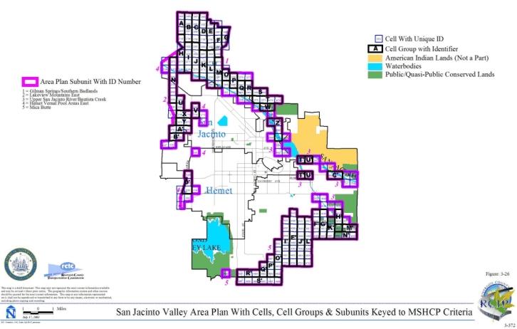
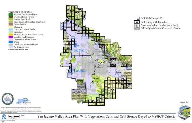
3.3.14 Sun City/Menifee Area Plan
➤ Target Acreages
➤ Applicable Cores and Linkages
➤ Area Plan Subunits
TABLE 3-15
CRITERIA FOR SUN CITY/MENIFEE AREA PLAN
| Sub Unit |
Cell Group | Quadrat Number |
USGS Section |
Quarter Section |
Criteria |
|---|---|---|---|---|---|
| SUBUNIT 1 - Warm Springs Creek/French Valley Area | |||||
| 1 | A | 5066 | 24 | NE | Conservation within this Cell Group will contribute to assembly of Proposed Linkage 8. Conservation within this Cell Group will focus on grassland and coastal sage scrub. Areas conserved within this Cell Group will be connected to uplands proposed for conservation in Cell Group B to the east, and to upland habitat proposed for conservation in Cell Group X to the south in the Southwest Area Plan. Conservation within this Cell Group will range from 50%-60% focusing on the southern and central portions of the Cell Group. |
| 1 | A | 5163 | 24 | SW | |
| 1 | A | 5165 | 24 | SE | |
| 1 | B | 5167 | 19 | SW | Conservation within this Cell Group will contribute to assembly of Proposed Constrained Linkage 17. Conservation within this Cell Group will focus on grassland and coastal sage scrub. Areas conserved within this Cell Group will be connected to grassland habitat proposed for conservation in Cell Group A to the west, to agricultural land proposed for conservation to the east in Cell #5174 in the Southwest Area Plan, and to uplands proposed for conservation in Cell Group X to the south in the Southwest Area Plan. Conservation within this Cell Group will range from 60%-70% focusing on the western and the northeastern portions of the Cell Group. |
| 1 | B | 5168 | 19 | SE | |
| SUBUNIT 2 - Lower Sedco Hills | |||||
| 2 | C | 5252 | 28 | NW | Conservation within this Cell Group will contribute to assembly of Proposed Linkage 8 and Proposed Constrained Linkage 16. Conservation within this Cell Group will focus on chaparral, woodlands and forest, a small area of coastal sage scrub, and grassland. Areas conserved within this Cell Group will be connected to coastal sage scrub and chaparral habitat proposed for conservation to the south in Cell Groups H and I, and Cell #5460 all in the Southwest Area Plan. Conservation within this Cell Group will range from 60%-70% focusing on the southern, central and eastern portions of the Cell Group. |
| 2 | C | 5253 | 28 | NE | |
| 2 | C | 5254 | 27 | NW | |
| 2 | C | 5255 | 27 | NE | |
| 2 | C | 5355 | 28 | SW | |
| 2 | C | 5356 | 28 | SE | |
| 2 | C | 5357 | 27 | SW | |
| 2 | C | 5358 | 27 | SE | |
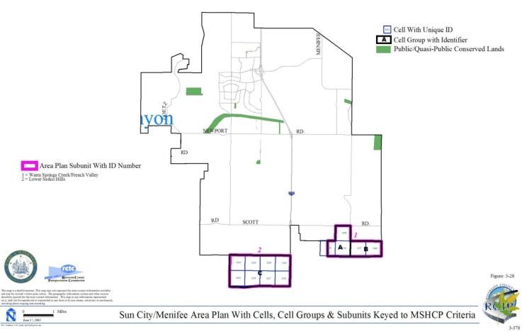
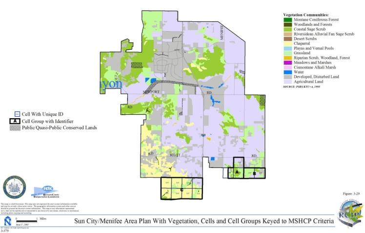
3.3.15 Southwest Area Plan
➤ Target Acreages
➤ Applicable Cores and Linkages
➤ Area Plan Subunits
TABLE 3-16
CRITERIA FOR SOUTHWEST AREA PLAN
| Sub Unit |
Cell Group | Quadrat Number |
USGS Section |
Quarter Section |
Criteria |
|---|---|---|---|---|---|
| SUBUNIT 1 - Murrieta Creek | |||||
| 1 | 5983 | 12 | SW | Conservation within this Cell will contribute to assembly of Proposed Constrained Linkage 13. Conservation within this Cell will focus on chaparral habitat adjacent to Murrieta Creek. Areas conserved within this Cell will be connected to chaparral habitat proposed for conservation in Cell #5988 to the west and #6100 to the south. Conservation within this Cell will be approximately 5% of the Cell focusing in the southwestern portion of the Cell. | |
| 1 | 5988 | 11 | SE | Conservation within this Cell will contribute to assembly of Proposed Constrained Linkage 13. Conservation within this Cell will focus on chaparral and coastal sage scrub habitat adjacent to Murrieta Creek. Areas conserved within this Cell will be connected to chaparral habitat proposed for conservation in Cell #5983 to the east. Conservation within this Cell will range from 25%-35% of the Cell focusing in the southern portion of the Cell. | |
| 1 | 6095 | 18 | NW | Conservation within this Cell will contribute to assembly of Proposed Constrained Linkage 13. Conservation within this Cell will focus on Riversidean alluvial fan sage scrub habitat along Murrieta Creek and adjacent grassland habitat. Areas conserved within this Cell will be connected to Riversidean alluvial fan sage scrub habitat and agricultural land proposed for conservation in Cell #6207 to the south and to grassland and Riversidean alluvial fan sage scrub habitat proposed for conservation in Cell #6098 to the west. Conservation within this Cell will range from 5%-15% of the Cell focusing in the southern portion of the Cell. | |
| 1 | 6098 | 13 | NE | Conservation within this Cell will contribute to assembly of Proposed Constrained Linkage 13. Conservation within this Cell will focus on chaparral, coastal sage scrub, grassland, Riversidean alluvial fan sage scrub, riparian scrub, woodland and forest habitat adjacent to Murrieta Creek. Areas conserved within this Cell will be connected to chaparral, grassland, riparian scrub, woodland and forest habitat proposed for conservation in Cell #6100 to the west, to chaparral and grassland habitat proposed for conservation in Cell #6209 to the south, and to grassland and Riversidean alluvial fan sage scrub habitat proposed for conservation in Cell #6095 to the east. Conservation within this Cell will range from 35%-45% of the Cell focusing in the southwestern and central portions of the Cell. | |
| 1 | 6100 | 13 | NW | Conservation within this Cell will contribute to assembly of Proposed Constrained Linkage 13. Conservation within this Cell will focus on chaparral, grassland, riparian scrub, woodland and forest habitat adjacent to Murrieta Creek. Areas conserved within this Cell will be connected to chaparral habitat proposed for conservation in Cell #5983 to the north, to chaparral, grassland, riparian scrub, woodland and forest habitat proposed for conservation in Cell #6098 to the east, and to chaparral, riparian scrub, woodland and forest habitat proposed for conservation in Cell #6212 to the south. Conservation within this Cell will range from 40%-50% of the Cell focusing in the southwestern portion of the Cell. | |
| 1 | 6205 | 18 | SE | Conservation within this Cell will contribute to assembly of Proposed Constrained Linkage 13. Conservation within this Cell will focus on Riversidean alluvial fan sage scrub, woodland and forest habitat along Murrieta Creek and adjacent grassland habitat and agricultural land. Areas conserved within this Cell will be connected to Riversidean alluvial fan sage scrub, woodland and forest habitat and agricultural land proposed for conservation in Cell #6207 to the west and to existing Public/Quasi-Public land in Cell #6314 to the southeast. Conservation within this Cell will range from 25%-35% of the Cell focusing in the southwestern portion of the Cell. | |
| 1 | 6207 | 18 | SW | Conservation within this Cell will contribute to assembly of Proposed Constrained Linkage 13. Conservation within this Cell will focus on Riversidean alluvial fan sage scrub, woodland and forest habitat along Murrieta Creek and adjacent agricultural land. Areas conserved within this Cell will be connected to Riversidean alluvial fan sage scrub and adjacent habitat proposed for conservation along Murrieta Creek in Cell #6095 to the north and to Riversidean alluvial fan sage scrub habitat and agricultural land proposed for conservation in Cell #6205 to the east. Conservation within this Cell will range from 10%-20% of the Cell focusing in the northeastern portion of the Cell. | |
| 1 | 6209 | 13 | SE | Conservation within this Cell will contribute to assembly of Proposed Constrained Linkage 13. Conservation within this Cell will focus on chaparral and grassland habitat adjacent to Murrieta Creek. Areas conserved within this Cell will be connected to chaparral and grassland habitat proposed for conservation in Cell #6098 to the north and #6326 to the south. Conservation within this Cell will range from 15%-25% of the Cell focusing in the western portion of the Cell. | |
| 1 | 6212 | 13 | SW | Conservation within this Cell will contribute to assembly of Proposed Constrained Linkage 13. Conservation within this Cell will focus on chaparral, riparian scrub, woodland and forest habitat adjacent to Murrieta Creek. Areas conserved within this Cell will be connected to chaparral, riparian scrub, woodland and forest habitat proposed for conservation in Cell #6100 to the north. Conservation within this Cell will range from 5%-15% of the Cell focusing in the northwestern portion of the Cell. | |
| 1 | 6311 | 20 | NE | Conservation within this Cell will contribute to assembly of Proposed Constrained Linkage 13. Conservation within this Cell will focus on Riversidean alluvial fan sage scrub habitat along Murrieta Creek. Areas conserved within this Cell will be connected to Riversidean alluvial fan sage scrub habitat proposed for conservation in Cell #6314 to the west and #6424 to the south. Conservation within this Cell will be approximately 5% of the Cell focusing in the southwestern portion of the Cell. | |
| 1 | 6314 | 20 | NW | Conservation within this Cell will contribute to assembly of Proposed Constrained Linkage 13. Conservation within this Cell will focus on Riversidean alluvial fan sage scrub habitat along Murrieta Creek and adjacent grassland habitat. Areas conserved within this Cell will be connected to Riversidean alluvial fan sage scrub habitat proposed for conservation in Cell #6311 to the east and to existing Public/Quasi-Public land in Cell #6205 to the northwest. Conservation within this Cell will range from 10%-20% of the Cell focusing in the northeastern portion of the Cell. | |
| 1 | 6326 | 24 | NE | Conservation within this Cell will contribute to assembly of Proposed Constrained Linkage 13. Conservation within this Cell will focus on chaparral and grassland habitat and agricultural land adjacent to Murrieta Creek. Areas conserved within this Cell will be connected to grassland habitat proposed for conservation in Cell #6209 to the north and #6433 to the southeast. Conservation within this Cell will range from 10%-20% of the Cell focusing in the eastern portion of the Cell. | |
| 1 | 6416 | 21 | SE | Conservation within this Cell will contribute to assembly of Proposed Constrained Linkage 13. Conservation within this Cell will focus on the existing Murrieta Creek channel and adjacent grassland habitat and agricultural land to the extent feasible. Areas conserved within this Cell will be connected to agricultural land proposed for conservation in Cell #6422 to the west and #6530 to the south. Conservation within this Cell will range from 15%-25% of the Cell focusing in the southwestern portion of the Cell. | |
| 1 | 6422 | 21 | SW | Conservation within this Cell will contribute to assembly of Proposed Constrained Linkage 13. Conservation within this Cell will focus on the existing Murrieta Creek channel and adjacent grassland and Riversidean alluvial fan sage scrub habitat and agricultural land to the extent feasible. Areas conserved within this Cell will be connected to agricultural land proposed for conservation in Cell #6416 to the east and #6424 to the west. Conservation within this Cell will range from 25%-35% of the Cell focusing in the central portion of the Cell. | |
| 1 | 6424 | 20 | SE | Conservation within this Cell will contribute to assembly of Proposed Constrained Linkage 13. Conservation within this Cell will focus on the existing Murrieta Creek channel and adjacent Riversidean alluvial fan sage scrub habitat and agricultural land to the extent feasible. Areas conserved within this Cell will be connected to agricultural land and Riversidean alluvial fan sage scrub proposed for conservation in Cell #6422 to the east and to Riversidean alluvial fan sage scrub habitat proposed for conservation in Cell #6311 to the north. Conservation within this Cell will range from 20%-30% of the Cell focusing in the northeastern portion of the Cell. | |
| 1 | 6433 | 19 | SW | Conservation within this Cell will contribute to assembly of Proposed Constrained Linkage 13. Conservation within this Cell will focus on chaparral and grassland habitat adjacent to Murrieta Creek. Areas conserved within this Cell will be connected to grassland habitat proposed for conservation in Cell #6326 to the northwest. Conservation within this Cell will range from 5%-15% of the Cell focusing in the northwestern portion of the Cell. | |
| 1 | 6528 | 27 | NW | Conservation within this Cell will contribute to assembly of Proposed Constrained Linkage 13. Conservation within this Cell will focus on grassland habitat along Murrieta Creek to the extent feasible. Areas conserved within this Cell will be connected to habitat proposed for conservation along Murrieta Creek in Cell #6530 to the west and #6656 to the south. Conservation within this Cell will be approximately 5% of the Cell focusing in the western portion of the Cell. | |
| 1 | 6530 | 28 | NE | Conservation within this Cell will contribute to assembly of Proposed Constrained Linkage 13. Conservation within this Cell will focus on the existing Murrieta Creek channel and adjacent grassland habitat and agricultural land to the extent feasible. Areas conserved within this Cell will be connected to agricultural land proposed for conservation in Cell #6416 to the north and to habitat proposed for conservation in Cell #6528 to the east. Conservation within this Cell will range from 30%-40% of the Cell focusing in the northeastern portion of the Cell. | |
| 1 | 6656 | 27 | SW | Conservation within this Cell will contribute to assembly of Proposed Constrained Linkage 13. Conservation within this Cell will focus on the existing Murrieta Creek channel and adjacent grassland habitat and agricultural land to the extent feasible. Areas conserved within this Cell will be connected to habitat proposed for conservation in Cell #6528 to the north and to grassland habitat proposed for conservation in Cell #6782 to the southeast. Conservation within this Cell will range from 5%-15% of the Cell focusing in the southwestern portion of the Cell. | |
| 1 | 6782 | 34 | NE | Conservation within this Cell will contribute to assembly of Proposed Constrained Linkage 13. Conservation within this Cell will focus on the existing Murrieta Creek channel and adjacent grassland habitat to the extent feasible. Areas conserved within this Cell will be connected to habitat proposed for conservation in Cell #6656 to the northwest and to grassland and adjacent habitat proposed for conservation in Cell #6783 to the east. Conservation within this Cell be approximately 5% of the Cell focusing in the northeastern portion of the Cell. | |
| 1 | 6783 | 35 | NW | Conservation within this Cell will contribute to assembly of Proposed Constrained Linkage 13. Conservation within this Cell will focus on the existing Murrieta Creek channel and adjacent riparian scrub, woodland, forest and grassland habitat to the extent feasible. Areas conserved within this Cell will be connected to grassland and adjacent habitat proposed for conservation in Cell #6782 to the west and to riparian scrub, woodland and forest habitat proposed for conservation in Cell #6890 to the south. Conservation within this Cell will be approximately 5% of the Cell focusing in the southwestern portion of the Cell. | |
| 1 | 6890 | 35 | SW | Conservation within this Cell will contribute to assembly of Proposed Constrained Linkage 13. Conservation within this Cell will focus on riparian scrub, woodland, forest, and Riversidean alluvial fan sage scrub habitat along Murrieta Creek. Areas conserved within this Cell will be connected to riparian scrub, woodland and forest habitat proposed for conservation in Cell #6783 to the north and to Riversidean alluvial fan sage scrub, riparian scrub, woodland and forest habitat proposed for conservation in Cell #6891 to the east. Conservation within this Cell will range from 10%-20% of the Cell focusing in the northeastern portion of the Cell. | |
| 1 | 6891 | 35 | SE | Conservation within this Cell will contribute to assembly of Proposed Constrained Linkage 13. Conservation within this Cell will focus on riparian scrub, woodland, forest, Riversidean alluvial fan sage scrub and grassland habitat along Murrieta Creek. Areas conserved within this Cell will be connected to Riversidean alluvial fan sage scrub, riparian scrub, woodland and forest habitat proposed for conservation in Cell #6890 to the west and to riparian scrub, woodland and forest habitat proposed for conservation in Cell #7021 to the south. Conservation within this Cell will range from 15%-25% of the Cell focusing in the southwestern portion of the Cell. | |
| 1 | 7021 | 2 | E | Conservation within this Cell will contribute to assembly of Proposed Constrained Linkage 13. Conservation within this Cell will focus on riparian scrub, woodland and forest habitat along Murrieta Creek. Areas conserved within this Cell will be connected to riparian scrub, woodland and forest habitat proposed for conservation in Cell #6891 to the north and in Cell #7078 to the south. Conservation within this Cell will range from 20%-30% of the Cell focusing in the eastern portion of the Cell. | |
| 1 | 7078 | 11 | NE | Conservation within this Cell will contribute to assembly of Proposed Constrained Linkage 13. Conservation within this Cell will focus on riparian scrub, woodland and forest habitat along Murrieta Creek. Areas conserved within this Cell will be connected to riparian scrub, woodland and forest habitat proposed for conservation in Cell #7021 to the north and in Cell #7079 to the east. Conservation within this Cell will range from 15%-25% of the Cell focusing in the northeastern portion of the Cell. | |
| 1 | 7079 | 12 | NW | Conservation within this Cell will contribute to assembly of Proposed Constrained Linkage 13. Conservation within this Cell will focus on riparian scrub, woodland and forest habitat along Murrieta Creek. Areas conserved within this Cell will be connected to riparian scrub, woodland and forest habitat proposed for conservation in Cell #7078 to the west and to grassland, riparian scrub, woodland and forest habitat proposed for conservation in Cell #7166 to the south. Conservation within this Cell will range from 5%-15% of the Cell focusing in the southwestern portion of the Cell. | |
| 1 | 7166 | 12 | SW | Conservation within this Cell will contribute to assembly of Proposed Constrained Linkage 13 and Proposed Linkage 10. Conservation within this Cell will focus on riparian scrub, woodland, forest and grassland habitat along Murrieta Creek and on additional chaparral habitat within the Cell. Areas conserved within this Cell will be connected to riparian scrub, woodland and forest habitat proposed for conservation in Cell #7079 to the north, to chaparral, grassland, riparian scrub, woodland and forest habitat proposed for conservation in Cell #7264 to the south and to chaparral habitat proposed for conservation in Cell #7164 to the west. Conservation within this Cell will range from 35%-45% of the Cell focusing in the southwestern portion of the Cell. | |
| 1 | 7264 | 13 | NW | Conservation within this Cell will contribute to assembly of Proposed Constrained Linkage 13 and Proposed Linkage 10. Conservation within this Cell will focus on riparian scrub, woodland, forest, grassland and coastal sage scrub habitat along Murrieta Creek and on additional chaparral, grassland and coastal sage scrub habitat within the Cell. Areas conserved within this Cell will be connected to grassland, riparian scrub, woodland, forest and chaparral habitat proposed for conservation in Cell #7166 to the north and to chaparral and coastal sage scrub habitat proposed for conservation in Cell #7258 to the west and Cell #7355 to the south. Conservation within this Cell will range from 70%-80% of the Cell focusing in the western portion and eastern edge of the Cell. | |
| 1 | 7355 | 13 | SW | Conservation within this Cell will contribute to assembly of Proposed Linkage 10. Conservation within this Cell will focus on chaparral, woodland, forest, and coastal sage scrub habitat. Areas conserved within this Cell will be connected to chaparral and coastal sage scrub habitat proposed for conservation in Cell #7264 to the north and Cell #7356 to the east. Conservation within this Cell will range from 40%-50% of the Cell focusing in the northeastern portion of the Cell. | |
| 1 | 7356 | 13 | SE | Conservation within this Cell will contribute to assembly of Proposed Linkage 10 and Proposed Constrained Linkage 14. Conservation within this Cell will focus on chaparral and coastal sage scrub habitat and on riparian scrub, woodland, and forest habitat along Temecula Creek. Areas conserved within this Cell will be connected to chaparral and coastal sage scrub habitat proposed for conservation in Cell #7355 to the west and to riparian scrub, woodland and forest habitat proposed for conservation in Cell #7357 to the east. Conservation within this Cell will range from 50%-60% of the Cell focusing in the western and southeastern portions of the Cell. | |
| SUBUNIT 2 - Temecula and Pechanga Creeks | |||||
| 2 | 7134 | 07 | NW | Conservation within this Cell will contribute to assembly of Proposed Constrained Linkage 24. Conservation within this Cell will focus on Riversidean alluvial fan sage scrub and grassland habitat along Temecula Creek. Areas conserved within this Cell will be connected to Riversidean alluvial fan sage scrub habitat proposed for conservation in Cell #7185 to the west and in Cell Group C to the northeast. Conservation within this Cell will range from 35%-45% of the Cell focusing in the northwestern portion of the Cell. | |
| 2 | 7182 | 11 | SW | Conservation within this Cell will contribute to assembly of Proposed Constrained Linkage 24. Conservation within this Cell will focus on Riversidean alluvial fan sage scrub, riparian scrub, woodland and forest habitat along Temecula Creek. Areas conserved within this Cell will be connected to Riversidean alluvial fan sage scrub, riparian scrub, woodland and forest habitat proposed for conservation in Cell #7275 to the south and in Cell #7183 to the east. Conservation within this Cell will range from 5%-15% of the Cell focusing in the southeastern portion of the Cell. | |
| 2 | 7183 | 11 | SE | Conservation within this Cell will contribute to assembly of Proposed Constrained Linkage 24. Conservation within this Cell will focus on Riversidean alluvial fan sage scrub, riparian scrub, woodland, forest and grassland habitat along Temecula Creek. Areas conserved within this Cell will be connected to Riversidean alluvial fan sage scrub, riparian scrub, woodland and forest habitat proposed for conservation in Cell #7182 to the west and in Cell #7184 to the east. Conservation within this Cell will range from 25%-35% of the Cell focusing in the southern portion of the Cell. | |
| 2 | 7184 | 12 | SW | Conservation within this Cell will contribute to assembly of Proposed Constrained Linkage 24. Conservation within this Cell will focus on Riversidean alluvial fan sage scrub, riparian scrub, woodland, forest and grassland habitat along Temecula Creek. Areas conserved within this Cell will be connected to Riversidean alluvial fan sage scrub, riparian scrub, woodland and forest habitat proposed for conservation in Cell #7183 to the west and to habitat proposed for conservation in Cell #7185 to the east. Conservation within this Cell will range from 30%-40% of the Cell focusing in the southern portion of the Cell. | |
| 2 | 7185 | 12 | SE | Conservation within this Cell will contribute to assembly of Proposed Constrained Linkage 24. Conservation within this Cell will focus on Riversidean alluvial fan sage scrub habitat along Temecula Creek. Areas conserved within this Cell will be connected to habitat proposed for conservation in Cell #7184 to the west and to Riversidean alluvial fan sage scrub habitat proposed for conservation in Cell #7134 to the east. Conservation within this Cell will range from 20%-30% of the Cell focusing in the southern portion of the Cell. | |
| 2 | 7273 | 15 | NW | Conservation within this Cell will contribute to assembly of Proposed Constrained Linkage 24. Conservation within this Cell will focus on riparian scrub, woodland, forest and Riversidean alluvial fan sage scrub habitat along Temecula Creek and adjacent grassland habitat. Areas conserved within this Cell will be connected to Riversidean alluvial fan sage scrub, riparian scrub, woodland, forest and grassland habitat proposed for conservation in Cell #7274 to the east. Conservation within this Cell will range from 5%-15% of the Cell focusing in the eastern central portion of the Cell. | |
| 2 | 7274 | 15 | NE | Conservation within this Cell will contribute to assembly of Proposed Constrained Linkage 24. Conservation within this Cell will focus on riparian scrub, woodland, and forest habitat along Temecula Creek and adjacent Riversidean alluvial fan sage scrub, grassland and chaparral habitat. Areas conserved within this Cell will be connected to Riversidean alluvial fan sage scrub, riparian scrub, woodland, forest and grassland habitat proposed for conservation in Cell #7273 to the west and to riparian scrub, woodland, forest and chaparral habitat proposed for conservation in Cell #7275 to the east. Conservation within this Cell will range from 15%-25% of the Cell focusing in the central portion of the Cell. | |
| 2 | 7275 | 14 | NW | Conservation within this Cell will contribute to assembly of Proposed Constrained Linkage 24. Conservation within this Cell will focus on riparian scrub, woodland, and forest habitat along Temecula Creek and adjacent Riversidean alluvial fan sage scrub and chaparral habitat. Areas conserved within this Cell will be connected to riparian scrub, woodland, forest, grassland and chaparral habitat proposed for conservation in Cell #7274 to the west and to riparian scrub, woodland, forest and grassland habitat proposed for conservation in Cell #7182 to the north. Conservation within this Cell will range from 15%-25% of the Cell focusing in the northwestern portion of the Cell. | |
| 2 | 7357 | 18 | SW | Conservation within this Cell will contribute to assembly of Proposed Constrained Linkage 14. Conservation within this Cell will focus on riparian scrub, woodland, and forest habitat along Temecula Creek. Areas conserved within this Cell will be connected to riparian scrub, woodland and forest habitat proposed for conservation in Cell #7356 to the west, in Cell #7358 to the east, and in Cell #7444 to the south. Conservation within this Cell will range from 10%-20% of the Cell focusing in the southern portion of the Cell. | |
| 2 | 7358 | 18 | SE | Conservation within this Cell will contribute to assembly of Proposed Constrained Linkage 14. Conservation within this Cell will focus on riparian scrub, woodland, forest and grassland habitat along Temecula Creek. Areas conserved within this Cell will be connected to riparian scrub, woodland and forest habitat proposed for conservation in Cell #7357 to the west and in Cell #7445 to the south and to grassland habitat proposed for conservation in Cell #7359 to the east. Conservation within this Cell will range from 5%-15% of the Cell focusing in the southern portion of the Cell. | |
| 2 | 7359 | 17 | SW | Conservation within this Cell will contribute to assembly of Proposed Constrained Linkage 14. Conservation within this Cell will focus on riparian scrub, woodland, forest and grassland habitat along Temecula Creek. Areas conserved within this Cell will be connected to riparian scrub, woodland and forest habitat proposed for conservation in Cell #7446 to the south and to grassland habitat proposed for conservation in Cell #7358 to the west. Conservation within this Cell will range from 5%-15% of the Cell focusing in the southern portion of the Cell. | |
| 2 | 7444 | 19 | NW | Conservation within this Cell will contribute to assembly of Proposed Constrained Linkage 14. Conservation within this Cell will focus on riparian scrub, woodland, and forest habitat along Temecula Creek and also along Pechanga Creek. Areas conserved within this Cell will be connected to riparian scrub, woodland and forest habitat proposed for conservation in Cell #7357 to the north, in Cell #7445 to the east, and in Cell #7520 to the south. Conservation within this Cell will range from 15%-25% of the Cell focusing in the northern and eastern portions of the Cell. | |
| 2 | 7445 | 19 | NE | Conservation within this Cell will contribute to assembly of Proposed Constrained Linkage 14. Conservation within this Cell will focus on riparian scrub, woodland, forest and grassland habitat along Temecula Creek. Areas conserved within this Cell will be connected to riparian scrub, woodland and forest habitat proposed for conservation in Cell #7444 to the west and #7446 to the east, and to riparian scrub, woodland, forest, and grassland habitat proposed for conservation in Cell #7358 to the north. Conservation within this Cell will range from 10%-20% of the Cell focusing in the northern portion of the Cell. | |
| 2 | 7446 | 20 | NW | Conservation within this Cell will contribute to assembly of Proposed Constrained Linkage 14. Conservation within this Cell will focus on riparian scrub, woodland, forest and grassland habitat along Temecula Creek. Areas conserved within this Cell will be connected to riparian scrub, woodland, forest, and grassland habitat proposed for conservation in Cell #7359 to the north and in Cell #7445 to the west. Conservation within this Cell will range from 10%-20% of the Cell focusing in the northern portion of the Cell. | |
| 2 | 7520 | 19 | SW | Conservation within this Cell will contribute to assembly of Proposed Constrained Linkage 14. Conservation within this Cell will focus on riparian scrub, woodland, and forest habitat along Pechanga Creek and adjacent chaparral, coastal sage scrub, woodland and forest habitat. Areas conserved within this Cell will be connected to riparian scrub, woodland and forest habitat proposed for conservation in Cell #7444 to the north and to riparian scrub, woodland, forest, and coastal sage scrub habitat proposed for conservation in Cell #7530 to the east. Conservation within this Cell will range from 5%-15% of the Cell focusing in the northeastern portion of the Cell. | |
| 2 | 7530 | 19 | SE | Conservation within this Cell will contribute to assembly of Proposed Constrained Linkage 14. Conservation within this Cell will focus on riparian scrub, woodland, forest and Riversidean alluvial fan sage scrub habitat along Pechanga Creek and adjacent grassland, coastal sage scrub, woodland and forest habitat. Areas conserved within this Cell will be connected to riparian scrub, woodland, forest and coastal sage scrub habitat proposed for conservation in Cell #7520 to the west and to riparian scrub, woodland, forest, and grassland habitat proposed for conservation in Cell #7592 to the south. Conservation within this Cell will range from 10%-20% of the Cell focusing in the southwestern portion of the Cell. | |
| 2 | 7592 | 30 | NE | Conservation within this Cell will contribute to assembly of Proposed Constrained Linkage 14. Conservation within this Cell will focus on riparian scrub, woodland and forest habitat along Pechanga Creek and adjacent chaparral, grassland, woodland and forest habitat. Areas conserved within this Cell will be connected to riparian scrub, woodland, forest, grassland and Riversidean alluvial fan sage scrub habitat proposed for conservation in Cell #7530 to the north and to riparian scrub, woodland, forest, and chaparral habitat proposed for conservation in Cell #7612 to the east. Conservation within this Cell will range from 35%-45% of the Cell focusing in the northeastern portion of the Cell. | |
| 2 | 7612 | 29 | NW | Conservation within this Cell will contribute to assembly of Proposed Constrained Linkage 14. Conservation within this Cell will focus on Riversidean alluvial fan sage scrub, riparian scrub, woodland and forest habitat along Pechanga Creek and adjacent chaparral, woodland and forest habitat. Areas conserved within this Cell will be connected to riparian scrub, woodland, forest and chaparral habitat proposed for conservation in Cell #7592 to the west and to chaparral habitat proposed for conservation in Cell #7693 to the south. Conservation within this Cell will range from 35%-45% of the Cell focusing in the western portion of the Cell. | |
| 2 | 7693 | 29 | SW | Conservation within this Cell will contribute to assembly of Proposed Constrained Linkage 14. Conservation within this Cell will focus on chaparral, woodland and forest habitat. Areas conserved within this Cell will be connected to chaparral, woodland and forest habitat proposed for conservation in Cell #7612 to the north. Conservation within this Cell will range from 15%-25% of the Cell focusing in the northwestern portion of the Cell. | |
| SUBUNIT 3 - Vail Lake | |||||
| 3 | B | 6373 | 22 | SW | Conservation within this Cell Group will contribute to assembly of Proposed Core 7. Conservation within this Cell Group will focus on chaparral, coastal sage scrub, grassland, woodland and forest habitat. Areas conserved within this Cell Group will be connected to existing Public/Quasi-Public land in Cell Groups C to the west and D to the south and to chaparral and coastal sage scrub habitat proposed for conservation in Cell Group I' in the REMAP Area Plan to the east. Conservation within this Cell Group will range from 40%-50% of the Cell Group focusing in the southwestern and southeastern portions of the Cell Group. |
| 3 | B | 6374 | 22 | SE | |
| 3 | B | 6482 | 27 | NE | |
| 3 | B | 6484 | 27 | NW | |
| 3 | B | 6588 | 28 | SW | |
| 3 | B | 6589 | 28 | SE | |
| 3 | B | 6590 | 27 | SE | |
| 3 | B | 6592 | 27 | SW | |
| 3 | B | 6696 | 33 | NW | |
| 3 | B | 6697 | 33 | NE | |
| 3 | B | 6698 | 34 | NE | |
| 3 | B | 6803 | 33 | SE | |
| 3 | B | 6805 | 33 | SW | |
| 3 | C | 6694 | 32 | NW | Conservation within this Cell Group will contribute to assembly of Proposed Core 7 and Proposed Constrained Linkage 24. Conservation within this Cell Group will focus on Riversidean alluvial fan sage scrub, riparian scrub, woodland and forest habitat along Temecula Creek and adjacent chaparral, coastal sage scrub, grassland, woodland and forest habitat. Areas conserved within this Cell Group will be connected to chaparral, coastal sage scrub, riparian scrub, woodland and forest habitat proposed for conservation in Cell Group D to the southeast and to Riversidean alluvial fan sage scrub habitat proposed for conservation in Cell #7134 to the southwest. Conservation within this Cell Group will range from 60%-70% of the Cell Group focusing in the southern and central portions of the Cell Group. |
| 3 | C | 6695 | 32 | NE | |
| 3 | C | 6807 | 31 | SE | |
| 3 | C | 6808 | 32 | SW | |
| 3 | C | 6809 | 32 | SE | |
| 3 | C | 6911 | 05 | NE | |
| 3 | C | 6913 | 05 | NW | |
| 3 | C | 6917 | 06 | NE | |
| 3 | C | 7010 | 05 | SE | |
| 3 | C | 7012 | 05 | SW | |
| 3 | C | 7014 | 06 | SE | |
| 3 | D | 6894 | 03 | NE | Conservation within this Cell Group will contribute to assembly of Proposed Core 7. Conservation within this Cell Group will focus on water habitat associated with Vail Lake and surrounding habitat including chaparral, coastal sage scrub, grassland, Riversidean alluvial fan sage scrub, riparian scrub, woodland and forest. Areas conserved within this Cell Group will be connected to chaparral, coastal sage scrub, riparian scrub, woodland and forest habitat proposed for conservation in Cell Group C to the northwest and to upland habitat proposed for conservation in Cell Groups F', G', H', and I' in the REMAP Area Plan to the north and in Cell Groups E', F" and G" in the REMAP Area Plan to the east. Conservation within this Cell Group will range from 75%-85% of the Cell Group focusing in the central portion of the Cell Group. |
| 3 | D | 6895 | 02 | NW | |
| 3 | D | 6896 | 03 | NW | |
| 3 | D | 6899 | 02 | NE | |
| 3 | D | 6901 | 01 | NW | |
| 3 | D | 6903 | 01 | NE | |
| 3 | D | 6909 | 04 | NW | |
| 3 | D | 6975 | 01 | SE | |
| 3 | D | 6979 | 01 | SW | |
| 3 | D | 6984 | 02 | SE | |
| 3 | D | 6985 | 02 | SW | |
| 3 | D | 6986 | 03 | SE | |
| 3 | D | 6989 | 03 | SW | |
| 3 | D | 6992 | 04 | SE | |
| 3 | D | 7001 | 04 | SW | |
| 3 | D | 7093 | 12 | NE | |
| 3 | D | 7099 | 12 | NW | |
| 3 | D | 7102 | 11 | NE | |
| 3 | D | 7107 | 11 | NW | |
| 3 | D | 7109 | 10 | NE | |
| 3 | D | 7117 | 10 | NW | |
| 3 | D | 7119 | 09 | NE | |
| 3 | D | 7122 | 09 | NW | |
| 3 | D | 7126 | 08 | NE | |
| 3 | D | 7128 | 08 | NW | |
| 3 | D | 7186 | 12 | SE | |
| 3 | D | 7188 | 12 | SW | |
| 3 | D | 7190 | 11 | SE | |
| 3 | D | 7191 | 11 | SW | |
| 3 | D | 7193 | 10 | SE | |
| 3 | D | 7194 | 10 | SW | |
| 3 | D | 7198 | 09 | SE | |
| 3 | D | 7199 | 09 | SW | |
| 3 | D | 7202 | 08 | SE | |
| 3 | D | 7203 | 08 | SW | |
| 3 | D | 7281 | 17 | NW | |
| 3 | D | 7282 | 17 | NE | |
| 3 | D | 7283 | 16 | NW | |
| 3 | D | 7284 | 16 | NE | |
| 3 | D | 7285 | 15 | NW | |
| 3 | D | 7286 | 15 | NE | |
| 3 | D | 7287 | 14 | NW | |
| 3 | D | 7288 | 14 | NE | |
| 3 | D | 7289 | 13 | NW | |
| 3 | D | 7290 | 13 | NE | |
| 3 | D | 7372 | 17 | SE | |
| 3 | D | 7373 | 16 | SW | |
| 3 | D | 7374 | 16 | SE | |
| 3 | D | 7375 | 15 | SW | |
| 3 | D | 7376 | 15 | SE | |
| 3 | D | 7377 | 14 | SW | |
| 3 | D | 7378 | 14 | SE | |
| 3 | D | 7379 | 13 | SW | |
| 3 | D | 7380 | 13 | SE | |
| 3 | D | 7458 | 20 | NW | |
| 3 | D | 7459 | 20 | NE | |
| 3 | D | 7460 | 21 | NW | |
| 3 | D | 7461 | 21 | NE | |
| 3 | D | 7462 | 22 | NW | |
| 3 | D | 7463 | 22 | NE | |
| 3 | D | 7464 | 23 | NW | |
| 3 | D | 7465 | 23 | NE | |
| 3 | D | 7466 | 24 | NW | |
| 3 | D | 7467 | 24 | NE | |
| 3 | D | 7543 | 20 | SW | |
| 3 | D | 7544 | 20 | SE | |
| 3 | D | 7547 | 22 | SW | |
| 3 | D | 7551 | 24 | SW | |
| 3 | D | 7552 | 24 | SE | |
| 3 | D | 7626 | 29 | NE | |
| 3 | D | 7627 | 28 | NW | |
| 3 | D | 7628 | 28 | NE | |
| SUBUNIT 4 - Cactus Valley/SWRC-MSR/Johnson Ranch | |||||
| 4 | E | 6189 | 14 | SW | Conservation within this Cell Group will contribute to assembly of Proposed Extension of Existing Core 6. Conservation within this Cell Group will focus on agricultural land. Areas conserved within this Cell Group will be connected to grassland habitat proposed for conservation in Cell Group G to the north and to agricultural land proposed for conservation in Cell Group F to the east. Conservation within this Cell Group will range from 30%-40% of the Cell Group focusing in the northern portion of the Cell Group. |
| 4 | E | 6293 | 23 | NW | |
| 4 | E | 6395 | 23 | SW | |
| 4 | F | 6186 | 14 | SE | Conservation within this Cell Group will contribute to assembly of Proposed Extension of Existing Core 6. Conservation within this Cell Group will focus on agricultural land and coastal sage scrub, grassland, woodland and forest habitat. Areas conserved within this Cell Group will be connected to grassland habitat proposed for conservation in Cell Group H to the north and to agricultural land proposed for conservation in Cell Group E to the west. Conservation within this Cell Group will range from 40%-50% of the Cell Group focusing in the northern portion of the Cell Group. |
| 4 | F | 6290 | 23 | NE | |
| 4 | G | 5985 | 11 | SW | Conservation within this Cell Group will contribute to assembly of Proposed Extension of Existing Core 6. Conservation within this Cell Group will focus on grassland and coastal sage scrub habitat. Areas conserved within this Cell Group will be connected to grassland habitat proposed for conservation in Cell Group H to the east and to agricultural land proposed for conservation in Cell Group E to the south. Conservation within this Cell Group will range from 70%-80% of the Cell Group focusing in the southern portion of the Cell Group. |
| 4 | G | 6084 | 14 | NW | |
| 4 | H | 5989 | 11 | SE | Conservation within this Cell Group will contribute to assembly of Proposed Extension of Existing Core 6. Conservation within this Cell Group will focus on grassland and coastal sage scrub habitat. Areas conserved within this Cell Group will be connected to grassland habitat proposed for conservation in Cell Groups G to the west and I to the east and to agricultural land proposed for conservation in Cell Group F to the south. Conservation within this Cell Group will range from 70%-80% of the Cell Group focusing in the southern portion of the Cell Group. |
| 4 | H | 6082 | 14 | NE | |
| 4 | I | 5991 | 12 | SW | Conservation within this Cell Group will contribute to assembly of Proposed Extension of Existing Core 6. Conservation within this Cell Group will focus on grassland and coastal sage scrub habitat. Areas conserved within this Cell Group will be connected to grassland habitat proposed for conservation in Cell Group H to the west and to grassland and coastal sage scrub habitat proposed for conservation in Cell #5992 and #6088 both to the east. Conservation within this Cell Group will range from 70%-80% of the Cell Group focusing in the southern portion of the Cell Group. |
| 4 | I | 6083 | 13 | NW | |
| 4 | K | 4986 | 16 | SE | Conservation within this Cell Group will contribute to assembly of Proposed Linkage 14. Conservation within this Cell Group will focus on chaparral, grassland, coastal sage scrub, woodland and forest habitat. Areas conserved within this Cell Group will be connected to chaparral habitat proposed for conservation in Cell Group S' in the San Jacinto Area Plan to the north and to chaparral and grassland habitat proposed for conservation in Cell Group K in the Riverside Extended Mountain Area Plan to the east. Conservation within this Cell Group will range from 50%-60% of the Cell Group focusing in the southern portion of the Cell Group. |
| 4 | K | 4993 | 16 | SW | |
| 4 | K | 5086 | 22 | NE | |
| 4 | K | 5087 | 22 | NW | |
| 4 | K | 5088 | 21 | NE | |
| 4 | K | 5093 | 21 | NW | |
| 4 | K | 5187 | 22 | SE | |
| 4 | K | 5191 | 22 | SW | |
| 4 | K | 5193 | 21 | SE | |
| 4 | K | 5195 | 21 | SW | |
| 4 | L | 5497 | 34 | NE | Conservation within this Cell Group will contribute to assembly of Proposed Linkage 13. Conservation within this Cell Group will focus on grassland, coastal sage scrub and chaparral habitat. Areas conserved within this Cell Group will be connected to grassland habitat proposed for conservation in Cell Group N to the west, to chaparral, coastal sage scrub and grassland habitat proposed for conservation in Cell Group M to the south, and to chaparral and coastal sage scrub habitat proposed for conservation in Cell Group N in the Riverside Extended Mountain Area Plan to the east. Conservation within this Cell Group will range from 20%-30% of the Cell Group focusing in the southern portion of the Cell Group. |
| 4 | L | 5599 | 34 | SE | |
| 4 | L | 5694 | 03 | NE | |
| 4 | M | 5746 | 03 | SE | Conservation within this Cell Group will contribute to assembly of Proposed Linkage 13. Conservation within this Cell Group will focus on grassland, coastal sage scrub and chaparral habitat. Areas conserved within this Cell Group will be connected to chaparral, coastal sage scrub and grassland habitat proposed for conservation in Cell Groups N to the west and L to the north, and to chaparral and coastal sage scrub habitat proposed for conservation in Cell Group N in the Riverside Extended Mountain Area Plan to the east. Conservation within this Cell Group will range from 55%-65% of the Cell Group focusing in the northern and southeastern portions of the Cell Group. |
| 4 | M | 5843 | 10 | NE | |
| 4 | N | 5593 | 34 | SW | Conservation within this Cell Group will contribute to assembly of Proposed Linkage 13. Conservation within this Cell Group will focus on chaparral, coastal sage scrub and grassland habitat. Areas conserved within this Cell Group will be connected to chaparral and coastal sage scrub habitat proposed for conservation in Cell Groups O to the west and M to the east, to grassland and chaparral habitat proposed for conservation in Cell Group L also to the east, and to coastal sage scrub and grassland habitat proposed for conservation in Cell #5842 to the south. Conservation within this Cell Group will range from 10%-20% of the Cell Group focusing in the southern portion of the Cell Group. |
| 4 | N | 5693 | 03 | NW | |
| 4 | N | 5745 | 03 | SW | |
| 4 | O | 5592 | 33 | SE | Conservation within this Cell Group will contribute to assembly of Proposed Linkage 13. Conservation within this Cell Group will focus on chaparral, coastal sage scrub, grassland, woodland and forest habitat. Areas conserved within this Cell Group will be connected to chaparral and coastal sage scrub habitat proposed for conservation in Cell Group P to the west, to coastal sage scrub habitat proposed for conservation in Cell #5841 to the south, and to chaparral, coastal sage scrub and grassland habitat proposed for conservation in Cell Group N to the east. Conservation within this Cell Group will range from 15%-25% of the Cell Group focusing in the southern portion of the Cell Group. |
| 4 | O | 5692 | 04 | NE | |
| 4 | O | 5744 | 04 | SE | |
| 4 | P | 5590 | 33 | SW | Conservation within this Cell Group will contribute to assembly of Proposed Linkage 13. Conservation within this Cell Group will focus on chaparral, coastal sage scrub, woodland and forest habitat. Areas conserved within this Cell Group will be connected to chaparral habitat proposed for conservation in Cell Group Q and in Cell #5741 both to the west, to coastal sage scrub habitat proposed for conservation in Cell #5840 to the south, and to chaparral and coastal sage scrub habitat proposed for conservation in Cell Group O to the east. Conservation within this Cell Group will range from 25%-35% of the Cell Group focusing in the southern portion of the Cell Group. |
| 4 | P | 5691 | 04 | NW | |
| 4 | P | 5743 | 04 | SW | |
| 4 | Q | 5486 | 31 | NE | Conservation within this Cell Group will contribute to assembly of Proposed Linkage 13. Conservation within this Cell Group will focus on chaparral habitat. Areas conserved within this Cell Group will be connected to chaparral habitat proposed for conservation in Cell Group P to the east and in Cell #5741 to the south. Conservation within this Cell Group will be approximately 5% of the Cell Group focusing in the southeastern portion of the Cell Group. |
| 4 | Q | 5487 | 32 | NW | |
| 4 | Q | 5489 | 32 | NE | |
| 4 | Q | 5583 | 32 | SW | |
| 4 | Q | 5584 | 32 | SE | |
| 4 | Q | 5688 | 05 | NW | |
| 4 | Q | 5689 | 05 | NE | |
| 4 | R | 5284 | 25 | NE | Conservation within this Cell Group will contribute to assembly of Proposed Extension of Existing Core 7. Conservation within this Cell Group will focus on chaparral, coastal sage scrub, grassland, riparian scrub, woodland and forest habitat. Areas conserved within this Cell Group will be connected to chaparral, coastal sage scrub and grassland habitat proposed for conservation in Cell Group S to the west. Conservation within this Cell Group will range from 75%-85% of the Cell Group focusing in the western and northern portions of the Cell Group. |
| 4 | R | 5375 | 25 | SW | |
| 4 | R | 5382 | 25 | SE | |
| 4 | S | 5068 | 22 | NW | Conservation within this Cell Group will contribute to assembly of Proposed Extension of Existing Core 7, Proposed Constrained Linkage 17 and Proposed Constrained Linkage 18. Conservation within this Cell Group will focus on chaparral, coastal sage scrub, grassland, riparian scrub, woodland and forest habitat. Areas conserved within this Cell Group will be connected to habitat proposed for conservation in Cell #5372 to the west, to chaparral habitat proposed for conservation in Cell Group U also to the west, to coastal sage scrub and grassland habitat proposed for conservation in Cell #5169 also to the west and in Cell Group T to the south, to coastal sage scrub habitat proposed for conservation in Cell Group R to the east and to chaparral and coastal sage scrub habitat proposed for conservation in Cell #5177 also to the east. Conservation within this Cell Group will range from 65%-75% of the Cell Group focusing in the eastern portion of the Cell Group. |
| 4 | S | 5071 | 22 | NE | |
| 4 | S | 5076 | 23 | NW | |
| 4 | S | 5077 | 23 | NE | |
| 4 | S | 5170 | 22 | SW | |
| 4 | S | 5172 | 22 | SE | |
| 4 | S | 5176 | 23 | SE | |
| 4 | S | 5178 | 23 | SW | |
| 4 | S | 5271 | 26 | NE | |
| 4 | S | 5273 | 26 | NW | |
| 4 | S | 5274 | 27 | NE | |
| 4 | S | 5278 | 27 | NW | |
| 4 | S | 5373 | 27 | SW | |
| 4 | S | 5374 | 26 | SE | |
| 4 | S | 5379 | 27 | SE | |
| 4 | S | 5381 | 26 | SW | |
| 4 | S | 5471 | 34 | NW | |
| 4 | S | 5478 | 34 | NE | |
| 4 | S | 5481 | 35 | NE | |
| 4 | S | 5484 | 35 | NW | |
| 4 | T | 5567 | 34 | SW | Conservation within this Cell Group will contribute to assembly of Proposed Extension of Existing Core 7. Conservation within this Cell Group will focus on coastal sage scrub and grassland habitat. Areas conserved within this Cell Group will be connected to coastal sage scrub and grassland habitat proposed for conservation in Cell Group S to the north. Conservation within this Cell Group will range from 35%-45% of the Cell Group focusing in the northern portion of the Cell Group. |
| 4 | T | 5574 | 34 | SE | |
| 4 | 5078 | 24 | NW | Conservation within this Cell will contribute to assembly of Proposed Extension of Existing Core 7. Conservation within this Cell will focus on chaparral, coastal sage scrub and grassland habitat. Areas conserved within this Cell will be connected to chaparral and coastal sage scrub habitat proposed for conservation in Cell #5177 to the south. Conservation within this Cell will range from 20%-30% of the Cell focusing in the southeastern portion of the Cell. | |
| 4 | 5177 | 24 | SW | Conservation within this Cell will contribute to assembly of Proposed Extension of Existing Core 7. Conservation within this Cell will focus on chaparral and coastal sage scrub habitat. Areas conserved within this Cell will be connected to chaparral and coastal sage scrub habitat proposed for conservation in Cell #5078 to the north and to chaparral and grassland habitat proposed for conservation in Cell Group S to the west. Conservation within this Cell will range from 30%-40% of the Cell focusing in the northern portion of the Cell. | |
| 4 | 5685 | 01 | NE | Conservation within this Cell will contribute to assembly of Existing Core J. Conservation within this Cell will focus on meadow, marsh, riparian scrub, woodland, forest and chaparral habitat associated with Tucalota Creek and on coastal sage scrub and grassland habitat. Areas conserved within this Cell will be connected to meadow, marsh, riparian scrub, woodland and forest habitat proposed for conservation in Cell #5686 to the east and to riparian scrub, woodland and forest habitat proposed for conservation in Cell #5738 also to the east. Conservation within this Cell will range from 5%-15% of the Cell focusing in the southeastern portion of the Cell. | |
| 4 | 5686 | 06 | NW | Conservation within this Cell will contribute to assembly of Existing Core J. Conservation within this Cell will focus on meadow, marsh, riparian scrub, woodland, forest and coastal sage scrub habitat associated with Tucalota Creek. Areas conserved within this Cell will be connected to meadow, marsh, riparian scrub, woodland and forest habitat proposed for conservation in Cell #5685 to the west and to riparian scrub, woodland, forest and coastal sage scrub habitat proposed for conservation in Cell #5738 to the south. Conservation within this Cell will range from 10%-20% of the Cell focusing in the western portion of the Cell. | |
| 4 | 5738 | 06 | SW | Conservation within this Cell will contribute to assembly of Existing Core J. Conservation within this Cell will focus on riparian scrub, woodland, forest and coastal sage scrub habitat associated with Tucalota Creek and on grassland habitat. Areas conserved within this Cell will be connected to riparian scrub, woodland and forest habitat proposed for conservation in Cell #5685 to the west and to riparian scrub, woodland, forest and coastal sage scrub habitat proposed for conservation in Cell #5686 to the north. Conservation within this Cell will range from 15%-25% of the Cell focusing in the northwestern and southeastern portions of the Cell. | |
| 4 | 5740 | 05 | SW | Conservation within this Cell will contribute to assembly of Existing Core J. Conservation within this Cell will focus on woodland and forest habitat along Tucalota Creek and on chaparral and coastal sage scrub habitat. Areas conserved within this Cell will be connected to chaparral habitat proposed for conservation in Cell #5741 to the east. Conservation within this Cell will range from 70%-80% of the Cell focusing in the southern portion of the Cell. | |
| 4 | 5741 | 05 | SE | Conservation within this Cell will contribute to assembly of Proposed Linkage 13 and Existing Core J. Conservation within this Cell will focus on chaparral and coastal sage scrub habitat. Areas conserved within this Cell will be connected to chaparral habitat proposed for conservation in Cell #5740 to the west and in Cell Group Q to the north and to chaparral, woodland and forest habitat proposed for conservation in Cell Group P to the east. Conservation within this Cell will range from 40%-50% of the Cell focusing in the northeastern and southwestern portions of the Cell. | |
| 4 | 5839 | 08 | NE | Conservation within this Cell will contribute to assembly of Proposed Linkage 13. Conservation within this Cell will focus on chaparral, coastal sage scrub, woodland and forest habitat. Areas conserved within this Cell will be connected to coastal sage scrub, chaparral, woodland and forest habitat proposed for conservation in Cell #5840 to the east. Conservation within this Cell will range from 45%-55% of the Cell focusing in the northeastern and central portions of the Cell. | |
| 4 | 5840 | 09 | NW | Conservation within this Cell will contribute to assembly of Proposed Linkage 13. Conservation within this Cell will focus on coastal sage scrub, chaparral, woodland and forest habitat. Areas conserved within this Cell will be connected to coastal sage scrub, chaparral, woodland and forest habitat proposed for conservation in Cell #5839 to the west and to chaparral and coastal sage scrub habitat proposed for conservation in Cell Group P to the north and in Cell #5841 to the east. Conservation within this Cell will range from 30%-40% of the Cell focusing in the northeastern and northwestern portions of the Cell. | |
| 4 | 5841 | 09 | NE | Conservation within this Cell will contribute to assembly of Proposed Linkage 13. Conservation within this Cell will focus on coastal sage scrub and chaparral habitat. Areas conserved within this Cell will be connected to coastal sage scrub and chaparral habitat proposed for conservation in Cell #5840 to the west and to coastal sage scrub habitat proposed for conservation in Cell Group O to the north. Conservation within this Cell will range from 5%-15% of the Cell focusing in the northwestern portion of the Cell. | |
| 4 | 5842 | 10 | NW | Conservation within this Cell will contribute to assembly of Proposed Linkage 13. Conservation within this Cell will focus on coastal sage scrub and grassland habitat. Areas conserved within this Cell will be connected to coastal sage scrub and chaparral habitat proposed for conservation in Cell Group N to the north. Conservation within this Cell will range from 15%-25% of the Cell focusing in the northern portion of the Cell. | |
| 4 | 5886 | 10 | NE | Conservation within this Cell will contribute to assembly of Proposed Extension of Existing Core 5. Conservation within this Cell will focus on grassland, chaparral, and coastal sage scrub habitat. Areas conserved within this Cell will be connected to grassland habitat proposed for conservation in Cell #5984 to the south. Conservation within this Cell will range from 35%-45% of the Cell focusing in the southeastern portion of the Cell. | |
| 4 | 5893 | 12 | NE | Conservation within this Cell will contribute to assembly of Existing Core J. Conservation within this Cell will focus on grassland, coastal sage scrub, chaparral, riparian scrub, woodland and forest habitat. Areas conserved within this Cell will be connected to coastal sage scrub habitat proposed for conservation in Cell #5894 to the west and in Cell #5992 to the south. Conservation within this Cell will range from 40%-50% of the Cell focusing in the northeastern, central and southern portions of the Cell. | |
| 4 | 5894 | 12 | NW | Conservation within this Cell will contribute to assembly of Existing Core J. Conservation within this Cell will focus on coastal sage scrub, chaparral and grassland habitat. Areas conserved within this Cell will be connected to coastal sage scrub habitat proposed for conservation in Cell #5893 to the east. Conservation within this Cell will range from 5%-15% of the Cell focusing in the central portion of the Cell. | |
| 4 | 5984 | 10 | SE | Conservation within this Cell will contribute to assembly of Proposed Extension of Existing Core 5. Conservation within this Cell will focus on grassland habitat. Areas conserved within this Cell will be connected to grassland habitat proposed for conservation in Cell #5886 to the north and in Cell Group G to the southeast. Conservation within this Cell will range from 25%-35% of the Cell focusing in the northeastern portion of the Cell. | |
| 4 | 5992 | 12 | SE | Conservation within this Cell will contribute to assembly of Proposed Extension of Existing Core 6 and Existing Core J. Conservation within this Cell will focus on grassland and coastal sage scrub habitat. Areas conserved within this Cell will be connected to grassland and coastal sage scrub habitat proposed for conservation in Cell Group I to the west and in Cell #6088 to the south and to coastal sage scrub habitat proposed for conservation in Cell #5893 to the north. Conservation within this Cell will range from 65%-75% of the Cell focusing in the southern and north central portion of the Cell. | |
| 4 | 6088 | 13 | NE | Conservation within this Cell will contribute to assembly of Proposed Extension of Existing Core 6. Conservation within this Cell will focus on grassland and coastal sage scrub habitat. Areas conserved within this Cell will be connected to grassland and coastal sage scrub habitat proposed for conservation in Cell Group I to the west and in Cell #5992 to the north. Conservation within this Cell will range from 25%-35% of the Cell focusing in the northwestern portion of the Cell. | |
| 4 | 6154 | 18 | SE | Conservation within this Cell will contribute to assembly of Existing Core J. Conservation within this Cell will focus on chaparral, grassland, coastal sage scrub, riparian scrub, woodland and forest habitat. Areas conserved within this Cell will be connected to existing Public/Quasi-Public land to the north. Conservation within this Cell will range from 10%-20% of the Cell focusing in the northeastern portion of the Cell. | |
| 4 | A | 6050 | 16 | NW | No new conservation is anticipated within this Cell Group. |
| 4 | A | 6051 | 16 | NE | |
| 4 | A | 6052 | 15 | NE | |
| 4 | A | 6054 | 15 | NW | |
| 4 | A | 6158 | 16 | SE | |
| 4 | A | 6159 | 15 | SW | |
| 4 | A | 6160 | 15 | SE | |
| 4 | A | 6264 | 21 | NW | |
| 4 | A | 6266 | 22 | NW | |
| 4 | A | 6267 | 22 | NE | |
| SUBUNIT 5 - French Valley/Lower Sedco Hills | |||||
| 5 | A' | 5671 | 01 | NE | Conservation within this Cell Group will contribute to assembly of Proposed Core 2. Conservation within this Cell Group will focus on riparian scrub, woodland and forest habitat along Warm Springs Creek and adjacent chaparral, coastal sage scrub, grassland, woodland and forest habitat. Areas conserved within this Cell Group will be connected to chaparral, riparian scrub, woodland and forest habitat proposed for conservation in Cell Group Z to the north, to chaparral and coastal sage scrub habitat proposed for conservation in Cell Group F' to the south, to chaparral, coastal sage scrub, grassland, woodland and forest habitat proposed for conservation in Cell Group C' also to the south, and to habitat proposed for conservation in Cell Group G' to the southwest. Conservation within this Cell Group will range from 65%-75% of the Cell Group focusing in the western portion of the Cell Group. |
| 5 | A' | 5673 | 02 | NE | |
| 5 | A' | 5681 | 01 | NW | |
| 5 | B' | 5672 | 06 | NW | Conservation within this Cell Group will contribute to assembly of Proposed Core 2. Conservation within this Cell Group will focus on coastal sage scrub, grassland, riparian scrub, woodland and forest habitat and agricultural land. Areas conserved within this Cell Group will be connected to coastal sage scrub and grassland habitat proposed for conservation in Cell Group C' to the west, to grassland habitat proposed for conservation in Cell #5778 to the east, and to riparian scrub, woodland and forest habitat proposed for conservation in Cell #5677 also to the east. Conservation within this Cell Group will range from 75%-85% of the Cell Group focusing in the southern portion of the Cell Group. |
| 5 | B' | 5781 | 06 | SW | |
| 5 | C' | 5784 | 01 | SE | Conservation within this Cell Group will contribute to assembly of Proposed Core 2. Conservation within this Cell Group will focus on woodland and forest habitat along Warm Springs Creek and adjacent chaparral, coastal sage scrub and grassland habitat. Areas conserved within this Cell Group will be connected to chaparral and coastal sage scrub habitat proposed for conservation in Cell Group E' to the west, to chaparral, coastal sage scrub, woodland and forest habitat proposed for conservation in Cell Group F' also to the west, to coastal sage scrub, woodland and forest habitat proposed for conservation in Cell Group A' to the north, and to coastal sage scrub and grassland habitat proposed for conservation in Cell Group B' to the east. Conservation within this Cell Group will range from 60%-70% of the Cell Group focusing in the northern portion of the Cell Group. |
| 5 | C' | 5876 | 12 | NE | |
| 5 | D' | 5974 | 11 | SE | Conservation within this Cell Group will contribute to assembly of Proposed Core 2. Conservation within this Cell Group will focus on riparian scrub, woodland and forest habitat along Warm Springs Creek and adjacent chaparral, coastal sage scrub and grassland habitat. Areas conserved within this Cell Group will be connected to chaparral habitat proposed for conservation in Cell Group E' to the north and to existing Public/Quasi-Public land in Cell #6075 to the south. Conservation within this Cell Group will range from 45%-55% of the Cell Group focusing in the eastern portion of the Cell Group. |
| 5 | D' | 5977 | 11 | SW | |
| 5 | E' | 5873 | 11 | NW | Conservation within this Cell Group will contribute to assembly of Proposed Core 2. Conservation within this Cell Group will focus on woodland and forest habitat along Warm Springs Creek and adjacent chaparral, coastal sage scrub and grassland habitat. Areas conserved within this Cell Group will be connected to chaparral and coastal sage scrub habitat proposed for conservation in Cell Groups D' to the south and C' to the east, to chaparral, coastal sage scrub, woodland and forest habitat proposed for conservation in Cell Group F' to the north, and to grassland habitat proposed for conservation in Cell Group G' also to the north. Conservation within this Cell Group will range from 50%-60% of the Cell Group focusing in the eastern portion of the Cell Group. |
| 5 | E' | 5875 | 11 | NE | |
| 5 | E' | 5878 | 12 | NW | |
| 5 | F' | 5783 | 02 | SE | Conservation within this Cell Group will contribute to assembly of Proposed Core 2. Conservation within this Cell Group will focus on woodland and forest habitat along Warm Springs Creek and adjacent chaparral and coastal sage scrub habitat. Areas conserved within this Cell Group will be connected to chaparral and coastal sage scrub habitat proposed for conservation in Cell Group A' to the north and to chaparral, coastal sage scrub, woodland and forest habitat proposed for conservation in Cell Groups E' to the south and C' to the east. Conservation within this Cell Group will range from 60%-70% of the Cell Group focusing in the eastern portion of the Cell Group. |
| 5 | F' | 5786 | 01 | SW | |
| 5 | G' | 5772 | 03 | SE | Conservation within this Cell Group will contribute to assembly of Proposed Core 2. Conservation within this Cell Group will focus on grassland, chaparral, coastal sage scrub, riparian scrub, woodland and forest habitat. Areas conserved within this Cell Group will be connected to grassland habitat proposed for conservation in Cell Group E' to the south, to grassland and coastal sage scrub habitat proposed for conservation in Cell #5669 to the north and to chaparral habitat proposed for conservation in Cell Group A' to the northeast. Conservation within this Cell Group will range from 45%-55% of the Cell Group focusing in the eastern portion of the Cell Group. |
| 5 | G' | 5775 | 02 | SW | |
| 5 | H' | 5458 | 33 | NW | Conservation within this Cell Group will contribute to assembly of Proposed Linkage 8. Conservation within this Cell Group will focus on coastal sage scrub and grassland habitat. Areas conserved within this Cell Group will be connected to coastal sage scrub habitat proposed for conservation in Cell Group I' to the east and in Cell Group C in the Sun City/Menifee Area Plan to the north, and to existing Public/Quasi-Public land in Cell #5457 in the Elsinore Area Plan to the west. Conservation within this Cell Group will range from 55%-65% of the Cell Group focusing in the northern portion of the Cell Group. |
| 5 | H' | 5561 | 33 | SW | |
| 5 | I' | 5459 | 33 | NE | Conservation within this Cell Group will contribute to assembly of Proposed Linkage 8. Conservation within this Cell Group will focus on coastal sage scrub and chaparral habitat. Areas conserved within this Cell Group will be connected to coastal sage scrub habitat proposed for conservation in Cell Group H' to the west, to habitat proposed for conservation in Cell #5460 to the east, and to chaparral and coastal sage scrub habitat proposed for conservation in Cell Group C in the Sun City/Menifee Area Plan to the north. Conservation within this Cell Group will range from 45%-55% of the Cell Group focusing in the northern portion of the Cell Group. |
| 5 | I' | 5562 | 33 | SE | |
| 5 | U | 5067 | 21 | NE | Conservation within this Cell Group will contribute to assembly of Proposed Constrained Linkage 17. Conservation within this Cell Group will focus on chaparral, grassland and coastal sage scrub habitat and agricultural land. Areas conserved within this Cell Group will be connected to chaparral habitat proposed for conservation in Cell #5174 to the south, to chaparral and grassland habitat proposed for conservation in Cell #5169 and #5175 both also to the south, to chaparral habitat and agricultural land proposed for conservation in Cell #5173 also to the south, and to grassland habitat proposed for conservation in Cell Group S to the east. Conservation within this Cell Group will range from 65%-75% of the Cell Group focusing in the eastern portion of the Cell Group. |
| 5 | U | 5070 | 21 | NW | |
| 5 | U | 5073 | 20 | NW | |
| 5 | U | 5074 | 20 | NE | |
| 5 | V | 5969 | 07 | SW | Conservation within this Cell Group will contribute to assembly of Proposed Core 2. Conservation within this Cell Group will focus on grassland and coastal sage scrub habitat and agricultural land. Areas conserved within this Cell Group will be connected to grassland habitat proposed for conservation in Cell #5979 to the east and to coastal sage scrub, grassland and chaparral habitat and agricultural land proposed for conservation in Cell Group W to the south. Conservation within this Cell Group will range from 45%-55% of the Cell Group focusing in the eastern portion of the Cell Group. |
| 5 | V | 5976 | 07 | SE | |
| 5 | W | 6071 | 18 | NW | Conservation within this Cell Group will contribute to assembly of Proposed Core 2. Conservation within this Cell Group will focus on coastal sage scrub, grassland, chaparral and Riversidean alluvial fan sage scrub habitat and agricultural land. Areas conserved within this Cell Group will be connected to agricultural land proposed for conservation in Cell #6180 to the south and to coastal sage scrub, grassland and chaparral habitat and agricultural land proposed for conservation in Cell Group V to the north. Conservation within this Cell Group will range from 65%-75% of the Cell Group focusing in the eastern portion of the Cell Group. |
| 5 | W | 6074 | 18 | NE | |
| 5 | X | 5260 | 25 | NW | Conservation within this Cell Group will contribute to assembly of Proposed Core 2. Conservation within this Cell Group will focus on chaparral, coastal sage scrub, grassland, riparian scrub, woodland and forest habitat adjacent to Warm Springs Creek. Areas conserved within this Cell Group will be connected to chaparral, coastal sage scrub and grassland habitat proposed for conservation in Cell Group Y to the west, to chaparral, coastal sage scrub, grassland, riparian scrub, woodland and forest habitat proposed for conservation in Cell Group Z to the south, to agricultural land proposed for conservation in Cell #5163 to the north, and to grassland and coastal sage scrub habitat proposed for conservation in Cell Group A in the Sun City/Menifee Area Plan also to the north. Conservation within this Cell Group will range from 75%-85% of the Cell Group focusing in the western portion of the Cell Group. |
| 5 | X | 5265 | 25 | NE | |
| 5 | X | 5266 | 30 | NW | |
| 5 | X | 5367 | 25 | SW | |
| 5 | X | 5369 | 25 | SE | |
| 5 | X | 5370 | 30 | SW | |
| 5 | Y | 5256 | 26 | NW | Conservation within this Cell Group will contribute to assembly of Proposed Core 2 and Proposed Constrained Linkage 16. Conservation within this Cell Group will focus on chaparral, coastal sage scrub, grassland, riparian scrub, woodland and forest habitat and agricultural land. Areas conserved within this Cell Group will be connected to chaparral, coastal sage scrub and grassland habitat proposed for conservation in Cell Group X to the east and to chaparral habitat proposed for conservation in Cell Group C in the Sun City/Menifee Area Plan to the west. Conservation within this Cell Group will range from 55%-65% of the Cell Group focusing in the eastern and western central portions of the Cell Group. |
| 5 | Y | 5259 | 26 | NE | |
| 5 | Y | 5361 | 26 | SW | |
| 5 | Y | 5366 | 26 | SE | |
| 5 | Z | 5475 | 36 | NE | Conservation within this Cell Group will contribute to assembly of Proposed Core 2. Conservation within this Cell Group will focus on riparian scrub, woodland and forest habitat along Warm Springs Creek and adjacent chaparral, coastal sage scrub and grassland habitat. Areas conserved within this Cell Group will be connected to chaparral, coastal sage scrub, grassland, riparian scrub, woodland and forest habitat proposed for conservation in Cell Groups X to the north and A' to the south. Conservation within this Cell Group will range from 75%-85% of the Cell Group focusing in the western portion of the Cell Group. |
| 5 | Z | 5476 | 31 | NW | |
| 5 | Z | 5483 | 36 | NW | |
| 5 | Z | 5569 | 36 | SE | |
| 5 | Z | 5570 | 31 | SW | |
| 5 | Z | 5576 | 36 | SW | |
| 5 | 5163 | 24 | SW | Conservation within this Cell will contribute to assembly of Proposed Core 2. Conservation within this Cell will focus on agricultural land. Areas conserved within this Cell will be connected to grassland habitat proposed for conservation in Cell Group X to the south and to grassland habitat and agricultural land proposed for conservation in Cell Group A in the Sun City/Menifee Area Plan to the east. Conservation within this Cell will range from 40%-50% of the Cell focusing in the western portion of the Cell. | |
| 5 | 5169 | 21 | SE | Conservation within this Cell will contribute to assembly of Proposed Constrained Linkage 17. Conservation within this Cell will focus on grassland, chaparral and coastal sage scrub habitat. Areas conserved within this Cell will be connected to chaparral habitat and agricultural land proposed for conservation in Cell #5173 to the west, to chaparral, coastal sage scrub and grassland habitat proposed for conservation in Cell Group U to the north, and to grassland and coastal sage scrub habitat proposed for conservation in Cell Group S to the east. Conservation within this Cell will range from 25%-35% of the Cell focusing in the northern portion of the Cell. | |
| 5 | 5173 | 21 | SW | Conservation within this Cell will contribute to assembly of Proposed Constrained Linkage 17. Conservation within this Cell will focus on chaparral habitat and agricultural land. Areas conserved within this Cell will be connected to grassland habitat proposed for conservation in Cell #5175 to the west, to chaparral and coastal sage scrub habitat proposed for conservation in Cell Group U to the north, and to chaparral habitat proposed for conservation in Cell #5169 to the east. Conservation within this Cell will range from 20%-30% of the Cell focusing in the northern portion of the Cell. | |
| 5 | 5174 | 20 | SW | Conservation within this Cell will contribute to assembly of Proposed Constrained Linkage 17. Conservation within this Cell will focus on chaparral habitat and agricultural land. Areas conserved within this Cell will be connected to chaparral and grassland habitat proposed for conservation in Cell Group U to the north, to chaparral habitat proposed for conservation in Cell #5175 to the east and to grassland and adjacent habitat proposed for conservation in Cell Group B in the Sun City/Menifee Area Plan to the west. Conservation within this Cell will range from 35%-45% of the Cell focusing in the northern portion of the Cell. | |
| 5 | 5175 | 20 | SE | Conservation within this Cell will contribute to assembly of Proposed Constrained Linkage 17. Conservation within this Cell will focus on grassland and chaparral habitat. Areas conserved within this Cell will be connected to chaparral habitat proposed for conservation in Cell #5174 to the west, to chaparral, coastal sage scrub and grassland habitat proposed for conservation in Cell Group U to the north, and to agricultural land proposed for conservation in Cell #5173 to the east. Conservation within this Cell will range from 35%-45% of the Cell focusing in the northern portion of the Cell. | |
| 5 | 5275 | 28 | NW | Conservation within this Cell will contribute to assembly of Proposed Constrained Linkage 18. Conservation within this Cell will focus on riparian scrub, woodland and forest habitat and adjacent agricultural land. Areas conserved within this Cell will be connected to riparian scrub, woodland and forest habitat and agricultural land proposed for conservation in Cell #5376 to the south and to agricultural land proposed for conservation in Cell #5279 to the east. Conservation within this Cell will range from 10%-20% of the Cell focusing in the southern portion of the Cell. | |
| 5 | 5279 | 28 | NE | Conservation within this Cell will contribute to assembly of Proposed Constrained Linkage 18. Conservation within this Cell will focus on agricultural land. Areas conserved within this Cell will be connected to agricultural land proposed for conservation in Cell #5275 to the west and in Cell #5372 to the south. Conservation within this Cell will range from 5%-15% of the Cell focusing in the southwestern portion of the Cell. | |
| 5 | 5372 | 28 | SE | Conservation within this Cell will contribute to assembly of Proposed Constrained Linkage 18. Conservation within this Cell will focus on agricultural land and adjacent upland habitat. Areas conserved within this Cell will be connected to riparian scrub, woodland, forest and grassland habitat proposed for conservation in Cell Group S to the east and to agricultural land proposed for conservation in Cell #5279 to the north. Conservation within this Cell will be approximately 5% of the Cell focusing in the northeastern portion of the Cell. | |
| 5 | 5376 | 28 | SW | Conservation within this Cell will contribute to assembly of Proposed Constrained Linkage 18. Conservation within this Cell will focus on riparian scrub, woodland and forest habitat and adjacent agricultural land. Areas conserved within this Cell will be connected to riparian scrub, woodland and forest habitat and agricultural land proposed for conservation in Cell #5378 to the west and in Cell #5275 to the north. Conservation within this Cell will range from 5%-15% of the Cell focusing in the northwestern portion of the Cell. | |
| 5 | 5378 | 29 | SE | Conservation within this Cell will contribute to assembly of Proposed Constrained Linkage 18. Conservation within this Cell will focus on riparian scrub, woodland and forest habitat and adjacent grassland habitat and agricultural land. Areas conserved within this Cell will be connected to riparian scrub, woodland and forest habitat and agricultural land proposed for conservation in Cell #5376 to the east and in Cell #5477 to the south. Conservation within this Cell will range from 10%-20% of the Cell focusing in the southeastern portion of the Cell. | |
| 5 | 5460 | 34 | NW | Conservation within this Cell Group will contribute to assembly of Proposed Linkage 8. Conservation within this Cell Group will focus on chaparral habitat. Areas conserved within this Cell Group will be connected to habitat proposed for conservation in Cell Group I' to the west and to chaparral habitat proposed for conservation in Cell Group C in the Sun City/Menifee Area Plan to the north. Conservation within this Cell will range from 5%-15% of the Cell focusing in the northwestern portion of the Cell. | |
| 5 | 5477 | 32 | NE | Conservation within this Cell will contribute to assembly of Proposed Constrained Linkage 18. Conservation within this Cell will focus on riparian scrub, woodland and forest habitat and adjacent agricultural land. Areas conserved within this Cell will be connected to riparian scrub, woodland and forest habitat and agricultural land proposed for conservation in Cell #5479 to the west and in Cell #5378 to the north. Conservation within this Cell will range from 20%-30% of the Cell focusing in the northwestern portion of the Cell. | |
| 5 | 5479 | 32 | NW | Conservation within this Cell will contribute to assembly of Proposed Constrained Linkage 18. Conservation within this Cell will focus on riparian scrub, woodland and forest habitat and adjacent agricultural land. Areas conserved within this Cell will be connected to riparian scrub, woodland and forest habitat and agricultural land proposed for conservation in Cell #5575 to the south and in Cell #5477 to the east. Conservation within this Cell will be approximately 5% of the Cell focusing in the southeastern portion of the Cell. | |
| 5 | 5572 | 31 | SE | Conservation within this Cell will contribute to assembly of Proposed Constrained Linkage 18. Conservation within this Cell will focus on riparian scrub, woodland and forest habitat and adjacent agricultural land. Areas conserved within this Cell will be connected to riparian scrub, woodland and forest habitat and agricultural land proposed for conservation in Cell #5677 to the south and in Cell #5575 to the east. Conservation within this Cell will range from 20%-30% of the Cell focusing in the southeastern portion of the Cell. | |
| 5 | 5575 | 32 | SW | Conservation within this Cell will contribute to assembly of Proposed Constrained Linkage 18. Conservation within this Cell will focus on riparian scrub, woodland and forest habitat and adjacent agricultural land. Areas conserved within this Cell will be connected to riparian scrub, woodland and forest habitat and agricultural land proposed for conservation in Cell #5572 to the west and in Cell #5479 to the north. Conservation within this Cell will range from 15%-25% of the Cell focusing in the northwestern portion of the Cell. | |
| 5 | 5669 | 02 | NW | Conservation within this Cell will contribute to assembly of Proposed Core 2. Conservation within this Cell will focus on grassland and coastal sage scrub habitat. Areas conserved within this Cell will be connected to grassland and coastal sage scrub habitat proposed for conservation in Cell Group G' to the south. Conservation within this Cell will range from 10%-20% of the Cell focusing in the southern portion of the Cell. | |
| 5 | 5677 | 06 | NE | Conservation within this Cell will contribute to assembly of Proposed Constrained Linkage 18. Conservation within this Cell will focus on riparian scrub, woodland and forest habitat and adjacent agricultural land. Areas conserved within this Cell will be connected to riparian scrub, woodland and forest habitat and agricultural land proposed for conservation in Cell Group B' to the west and in Cell #5572 to the north. Conservation within this Cell will range from 10%-20% of the Cell focusing in the northwestern portion of the Cell. | |
| 5 | 5778 | 06 | SE | Conservation within this Cell will contribute to assembly of Proposed Core 2. Conservation within this Cell will focus on grassland habitat. Areas conserved within this Cell will be connected to grassland habitat and agricultural land proposed for conservation in Cell Group B' to the west. Conservation within this Cell will be approximately 5% of the Cell focusing in the southwestern portion of the Cell. | |
| 5 | 5879 | 07 | NE | Conservation within this Cell will contribute to assembly of Proposed Core 2. Conservation within this Cell will focus on grassland habitat. Areas conserved within this Cell will be connected to grassland habitat and agricultural land proposed for conservation in Cell Group V to the south. Conservation within this Cell will be approximately 5% of the Cell focusing in the southern portion of the Cell. | |
| 5 | 5979 | 08 | SW | Conservation within this Cell will contribute to assembly of Existing Constrained Linakge E. Conservation within this Cell will focus on grassland, coastal sage scrub, chaparral, woodland and forest habitat. Areas conserved within this Cell will be connected to grassland habitat proposed for conservation in Cell Group V to the west. Conservation within this Cell will range from 40%-50% of the Cell focusing in the eastern and central portions of the Cell. | |
| 5 | 5982 | 09 | SW | Conservation within this Cell will contribute to assembly of Proposed Extension of Existing Core 5. Conservation within this Cell will focus on grassland, coastal sage scrub and chaparral habitat. Areas conserved within this Cell will be connected to grassland, coastal sage scrub and chaparral habitat proposed for conservation in Cell #5987 to the east. Conservation within this Cell will range from 55%-65% of the Cell focusing in the southern portion of the Cell. | |
| 5 | 5987 | 09 | SE | Conservation within this Cell will contribute to assembly of Proposed Extension of Existing Core 5. Conservation within this Cell will focus on grassland, coastal sage scrub and chaparral habitat. Areas conserved within this Cell will be connected to coastal sage scrub and grassland habitat proposed for conservation in Cell #5982 to the west. Conservation within this Cell will range from 45%-55% of the Cell focusing in the southern portion of the Cell. | |
| 5 | 6075 | 14 | NE | Conservation within this Cell will contribute to assembly of Proposed Constrained Linkage 15. Conservation within this Cell will focus on coastal sage scrub, riparian scrub, woodland and forest habitat along Warm Springs Creek. Areas conserved within this Cell will be connected to coastal sage scrub, riparian scrub, woodland and forest habitat proposed for conservation in Cell #6182 to the south and to existing Public/Quasi-Public land in Cell Group D' to the north. Conservation within this Cell will range from 10%-20% of the Cell focusing in the western portion of the Cell. | |
| 5 | 6180 | 18 | SE | Conservation within this Cell will contribute to assembly of Proposed Core 2. Conservation within this Cell will focus on coastal sage scrub, chaparral and grassland habitat and agricultural land. Areas conserved within this Cell will be connected to agricultural land proposed for conservation in Cell Group W to the north. Conservation within this Cell will range from 15%-25% of the Cell focusing in the eastern portion of the Cell. | |
| 5 | 6182 | 14 | SE | Conservation within this Cell will contribute to assembly of Proposed Constrained Linkage 15. Conservation within this Cell will focus on grassland, coastal sage scrub, riparian scrub, woodland and forest habitat along Warm Springs Creek. Areas conserved within this Cell will be connected to grassland, water, riparian scrub, woodland and forest habitat proposed for conservation in Cell #6185 to the west and to coastal sage scrub, riparian scrub, woodland and forest habitat proposed for conservation in Cell #6075 to the north. Conservation within this Cell will range from 5%-15% of the Cell focusing in the western portion of the Cell. | |
| 5 | 6185 | 14 | SW | Conservation within this Cell will contribute to assembly of Proposed Constrained Linkage 15. Conservation within this Cell will focus on grassland, water, coastal sage scrub, riparian scrub, woodland and forest habitat along Warm Springs Creek. Areas conserved within this Cell will be connected to grassland, riparian scrub, woodland and forest habitat proposed for conservation in Cell #6182 to the east and in Cell #6297 to the south. Conservation within this Cell will range from 10%-15% of the Cell focusing in the eastern portion of the Cell. | |
| 5 | 6297 | 23 | NW | Conservation within this Cell will contribute to assembly of Proposed Constrained Linkage 15. Conservation within this Cell will focus on Riversidean alluvial fan sage scrub, riparian scrub, woodland and forest habitat along Warm Springs Creek and adjacent coastal sage scrub and grassland habitat. Areas conserved within this Cell will be connected to grassland and Riversidean alluvial fan sage scrub habitat proposed for conservation in Cell #6299 to the west and to grassland, riparian scrub, woodland and forest habitat proposed for conservation in Cell #6185 to the north. Conservation within this Cell will range from 15%-25% of the Cell focusing in the northwestern portion of the Cell. | |
| 5 | 6299 | 22 | NE | Conservation within this Cell will contribute to assembly of Proposed Constrained Linkage 15. Conservation within this Cell will focus on Riversidean alluvial fan sage scrub habitat along Warm Springs Creek and adjacent coastal sage scrub and grassland habitat. Areas conserved within this Cell will be connected to grassland and Riversidean alluvial fan sage scrub habitat proposed for conservation in Cell #6297 to the east and in #6409 to the south. Conservation within this Cell will be approximately 5% of the Cell focusing in the southeastern portion of the Cell. | |
| 5 | 6407 | 23 | SW | Conservation within this Cell will contribute to assembly of Proposed Constrained Linkage 15. Conservation within this Cell will focus on Riversidean alluvial fan sage scrub habitat along Warm Springs Creek and adjacent grassland habitat. Areas conserved within this Cell will be connected to grassland and Riversidean alluvial fan sage scrub habitat proposed for conservation in Cell #6409 to the west. Conservation within this Cell will be approximately 5% of the Cell focusing in the western portion of the Cell. | |
| 5 | 6409 | 22 | SE | Conservation within this Cell will contribute to assembly of Proposed Constrained Linkage 15. Conservation within this Cell will focus on Riversidean alluvial fan sage scrub habitat along Warm Springs Creek and adjacent grassland habitat. Areas conserved within this Cell will be connected to grassland and Riversidean alluvial fan sage scrub habitat proposed for conservation in Cell #6299 to the north and #6407 to the east and to Riversidean alluvial fan sage scrub habitat proposed for conservation in Cell #6525 to the south. Conservation within this Cell will range from 10%-20% of the Cell focusing in the eastern portion of the Cell. | |
| 5 | 6525 | 27 | NE | Conservation within this Cell will contribute to assembly of Proposed Constrained Linkage 15. Conservation within this Cell will focus on Riversidean alluvial fan sage scrub habitat along Warm Springs Creek and adjacent grassland habitat. Areas conserved within this Cell will be connected to Riversidean alluvial fan sage scrub habitat proposed for conservation in Cell #6409 to the north. Conservation within this Cell will be approximately 5% of the Cell focusing in the northeastern portion of the Cell. | |
| SUBUNIT 6 - Santa Rosa Plateau | |||||
| 6 | J' | 7008 | 03 | E | Conservation within this Cell Group will contribute to assembly of Proposed Linkage 10. Conservation within this Cell Group will focus on chaparral and grassland habitat. Areas conserved within this Cell Group will be connected to chaparral habitat proposed for conservation in Cell #7005 and #7075 both to the west and to chaparral and grassland habitat proposed for conservation in Cell Group K' to the east. Conservation within this Cell Group will range from 15%-25% of the Cell Group focusing in the northern portion of the Cell Group. |
| 6 | J' | 7076 | 10 | NE | |
| 6 | J' | 7158 | 10 | SE | |
| 6 | J' | 7252 | 15 | NE | |
| 6 | J' | 7352 | 15 | SE | |
| 6 | J' | 7439 | 22 | NE | |
| 6 | J' | 7512 | 22 | SE | |
| 6 | K' | 7077 | 11 | NW | Conservation within this Cell Group will contribute to assembly of Proposed Linkage 10. Conservation within this Cell Group will focus on chaparral and grassland habitat. Areas conserved within this Cell Group will be connected to chaparral habitat proposed for conservation in Cell Group J' to the west and in Cell #7164 to the east. Conservation within this Cell Group will range from 35%-45% of the Cell Group focusing in the northern portion of the Cell Group. |
| 6 | K' | 7161 | 11 | SW | |
| 6 | K' | 7254 | 14 | NW | |
| 6 | L' | 7058 | 07 | NE | Conservation within this Cell Group will contribute to assembly of Proposed Constrained Linkage 12. Conservation within this Cell Group will focus on coastal sage scrub, woodland, forest and grassland habitat. Areas conserved within this Cell Group will be connected to grassland and coastal sage scrub habitat proposed for conservation in Cell #7053 to the west, to agricultural land proposed for conservation in Cell #6981 to the north, and to coastal sage scrub, woodland and forest habitat proposed for conservation in Cell #6988 also to the north. Conservation within this Cell Group will range from 10%-20% of the Cell Group focusing in the western portion of the Cell Group. |
| 6 | L' | 7063 | 08 | NW | |
| 6 | L' | 7066 | 08 | NE | |
| 6 | L' | 7069 | 09 | NW | |
| 6 | M' | 7144 | 12 | SE | Conservation within this Cell Group will contribute to assembly of Proposed Constrained Linkage 12. Conservation within this Cell Group will focus on chaparral, riparian scrub, woodland, and forest habitat along Sandia Canyon and adjacent agricultural land. Areas conserved within this Cell Group will be connected to woodland and forest habitat and agricultural land proposed for conservation in Cell #7051 to the north and to chaparral, riparian scrub, woodland and forest habitat proposed for conservation in Cell #7143 to the west. Conservation within this Cell Group will be approximately 5% of the Cell Group focusing in the western portion of the Cell Group. |
| 6 | M' | 7145 | 07 | SW | |
| 6 | M' | 7146 | 07 | SE | |
| 6 | M' | 7147 | 08 | SW | |
| 6 | M' | 7148 | 08 | SE | |
| 6 | M' | 7150 | 09 | SE | |
| 6 | 6658 | 28 | SW | Conservation within this Cell will contribute to assembly of Proposed Linkage 10. Conservation within this Cell will focus on chaparral, coastal sage scrub and grassland habitat. Areas conserved within this Cell will be connected to chaparral habitat proposed for conservation in Cell #6659 to the west and #6779 to the south. Conservation within this Cell will range from 30%-40% of the Cell focusing in the southwestern portion of the Cell. | |
| 6 | 6659 | 29 | SE | Conservation within this Cell will contribute to assembly of Proposed Linkage 10. Conservation within this Cell will focus on chaparral, coastal sage scrub, grassland, woodland and forest habitat. Areas conserved within this Cell will be connected to chaparral habitat proposed for conservation in Cell #6658 to the east. Conservation within this Cell will range from 45%-55% of the Cell focusing in the central portion of the Cell. | |
| 6 | 6779 | 33 | NW | Conservation within this Cell will contribute to assembly of Proposed Linkage 10. Conservation within this Cell will focus on chaparral habitat. Areas conserved within this Cell will be connected to chaparral habitat proposed for conservation in Cell #6658 to the north and #6780 to the east. Conservation within this Cell will range from 10%-20% of the Cell focusing in the northeastern portion of the Cell. | |
| 6 | 6780 | 33 | NE | Conservation within this Cell will contribute to assembly of Proposed Linkage 10. Conservation within this Cell will focus on chaparral, coastal sage scrub, and grassland habitat. Areas conserved within this Cell will be connected to chaparral habitat proposed for conservation in Cell #6779 to the west and #6887 to the south and to chaparral, coastal sage scrub, and grassland habitat proposed for conservation in Cell #6781 to the east. Conservation within this Cell will range from 65%-75% of the Cell focusing in the southwestern portion of the Cell. | |
| 6 | 6781 | 34 | NW | Conservation within this Cell will contribute to assembly of Proposed Linkage 10. Conservation within this Cell will focus on chaparral, coastal sage scrub, and grassland habitat. Areas conserved within this Cell will be connected to chaparral, coastal sage scrub, and grassland habitat proposed for conservation in Cell #6780 to the west and #6888 to the south. Conservation within this Cell will range from 35%-45% of the Cell focusing in the southwestern portion of the Cell. | |
| 6 | 6882 | 31 | SW | Conservation within this Cell will contribute to assembly of Proposed Constrained Linkage 12. Conservation within this Cell will focus on chaparral, coastal sage scrub, woodland and forest habitat along Sandia Canyon. Areas conserved within this Cell will be connected to woodland and forest habitat proposed for conservation in Cell #6978 to the south. Conservation within this Cell will range from 5%-15% of the Cell focusing in the eastern portion of the Cell. | |
| 6 | 6883 | 31 | SE | Conservation within this Cell will contribute to assembly of Proposed Constrained Linkage 12. Conservation within this Cell will focus on coastal sage scrub and grassland habitat. Areas conserved within this Cell will be connected to coastal sage scrub habitat proposed for conservation in Cell #6981 to the south. Conservation within this Cell will range from 45%-55% of the Cell focusing in the southeastern and northwestern portions of the Cell. | |
| 6 | 6887 | 33 | SE | Conservation within this Cell will contribute to assembly of Proposed Linkage 10. Conservation within this Cell will focus on chaparral and coastal sage scrub habitat. Areas conserved within this Cell will be connected to chaparral habitat proposed for conservation in Cell #6780 to the north and to chaparral and coastal sage scrub habitat proposed for conservation in Cell #6888 to the east. Conservation within this Cell will range from 30%-40% of the Cell focusing in the northeastern portion of the Cell. | |
| 6 | 6888 | 34 | SW | Conservation within this Cell will contribute to assembly of Proposed Linkage 10. Conservation within this Cell will focus on chaparral, coastal sage scrub, grassland, woodland and forest habitat. Areas conserved within this Cell will be connected to chaparral, coastal sage scrub, and grassland habitat proposed for conservation in Cell #6781 to the north and to chaparral and coastal sage scrub habitat proposed for conservation in Cell #6887 to the west. Conservation within this Cell will range from 55%-65% of the Cell focusing in the southwestern portion of the Cell. | |
| 6 | 6973 | 02 | E | Conservation within this Cell will contribute to assembly of Proposed Constrained Linkage 11. Conservation within this Cell will focus on chaparral, woodland and forest habitat. Areas conserved within this Cell will be connected to woodland and forest habitat proposed for conservation in Cell #7045 to the south. Conservation within this Cell will be approximately 5% of the Cell focusing in the central portion of the Cell. | |
| 6 | 6978 | 06 | W | Conservation within this Cell will contribute to assembly of Proposed Constrained Linkage 12. Conservation within this Cell will focus on woodland and forest habitat along Sandia Canyon. Areas conserved within this Cell will be connected to woodland and forest habitat proposed for conservation in Cell #6882 to the north and to riparian scrub, woodland and forest habitat proposed for conservation in Cell #7053 to the south. Conservation within this Cell will be approximately 5% of the Cell focusing in the western portion of the Cell. | |
| 6 | 6981 | 06 | E | Conservation within this Cell will contribute to assembly of Proposed Constrained Linkage 12. Conservation within this Cell will focus on coastal sage scrub, woodland and forest habitat and agricultural land. Areas conserved within this Cell will be connected to coastal sage scrub and grassland habitat proposed for conservation in Cell #6883 to the north, to coastal sage scrub habitat and agricultural land proposed for conservation in Cell #6988 to the east, and to coastal sage scrub, woodland and forest habitat proposed for conservation in Cell Group L' to the south. Conservation within this Cell will range from 20%-30% of the Cell focusing in the eastern portion of the Cell. | |
| 6 | 6988 | 05 | W | Conservation within this Cell will contribute to assembly of Proposed Constrained Linkage 12. Conservation within this Cell will focus on coastal sage scrub, woodland and forest habitat and agricultural land. Areas conserved within this Cell will be connected to agricultural land proposed for conservation in Cell #6981 to the west and to coastal sage scrub habitat proposed for conservation in Cell Group L' to the south. Conservation within this Cell will range from 15%-25% of the Cell focusing in the western portion of the Cell. | |
| 6 | 7005 | 3 | W | Conservation within this Cell will contribute to assembly of Proposed Linkage 10. Conservation within this Cell will focus on chaparral and coastal sage scrub habitat. Areas conserved within this Cell will be connected to chaparral, coastal sage scrub, woodland and forest habitat proposed for conservation in Cell #6888 to the north and to chaparral habitat proposed for conservation in Cell #7075 to the south and in Cell Group J' to the east. Conservation within this Cell will range from 75%-85% of the Cell focusing in the eastern portion of the Cell. | |
| 6 | 7045 | 11 | NE | Conservation within this Cell will contribute to assembly of Proposed Constrained Linkage 11. Conservation within this Cell will focus on woodland and forest habitat. Areas conserved within this Cell will be connected to woodland and forest habitat proposed for conservation in Cell #6973 to the north and in Cell #7142 to the south. Conservation within this Cell will range from 5%-15% of the Cell focusing in the western portion of the Cell. | |
| 6 | 7051 | 12 | NE | Conservation within this Cell will contribute to assembly of Proposed Constrained Linkage 12. Conservation within this Cell will focus on chaparral, woodland and forest habitat along Sandia Canyon and adjacent agricultural land. Areas conserved within this Cell will be connected to woodland and forest habitat and agricultural land proposed for conservation in Cell Group M' to the south and to chaparral, woodland and forest habitat and agricultural land proposed for conservation in Cell #7053 to the east. Conservation within this Cell will range from 10%-20% of the Cell focusing in the eastern portion of the Cell. | |
| 6 | 7053 | 07 | NW | Conservation within this Cell will contribute to assembly of Proposed Constrained Linkage 12. Conservation within this Cell will focus on riparian scrub, woodland, and forest along Sandia Canyon and also on coastal sage scrub, woodland, forest, grassland and chaparral habitat and agricultural land. Areas conserved within this Cell will be connected to woodland and forest habitat and agricultural land proposed for conservation in Cell #7051 to the west, to woodland and forest habitat proposed for conservation in Cell #6978 to the north, and to coastal sage scrub and grassland habitat proposed for conservation in Cell Group L' to the east. Conservation within this Cell will range from 30%-40% of the Cell focusing in the southern and central portions of the Cell. | |
| 6 | 7075 | 10 | NW | Conservation within this Cell will contribute to assembly of Proposed Linkage 10. Conservation within this Cell will focus on chaparral and coastal sage scrub habitat. Areas conserved within this Cell will be connected to chaparral habitat proposed for conservation in Cell #7005 to the north and in Cell Group J' to the east. Conservation within this Cell will range from 20%-30% of the Cell focusing in the northeastern portion of the Cell. | |
| 6 | 7142 | 11 | SE | Conservation within this Cell will contribute to assembly of Proposed Constrained Linkage 11. Conservation within this Cell will focus on woodland, forest and chaparral habitat. Areas conserved within this Cell will be connected to woodland and forest habitat proposed for conservation in Cell #7045 to the north and to agricultural land proposed for conservation in Cell #7233 to the south. Conservation within this Cell will range from 5%-15% of the Cell focusing in the western portion of the Cell. | |
| 6 | 7143 | 12 | SW | Conservation within this Cell will contribute to assembly of Proposed Constrained Linkage 12. Conservation within this Cell will focus on chaparral, riparian scrub, woodland, and forest habitat along Sandia Canyon. Areas conserved within this Cell will be connected to riparian scrub, woodland, forest and chaparral habitat proposed for conservation in Cell Group M' to the east and to riparian scrub, woodland and forest habitat proposed for conservation in Cell #7234 to the south. Conservation within this Cell will range from 5%-15% of the Cell focusing in the southeastern portion of the Cell. | |
| 6 | 7164 | 11 | SE | Conservation within this Cell will contribute to assembly of Proposed Linkage 10. Conservation within this Cell will focus on chaparral and grassland habitat. Areas conserved within this Cell will be connected to chaparral habitat proposed for conservation in Cell Group K' to the west, in Cell #7258 to the south, and in Cell #7166 to the east. Conservation within this Cell will range from 70%-80% of the Cell focusing in the southwestern portion of the Cell. | |
| 6 | 7230 | 14 | NW | Conservation within this Cell will contribute to assembly of Proposed Constrained Linkage 11. Conservation within this Cell will focus on riparian scrub, woodland, forest and chaparral habitat. Areas conserved within this Cell will be connected to riparian scrub, woodland, forest and chaparral habitat and agricultural land proposed for conservation in Cell #7233 to the east. Conservation within this Cell be approximately 5% of the Cell focusing in the eastern portion of the Cell. | |
| 6 | 7233 | 14 | NE | Conservation within this Cell will contribute to assembly of Proposed Constrained Linkage 11. Conservation within this Cell will focus on riparian scrub, woodland, forest and chaparral habitat and agricultural land. Areas conserved within this Cell will be connected to chaparral habitat proposed for conservation in Cell #7142 to the north, and to riparian scrub, woodland, forest and chaparral habitat proposed for conservation in Cell #7230 to the west. Conservation within this Cell will range from 5%-15% of the Cell focusing in the western portion of the Cell. | |
| 6 | 7234 | 13 | NW | Conservation within this Cell will contribute to assembly of Proposed Constrained Linkage 12. Conservation within this Cell will focus on riparian scrub, woodland, and forest habitat along Sandia Canyon. Areas conserved within this Cell will be connected to riparian scrub, woodland, and forest habitat proposed for conservation in Cell #7143 to the north and to woodland and forest habitat proposed for conservation in Cell #7339 to the south. Conservation within this Cell will range from 15%-25% of the Cell focusing in the western portion of the Cell. | |
| 6 | 7258 | 14 | NE | Conservation within this Cell will contribute to assembly of Proposed Linkage 10. Conservation within this Cell will focus on chaparral and coastal sage scrub habitat. Areas conserved within this Cell will be connected to chaparral habitat proposed for conservation in Cell #7164 to the north and to chaparral and coastal sage scrub habitat proposed for conservation in Cell #7264 to the east. Conservation within this Cell will range from 30%-40% of the Cell focusing in the northeastern portion of the Cell. | |
| 6 | 7337 | 14 | SE | Conservation within this Cell will contribute to assembly of Proposed Constrained Linkage 11. Conservation within this Cell will focus on woodland, forest and chaparral habitat. Areas conserved within this Cell will be connected to riparian scrub, woodland, and forest habitat proposed for conservation in Cell #7422 to the south. Conservation within this Cell will be approximately 5% of the Cell focusing in the southwestern portion of the Cell. | |
| 6 | 7339 | 13 | SW | Conservation within this Cell will contribute to assembly of Proposed Constrained Linkage 12. Conservation within this Cell will focus on riparian scrub, woodland, and forest habitat along Sandia Canyon. Areas conserved within this Cell will be connected to woodland and forest habitat proposed for conservation in Cell #7234 to the north and to riparian scrub, woodland and forest habitat proposed for conservation in Cell #7426 to the south. Conservation within this Cell will range from 15%-25% of the Cell focusing in the western portion of the Cell. | |
| 6 | 7346 | 17 | SW | Conservation within this Cell will contribute to assembly of Proposed Constrained Linkage 12. Conservation within this Cell will focus on woodland and forest habitat. Areas conserved within this Cell will be connected to habitat proposed for conservation in Cell #7434 to the south and to woodland and forest habitat proposed for conservation in Cell #7348 to the east. Conservation within this Cell will be approximately 5% of the Cell focusing in the southeastern portion of the Cell. | |
| 6 | 7348 | 17 | SE | Conservation within this Cell will contribute to assembly of Proposed Constrained Linkage 12. Conservation within this Cell will focus on woodland, forest and grassland habitat. Areas conserved within this Cell will be connected to woodland and forest habitat proposed for conservation in Cell #7346 to the west and to woodland, forest and grassland habitat proposed for conservation in Cell #7349 to the east. Conservation within this Cell will range from 5%-15% of the Cell focusing in the central portion of the Cell. | |
| 6 | 7349 | 16 | SW | Conservation within this Cell will contribute to assembly of Proposed Constrained Linkage 12. Conservation within this Cell will focus on woodland, forest, grassland and coastal sage scrub habitat. Areas conserved within this Cell will be connected to woodland, forest and grassland habitat proposed for conservation in Cell #7348 to the west. Conservation within this Cell will be approximately 5% of the Cell focusing in the northwestern portion of the Cell. | |
| 6 | 7420 | 23 | NW | Conservation within this Cell will contribute to assembly of Proposed Constrained Linkage 11. Conservation within this Cell will focus on riparian scrub, woodland, and forest habitat. Areas conserved within this Cell will be connected to riparian scrub, woodland, and forest habitat proposed for conservation in Cell #7487 to the south and in Cell #7422 to the east and to chaparral, woodland and forest habitat proposed for conservation in Cell #7319 to the northwest. Conservation within this Cell will range from 25%-35% of the Cell focusing in the western, southern and eastern portions of the Cell. | |
| 6 | 7422 | 23 | NE | Conservation within this Cell will contribute to assembly of Proposed Constrained Linkage 11. Conservation within this Cell will focus on riparian scrub, woodland, and forest habitat. Areas conserved within this Cell will be connected to riparian scrub, woodland, and forest habitat proposed for conservation in Cell #7420 to the west and to woodland and forest habitat proposed for conservation in Cell #7337 to the north. Conservation within this Cell be approximately 5% of the Cell focusing in the northwestern portion of the Cell. | |
| 6 | 7426 | 24 | NW | Conservation within this Cell will contribute to assembly of Proposed Constrained Linkage 12. Conservation within this Cell will focus on riparian scrub, woodland, forest and chaparral habitat along Sandia Canyon. Areas conserved within this Cell will be connected to riparian scrub, woodland and forest habitat proposed for conservation in Cell #7339 to the north and #7494 to the south. Conservation within this Cell will range from 15%-25% of the Cell focusing in the central portion of the Cell. | |
| 6 | 7433 | 19 | NE | Conservation within this Cell will contribute to assembly of Proposed Constrained Linkage 12. Conservation within this Cell will focus on woodland, forest and coastal sage scrub habitat. Areas conserved within this Cell will be connected to woodland and forest habitat proposed for conservation in Cell #7500 to the south and #7434 to the east. Conservation within this Cell will range from 5%-15% of the Cell focusing in the eastern and southeastern portions of the Cell. | |
| 6 | 7434 | 20 | NW | Conservation within this Cell will contribute to assembly of Proposed Constrained Linkage 12. Conservation within this Cell will focus on woodland and forest habitat. Areas conserved within this Cell will be connected to woodland and forest habitat proposed for conservation in Cell #7433 to the west and #7346 to the north. Conservation within this Cell will range from 10%-20% of the Cell focusing in the northwestern portion of the Cell. | |
| 6 | 7484 | 22 | SE | Conservation within this Cell will contribute to assembly of Proposed Constrained Linkage 11. Conservation within this Cell will focus on riparian scrub, woodland, forest and coastal sage scrub habitat. Areas conserved within this Cell will be connected to riparian scrub, woodland, forest and coastal sage scrub habitat proposed for conservation in Cell #7487 to the east. Conservation within this Cell will range from 20%-30% of the Cell focusing in the southeastern portion of the Cell. | |
| 6 | 7487 | 23 | SW | Conservation within this Cell will contribute to assembly of Proposed Constrained Linkage 11. Conservation within this Cell will focus on riparian scrub, woodland, forest and coastal sage scrub habitat. Areas conserved within this Cell will be connected to riparian scrub, woodland, forest and coastal sage scrub habitat proposed for conservation in Cell #7484 to the west and to riparian scrub, woodland and forest habitat proposed for conservation in Cell #7420 to the north. Conservation within this Cell will range from 5%-15% of the Cell focusing in the northwestern portion of the Cell. | |
| 6 | 7494 | 24 | SW | Conservation within this Cell will contribute to assembly of Proposed Constrained Linkage 12. Conservation within this Cell will focus on riparian scrub, woodland, forest and chaparral habitat along Sandia Canyon. Areas conserved within this Cell will be connected to riparian scrub, woodland and forest habitat proposed for conservation in Cell #7426 to the north and #7574 to the south. Conservation within this Cell will range from 15%-25% of the Cell focusing in the eastern portion of the Cell. | |
| 6 | 7496 | 24 | SE | Conservation within this Cell will contribute to assembly of Proposed Constrained Linkage 12. Conservation within this Cell will focus on riparian scrub, woodland and forest habitat. Areas conserved within this Cell will be connected to woodland and forest habitat proposed for conservation in Cell #7573 to the south and to riparian scrub, woodland and forest habitat proposed for conservation in Cell #7498 to the east. Conservation within this Cell will range from 5%-15% of the Cell focusing in the southeastern portion of the Cell. | |
| 6 | 7498 | 19 | SW | Conservation within this Cell will contribute to assembly of Proposed Constrained Linkage 12. Conservation within this Cell will focus on riparian scrub, woodland and forest habitat. Areas conserved within this Cell will be connected to riparian scrub, woodland and forest habitat proposed for conservation in Cell #7496 to the west and to woodland and forest habitat proposed for conservation in Cell #7500 to the east. Conservation within this Cell will range from 10%-20% of the Cell focusing in the central portion of the Cell. | |
| 6 | 7500 | 19 | SE | Conservation within this Cell will contribute to assembly of Proposed Constrained Linkage 12. Conservation within this Cell will focus on woodland and forest habitat. Areas conserved within this Cell will be connected to woodland and forest habitat proposed for conservation in Cell #7498 to the west and #7433 to the north. Conservation within this Cell will be approximately 5% of the Cell focusing in the northwestern portion of the Cell. | |
| 6 | 7573 | 25 | NE | Conservation within this Cell will contribute to assembly of Proposed Constrained Linkage 12. Conservation within this Cell will focus on riparian scrub, woodland and forest habitat. Areas conserved within this Cell will be connected to woodland and forest habitat proposed for conservation in Cell #7496 to the north and #7574 to the west. Conservation within this Cell will range from 10%-20% of the Cell focusing in the northwestern portion of the Cell. | |
| 6 | 7574 | 25 | NW | Conservation within this Cell will contribute to assembly of Proposed Constrained Linkage 12. Conservation within this Cell will focus on riparian scrub, woodland, forest and chaparral habitat along Sandia Canyon. Areas conserved within this Cell will be connected to riparian scrub, woodland and forest habitat proposed for conservation in Cell #7494 to the north and to woodland and forest habitat proposed for conservation in Cell #7573 to the east. Conservation within this Cell will range from 15%-25% of the Cell focusing in the eastern portion of the Cell. | |
| 6 | 7651 | 25 | SW | Conservation within this Cell will contribute to assembly of Proposed Constrained Linkage 12. Conservation within this Cell will focus on riparian scrub, woodland, and forest habitat along Sandia Canyon. Areas conserved within this Cell will be connected to riparian scrub, woodland and forest habitat proposed for conservation in Cell #7574 to the north. Conservation within this Cell will range from 35%-45% of the Cell focusing in the eastern portion of the Cell. | |
| SUBUNIT 7 - Tenaja Corridor | |||||
| 7 | J | 6677 | 28 | SE | Conservation within this Cell Group will contribute to assembly of Proposed Linkage 9. Conservation within this Cell Group will focus on chaparral, grassland, riparian scrub, woodland, and forest habitat. Areas conserved within this Cell Group will be connected to chaparral habitat proposed for conservation in Cell Group O' to the west and in Cell #7136 to the south, to grassland, chaparral, woodland and forest habitat proposed for conservation in Cell #7129 to the south, to grassland, woodland and forest habitat proposed for conservation in Cell #7133 also to the south, to chaparral, woodland and forest habitat proposed for conservation in Cell #7135 to the south, to grassland habitat proposed for conservation in Cell #6970 to the east, and to chaparral and grassland habitat proposed for conservation in Cell #7038 also to the east. Conservation within this Cell Group will range from 35%-45% of the Cell Group focusing in the southern portion of the Cell Group. |
| 7 | J | 6679 | 28 | SW | |
| 7 | J | 6765 | 32 | NW | |
| 7 | J | 6767 | 33 | NW | |
| 7 | J | 6768 | 33 | NE | |
| 7 | J | 6871 | 31 | SE | |
| 7 | J | 6872 | 32 | SW | |
| 7 | J | 6873 | 32 | SE | |
| 7 | J | 6874 | 33 | SW | |
| 7 | J | 6875 | 33 | SE | |
| 7 | J | 6965 | 06 | E | |
| 7 | J | 6966 | 05 | W | |
| 7 | J | 6967 | 05 | E | |
| 7 | J | 6968 | 04 | W | |
| 7 | J | 6969 | 04 | E | |
| 7 | J | 7027 | 07 | NE | |
| 7 | J | 7029 | 08 | NW | |
| 7 | J | 7031 | 08 | NE | |
| 7 | J | 7034 | 09 | NW | |
| 7 | J | 7036 | 09 | NE | |
| 7 | N' | 6971 | 03 | E | Conservation within this Cell Group will contribute to assembly of Proposed Constrained Linkage 11 and Proposed Linkage 9. Conservation within this Cell Group will focus on chaparral, coastal sage scrub, woodland, and forest habitat and agricultural land. Areas conserved within this Cell Group will be connected to chaparral and grassland habitat proposed for conservation in Cell #7038 to the west and to woodland and forest habitat proposed for conservation in Cell #7228 to the south. Conservation within this Cell Group will range from 25%-35% of the Cell Group focusing in the northern and eastern portions of the Cell Group. |
| 7 | N' | 7040 | 10 | NE | |
| 7 | N' | 7139 | 10 | SE | |
| 7 | O' | 6962 | 01 | W | Conservation within this Cell Group will contribute to assembly of Proposed Linkage 9. Conservation within this Cell Group will focus on chaparral, grassland, woodland, and forest habitat. Areas conserved within this Cell Group will be connected to chaparral, grassland, woodland and forest habitat proposed for conservation in Cell Group J to the east. Conservation within this Cell Group will range from 30%-40% of the Cell Group focusing in the northern portion of the Cell Group. |
| 7 | O' | 6963 | 01 | E | |
| 7 | O' | 6991 | 11 | NE | |
| 7 | O' | 6995 | 12 | NW | |
| 7 | O' | 7011 | 12 | NE | |
| 7 | O' | 7025 | 07 | NW | |
| 7 | O' | 7097 | 11 | SE | |
| 7 | O' | 7101 | 12 | SW | |
| 7 | O' | 7111 | 12 | SE | |
| 7 | O' | 7121 | 07 | SW | |
| 7 | 6970 | 03 | W | Conservation within this Cell will contribute to assembly of Proposed Linkage 9. Conservation within this Cell will focus on grassland, woodland and forest habitat. Areas conserved within this Cell will be connected to grassland, chaparral, woodland and forest habitat proposed for conservation in Cell #7038 to the south and to grassland habitat proposed for conservation in Cell Group J to the west. Conservation within this Cell will range from 25%-35% of the Cell focusing in the western and southern portions of the Cell. | |
| 7 | 7038 | 10 | NW | Conservation within this Cell will contribute to assembly of Proposed Linkage 9 and Proposed Constrained Linkage 10. Conservation within this Cell will focus on chaparral, grassland, woodland and forest habitat. Areas conserved within this Cell will be connected to grassland, woodland and forest habitat proposed for conservation in Cell #6970 to the north, to grassland and chaparral habitat proposed for conservation in Cell Group J to the west, to habitat proposed for conservation in Cell #7138 to the south, and to chaparral, woodland and forest habitat proposed for conservation in Cell Group N' to the east. Conservation within this Cell will range from 75%-85% of the Cell focusing in the northern portion of the Cell. | |
| 7 | 7129 | 08 | SW | Conservation within this Cell will contribute to assembly of Proposed Linkage 9. Conservation within this Cell will focus on chaparral, grassland, woodland and forest habitat. Areas conserved within this Cell will be connected to grassland habitat proposed for conservation in Cell Group J to the north and in Cell #7133 to the east. Conservation within this Cell will be approximately 5% of the Cell focusing in the northeastern portion of the Cell. | |
| 7 | 7133 | 08 | SE | Conservation within this Cell will contribute to assembly of Proposed Linkage 9. Conservation within this Cell will focus on chaparral, grassland, woodland and forest habitat. Areas conserved within this Cell will be connected to grassland, woodland and forest habitat proposed for conservation in Cell Group J to the north and in Cell #7129 to the west and to chaparral, woodland and forest habitat proposed for conservation in Cell #7135 to the east. Conservation within this Cell will range from 25%-35% of the Cell focusing in the northeastern and northwestern portions of the Cell. | |
| 7 | 7135 | 09 | SW | Conservation within this Cell will contribute to assembly of Proposed Constrained Linkage 9 and Proposed Linkage 9. Conservation within this Cell will focus on chaparral, woodland and forest habitat. Areas conserved within this Cell will be connected to chaparral, woodland and forest habitat proposed for conservation in Cell Group J to the north and in Cell #7133 to the west and to chaparral habitat proposed for conservation in Cell #7136 to the east. Conservation within this Cell will range from 30%-40% of the Cell focusing in the northern portion of the Cell. | |
| 7 | 7136 | 09 | SE | Conservation within this Cell will contribute to assembly of Proposed Constrained Linkage 9 and Proposed Linkage 9. Conservation within this Cell will focus on chaparral habitat. Areas conserved within this Cell will be connected to chaparral habitat proposed for conservation in Cell Group J to the north, in Cell #7135 to the west and in Cell #7216 to the southwest. Conservation within this Cell will range from 15%-25% of the Cell focusing in the northwestern portion of the Cell. | |
| 7 | 7138 | 10 | SW | Conservation within this Cell will contribute to assembly of Proposed Constrained Linkage 10. Conservation within this Cell will focus on woodland, forest, grassland and adjacent habitat. Areas conserved within this Cell will be connected to grassland, woodland and forest habitat proposed for conservation in Cell #7222 to the south and to chaparral, woodland and forest habitat proposed for conservation in Cell #7038 to the north. Conservation within this Cell will range from 10%-20% of the Cell focusing in the western portion of the Cell. | |
| 7 | 7216 | 16 | NW | Conservation within this Cell will contribute to assembly of Proposed Constrained Linkage 9. Conservation within this Cell will focus on chaparral, woodland and forest habitat. Areas conserved within this Cell will be connected to chaparral habitat proposed for conservation in Cell #7136 to the northeast and in Cell #7308 to the south. Conservation within this Cell will range from 5%-15% of the Cell focusing in the southeastern portion of the Cell. | |
| 7 | 7222 | 15 | NW | Conservation within this Cell will contribute to assembly of Proposed Constrained Linkage 10. Conservation within this Cell will focus on woodland, forest, chaparral and grassland habitat. Areas conserved within this Cell will be connected to grassland, woodland and forest habitat proposed for conservation in Cell #7138 to the north and to chaparral habitat proposed for conservation in Cell #7317 to the south. Conservation within this Cell will range from 10%-20% of the Cell focusing in the western portion of the Cell. | |
| 7 | 7228 | 15 | NE | Conservation within this Cell will contribute to assembly of Proposed Constrained Linkage 11. Conservation within this Cell will focus on woodland and forest habitat. Areas conserved within this Cell will be connected to woodland and forest habitat proposed for conservation in Cell Group N' to the north and in Cell #7319 to the south. Conservation within this Cell will range from 5%-15% of the Cell focusing in the eastern portion of the Cell. | |
| 7 | 7304 | 17 | SE | Conservation within this Cell will contribute to assembly of Proposed Constrained Linkage 9. Conservation within this Cell will focus on chaparral habitat. Areas conserved within this Cell will be connected to chaparral habitat proposed for conservation in Cell #7308 to the east and in Cell #7396 to the south. Conservation within this Cell will be approximately 5% of the Cell focusing in the southeastern portion of the Cell. | |
| 7 | 7308 | 16 | SW | Conservation within this Cell will contribute to assembly of Proposed Constrained Linkage 9. Conservation within this Cell will focus on chaparral habitat. Areas conserved within this Cell will be connected to chaparral habitat proposed for conservation in Cell #7216 to the north and in Cell #7304 to the west. Conservation within this Cell will range from 5%-15% of the Cell focusing in the northwestern portion of the Cell. | |
| 7 | 7313 | 16 | SE | Conservation within this Cell will contribute to assembly of Proposed Constrained Linkage 10. Conservation within this Cell will focus on chaparral habitat. Areas conserved within this Cell will be connected to chaparral habitat proposed for conservation in Cell #7317 to the east and in Cell #7405 to the south. Conservation within this Cell will range from 5%-15% of the Cell focusing in the southeastern portion of the Cell. | |
| 7 | 7317 | 15 | SW | Conservation within this Cell will contribute to assembly of Proposed Constrained Linkage 10. Conservation within this Cell will focus on chaparral habitat. Areas conserved within this Cell will be connected to chaparral habitat proposed for conservation in Cell #7222 to the north and in Cell #7313 to the west. Conservation within this Cell will range from 5%-15% of the Cell focusing in the northwestern portion of the Cell. | |
| 7 | 7319 | 15 | SE | Conservation within this Cell will contribute to assembly of Proposed Constrained Linkage 11. Conservation within this Cell will focus on woodland, forest and chaparral habitat. Areas conserved within this Cell will be connected to woodland and forest habitat proposed for conservation in Cell #7228 to the north and in Cell #7420 to the southeast. Conservation within this Cell will range from 5%-15% of the Cell focusing in the eastern portion of the Cell. | |
| 7 | 7396 | 20 | NE | Conservation within this Cell will contribute to assembly of Proposed Constrained Linkage 9. Conservation within this Cell will focus on chaparral habitat. Areas conserved within this Cell will be connected to chaparral habitat proposed for conservation in Cell #7304 to the north. Conservation within this Cell will range from 10%-20% of the Cell focusing in the northeastern portion of the Cell. | |
| 7 | 7405 | 21 | NE | Conservation within this Cell will contribute to assembly of Proposed Constrained Linkage 10. Conservation within this Cell will focus on chaparral habitat. Areas conserved within this Cell will be co nnected to chaparral habitat proposed for conservation in Cell #7313 to the north. Conservation within this Cell will range from 5%-15% of the Cell focusing in the northwestern portion of the Cell. | |
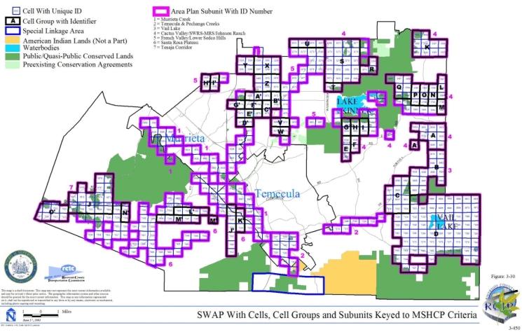
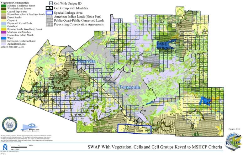
3.3.16 Temescal Canyon Area Plan
➤ Target Acreages
➤ Applicable Cores and Linkages
➤ Area Plan Subunits
TABLE 3-17
CRITERIA FOR TEMESCAL CANYON AREA PLAN
| Sub Unit |
Cell Group | Quadrat Number |
USGS Section |
Quarter Section |
Criteria |
|---|---|---|---|---|---|
| SUBUNIT 1 - Santa Ana River to Santa Ana Mountains | |||||
| 1 | 1702 | 30 | SW | Conservation within this Cell will contribute to assembly of Proposed Constrained Linkage 1. Conservation within this Cell will focus on coastal sage scrub and grassland. Areas conserved within this Cell will be connected to coastal sage scrub habitat proposed for conservation in Cells #1704 to the east and #1811 to south. Conservation within this Cell will range from 20%-30% of the Cell focusing on the eastern portion Cell. | |
| 1 | 1704 | 30 | SE | Conservation within this Cell will contribute to assembly of Proposed Constrained Linkage 1. Conservation within this Cell will focus on coastal sage scrub. Areas conserved within this Cell will be connected to coastal sage scrub habitat proposed for conservation in Cells #1812 and #1702 to the south and west. Conservation within this Cell will be approximately 5% focusing on the southwestern portion of the Cell. | |
| 1 | 1706 | 29 | SW | Conservation within this Cell will contribute to assembly of Proposed Constrained Linkage 2. Conservation within this Cell will focus on riparian scrub, woodland, forest, associated with the Prado Flood Control Basin and the Santa Ana River and grassland. Areas conserved within this Cell will be connected to habitat proposed for conservation in Cells #1813 and #1616 to the south and north. Conservation within this Cell will range from 15%-25% focusing on the western portion of the Cell. | |
| 1 | 1811 | 31 | NW | Conservation within this Cell will contribute to assembly of Proposed Constrained Linkage 1. Conservation within this Cell will focus on coastal sage scrub, chaparral, and water. Areas conserved within this Cell will be connected to uplands proposed for conservation to the south, east, and north in Cells #1896, #1812, and #1702. Conservation within this Cell will range from 50%-60% focusing on the eastern portion of the Cell. | |
| 1 | 1812 | 31 | NE | Conservation within this Cell will contribute to assembly of Proposed Constrained Linkage 1. Conservation within this Cell will focus on coastal sage scrub and chaparral. Areas conserved within this Cell will be connected to chaparral and coastal sage scrub habitat proposed for conservation in Cells #1898, #1811, and Cell #1704 to the south, west, and north. Conservation within this Cell will range from 25%-35% focusing on the western portion of the Cell. | |
| 1 | 1813 | 32 | NW | Conservation within this Cell will contribute to assembly of Proposed Constrained Linkage 2. Conservation within this Cell will focus on coastal sage scrub, and riparian scrub, woodland, forest. Areas conserved within this Cell will be connected to riparian scrub, woodland, forest, coastal sage scrub and chaparral habitat proposed for conservation in Cell #1900 to the south, and to wetlands in Cell #1706 to the north. Conservation within this Cell will range from 15%-25% focusing on the eastern portion of the Cell. | |
| 1 | 1896 | 31 | SW | Conservation within this Cell will contribute to assembly of Proposed Constrained Linkage 1. Conservation within this Cell will focus on chaparral and coastal sage scrub. Areas conserved within this Cell will be connected to chaparral and coastal sage scrub habitat proposed for conservation in Cells #1898 and #1811 to the east and north. Conservation within this Cell will range from 5%-15% focusing on the northeastern portion of the Cell. | |
| 1 | 1898 | 31 | SE | Conservation within this Cell will contribute to assembly of Proposed Constrained Linkage 1. Conservation within this Cell will focus on chaparral and coastal sage scrub. Areas conserved within this Cell will be connected to chaparral and coastal sage scrub habitat proposed for conservation in Cell #1812 to the north. Conservation within this Cell will range from 50%-60% focusing on the eastern and northern portions of the Cell. | |
| 1 | 1900 | 32 | SW | Conservation within this Cell will contribute to assembly of Proposed Constrained Linkage 1. Conservation within this Cell will focus on chaparral, coastal sage scrub, and riparian scrub, woodland, forest. Areas conserved within this Cell will be connected to chaparral habitat proposed for conservation in Cell #1898 to the west, to chaparral and coastal sage scrub habitat proposed for conservation in Cell #1902 to the east, and a variety of upland and wetland habitats proposed for conservation to the north in Cell #1813. Conservation within this Cell will range from 30%-40% focusing on the eastern portions of the Cell. | |
| 1 | 1902 | 32 | SE | Conservation within this Cell will contribute to assembly of Proposed Constrained Linkage 2. Conservation within this Cell will focus on chaparral and coastal sage scrub. Areas conserved within this Cell will be connected to chaparral habitat proposed for conservation in Cell #1900 to the west. Conservation within this Cell will range from 5%-15% focusing on the southwestern portions of the Cell. | |
| SUBUNIT 2 - Prado Basin | |||||
| 2 | A | 1331 | 18 | SE | Conservation within this Cell Group will contribute to assembly of Proposed Extension of Existing Core 1 and Existing Core A. Conservation within this Cell Group will focus on riparian scrub, woodland, forest associated with the Prado Flood Control Basin and the Santa Ana River, and coastal sage scrub. Areas conserved within this Cell will be connected to wetlands proposed for conservation in Cell Group B to the south. Conservation within this Cell Group will range from 40%-50% focusing on the western portions of the Cell Group. |
| 2 | A | 1426 | 19 | NE | |
| 2 | B | 1520 | 19 | SE | Conservation within this Cell Group will contribute to assembly of Proposed Extension of Existing Core 1 and Existing Core A. Conservation within this Cell Group will focus on a variety of wetland habitat associated with the Prado Flood Control Basin and the Santa Ana River, and grassland. Areas conserved within this Cell will be connected to wetlands and uplands proposed for conservation in Cell #1616 to the east, and Cell Group A to the north. Conservation within this Cell Group will range from 20%-30% focusing on the northern and southeastern portions of the Cell Group. |
| 2 | B | 1612 | 30 | NE | |
| 2 | 1616 | 29 | NW | Conservation within this Cell will contribute to assembly of Existing Core A. Conservation within this Cell will focus on a variety of wetland habitat associated with the Prado Flood Control Basin and the Santa Ana River, and grassland. Areas conserved within this Cell will be connected to wetlands and uplands proposed for conservation in Cell Group B to the west and Cell #1706 to the south. Conservation within this Cell Group will range from 25%-35% focusing on the central and western portions of the Cell. | |
| SUBUNIT 3 - Temescal Wash West | |||||
| 3 | C | 2400 | 16 | NW | Conservation within this Cell Group will contribute to assembly of Proposed Extension of Existing Core 2. Conservation within this Cell Group will focus on coastal sage scrub, grassland, and riparian scrub, woodland, forest associated with Temescal Wash. Areas conserved within this Cell Group will be connected to uplands and wetlands proposed for conservation in Cells #2304, #2306, #2307, and #2308 to the north, and Cell Group D to the south. Conservation within this Cell Group will range from 55%-65% of the Cell Group focusing on the central and eastern portions of the Cell Group. |
| 3 | C | 2402 | 16 | NE | |
| 3 | C | 2403 | 15 | NW | |
| 3 | C | 2404 | 15 | NE | |
| 3 | C | 2507 | 15 | SW | |
| 3 | C | 2509 | 15 | SE | |
| 3 | C | 2612 | 22 | NE | |
| 3 | D | 2610 | 22 | NW | Conservation within this Cell Group will contribute to assembly of Proposed Extension of Existing Core 2. Conservation within this Cell Group will focus on coastal sage scrub, grassland, and wetland habitat. Areas conserved within this Cell Group will be connected to a variety of uplands proposed for conservation in Cell Groups C and E to the north and south. Conservation within this Cell Group will range from 75%-85% of the Cell Group focusing on the central and eastern portions of the Cell Group. |
| 3 | D | 2720 | 22 | SE | |
| 3 | D | 2723 | 22 | SW | |
| 3 | E | 2827 | 27 | NW | Conservation within this Cell Group will contribute to assembly of Proposed Extension of Existing Core 2. Conservation within this Cell Group will focus on coastal sage scrub and Riversidean alluvial fan sage scrub in a mosaic of upland habitat, and water and riparian scrub, woodland, forest habitat. Areas conserved within this Cell Group will be connected to a variety of uplands and wetlands proposed for conservation in Cell Group D to the north and Cell Group F to the south. Conservation within this Cell Group will range from 65%-75% of the Cell Group focusing on the central portions of the Cell Group. |
| 3 | E | 2828 | 27 | NE | |
| 3 | E | 2829 | 26 | NW | |
| 3 | E | 2830 | 26 | NE | |
| 3 | E | 2931 | 27 | SE | |
| 3 | E | 2932 | 26 | SW | |
| 3 | E | 2934 | 26 | SE | |
| 3 | F | 3035 | 34 | NE | Conservation within this Cell Group will contribute to assembly of Proposed Extension of Existing Core 2. Conservation within this Cell Group will focus on coastal sage scrub and Riversidean alluvial fan sage scrub in a mosaic of upland habitat, and water and riparian scrub, woodland, forest habitat. Areas conserved within this Cell Group will be connected to a variety of uplands and wetlands proposed for conservation in Cell Group E to the north, Cell Group G to the south, and to coastal sage scrub habitat proposed for conservation in Cells #2937 and #2935 in the Lake Matthews Area Plan to the north. Conservation within this Cell Group will range from 65%-75% of the Cell Group focusing on the central and eastern portions of the Cell Group. |
| 3 | F | 3036 | 35 | NW | |
| 3 | F | 3037 | 36 | NE | |
| 3 | F | 3039 | 35 | NE | |
| 3 | F | 3041 | 36 | NW | |
| 3 | G | 3142 | 35 | SE | Conservation within this Cell Group will contribute to assembly of Proposed Extension of Existing Core 2. Conservation within this Cell Group will focus on assembly of coastal sage scrub and Riversidean alluvial fan sage scrub, chaparral, and water and riparian scrub, woodland, forest habitat. Areas conserved within this Cell Group will be connected to a variety of uplands and wetlands proposed for conservation in Cell Group F to the north, Cell Group H to the south, and to coastal sage scrub habitat proposed for conservation in Cell Group C in the Lake Matthews Area Plan to the east. Conservation within this Cell Group will range from 75%-85% of the Cell Group focusing on the central and eastern portions of the Cell Group. |
| 3 | G | 3143 | 36 | SW | |
| 3 | G | 3144 | 36 | SE | |
| 3 | H | 3245 | 02 | NE | Conservation within this Cell Group will contribute to assembly of Proposed Extension of Existing Core 2. Conservation within this Cell Group will focus on coastal sage scrub in a mosaic of upland habitat, and water and riparian scrub, woodland, forest habitat. Areas conserved within this Cell Group will be connected to a variety of uplands and wetlands proposed for conservation in Cell Group G to the north, Cell Group I to the south, and to coastal sage scrub habitat proposed for conservation in Cell #3249 in the Elsinore Area Plan to the east. Conservation within this Cell Group will range from 70%-80% of the Cell Group focusing on the central and eastern portions of the Cell Group. |
| 3 | H | 3246 | 01 | NW | |
| 3 | H | 3248 | 01 | NE | |
| 3 | I | 3348 | 02 | SE | Conservation within this Cell Group will contribute to assembly of Proposed Extension of Existing Core 2. Conservation within this Cell Group will focus on Riversidean alluvial fan sage scrub, coastal sage scrub, and riparian scrub, woodland, forest habitat. Areas conserved within this Cell Group will be connected to a variety of uplands and wetlands proposed for conservation in Cell Group H to the north, to coastal sage scrub habitat proposed for conservation in Cell #3448 in the Elsinore Area Plan to the south, and to coastal sage scrub, riparian habitat and water proposed for conservation in Cell #3351 in the Elsinore Area Plan to the east. Conservation within this Cell Group will range from 55%-65% of the Cell Group focusing on the northern and eastern portions of the Cell Group. |
| 3 | I | 3349 | 01 | SW | |
| 3 | I | 3350 | 01 | SE | |
| 3 | 1826 | 32 | NE | Conservation within this Cell will contribute to assembly of Proposed Constrained Linkage 4. Conservation within this Cell will focus on water associated with Temescal Wash. Areas conserved within this Cell will be connected to water proposed for conservation to the south in Cell #1923. Conservation within this Cell will range from 15%-25% focusing on the southern portion of the Cell. | |
| 3 | 1923 | 32 | SE | Conservation within this Cell will contribute to assembly of Proposed Constrained Linkage 4. Conservation within this Cell will focus on water and riparian habitat associated with Temescal Wash. Areas conserved within this Cell will be connected to water proposed for conservation to the north in Cell #1826, and to riparian habitat proposed for conservation in Cell #1924 to the east. Conservation within this Cell will range from 10%-20% focusing on the northern and eastern portions of the Cell. | |
| 3 | 1924 | 33 | SW | Conservation within this Cell will contribute to assembly of Proposed Constrained Linkage 4. Conservation within this Cell will focus on riparian scrub, woodland, forest associated with Temescal Wash. Areas conserved within this Cell will be connected to riparian habitat proposed for conservation to the west and south in Cells #1923 and #2018. Conservation within this Cell will range from 5%-15% focusing on the western portions of the Cell. | |
| 3 | 2018 | 05 | NE | Conservation within this Cell will contribute to assembly of Proposed Constrained Linkage 4. Conservation within this Cell will focus on riparian scrub, woodland, forest and water associated with Temescal Wash, and coastal sage scrub. Areas conserved within this Cell will be connected to riparian habitat proposed for conservation to the north in Cell #1924, and to riparian habitat and coastal sage scrub proposed for conservation to the south and southeast in Cells #2113 and #2114. Conservation within this Cell will range from 15%-25% focusing on the central and southeastern portions of the Cell. | |
| 3 | 2019 | 04 | NW | Conservation within this Cell will contribute to assembly of Proposed Constrained Linkage 4. Conservation within this Cell will focus on riparian scrub, woodland, forest associated with Temescal Wash. Areas conserved within this Cell will be connected to riparian habitat proposed for conservation in Cells #2018, #2113, and #2114 to the west, southwest, and south. Conservation within this Cell will be approximately 5% focusing on the south and southwestern portions of the Cell. | |
| 3 | 2113 | 05 | SE | Conservation within this Cell will contribute to assembly of Proposed Constrained Linkage 4. Conservation within this Cell will focus on riparian scrub, woodland, forest associated with Temescal Wash, and coastal sage scrub. Areas conserved within this Cell will be connected to riparian habitat proposed for conservation in Cell #2114 to the east, and to riparian habitat and coastal sage scrub proposed for conservation in Cell #2018 to the north. Conservation within this Cell will be approximately 5% focusing on the northeastern portion of the Cell. | |
| 3 | 2114 | 04 | SW | Conservation within this Cell will contribute to assembly of Proposed Constrained Linkage 4. Conservation within this Cell will focus on riparian scrub, woodland, forest associated with Temescal Wash, coastal sage scrub. Areas conserved within this Cell will be connected to riparian habitat and coastal sage scrub proposed for conservation in Cells #2019, #2113, and #2206 to the north, west, and south. Conservation within this Cell will range from 15%-25% focusing on the north and eastern portions of the Cell. | |
| 3 | 2206 | 09 | NW | Conservation within this Cell will contribute to assembly of Proposed Constrained Linkage 4. Conservation within this Cell will focus on riparian scrub, woodland, forest associated with Temescal Wash, grassland, and coastal sage scrub. Areas conserved within this Cell will be connected to riparian habitat and coastal sage scrub proposed for conservation in Cell #2304 to the south and in Cell #2114 to the north. Conservation within this Cell will range from 35%-45% focusing on the eastern portions of the Cell. | |
| 3 | 2208 | 09 | NE | Conservation within this Cell will contribute to assembly of Proposed Constrained Linkage 4. Conservation within this Cell will focus on grassland. Areas conserved within this Cell will be connected to grassland habitat proposed for conservation in Cell #2206 to the west, and to coastal sage scrub and riparian habitat proposed for conservation in Cell #2306 to the south. Conservation within this Cell will be approximately 5% focusing on the western portion of the Cell. | |
| 3 | 2304 | 09 | SW | Conservation within this Cell will contribute to assembly of Proposed Extension of Existing Core 2. Conservation within this Cell will focus on riparian scrub, woodland, forest associated with Temescal Wash, coastal sage scrub and grassland. Areas conserved within this Cell will be connected to uplands and wetlands proposed for conservation in Cells #2206 and #2306 to the north and east, and Cell Group C to the south. Conservation within this Cell will range from 20%-30% focusing on the eastern portion of the Cell. | |
| 3 | 2306 | 09 | SE | Conservation within this Cell will contribute to assembly of Proposed Extension of Existing Core 2. Conservation within this Cell will focus on riparian scrub, woodland, forest associated with Temescal Wash, coastal sage scrub and grassland. Areas conserved within this Cell will be connected to riparian habitat and grassland proposed for conservation in Cell #2304 to the west and Cell Group C to the south, and to adjacent riparian scrub proposed for conservation in Cell #2206 to the northwest. Conservation within this Cell will range from 70%-80% focusing on the central and western portions of the Cell. | |
| SUBUNIT 4 - La Sierra Hills/Lake Mathews West | |||||
| 4 | 2117 | 03 | SE | Conservation within this Cell will contribute to assembly of Proposed Extension of Existing Core 2. Conservation within this Cell will focus on coastal sage scrub, grassland, and riparian habitat. Areas conserved within this Cell will be connected to coastal sage scrub, and riparian habitat proposed for conservation in Cell #2211 to the south, and to grassland and coastal sage scrub habitat proposed for conservation in Cell Group B in the Lake Matthew Area Plan to the east. Conservation within this Cell will range from 30%-40% focusing on the eastern portions of the Cell. | |
| 4 | 2211 | 10 | NE | Conservation within this Cell will contribute to assembly of Proposed Extension of Existing Core 2. Conservation within this Cell will focus on coastal sage scrub, grassland, and riparian habitat. Areas conserved within this Cell will be connected to coastal sage scrub and riparian habitat proposed for conservation in Cell #2117 to the north, to grassland, coastal sage scrub, and riparian habitat proposed for conservation in Cell #2308 to the south, and to riparian scrub and coastal sage scrub proposed for conservation in Cell Group B in the Lake Matthews Area Plan to the east. Conservation within this Cell will range from 50%-60% focusing on the eastern portions of the Cell. | |
| 4 | 2307 | 10 | SW | Conservation within this Cell will contribute to assembly of Proposed Extension of Existing Core 2. Conservation within this Cell will focus on coastal sage scrub, grassland, and riparian habitat. Areas conserved within this Cell will be connected to riparian habitat and coastal sage scrub proposed for conservation in Cell Group C to the south, and to grassland, riparian habitat and coastal sage scrub proposed for conservation in Cells #2306 and #2308 to the west and east. Conservation within this Cell will range from 10%-20% focusing on the southeastern portion of the Cell. | |
| 4 | 2308 | 10 | SE | Conservation within this Cell will contribute to assembly of Proposed Extension of Existing Core 2. Conservation within this Cell will focus on coastal sage scrub, grassland, and riparian habitat. Areas conserved within this Cell will be connected to riparian habitat, grassland, and coastal sage scrub proposed for conservation in Cell #2211 to the north, and Cell #2307 to the west, to grassland and coastal sage scrub habitat proposed for conservation in Cell Group C to the south, and to coastal sage scrub habitat proposed for conservation in Cell Group B in the Lake Matthews Area Plan to the east. Conservation within this Cell will range from 75%-85% focusing on the central and eastern portions of the Cell. | |
| SUBUNIT 5 - Temescal/Santa Ana Mountains | |||||
| 5 | 3448 | 12 | NE | Conservation within this Cell will contribute to assembly of Proposed Constrained Linkage 3. Conservation within this Cell will focus on grassland and coastal sage scrub. Areas conserved within this Cell will be connected to grassland habitat proposed for conservation in Cell # 3546 to the south. Conservation within this Cell will be approximately 5% focusing on the south-central portion of the Cell. | |
| 5 | 3545 | 12 | SW | Conservation within this Cell will contribute to assembly of Proposed Constrained Linkage 3. Conservation within this Cell will focus on coastal sage scrub and grassland. Areas conserved within this Cell will be connected to coastal sage scrub habitat proposed for conservation in Cell # 3546 to the east. Conservation within this Cell will range from 5-15% focusing on the east-central portion of the Cell. | |
| 5 | 3546 | 12 | SE | Conservation within this Cell will contribute to assembly of Proposed Constrained Linkage 3. Conservation within this Cell will focus on coastal sage scrub, grassland, woodlands and forest, and chaparral. Areas conserved within this Cell will be connected to grassland habitat proposed for conservation in Cell # 3448 to the north, and to coastal sage scrub habitat proposed for conservation in Cell # 3545 to the west. Conservation within this Cell will range from 25-35% focusing on the western and northern portions of the Cell. | |
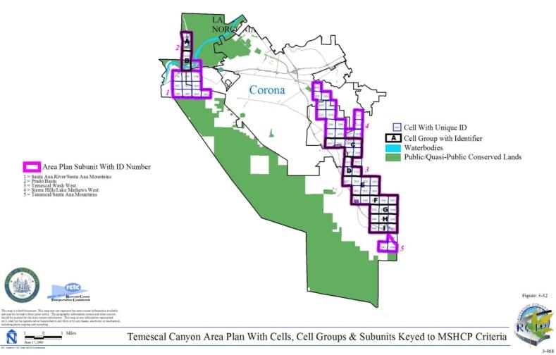
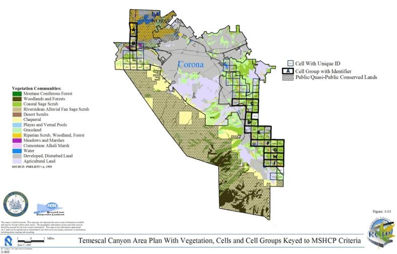
3.3.17. Cities of Riverside/Norco
➤ Target Acreages
➤ Applicable Cores and Linkages
➤ Area Plan Subunits
TABLE 3-18
CRITERIA FOR CITIES OF RIVERSIDE/NORCO
| Sub Unit |
Cell Group | Quadrat Number |
USGS Section |
Quarter Section |
Criteria |
|---|---|---|---|---|---|
| SUBUNIT 1 - Santa Ana River South | |||||
| 1 | 443 | 22 | SW | Conservation within this Cell will contribute to assembly of Existing Core A. Conservation within this Cell will focus on Riversidean alluvial fan sage scrub, riparian scrub, woodland and forest habitat along the Santa Ana River. Areas conserved within this Cell will be connected to existing conserved wetland habitat along the Santa Ana River in Cell #534 to the southwest. Conservation within this Cell will be approximately 5% of the Cell focusing in the western portion of the Cell. | |
| 1 | 534 | 28 | NE | Conservation within this Cell will contribute to assembly of Existing Core A. Conservation within this Cell will focus on grassland, riparian scrub, woodland and forest habitat expanding existing conserved wetland habitat along the Santa Ana River. Conservation within this Cell will range from 15%-25% of the Cell focusing in the southwestern portion of the Cell. | |
| 1 | 617 | 25 | SW | Conservation within this Cell will contribute to assembly of Existing Core A. Conservation within this Cell will focus on lands connecting existing conserved wetland habitat along the Santa Ana River based on existing land constraints. Areas conserved within this Cell will be connected to habitat proposed for conservation in Cell #617 in the Jurupa Area Plan to the north. Conservation within this Cell will be approximately 5% of the Cell focusing in the eastern portion of the Cell. | |
| 1 | 621 | 29 | SW | Conservation within this Cell will contribute to assembly of Existing Core A. Conservation within this Cell will focus on lands expanding existing conserved wetland habitat along the Santa Ana River. Conservation within this Cell will be approximately 5% of the Cell focusing in the northeastern portion of the Cell. | |
| 1 | 699 | 32 | NW | Conservation within this Cell will contribute to assembly of Existing Core A. Conservation within this Cell will focus on riparian scrub, woodland, forest and water habitat adjacent to the Santa Ana River. Areas conserved within this Cell will be connected to riparian scrub, woodland, and forest habitat proposed for conservation adjacent to the Santa Ana River in Cell #700 to the east and to riparian scrub, woodland, forest and water habitat proposed for conservation along the Santa Ana River in Cell #699 in the Jurupa Area Plan to the north. Conservation within this Cell will range from 20%-30% of the Cell focusing in the southern portion of the Cell. | |
| 1 | 700 | 32 | NE | Conservation within this Cell will contribute to assembly of Existing Core A. Conservation within this Cell will focus on riparian scrub, woodland, forest and water habitat adjacent to the Santa Ana River. Areas conserved within this Cell will be connected to riparian scrub, woodland, and forest habitat proposed for conservation along the Santa Ana River in Cell #699 to the west and to riparian scrub, woodland, forest and water habitat proposed for conservation along the Santa Ana River in Cell #700 in the Jurupa Area Plan to the north. Conservation within this Cell will range from 15%-25% of the Cell focusing in the central portion of the Cell. | |
| 1 | 875 | 01 | NW | Conservation within this Cell will contribute to assembly of Existing Core A. Conservation within this Cell will focus on riparian scrub, woodland and forest habitat along the Santa Ana River. Areas conserved within this Cell together with habitat proposed for conservation in Cell #876 to the east, #965 to the south, and #964 to the southwest will provide a connection from existing conserved wetland habitat northeast of Cell #876 to existing conserved wetland habitat southwest of Cell #964, and will also be connected to habitat proposed for conservation along the Santa Ana River in Cell #875 in the Eastvale Area Plan to the north. Conservation within this Cell will be approximately 5% of the Cell focusing in the southeastern portion of the Cell. | |
| 1 | 876 | 01 | NE | Conservation within this Cell will contribute to assembly of Existing Core A. Conservation within this Cell will focus on riparian scrub, woodland and forest habitat along the Santa Ana River. Areas conserved within this Cell together with habitat proposed for conservation in Cell #875 to the west, and #964 and #965 to the southwest will provide a connection from existing conserved wetland habitat northeast of this Cell to existing conserved wetland habitat southwest of Cell #964, and will also be connected to habitat proposed for conservation along the Santa Ana River in Cell #876 in the Eastvale Area Plan to the north. Conservation within this Cell will be approximately 5% of the Cell focusing in the western portion of the Cell. | |
| 1 | 964 | 02 | SE | Conservation within this Cell will contribute to assembly of Existing Core A. Conservation within this Cell will focus on grassland habitat along the Santa Ana River. Areas conserved within this Cell together with habitat proposed for conservation in Cell #965 to the east, and #875 and #876 to the northeast will provide a connection from existing conserved wetland habitat northeast of Cell #876 to existing conserved wetland habitat southwest of this Cell, and will also be connected to land proposed for conservation along the Santa Ana River in Cell #964 in the Eastvale Area Plan to the north. Conservation within this Cell will be approximately 5% of the Cell focusing in the southern portion of the Cell. | |
| 1 | 965 | 01 | SW | Conservation within this Cell will contribute to assembly of Existing Core A. Conservation within this Cell will focus on riparian scrub, woodland and forest habitat along the Santa Ana River. Areas conserved within this Cell together with habitat proposed for conservation in Cell #875 to the north, #876 to the northeast and #964 to the west will provide a connection from existing conserved wetland habitat northeast of Cell #876 to existing conserved wetland habitat southwest of Cell #964, and will also be connected to land proposed for conservation along the Santa Ana River in Cell #965 in the Eastvale Area Plan to the north. Conservation within this Cell will range from 5%-15% of the Cell focusing in the northern portion of the Cell. | |
| SUBUNIT 2 - Sycamore Canyon West | |||||
| 2 | 634 | 29 | SE | Conservation within this Cell will contribute to assembly of Proposed Constrained Linkage 7. Conservation within this Cell will focus on upland scrub habitat. Areas conserved within this Cell will be connected to upland scrub habitat proposed for conservation in Cell #635 in the Highgrove Area Plan to the east and in Cell #719 to the south. Conservation within this Cell will be approximately 5% of the Cell focusing in the eastern portion of the Cell. | |
| 2 | 719 | 32 | NE | Conservation within this Cell will contribute to assembly of Proposed Constrained Linkage 7. Conservation within this Cell will focus on coastal sage scrub and grassland habitat. Areas conserved within this Cell will be connected to coastal sage scrub habitat proposed for conservation in Cell #721 in the Highgrove Area Plan to the east. Conservation within this Cell will range from 15%-25% of the Cell focusing in the southeastern portion of the Cell. | |
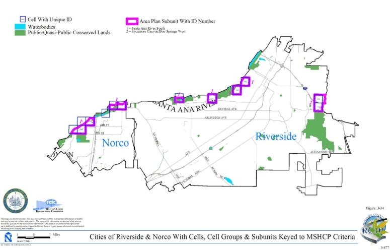
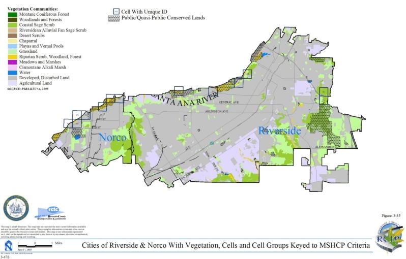
3.4 ALTERNATIVES CONSERVATION STRATEGIES CONSIDERED IN THE CONSERVATION PLANNING PROCESS
3.4.1 Listed, Proposed and Strong Candidate Species Alternative
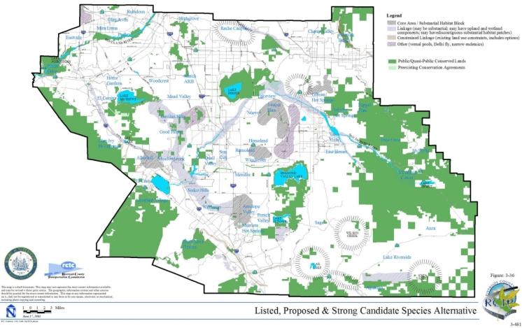
| TABLE 3-19 LISTED, PROPOSED AND STRONG CANDIDATE SPECIES ALTERNATIVE VEGETATION SUMMARY |
|||||
|---|---|---|---|---|---|
| Vegetation Type | Total Acres in Plan Area |
Total Acres in Existing Public/Quasi-Public Lands |
Total Acres of Additional Reserve Lands |
Total Acres Conserved |
Percent of Total Vegetation Community Acres Conserved in Plan Area |
| Agriculture | 169,480 | 11,480 | 14,900 | 26,380 | 16% |
| Chaparral | 434,950 | 207,380 | 39,610 | 246,990 | 57% |
| Cismontane Alkali Marsh | 1,260 | <5 | <5 | <5 | <1% |
| Coastal Sage Scrub | 156,450 | 34,560 | 39,180 | 73,740 | 47% |
| Desert Scrubs | 14,570 | 1,310 | 150 | 1,460 | 10% |
| Grassland | 154,140 | 22,810 | 15,220 | 38,030 | 25% |
| Meadows and Marshes | 1,020 | 330 | 100 | 430 | 42% |
| Montane Coniferous Forest | 29,910 | 20,480 | 30 | 20,510 | 69% |
| Playas and Vernal Pools | 7,910 | 2,920 | 2,930 | 5,850 | 74% |
| Riparian Scrub, Woodland, Forest | 15,030 | 7,270 | 2,100 | 9,370 | 62% |
| Riversidean Alluvial Fan Sage Scrub | 7,940 | 2,060 | 2,380 | 4,440 | 56% |
| Unknown | 1,350 | 1,230 | 10 | 1,240 | 92% |
| Water | 12,210 | 9,150 | 940 | 10,090 | 83% |
| Woodlands and Forests | 34,300 | 20,770 | 1,750 | 22,520 | 66% |
| Developed or Disturbed Land | 218,260 | 4,780 | – | 4,780 | 2% |
| TOTALS | 1,258,780 | 346,530 | 119,300 | 465,830 | |
3.4.2 Listed and Proposed Species Alternative
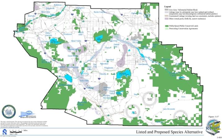
| TABLE 3-20 LISTED AND PROPOSED SPECIES ALTERNATIVE VEGETATION SUMMARY |
|||||
|---|---|---|---|---|---|
| Vegetation Type | Total Acres in Plan Area |
Total Acres in Existing Public/Quasi-Public Lands |
Total Acres of Additional Reserve Lands |
Total Acres Conserved |
Percent of Total Vegetation Community Acres Conserved in Plan Area |
| Agriculture | 169,480 | 11,480 | 14,900 | 26,380 | 16% |
| Chaparrel | 434,950 | 207,380 | 27,010 | 234,390 | 54% |
| Cismontane Alkali Marsh | 1,260 | <5 | <5 | <5 | <1% |
| Coastal Sage Scrub | 156,450 | 34,560 | 29,830 | 64,390 | 41% |
| Desert Scrubs | 14,570 | 1,310 | – – | 1,310 | 9% |
| Grassland | 154,140 | 22,810 | 11,210 | 34,020 | 22% |
| Meadows and Marshes | 1,020 | 330 | 80 | 410 | 40% |
| Montane Coniferous Forest | 29,910 | 20,480 | 30 | 20,510 | 69% |
| Playas and Vernal Pools | 7,910 | 2,920 | 2,930 | 5,850 | 74% |
| Riparian Scrub, Woodland, Forest | 15,030 | 7,270 | 1,800 | 9,070 | 60% |
| Riversidean Alluvial Fan Sage Scrub | 7,940 | 2,060 | 2,360 | 4,420 | 56% |
| Unknown | 1,350 | 1,230 | 10 | 1,240 | 92% |
| Water | 12,210 | 9,150 | 860 | 10,010 | 82% |
| Woodlands and Forests | 34,300 | 20,770 | 1,590 | 22,360 | 65% |
| Developed or Disturbed Land | 218,260 | 4,780 | – – | 4,780 | 2% |
| TOTALS | 1,258,780 | 346,530 | 92,610 | 439,140 | |
3.4.3 Existing Reserves
| TABLE 3-21 EXISTING RESERVES ALTERNATIVE VEGETATION SUMMARY |
|||||
|---|---|---|---|---|---|
| Vegetation Type | Total Acres in Plan Area |
Total Acres in Existing Public/Quasi-Public Lands |
Percent of Total Vegetation Community Acres Conserved in Plan Area |
||
| Agriculture | 169,480 | 11,480 | 7% | ||
| Chaparral | 434,950 | 207,380 | 48% | ||
| Cismontane Alkali Marsh | 1,260 | <5 | <1% | ||
| Coastal Sage Scrub | 156,450 | 34,560 | 22% | ||
| Desert Scrubs | 14,570 | 1,310 | 9% | ||
| Grassland | 154,140 | 22,810 | 15% | ||
| Meadows and Marshes | 1,020 | 330 | 32% | ||
| Montane Coniferous Forest | 29,910 | 20,480 | 68% | ||
| Playas and Vernal Pools | 7,910 | 2,920 | 37% | ||
| Riparian Scrub, Woodland, Forest | 15,030 | 7,270 | 48% | ||
| Riversidean Alluvial Fan Sage Scrub | 7,940 | 2,060 | 26% | ||
| Unknown | 1,350 | 1,230 | 91% | ||
| Water | 12,210 | 9,150 | 75% | ||
| Woodlands and Forests | 34,300 | 20,770 | 61% | ||
| Developed or Disturbed Land | 218,260 | 4,780 | 2% | ||
| TOTALS | 1,258,780 | 346,530 | |||
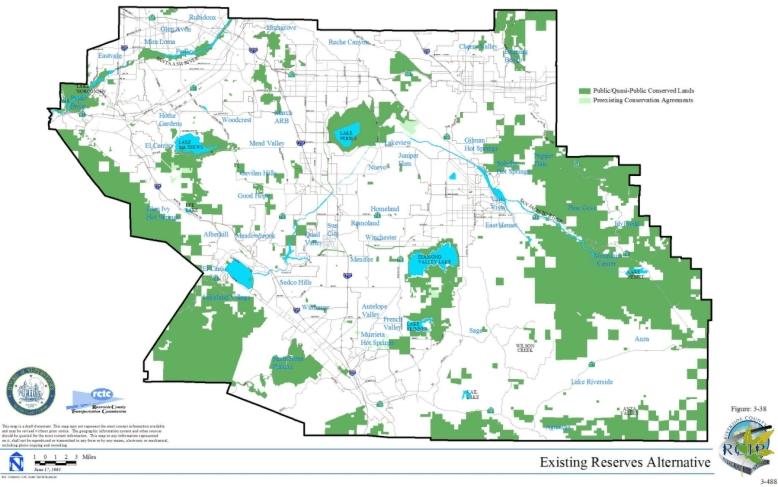
| TABLE 3-22 SUMMARY OF POTENTIAL SPECIES CONSERVATION UNDER EXISTING RESERVES ALTERNATIVE |
||
|---|---|---|
| Common Name | Scientific Name | Notes |
| LISTED AND PROPOSED SPECIES | ||
| Invertebrates/Crustaceans | ||
| Riverside fairy shrimp | Streptocephalus woottoni | Not conserved, Hemet and other potential habitat not conserved. |
| vernal pool fairy shrimp | Branchinecta lynchi | Not conserved, although conserved at Santa Rosa Plateau, it is not conserved elsewhere. |
| Invertebrates/Insects | ||
| Quino checkerspot butterfly | Euphydryas editha quino | Not conserved, Sage, Wilson Valley, Murrieta and Temecula not included. |
| Delhi Sands flower-loving fly | Rhaphiomidas terminatus abdominalis | Not conserved, Mira Loma, Jurupa not included. |
| Fish | ||
| Santa Ana sucker | Catastomus santaanae | Not conserved, because the breeding areas for the fish, Temescal Wash and San Timoteo Creek, are not included. |
| Amphibians | ||
| California red-legged frog | Rana aurora draytonii | Conserved depending on 4-forest plan and Santa Rosa Plateau. |
| mountain yellow-legged frog | Rana muscosa | Conserved depending on 4-forest plan. |
| arroyo toad | Bufo californicus | Not conserved, habitat. |
| Reptiles | ||
| southern rubber boa | Charina bottae umbratica | Not conserved, habitat |
| Birds | ||
| bald eagle | Haliaeetus leucocephalus | Not conserved, needs larger foraging area around the lakes that they winter at (such as Lake Elsinore, Lake Perris, Vail Lake, Lake Skinner, Lake Mathews). Need less urbanization within the areas where they winter. |
| coastal California gnatcatcher | Polioptila californica californica | Not conserved, missing key populations in Alberhill, Sedco Hills, Canyon Lake, and corridor connection to Lake Skinner. |
| least Bell's vireo | Vireo bellii pusillus | Not conserved, still need other populations in Temecula Creek, Wilson Creek, Santa Margarita River, Potrero Creek, Murrieta Creek, Temescal Wash, San Timoteo Creek, Chino Creek, Alberhill Creek, Tucalota Creek; although do get Santa Ana River and Prado, it's missing too many key populations. |
| mountain plover | Charadrius montanus | Not conserved, need Mystic Lake and foraging area in the Menifee/Winchester/Perris/Nuevo area. |
| peregrine falcon | Falco peregrinus | Conserved, regular visiting areas are protected at Prado Basin, Santa Ana River, San Jacinto Wildlife Area, Lake Perris, Lake Skinner. |
| southwestern willow flycatcher | Empidonax traillii extimus | Not conserved, although population in Prado Basin and Santa Ana River is protected, all locations are key and this misses the locations in Temecula River, Santa Margarita River, Murrieta Creek. |
| Swainson's hawk | Buteo swainsoni | Not conserved, because could occur anywhere and don't get sufficient foraging habitat in central part. |
| western yellow-billed cuckoo | Coccyzus americanus occidentalis | Conserved, only populations are in Santa Ana River and Prado Basin. |
| Mammals | ||
| San Bernardino kangaroo rat | Dipodomys merriami parvus | Not conserved, populations in Upper San Jacinto & Bautista not included. |
| Stephens' kangaroo rat | Dipodomys stephensi | Conserved, however, coverage would not be expanded to populations outside of existing HCP area. |
| Plants | ||
| California Orcutt grass | Orcuttia californica | Not conserved, doesn't include habitat where it is located (Salt Creek). |
| Mojave tarplant | Deinandra mohavensis | Conserved, all known populations in National Forest. |
| Munz's onion | Allium munzii | Not conserved, major populations are not captured within boundaries. |
| Nevin's barberry | Berberis nevinii | Not conserved, area does not encompass Vail Lake. |
| Parish's meadowfoam | Limnanthes gracilis var. parishii | Conserved within the Santa Rosa Plateau Preserve. |
| San Diego ambrosia | Ambrosia pumila | Not conserved, population at Nichols Road is not included. |
| San Diego button-celery | Eryngium aristulatum var. parishii | Conserved, only populations are in Santa Rosa Plateau Preserve. |
| San Jacinto Valley crownscale | Atriplex coronata var. notatior | Not conserved, San Jacinto River, Mystic Lake, or Upper Salt Creek are not included. |
| Santa Ana River woollystar | Eriastrum densifolium ssp. sanctorum | Not conserved, because floodplain along Santa Ana River is not included. |
| slender-horned spine flower | Dodecahema leptoceras | Not conserved, habitat and population Arroyo Seco, Kolb Creek, and Vail Lake are not included. |
| spreading navarretia | Navarretia fossalis | Not conserved, San Jacinto River populations not conserved. |
| thread-leaved brodiaea | Brodiaea filifolia | Not conserved, Population along San Jacinto River is not included. |
| Vail Lake ceanothus | Ceanothus ophiochilus | Not conserved, Vail Lake populations are not conserved. |
| OTHER SPECIES | ||
| Invertebrates/Insects | ||
| Santa Rosa Plateau fairy shrimp | Linderiella santarosae | Conserved |
| Fish | ||
| arroyo chub | Gila orcutti | Not conserved, because only the population in the Santa Ana River is included. The populations in the Santa Margarita, Temescal Wash, and Temecula Creek are not included. |
| Amphibians | ||
| coast range newt | Taricha torosa torosa | Not conserved, habitat |
| western spadefoot | Scaphiopus hammondii | Not conserved, habitat |
| Reptiles | ||
| Belding's orange-throated whiptail | Cnemidophorus hyperythrus beldingi | Not conserved, habitat is not included among boundaries. |
| coastal western whiptail | Cnemidophorus tigris multiscutatus | Not conserved, does not capture habitat. |
| granite night lizard | Xantusia henshawi henshawi | Not conserved, does not capture habitat. |
| granite spiny lizard | Sceloporus orcuttii orcuttii | Not conserved, does not capture habitat. |
| northern red diamond rattlesnake | Crotalus ruber ruber | Probably conserved, sage scrub habitat and rocky chaparral. |
| San Bernardino mtn. kingsnake | Lampropeltis zonata parvirubra | Conditionally conserved depending on 4-forest plan. |
| San Diego banded gecko | Coleonyx variegatus abbottii | Not conserved, most areas not conserved. |
| San Diego horned lizard | Phrynosoma coronatum blainvillei | Not conserved, habitat |
| San Diego mountain kingsnake | Lampropeltis zonata pulchra | Conditionally conserved depending on 4-forest plan. |
| southern sagebrush lizard | Sceloporus graciosus vandenburgianus | Not conserved, habitat |
| western pond turtle | Clemmys marmorata pallida | Not conserved, habitat |
| Birds | ||
| American bittern | Botaurus lentiginosus | Not conserved, because only the population in the Santa Ana River is included. The populations in the Mystic Lake are not included |
| Bell's sage sparrow | Amphispiza belli belli | Not conserved, because don't get breeding locations or foraging area in locations such as Canyon Lake, Wildomar, Murrieta, Badlands. |
| black-crowned night-heron | Nycticorax nycticorax | Conserved, only breeding populations are in Santa Ana River and Prado Basin. |
| black swift (breeding) | Cypseloides niger | This species is conserved with the existing reserves if the 4-forest management plan addresses both listed and non-listed species identified as part of the MSHCP. |
| burrowing owl | Athene cunicularia hypugaea | Not conserved, because don't get sufficient grassland areas such as Aguanga, sage, Temecula area. |
| cactus wren | Campylorhynchus brunneicapillus couesi | Not conserved, because don't get breeding locations in patches dominated by cactus such as Anza, Badlands, Temecula area. |
| California horned lark | Eremophila alpestris actia | Not conserved, because don't get sufficient grassland areas such as Aguanga, sage, Temecula area. |
| California spotted owl | Strix occidentalis occidentalis | This species is conserved with the existing reserves if the 4-forest management plan addresses both listed and non-listed species identified as part of the MSHCP. |
| Cooper's hawk | Accipiter cooperii | Not conserved, because don't get breeding locations or foraging habitat in woodland areas such as Temecula Creek, Murrieta Creek, Alberhill, Canyon Lake. |
| double-crested cormorant | Phalacrocorax auritus | Conserved, only breeding populations are in Santa Ana River and Prado Basin. |
| downy woodpecker | Picoides pubescens | Not conserved, because don't get breeding locations or foraging habitat in woodland areas such as Temecula Creek, Murrieta Creek, Alberhill, Canyon Lake. |
| ferruginous hawk | Buteo regalis | Not conserved, because could occur anywhere and don't get sufficient foraging habitat in central part. |
| golden eagle | Aquila chrysaetos | Not conserved, because don't know locations for nesting and don't get enough foraging habitat or locations such as Badlands, Potrero, Hemet area, and Banning. |
| grasshopper sparrow | Ammodramus savannarum | Not conserved, because don't get the grassland areas such as in Lake Elsinore, Canyon Lake, Murrieta, Temecula. |
| Lincoln's sparrow | Melospiza lincolnii | This species is conserved with the existing reserves if the 4-forest management plan addresses both listed and non-listed species identified as part of the MSHCP. |
| loggerhead shrike | Lanius ludovicianus | Not conserved, because don't get foraging habitat in grassland areas such as Temecula Creek, Murrieta Creek, Badlands, Aguanga. |
| MacGillivray's warbler | Oporonis tolmiei | This species is conserved with the existing reserves if the 4-forest management plan addresses both listed and non-listed species identified as part of the MSHCP. |
| merlin | Falco columbarius | Not conserved, because could occur anywhere and don't get sufficient foraging habitat in central part. |
| mountain quail | Oreortyx pictus | This species is conserved with the existing reserves if the 4-forest management plan addresses both listed and non-listed species identified as part of the MSHCP. |
| Nashville warbler | Vermivora ruficapilla | This species is conserved with the existing reserves if the 4-forest management plan addresses both listed and non-listed species identified as part of the MSHCP. |
| northern goshawk | Accipiter gentilis | This species is conserved with the existing reserves if the 4-forest management plan addresses both listed and non-listed species identified as part of the MSHCP. |
| northern harrier (breeding) | Circus cyaneus | Not conserved, because don't know breed in locations and don't get the areas around Lake Elsinore, Temecula, Murrieta areas. |
| osprey | Pandion haliaetus | Conserved, not known to breed in area. Foraging habitat is protected in the open reservoirs such as Lake Perris, Lake Mathews, Lake Skinner. |
| prairie falcon (breeding) | Falco mexicanus | Not conserved, because could occur anywhere and don''t get breeding locations or sufficient foraging habitat in areas such as Mystic Lake and Moreno Valley/ Beaumont/Banning area. |
| purple martin | Progne subis | This species is conserved with the existing reserves if the 4-forest management plan addresses both listed and non-listed species identified as part of the MSHCP. |
| sharp-shinned hawk | Accipiter striatus | Not conserved, because don't know locations of breeding and don't get sufficient winter foraging areas in the rest of the area such as Banning, Alberhill, Homeland. |
| Southern California rufous-crowned sparrow | Aimophila ruficeps canescens | Not conserved, don''t get sufficient breeding and foraging locations such as Alberhill, Murrieta, Wildomar, Temecula, or the habitat linkages. |
| tree swallow | Tachycineta bicolor | Not conserved, because don't get breeding locations or foraging habitat in woodland areas such as Temecula Creek, Murrieta Creek, Alberhill, Canyon Lake. |
| tricolored blackbird (colony) | Agelaius tricolor | Not conserved, because don't know locations of breeding and don't get past locations such as Mystic Lake and Badlands. |
| turkey vulture (breeding) | Cathartes aura | Not conserved, because don't know locations of breeding, don't get sufficient foraging habitat such as Lakeview Mts and Badlands. |
| white-faced ibis | Plegadis chihi | Not conserved, because need areas around Mystic Lake. |
| white-tailed kite | Elanus leucurus | Not conserved, because don't know breeding locations in wooded or riparian areas or foraging habitat in grassland areas such as Temecula Creek, Murrieta Creek, Alberhill, Canyon Lake. |
| Williamson's sapsucker | Sphyrapicus thyroideus | This species is conserved with the existing reserves if the 4-forest management plan addresses both listed and non-listed species identified as part of the MSHCP. |
| Wilson's warbler | Wilsonia pusilla | This species is conserved with the existing reserves if the 4-forest management plan addresses both listed and non-listed species identified as part of the MSHCP. |
| yellow warbler | Dendroica petechia brewsteri | Not conserved, because don't get breeding locations or foraging habitat in woodland areas such as Temecula Creek, Murrieta Creek, Alberhill, Canyon Lake. |
| yellow-breasted chat | Icteria virens auricollis | Not conserved, because don't get breeding locations or foraging habitat in woodland areas such as Temecula Creek, Murrieta Creek, Alberhill, Canyon Lake. |
| Mammals | ||
| Aguanga kangaroo rat | Dipodomys merriami collinus | Not conserved. Sage and Aguanga areas not conserved |
| bobcat | Lynx rufus californicus | Not Conserved, habitat connections with National Forests, and other key habitat locations, may not be conserved. |
| brush rabbit | Sylvilagus bachmani | Conserved. Adequate habitat in public lands would be conserved. |
| coyote | Canis latrans clepticus | Conserved. Species is adaptable to humans and relatively urbanized landscapes. |
| long-tailed weasel | Mustela frenata | Not conserved. Linkages throughout Plan Area. |
| Los Angeles pocket mouse | Perognathus longimembris brevinasus | Not conserved. Drainages such as San Jacinto River, Temecula Creek, San Timoteo Creek, and Reche Canyon are not conserved. Other areas not conserved: Anza, Sage, Aguanga, Lagunga, Badlands, Potrero Valley, Cactus Valley, Banning/Beaumont. |
| mountain lion | Puma concolor | Not conserved. Habitat linkages between Santa Ana Mountains and Agua Tibia Mountains (etc.) would not be conserved. Badlands would not be conserved. |
| northwestern San Diego pocket mouse | Chaetodipus fallax fallax | Conserved. Adequate conservation in existing reserve system. |
| San Bernardino flying squirrel | Glaucomys sabrinus californicus | Conserved. Occurs in San Bernardino National Forest and subject to Forest Plan. |
| San Diego black-tailed jackrabbit | Lepus californicus bennettii | Not conserved. Lack conservation in Lakeview Mountains, Jurupa Hills, along the San Jacinto River, Sage/Aguanga, Vail Lake, and Anza. Habitat connections would not be conserved. |
| San Diego desert woodrat | Neotoma lepida intermedia | Potentially could be conserved under existing reserve system. |
| Plants | ||
| beautiful hulsea | Hulsea vestita ssp. callicarpha | Conserved, depending on 4-forest plan. |
| California beardtongue | Penstemon californicus | Conserved, depending on 4-forest plan. |
| California bedstraw | Galium californicum ssp. primum | Conserved, depending on 4-forest plan. |
| California black walnut | Juglans californica var. californica | Not conserved, hills east and west of Santa Rosa Plateau, Pedley, Rubidoux. |
| California muhly | Muhlenbergia californica | Not conserved, Sage Aguanga, Estelle Mountain, Gavilan Hills and Gavilan Plateau, La Paz Canyon, Temescal Canyon, near Prado Dam. |
| chickweed oxytheca | Oxytheca caryophylloides | Conserved, depending on 4-forest plan. |
| Cleveland's bush monkeyflower | Mimulus clevelandii | Yes, because of the included sections of forest. |
| cliff cinquefoil | Potentilla rimicola | Conserved, depending on 4-forest plan. |
| Coulter's goldfields | Lasthenia glabrata ssp. coulteri | Not conserved, Mystic Lake, alkali flats between Lake Elsinore and Alberhill, and San Jacinto River. |
| Coulter's matilija poppy | Romneya coulteri | Not conserved, Alberhill, Lake Skinner, Railroad Canyon, Murrieta, Hot Springs, Temescal Canyon. |
| Davidson's saltscale | Atriplex serenana var. davidsonii | Not conserved, Salt Creek and San Jacinto River. |
| Engelmann oak | Quercus engelmannii | Not conserved, Gavilan Hills, and surrounding Santa Rosa Plateau. |
| Fish's milkwort | Polygala cornuta var. fishiae | Not conserved, Temecula Canyon and Cole Canyon. |
| graceful tarplant | Holocarpha virgata ssp. elongata | Not conserved, Cherry St. (Temecula) and Poly Butte. |
| Hall's monardella | Monardella macrantha ssp. hallii | Yes, habitat captured within Cahuilla Mountain. |
| heart-leaved pitcher sage | Lepechinia cardiophylla | Not conserved, Alberhill and Lake Elsinore. |
| intermediate mariposa lily | Calochortus weedii var. intermedius | Not conserved, Crown Valley and west of Vail Lake also NW of Santa Rosa Plateau Preserve. |
| Jaeger's milk-vetch | Astragalus pachypus var. jaegeri | Not conserved, Vail Lake, Aguanga Valley, Sage, Temecula Canyon, Castile Canyon and the canyon west of Portrero Creek. |
| Johnston's rock cress | Arabis johnstonii | Conserved, depending on 4-forest management plan. |
| lemon lily | Lilium parryi | Conserved, depending on 4-forest management plan. |
| little mousetail | Myosurus minimus ssp. apus | Not conserved, Salt Creek. |
| long-spined spine flower | Chorizanthe polygonoides var. longispina | Not conserved, key population surrounding Vail Lake or population surrounding Lake Mathews. |
| many-stemmed dudleya | Dudleya multicaulis | Not conserved, Key population at Temescal Valley and Gavilan Hills. |
| Mojave tarplant | Deinandra mohavensis | Conserved, all known populations in National Forest. |
| Munz's mariposa lily | Calochortus palmeri var. munzii | Conserved, depending on 4-forest management plan. |
| ocellated Humboldt lily | Lilium humboldtii ssp. ocellatum | Conserved, depending on 4-forest management plan. |
| Orcutt's brodiaea | Brodiaea orcuttii | Conserved, key population on Santa Rosa Plateau Preserve. |
| Palmer's grapplinghook | Harpagonella palmeri | Not conserved, Lake Skinner, Vail Lake, Hartford Springs Park, Temescal Canyon, Paloma Valley, Good Hope, Reche Canyon, Alberhill and Elsinore Peak. |
| Palomar monkeyflower | Mimulus diffusus | Not conserved, French Valley, Good Hope, Reche Canyon, Alberhill |
| Parish's brittlescale | Atriplex parishii | Not conserved, Salt Creek and Winchester Valley. |
| Parry's spine flower | Chorizanthe parryi var. parryi | Not conserved, Aguanga, Anza Valley, Hartford Springs Park, Cactus Valley, Gavilan Peak, Rawson Canyon, Lakeview Mountains, Reche Canyon Summit, Banning, Crown Valley, Estelle Mountain, Vail Lake, Valle Vista, Frogback Hills, and Gilman Hot Springs Road. |
| Payson's jewelflower | Caulanthus simulans | Not conserved, Anza Valley, Sage, Aguanga, Black Hills, French Valley, Portola Road, Lake Elsinore, Meadow Brook, Wildomar, Beaumont, Banning, Beaumont, Moreno Valley, Lakeview Mountains. |
| peninsular spine flower | Chorizanthe leptotheca | Not conserved, Temecula Canyon, Temescal River Valley, Gavilan Plateau, Hemet, Kolb Creek, Vail Lake, Good Hope, and Valle Vista. |
| Plummer's mariposa lily | Calochortus plummerae | Not conserved, Cali Mesa, Badlands, Banning Canyon all of which contain older populations that should be verified. |
| prostrate navarretia | Navarretia prostrate | |
| prostrate spine flower | Chorizanthe procumbens | Not conserved, but need to verify reports from Sedco Hills, Moreno Valley and Anza; also reported from winchester. |
| Rainbow manzanita | Arctostaphylos rainbowensis | Not conserved, Gavilan Mountain, Temecula, Wildomar, Margarita Peak and Pechanga areas. |
| San Jacinto Mountains bedstraw | Galium angustifolium ssp. jacinticum | Conserved, depending on 4-forest management plan. |
| San Miguel savory | Satureja chandleri | Conserved, depending on 4-forest management plan. |
| shaggy-haired alumroot | Huechera hirsutissima | Conserved, depending on 4-forest management plan. |
| small-flowered microseris | Microseris douglasii var. platycharpha | Not conserved, Alberhill, Lake Mathews, Paloma Valley, Vail Lake, and Lake Skinner. |
| small-flowered morning glory | Convolvulus simulans | Not conserved, Vail Lake, Temescal Canyon, Lake Skinner, Little Valley, Murrieta, Paloma Valley, Tres Cerritos Hills, Salt Creek, San Jacinto River. |
| smooth tarplant | Centromadia pungens ssp. laevis | Not conserved, San Jacinto River, Salt Creek, Tres Cerritos Hills, Temecula Creek. |
| sticky-leaved dudleya | Dudleya viscida | Conserved, depending on 4-forest management plan. |
| vernal barley | Hordeum intercedens | Not conserved, San Jacinto River and Salt Creek. |
| Wright's trichocoronis | Trichocoronis wrightii var. wrightii | Not conserved, San Jacinto River. |
3.4.4 No Project/No MSHCP Alternative
| TABLE 3-23 SUMMARY OF EXISTING RESERVES WITHIN MSHCP PLAN AREA |
||
|---|---|---|
| Name | Ownership | Existing Management Strategies |
| Cleveland National Forest | US Forest Service | Resource conservation and compatible recreation activities; wilderness areas-recreation restricted to hiking, low-impact camping |
| San Bernardino National Forest | US Forest Service | Resource conservation and compatible recreation activities; wilderness areas-recreation restricted to hiking, low-impact camping |
| Prado Basin | US Army Corps of Engineers | Management for both watershed resource preservation as well as flood control protection |
| Bureau of Land Management Lands | Bureau of Land Management | Management is based on multiple use and sustainable yield; designation of Areas of Critical Environmental Concern (Potrero, Santa Margarita Ecological Reserve, Million Dollar Spring); land swaps to promulgate concentration of ownership with the intent to better manage lands |
| Lake Perris Recreation Area | California State Parks | Preservation of natural and cultural resources and provide for recreational activities. Management for SKR as well as exotic species removal |
| San Jacinto Wildlife Refuge | California Department of Fish and Game/ California State Parks | Native species conservation and habitat enhancement. Hunting and fishing is also permitted in some areas. Mowing of 1,500 acres for maintenance of SKR habitat per SKR HCP |
| Chino Hills State Park | California State Parks | Conservation of natural communities (NCCP area) and species as well as recreational activities. Exotic species removal programs and promulgation of providing wildlife linkages to surrounding open space areas also occur. |
| Anza Borrego Desert State Park | California State Parks | Conservation of native environment. Monitoring programs for riparian vegetation communities, Peninsular bighorn sheep and least Bell's vireo. Wilderness areas are managed for primitive character and wildlife preservation. |
| Mt. San Jacinto Wilderness State Park | California State Parks | Conservation of native environment, maintenance of non-motorized vehicle or bicycle uses. Primitive camping and associated hiking facilities. Scientific research of high forest ecosystems and endangered plants occurs. |
| Santa Margarita Ecological Reserve | CSU, San Diego/The Nature Conservancy/ California Department of Fish and Game |
Managed for scientific education and research. The Santa Margarita Ecological Reserve Area of Critical Environmental Concern (BLM designation) is managed as a core reserve while still permitting educational and scientific research activities |
| Santa Rosa Plateau Nature Reserve | California State Parks/County of Riverside/The Nature Conservancy | Managed to accommodate all owner's mission statements; daily non-motorized vehicle access, restoration of native habitats including vernal pools and Engleman Oaks. Exotics removal program has also been underway. |
| Motte Rimrock Reserve | University of California Regents | Managed for purposes of education and scientific study. Open to the public, however the entire reserve is fenced |
| Box Springs Reserve | University of California Regents | Maintained as research and instruction site by UCR. Open to the public, however all sides are fenced. |
| Emerson Oaks Reserve | University of California Regents | Maintained for purposes of education and scientific study. Open to public during daylight hours. An exotic species removal program has also been deployed at this reserve |
| UC James San Jacinto Mountain Reserve | University of California Regents | Maintained for purposes of education and scientific study. Open to public, however access is restricted due to perimeter fencing. |
| Kabian Park | County of Riverside Parks and Open Space District/Bureau of Land Management | Management for wildlife and recreation such as equestrian, hiking and picnicking. Being considered as a building block for a future core reserve |
| DeAnza Cycle Park/Norton Younglove Reserve | County of Riverside Parks and Open Space District | Ultimate management and use of this land has not been resolved at this time. The County is currently in the process of evaluating prospects for a motor cycle park or a conservation area. |
| Harford Springs Reserve | County of Riverside Parks and Open Space District | Managed for passive recreation such as hiking, equestrian uses and wildlife viewing. |
| Box Springs Mountain Reserve | County of Riverside Parks and Open Space District | Managed for purposes of recreation including equestrian uses. |
| Santa Ana Regional Park | County of Riverside Parks and Open Space District/U.S. Army Corps of Engineers | Hidden Valley Wildlife Area: managed for habitat conservation and enhancement Martha Mclean Anza Narrows Park: managed for active recreation Rancho Jurupa Park: managed for active recreation including off-highway recreational vehicles. |
| Lake Skinner Recreation Area | County of Riverside Parks and Open Space District | Managed for active recreation |
| Riverside County Habitat Conservation Agency Lands | Riverside County Habitat Conservation Agency | All lands are dedicated in perpetuity to wildlife habitat |
| Orange County Water District Lands | Orange County Water District | Managed for sustainable water resources for Orange County. Least Bell's vireo habitat restoration and species preservation program. Maintenance of 465 acres of wetland. Duck and pheasant hunting on adjacent lands. |
| Sycamore Canyon Wilderness Park | City of Riverside Park and Recreation Department | Managed as a component of the SKR reserve system. Exotics removal program in wetland areas is also a component of the Park's management theme. |
| Lake Mathews-Estelle Mountain Reserve | Metropolitan Water District/ California Department of Fish and Game/ RCHCA/BLM | Managed as a component of the SKR reserve system. Active management for wildlife preservation. Adaptive management program in place. |
| Southwestern Riverside County Multi-Species Reserve | Metropolitan Water District/ RCHCA/ Riverside County Parks and Open Space District/BLM | Managed as a multiple species reserve. Active management for wildlife preservation. Adaptive management program in place. |
| Metropolitan Water District Lands | Metropolitan Water District | A large majority of lands are reserved for operations and maintenance. Several smaller portions of land have been reserved for vernal pool or other habitat preservation. These parcels are managed for the perpetuity of native habitat and species preservation |
| Riverside County Flood Control and Water Conservation District Lands | Riverside County Flood Control and Water Conservation District | Managed for protection of flood related threats. Management plans have been developed with CDFG to regulate management regimes in sensitive areas |
| March Air Reserve Base Reserve Lands | March Joint Powers Authority | Managed as a component of the SKR core reserve system (core reserve with Sycamore Canyon) |
| Southern California Edison Lands | Southern California Edison | Lands are reserved for operations and maintenance of utilities. Policies within SCE have been developed in order to reduce impacts to sensitive habitats when emergency action is necessary. |
| San Diego Gas and Electric Lands | San Diego Gas and Electric | Lands are reserved for operations and maintenance of utilities. |
| Mitigation Banks/ Conservation Banks | Varies | Lands are conserved and managed for the purpose of habitat and/or species preservation through mitigation. Lands are actively managed for specific species or habitat type. |
| Conservation Lands | Varies | Lands are conserved and managed for the purpose of habitat and/or species preservation. |
| TABLE 3-24 EXISTING LISTED SPECIES WITHIN THE MSHCP PLAN AREA |
|||
|---|---|---|---|
| SPECIES | LISTING STATUS | KNOWN LOCATIONS IN STUDY AREA | HABITAT/HABITAT ASSOCIATION |
| Plants | |||
| Allium munzii Munz's onion |
ST, FE | 13 extant populations: Estelle Mountain, Gavilan Plateau, North Peak, Paloma Valley, Skunk Hollow and Bachelor Mountain North, Domenigoni Hills, Alberhill, and Temescal Canyon. | Chaparral, coastal sage scrub, grassland, riparian scrub, woodland forests. |
| Ambrosia pumila San Diego ambrosia |
FE | 2 populations in the Alberhill area. | Cismontane alkali marsh, grassland, playas and vernal pools. |
| Atriplex coronata var. notatior San Jacinto Valley crown scale |
FE | 11 loosely defined areas: largely associated with Mystic Lake, San Jacinto River and Salt Creek. Also associated with willow soils at Alberhill Creek. | Alkaline playas and vernal pools, grassland. |
| Berberis nevinii Nevin's barberry |
SE, FE | Vicinity of Vail Lake | Chaparral, Riversidean alluvial fan sage scrub |
| Brodiaea filifolia thread-leaved brodiaea |
SE, FT | 12 populations: along San Jacinto River in Nuevo, Perris, and the San Jacinto Wildlife Area, Salt Creek, the Santa Rosa Plateau and west of Santa Rosa Plateau, and the old Salt Creek drainage. | Clay, loamy sand, alkaline silty clay, grassland and playas and vernal pools. |
| Ceanothus ophiochilus Vail Lake ceanothus |
SE, FT | 3 populations: hills immediately west of Vail Lake and on the lower north-facing slopes of the Agua Tibia Mountains in the Agua Tibia Wilderness. | Chamise chaparral on ultra basic parent rock and weathered gabbro. |
| Deinandra mohavensis Mojave tarplant |
SE | San Jacinto Mountains, along Hwy 243 north of Pine Cove. | Chaparral, riparian scrub, woodlands and forests. |
| Dodechema leptoceras slender-horned spine flower |
SE, FE | 4 areas: Temescal Wash at Indian Creek, Upper San Jacinto River at Valle Vista and Hemet, Central Bautista Creek, Arroyo Seco, Kolb Creek and Vail Lake. | Chaparral, gravels in open chamise, sandy soils in Riversidean alluvial fan sage scrub. |
| Eriastrum densifolium ssp. sanctorum Santa Ana River woollystar |
SE, FE | 2 locations: near Market Street within the City of Riverside and west of Fairmont Park and Golf Club within the City of Riverside | Riversidean alluvial fan sage scrub, washes and early succession alluvial fan sage scrub. |
| Eryngium aristulatum var. parishii San Diego button-celery |
SE, FE | 4 populations within Plan Area | |
| Limnanthes gracilis parishii Parish's meadowfoam |
SE | 1 location: Santa Rosa Plateau | Ephemeral wetlands in mountains. |
| Navarretia fossalis spreading navarretia |
FT | Western Riverside County supports largest remaining populations (12): alkali soils within upper Salt Creek west of Hemet, along the San Jacinto River from west of Mystic Lake south to Perris Valley Airport. | Playas and vernal pools |
| Orcuttia californica California Orcutt grass |
SE, FE | 3 vernal pool sites: Upper Salt Creek west of Hemet, Skunk Hollow and the Santa Rosa Plateau. | Playas and vernal pools |
| Invertebrates/Crustacean | |||
| Branchinecta lynchii Vernal pool fairy shrimp |
FT | 3 locations: Skunk Hollow, the Santa Rosa Plateau and Salt Creek. | Playas and vernal pools |
| Streptocephalus woottoni Riverside fairy shrimp |
FE | Skunk Hollow vernal pools, just east of I-15 on the Pechanga Indian Reservation, two locations in Rancho California along SR-79. | Playas and vernal pools |
| Invertebrates/Insects | |||
| Euphydryas editha quino Quino checkerspot butterfly |
FE | Aguanga, Anza, Cactus Valley, Gavilan Hills, Menifee, Murrieta, Hot Springs, Sage, Vail Lake, Wildomar, Wilson Valley, Paloma Valley, Kolb Creek and Southwestern Riverside County Multi-Species Reserve. | Open chaparral, coastal sage scrub, grassland, playas and vernal pools, open canopy woodlands and forests |
| Rhaphiomidas terminates abdominalis Delhi Sands flower-loving fly |
FE | Jurupa Hills, Agua Mansa area, Mira Loma, within Delhi soil zones along SR-60. | Coastal sage scrub, sparse with Delhi soils, grassland with Delhi soils. |
| Amphibians | |||
| Bufo microscaphus californicus arroyo toad |
FE | Scattered occurrences southwest of Lake Elsinore, south of Vail Lake, the White water River, north of I-10, Santa Margarita River basin below 609 meters elevation. Also in Temecula, Arroyo Seco, San Mateo, Tenaja Creek, Dipping Springs at Vail Lake and San Jacinto River near confluence of Bautista Creek and Sitton Peak. | Chaparral (estivation), coastal sage scrub (estivation), grassland (estivation), riparian woodlands (estivation), riparian scrub, woodlands and forests (breeding), riparian alluvial fan sage scrub (estivation). |
| Rana aurora draytonii California red-legged frog |
FT | Very rare in western Riverside County, Santa Rosa Plateau (only known extant population south of Ventura County). | Marshes and meadows (livestock ponds), riparian scrub, woodlands and forests (breeding). |
| Rana mucosa mountain yellow-legged frog |
FE | North fork of the San Jacinto River. | Montane coniferous forest, riparian scrub, water. |
| Reptiles | |||
| Charina bottae umbratica southern rubber boa |
ST | San Jacinto Mountains: Fern Valley-Idyllwild, Suicide Peak Trail, Marion Mountains near Idyllwild, Hunter Park and Devil's Slide Trail (most populations within designated wilderness areas). | Chaparral, grassland, montane coniferous forests, woodlands and forests. |
| Fish | |||
| Catastomus santaanae Santa Ana sucker |
FT | Santa Ana River | Open water and emergent vegetation. |
| Birds | |||
| Buteo swainsoni Swainson's hawk |
ST | Agricultural areas with rural and low density residential (has not been recorded in many locations in central Plan Area and montane regions). | Agriculture, sparse coastal sage scrub, desert scrubs, grassland, Riversidean alluvial fan sage scrub, woodlands and forests (open). |
| Coccyzus americanus occidentalis western yellow-billed cuckoo |
SE | 5 territories: all within Prado Basin and Santa Ana River. Only summer population west of Colorado River. | Riparian forests in woodlands and forests. |
| Empidonax traillii extimus southwestern willow flycatcher |
SE, FE | Sparse locations in Prado Basin, Vail Lake. Also maybe in Temescal Creek, Bautista Creek, Diamond Valley Lake area, Hemet Lake, Lake Elsinore, Santa Rosa Plateau East, Santa Ana River, Temecula Creek, Lake Mathews, Lake Skinner, Lake Perris, Murietta Creek, Prado Park. | Riparian scrub, woodlands and forests, Riversidean alluvial fan sage scrub. |
| Falco peregrinus peregrine falcon |
SE | May exist anywhere in Plan Area, observations in Prado Basin. | Agriculture, desert scrubs, grassland, Alpine meadows and marshes, montane coniferous forests, canyons, cliffs, escarpments. |
| Haliaeetus leucocephalus bald eagle |
SE, FT | Primarily migrant and wintering species in western Riverside County. Some nesting attempted around bodies of water. | Meadows and marshes, montane coniferous forests, riparian scrub, woodlands and forest, water. |
| Polioptila californica californica coastal California gnatcatcher |
FT | Throughout western Riverside County in coastal sage scrub habitats. High densities occur along I-15 corridor, continuing southeast to Lake Skinner. | Coastal sage scrub, Riversidean alluvial fan sage scrub. |
| Vireo belli pusillus least Bell's vireo |
FE, SE | Summer resident in willow areas below 600 m elevation, south of Tehachapi Mountains and north of northwestern Baja California. | Riparian scrub, woodlands and forests. |
| Mammals | |||
| Dipodomys merriami parvus San Bernardino kangaroo rat |
FE | Aguanga, Sage, Temecula Creek and Wilson Creek. | Coastal sage scrub, Riversidean alluvial fan sage scrub. |
| Dipodomys stephensi Stephens' kangaroo rat |
ST, FE | Patchy distribution from Corona/Norco Hills just west of SR-91 to Anza Valley, Temecula area, Badlands and Potrero Valley. Largest populations in Lake Mathews-Estelle Mountains, Lake Skinner Domenigoni Valley and San Jacinto - Lake Perris core reserves. | Sparse coastal sage scrub, grassland, sparse Riversidean alluvial fan sage scrub. |